
10.1 Harlow has a unique natural environment, including the network of Green Wedges and Green Fingers, which are important to retain and enhance for the enjoyment of residents and visitors. Additionally, the built environment of Harlow has a built form and design which is unique to Harlow and reflects its New Town heritage.
10.2 As such, new developments must continue to implement the natural and built environment principles that have been established in Harlow since it was planned by Sir Frederick Gibberd in the 1940s.
10.3 This chapter and the policies contained within it will help deliver the Council’s Corporate Priorities, as follows:
10.4 This chapter and the policies contained within it will help deliver the following Local Plan Strategic Objectives:
WE1 Strategic Green Infrastructure
The Strategic Green Infrastructure in Harlow includes the Green Belt, Green Wedges and Green Fingers which are identified on the Policies Map and will be protected and enhanced.
Other Open Spaces, landscaping, trees and hedgerows which contribute to the Green Infrastructure will also be protected and enhanced.
New Green Infrastructure must be planned into new development and, where possible, linked to existing Green Infrastructure.
The new linear ‘Stort Riverpark’, connecting the Lee Valley Regional Park to Bishop’s Stortford through Harlow, will be delivered by contributions from new development.
10.5 Much of the Green Infrastructure in Harlow is a legacy of Sir Frederick Gibberd’s original master plan and provides the overarching and distinctive green character of the district.
10.6 The different types of Green Infrastructure in Harlow perform different roles and functions, including, on a strategic scale, linking Harlow’s urban area to the wider countryside and preventing unrestricted sprawl of the district.
10.7 On a smaller scale, Green Infrastructure provides a range of identifiable economic, social and environmental benefits, such as improving people’s health by providing opportunities for formal and informal outdoor activities, reducing air pollution, mitigating against climate change, enhancing and preserving biodiversity, and making places more attractive both for residents and future investors.
10.8 Harlow’s tight administrative boundary and the lack of unconstrained land in the district means the Objectively Assessed Housing Need (OAHN) could not be met without assessing all options. Green Belt and Green Wedge Reviews were therefore undertaken to inform a decision as to whether exceptional circumstances existed such that land could be removed from those designations for housing. These reviews identified limited areas of the Green Belt and Green Wedges that did not fulfil their respective criteria. Where appropriate, these areas have been released from their designation and, where appropriate, re-designated as either Green Wedge or Green Finger.
10.9 Given the level of housing need, it was decided that exceptional circumstances for Green Belt release existed to the east of Harlow, and this land was therefore released in order to meet the OAHN. This land is allocated as the district’s Strategic Housing Site. The existing Green Wedge will be extended to run eastwards through the site.
10.10 A new Green Finger has been designated along the western boundary of the Gilden Park housing site, extending eastwards to include the linear park through the housing site, and extending westwards to include the informal open space to the east of Old Road.
10.11 In addition to the release of the land for the Strategic Housing Site East of Harlow from the Green Belt, further minor changes to the Green Belt boundaries have been made to take account of:
10.12 These changes all accord with national planning policies, including meeting the exceptional circumstances required for changing Green Belt boundaries.
10.13 In accordance with national planning policies, the new Green Belt boundaries are stronger and more defensible. The amendments have resulted in a stronger network of Green Belt, Green Wedges and Green Fingers. This is important as previous Local Plan consultations have provided evidence that the Green Infrastructure in the district, in particular the Green Wedges and Green Fingers, are highly valued and well-used by local residents and visitors for a range of formal and informal activities.
10.14 It is important, therefore, that this network is protected and that new Green Infrastructure is included in new development, preferably linking with the existing Green Infrastructure network, supported by viable management and maintenance plans which include funding for the ongoing maintenance of new Green Infrastructure.
10.15 Green Infrastructure is multi-functional green space, both urban and rural, which is of public value as it offers a wide range of environmental and quality-of-life benefits for local communities, including opportunities for sport and recreation.
Green Infrastructure also includes rivers, canals and other bodies of water, as well as non-accessible green spaces which provide visual amenity. As Green Infrastructure is multi-functional, it should not be treated as an alternative description for green space.
10.16 At a strategic scale, the Green Infrastructure network in Harlow includes the Green Belt, Green Wedges, Green Fingers, Other Open Spaces and the River Stort. At a smaller scale, it includes trees, hedgerows, ponds, streams and landscaping in developments, such as green roofs or green walls. Fig. 10.1 sets out the land use types in Harlow, highlighting the proportions of the different types of Green Infrastructure.
Fig. 10.1: Land use types in Harlow*
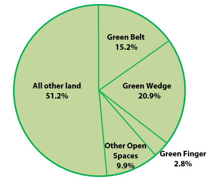
*Approximate figures. ‘All other land’ includes built development and residential gardens.
10.17 Green Infrastructure is protected from inappropriate development and, where possible, enhanced.
10.18 In order to assist delivering the Garden Town principles in developments in the Harlow and Gilston Garden Town, new Strategic Green Infrastructure must be included within Master Plans for such development and it must link with existing Green Infrastructure in Harlow, for example the Green Wedges. One such opportunity is the extension of Harlow’s existing Green Wedge network through the Strategic Housing Site East of Harlow to maintain the existing Green Wedge link to the countryside. Further guidance is provided in other policies.
10.19 The Council will work with adjoining Councils and other appropriate bodies, through the Duty to Co-operate and the Harlow and Gilston Garden Town, to bring forward the ‘Stort Riverpark’, as well as future Green Infrastructure projects to maintain and improve footpaths, cycleways and bridleways and wildlife corridors across the district. The actions and measures contained in the Water Framework Directive will be used to provide opportunities for the Stort Riverpark.
10.20 Reflecting the importance of Green Infrastructure in Harlow, the Council is part of ‘GreenArc’, a partnership of organisations around London, including neighbouring county, district and borough Councils, DEFRA and the Essex Wildlife Trust.
GreenArc has a number of aims, including conserving and enhancing key strategic Green Infrastructure resources such as the Stort Valley, and creating and promoting improved links between settlements and the wider countryside.
WE2 Green Belt, Wedges and Green Fingers
Harlow is surrounded by Green Belt and has a network of Green Wedges and
Green Fingers, allocated on the Policies Map.
10.21 The Green Wedges and Green Fingers were originally included as ‘landscape wedges’ and ‘parkways’ in Sir Frederick Gibberd’s landscape-led master plan for Harlow. They were designed to embrace natural features such as valleys, woods and brooks, and separate the neighbourhoods with open spaces which could be used by residents.
10.22 Green Wedges and Green Fingers are, therefore, fundamental to the character of Harlow and are an enduring legacy of Sir Frederick Gibberd’s original master plan. Nowadays they continue to make a significant contribution to the district’s Green Infrastructure, performing their identified important roles, and previous Local Plan consultations have provided evidence that they are highly valued by Harlow residents.
10.23 The extent of Green Wedges and Green Fingers in Harlow, as allocated on the Policies Map, is shown in Fig. 10.2, overleaf.
Fig. 10.2: Green Wedges, Green Fingers and Green Belt in Harlow
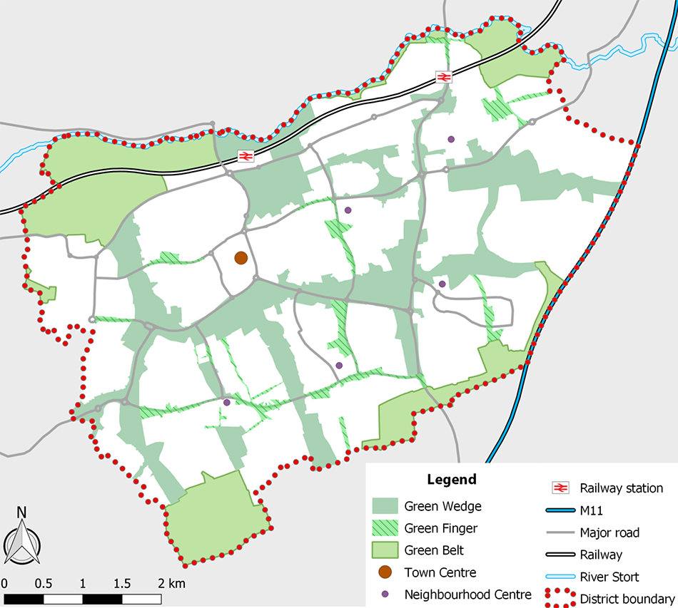
Contains OS data © Crown copyright and database right (2020). All rights reserved. Harlow District Council Licence No.100019627 (2020). Contains OpenStreetMap data © OpenStreetMap contributors. The National Rail logo is a registered trademark in the name of the Secretary of State for the Department for Transport.
10.24 The Green Wedges and Green Fingers are protected from inappropriate development.
10.25 New development must incorporate new Green Wedges and/or Green Fingers, depending upon the size of the development, preferably linked to existing Green Wedges, Green Fingers or the Green Belt.
10.26 In order to contribute to the delivery of the Garden Town principles in developments in the Harlow and Gilston Garden Town, there is an opportunity for a new Green Wedge to be extended into the Strategic Housing Site East of Harlow, which forms part of one of the new four Garden Town Communities, linking with the existing Green Wedge to the west and the Green Belt (in the Epping Forest District) to the east.
10.27 This new Strategic Green Infrastructure would, in particular, contribute to the Garden Town principles of “combining the best of town and country to create healthy communities, including opportunities to grow food” and the provision of
“a comprehensive green infrastructure network and net biodiversity gains”.
WE3 General Strategy for Biodiversity and Geodiversity
Internationally Designated Wildlife Sites.
Nationally Designated Wildlife Sites
Compensation for the harm will be required.
Locally Designated Sites of Wildlife Value10.28 Harlow benefits from a range of biodiversity assets, many of which pre-date the development of the New Town, such as ancient woodland and well-established sites of wildlife importance. Sir Frederick Gibberd’s master plan for Harlow sought to retain these assets in order to preserve the rich diversity of habitats in the district.
10.29 Many of Harlow’s open spaces have been designated for their local and national wildlife importance, including 42 Local Wildlife Sites and three Sites of Special Scientific Interest (SSSIs). Two of these SSSIs are located at Parndon Wood in the south and the other located in the north-west at Hunsdon Mead. There are currently no designated geodiversity assets in Harlow, although such assets may be identified in the future.
10.30 All biodiversity and geodiversity assets in Harlow are protected from inappropriate development.
10.31 Designated biodiversity and geodiversity assets are allocated on the Policies Map. The order of asset type follows the hierarchy in this policy (i.e. within the district Sites of Special Scientific Interest are the highest order asset type).
Non-designated assets of biodiversity and geodiversity importance, which extend the geodiversity and network of biodiversity and open spaces across the district, are identified in Evidence Base studies.
10.32 The Council will work with Natural England, the Essex Wildlife Trust, the Biological Records Centre, Essex County Council and other bodies to conserve, enhance, protect and manage protected sites and landscapes in accordance with their level of international, national, regional or local importance.
WE4 Safeguarding Wildlife Sites Beyond the District Boundary
Development in the plan area, either alone or in combination with other plans or projects, may have an adverse effect on the integrity of the Epping Forest Special Area of Conservation (SAC) as a result of disturbance from recreational activities or air pollution from increased vehicle movements.
Where significant effects on the Epping Forest SAC alone or in combination are likely, a project level Habitats Regulation Assessment may be required.
Development may also have an adverse effect on Hatfield Forest Site of Special Scientific Interest (SSSI) as a result of disturbance from recreational activities.
In relation to Epping Forest and/or Hatfield Forest, development will be required if necessary to include avoidance or mitigation measures as set out in the respective Mitigation Strategies to be adopted by the Council which may include:
Where necessary, contributions towards the measures set out in the Epping Forest Mitigation Strategy will be sought from developments within the Epping Forest Recreational Zone of Influence (ZOI) in order to mitigate and avoid in-combination effects on the Epping Forest Special Area of Conservation (SAC). If necessary contributions will also be sought to address any in-combination air pollution impacts.
10.33 Whilst there are no European designated sites within the district boundary, there are three which are located within sufficient proximity that there could be impact pathways arising from development in the Local Plan such that the integrity of the sites could be affected. These are Epping Forest SAC, Wormley-Hoddesdonpark Woods SAC and the Lee Valley SPA/Ramsar site. However, of these the habitats regulation assessment produced in support of the plan demonstrates that only in the case of Epping Forest SAC is an adverse effect likely unless satisfactory avoidance or mitigation is put in place.
10.34 Adverse effects may arise due to disturbance from recreational activities as a result of the additional population in the area and air pollution from additional vehicle movements through the forest. In addition, adverse effects may arise
in the case of Hatfield Forest, a nationally designated SSSI, due to disturbance from recreational activities.
10.35 A visitor survey undertaken in 2017 found that 75% of visitors to Epping Forest arise from within 6.2 km of its boundary which can be considered the core recreational catchment area or ‘zone of influence’. This only involves a small part of the south of the district. In the case of Hatfield Forest, however, the catchment area extends to 14.6 km, which includes the whole of the district and all four proposed Garden Town Communities. Further visitor surveys will be undertaken from time to time for monitoring purposes and may result in changes to these zones of influence.
10.36 In order to avoid potentially adverse effects on these two sites due to recreational pressure from new residents, the Councils concerned are working with Natural England and the site owners to develop suitable mitigation strategies which will be formally adopted as supplementary planning guidance in due course. If necessary, new development in the district will be expected to include or provide the avoidance and/or mitigation measures set out in these strategies which will be updated from time to time to take account of new scientific evidence or monitoring information.
10.37 In the case of the large housing site East of Harlow, which lies outside the zone of influence of Epping Forest SAC but well within that of Hatfield Forest SSSI, strategic green infrastructure will be required within the development to maximise its self-sufficiency for informal recreation and this may meet the necessary requirements.
10.38 In terms of air quality, it is estimated that 99% of all additional vehicle movements through Epping Forest SAC during the plan period will arise from growth in Epping Forest district rather than the neighbouring authorities including Harlow.
Natural England agree that growth in Harlow district will have a small or negligible effect and in this instance it would be reasonable for air quality mitigation measures to be the responsibility of Epping Forest district. Nevertheless, in case the position changes in future, criterion (d) is included in Policy WE4.
10.39 Policy WE4 will be implemented in the context of co-operation between the Councils and other bodies concerned with the protection of each site.
Harlow Council is committed to this co-operation and, following full discussion and agreement, will formally adopt supplementary planning guidance setting out any necessary requirements for development within its district.
WE5 Heritage
Heritage assets and their settings found within the district will be conserved or enhanced. The types of asset designation are:
Locally listed buildings are known as non-designated heritage assets. The Conservation Areas, Scheduled Monuments and a Registered Park and Garden are identified on the Policies Map.
10.40 National planning policies and guidance outline the rationale behind the designation of heritage assets, with special architectural or historic interest being at the core of any designation decision. National planning policies also set out the hierarchy of significance of historic assets. The Department for Culture, Media and Sport (DCMS) designates listed buildings and Scheduled Monuments. Locally listed buildings have also been identified which contribute towards the district’s heritage. The district’s ten Conservation Areas have been designated because of their special architectural or historic interest. These areas are kept under review and amended, and where appropriate, new areas designated.
10.41 Harlow has several Scheduled Monuments including a number of historic moats and burial mounds, earthwork remains of medieval villages, a barn, a chapel and remnants of Roman villas and temples. The district has a rich historical past and contains various archaeological remains, which were preserved during the development of the New Town.
10.42 Harlow has one Historic Park and Garden to the east of the district which was previously owned, developed and maintained by Sir Frederick Gibberd.
The gardens and the house are located within the Stort Valley to the east of Harlow.
10.43 The heritage assets and their settings are protected from inappropriate development.
10.44 The register of nationally listed buildings is maintained by Historic England.
The register of locally listed buildings is available for inspection on the Council’s website online and may be revised during the Local Plan period.
10.45 The Council has completed character appraisals and management plans for several of the district’s Conservation Areas. This is part of the ongoing monitoring and review process.
< Previous | ^ Top | Next >