
Improving Linkages within NE Enfield and to the surrounding area is critical to securing long-lasting change. This Movement chapter sets out policies in relation to pedestrian, cycle, bus, rail and car movement.
4.1.1 Chapter 2 of this AAP sets out an overview of the issues and opportunities in relation to movement within North East Enfield, as well as connections to the wider area. North East Enfield appears to have relatively good transport links - it is close to the M25, and there are two rails lines and five stations. However, access to the M25 is indirect, convoluted and congested - this is particularly problematic for the logistics / distribution businesses based in NEE. Train services are infrequent - there are generally only two trains per hour.
4.1.2 Improving access and movement for all modes within NEE is a key issue, particularly if Enfield is to accommodate housing and employment growth in the future. Consultation with local businesses has highlighted transport as a key issue. Much of Enfield’s business and residential communities currently relies on motor vehicle travel. It is essential that the use of more sustainable forms of transport is encouraged and a balance is struck between the need for good access to the area and the need to promote the principles of sustainable travel. This AAP promotes active forms of travel (walking and cycling) from the strategic down to the neighbourhood level with policies that aim to overcome existing and potential future severance caused by the north-south railway lines.
4.1.3 Further detail on transport and movement issues is provided in the Baseline Update document that accompanies this AAP. In summary, the key challenges and opportunities are to:
4.2.1 Improving access and movement for all modes within North East Enfield is a key issue, particularly if Enfield is to accommodate housing and employment growth in the future. Much of Enfield’s business and residential communities currently relies on motor vehicle travel. This is evident from the Census 2011 data for method of travel to work. NEE also has a high car ownership in comparison with some of the other outer London boroughs (93% compared with 79% in Waltham Forest and 61% in Haringey). It is essential that the use of more sustainable forms of transport is encouraged and that a balance is struck between the need for good access to the area and the need to promote the principles of sustainable travel.
4.2.2 Walking and cycling in the area can be difficult. Although the area has strategic walking and cycling routes running north-south through the Lee Valley Regional Park, the pedestrian and cycle environment is disjointed and often a rather hostile environment. Making walking and cycling a pleasant and convenient means of getting around is key to securing a modal shift.
Policy 4.1: Encouraging Modal Shift The Council will work with developers and existing occupiers in encouraging modal shift from private modes of transport to public transport, walking and cycling. The Council will encourage implementation of travel plans and parking management strategies through the planning application process for new developments. This policy is closely aligned with the AAP proposals on east-west pedestrian/ cycle linkages and bus improvements to encourage modal shift. |
Policy 4.2: Improving the Quality of the Pedestrian and Cycling Environment The Council will work with partners to secure a step-change to the quality of the existing pedestrian and cycle environment, providing attractive, safe and convenient links. Developers will be required to create high quality streets and spaces within new development that connect to the wider area. Where appropriate, new development will be required to contribute to the improvement of pedestrian and cycle routes within the site’s immediate context. |
Policy Context for Chapter 4: Movement |
|
|---|---|
London Plan |
Policy 6.1 Strategic approach Policy 6.2: Providing public transport capacity and safeguarding land for transport Policy 6.9 Cycling Policy 6.10 Walking Policy 6.12 Road network capacity |
Upper Lee Valley Opportunity Area Planning Framework (July 2013) |
Objective 7 3.2: The transport vision and challenge 3.4: Improving rail connectivity 3.5: Roads and surface transport 4.3: Opening up the Lee Valley Regional Park 8.3: Opening up the Lee Valley Regional Park |
Core Strategy (Adopted Nov 2010) |
Policy 24: The road network Policy 25: Pedestrians and cyclists Policy 26: Public transport Policy 27: Freight |
Adopted Development Management Document (November 2014) |
Policy DMD45: Parking standards and layout |
Other Sources |
National Planning Policy Framework National Planning Policy Guidance Lee Valley Regional Park Development Framework - Area 5 Proposals Core Strategy Transport Assessment/Appendices [2009] A1010 Study (Halcrow), July 2010 Upper Lee Valley Transport Study (JMP), 2006 Rail Options Study (Halcrow) Enfield Cycle Action Plan 2013 Cycle Routes in Enfield, Oct 2013 LB Haringey Cycle Map Enfield Mini Holland Bid Document, Dec 2013 Northern Gateway Access Package (NGAP) background documents |
 |
 |
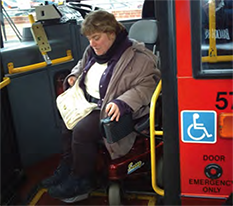
Encouraging a shift from the private car to more sustainable modes of transport is a key aim of this AAP |
|
4.3.1 The Council wants to ensure that improvements to transport are coordinated across NEE, so that there is a joinedup approach to encouraging a shift towards more sustainable means of travel. The Council is leading the project known as the the Northern Gateway Access Package (NGAP) which will provide this coordinating framework. NGAP will coordinate transport improvements across NEE as a whole with the aims of:
4.3.2 Through the detailed technical assessment of NGAP, a sequential approach will be taken to the consideration of options, starting with measures to encourage a shift towards non-car modes, then local traffic management measures, and finally upgrading the highway network. This will bring together a range of transport improvement options that may potentially include::
4.3.3 The West Anglia Mainline Enhancement project will bring increased train frequencies, so significantly improving accessibility the eastern part of NEE and opportunities for improvements to stations and their environs. The increased capacity on Mainline routes will aid in developing Enfield’s image as an employment focussed destination. The increased frequencies towards employment centres such as Stratford will also aid in improving the residential market. However, the increase in train frequencies is likely to result in the closure of level crossings at Brimsdown and Enfield Lock stations. The resulting access issues for vehicles, pedestrians and cyclists are being investigated and opportunities for improving access considered. As plans to develop future transport infrastructure are prepared the Council will do all that it can to secure east west connections so as to prevent fragmentation of communities and avoid areas of isolation.
4.3.4 Expanding the railway line to accommodate three or four tracks is likely to require a full re-design of Ponders End, Brimsdown and Enfield Lock stations within the NEE. These stations are presently designed with limited scope to expand. Options for enlarging the stations, adding additional platforms, improved access arrangements and station realm will be considered in liaison with the train operating company and Network Rail.
4.3.5 The Lee Valley Regional Park Authority (LVRPA) Area 5 - Park Development Framework Proposals (part of the evidence base to NEEAAP) should be considered alongside the policies below.
Policy 4.3: Northern Gateway Access Package As set out in Core Strategy Policy 24, the Council will work with partners to continue to consider the potential merits, benefits and impacts of the NGAP proposals to improve accessibility and movements within NEE by all modes, particularly freight, to support the existing and new businesses in the Upper Lee Valley. NGAP will include a package of projects to improve accessibility and movement for pedestrians, cyclists, public transport users and freight in the NEE area. |
Policy 4.4: West Anglia Mainline Enhancement Project As part of NGAP, the Council supports the proposed capacity enhancement of the West Anglia Mainline. As set out in Core Strategy Policy 24, the Council will work with the Department for Transport, TfL and Network Rail to ensure adequate alternative arrangements are provided in association with any closure of level crossings on the West Anglia mainline in association with the increased rail service frequencies. The Council will work with train operating company and Network Rail to work on the station realm incorporating requirements for pedestrian and cycle crossings, inclusive accesses to the station platforms and any over station development. TfL and Network Rail will continue to investigate the feasibility of Crossrail 2 which is currently proposed to serve this rail corridor. |
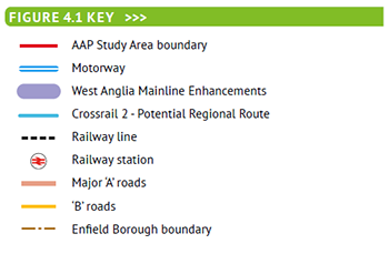
Figure 4.1: Potential Major Infrastructure Projects As Part of NGAP

4.4.1 North East Enfield has access to some good northsouth pedestrian and cycle links, particularly adjacent to the River Lee Navigation, Mollinson Avenue and the A10 Great Cambridge Road. The A1010 Hertford Road has the potential to provide a good north-south link subject to improvements being made for cyclists. East-West links are less direct and unclear, and the impact of West Anglia Mainline Enhancements could further reduce their effectiveness.
4.4.2 This part of the AAP sets out specific proposals for improving east-west links. These are not the only routes that will be used by pedestrians and cyclists: other streets, paths and open spaces also form an important part of the network. However, the six routes identified in Figure 4.2 opposite will form the main focus for improvements. These routes have been identified as they connect key destinations together, including:
4.4.3 Connecting these destinations together with clearly identifiable, direct and attractive routes will improve access to employment, community and social facilities, and access to public transport for residents of the NEE area. Improved access is critical to supporting other policies in this AAP, particularly in relation to economic activity.
4.4.4 Some of the routes are already identified in LBE’s Cycle Routes Strategy, or incorporate ideas developed as part of the ‘Mini-Holland’ bid for funding to the Mayor of London. The proposals set out in this AAP therefore form part of a coordinated approach with other Council initiatives.
4.4.5 For each route, we set out:
Route A: Turkey Street - Ordnance Road - Enfield Lock Station - Lee Valley Park
Policy 4.5: Turkey Street - Ordnance Road - Enfield Lock - Lee Valley Park Pedestrian and Cycle Route Prior to any closure of the level crossing at Enfield Lock Station, the Council will develop a scheme for improving this route for vehicles, pedestrians and cyclists. The scheme should include:
|
Route B: Greenville Cottages - Longfield Avenue - Albany Park - Turkey Brook - Lee Valley Park
Policy 4.6: Greenville Cottages - Longfield Avenue - Albany Park - Turkey Brook - Lee Valley Park Pedestrian and Cycle Route The Council will develop a scheme for improving this route for pedestrians and cyclists. The scheme should include:
|
Route C: Brick Lane - Durants Park - Green Street - Lee Valley Park
Policy 4.7: Brick Lane - Durants Park - Green Street - Lee Valley Park Pedestrian and Cycle Route The Council will develop a scheme for improving this route for pedestrians and cyclists. The scheme should include:
|
Route D: Southbury Road - Nags Head Road - Lee Valley Road
Policy 4.8: Southbury Road - Nags Head Road - Lee Valley Road Pedestrian and Cycle Route The Council will develop a scheme for improving this route for pedestrians and cyclists. The scheme should include:
|
Route E: Lincoln Road - South Street - Wharf Road - Lee Valley Park
Policy 4.9: Lincoln Road - South Street - Wharf Road - Lee Valley Park The Council will develop a scheme for improving this route for pedestrians and cyclists. The scheme should include:
|
Route F: A1010 Hertford Road
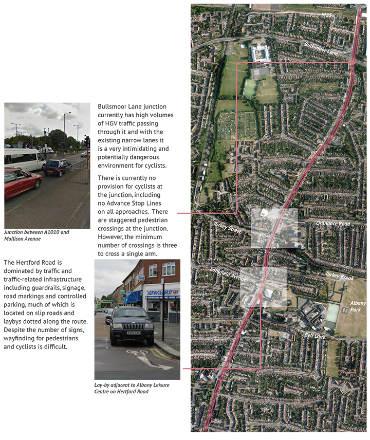
The A1010 is identified in the Council’s bid for ‘Mini Holland’ funding as a key commuter cycle route to Central London, Haringey and Hackney. It also offers direct cycling access to a significant part of the borough and to major employment and regeneration areas in the Lee Valley. The A1010 is suffering from an identity crisis caused by its mix of High Street environments and traffic corridors, and the Council wants to create a best-practice north-south route that becomes a place not just for cycling, but for people. This is particularly important in the Local Centres, where there is an opportunity to reduce traffic speeds and create a more cycle/pedestrian friendly environment.
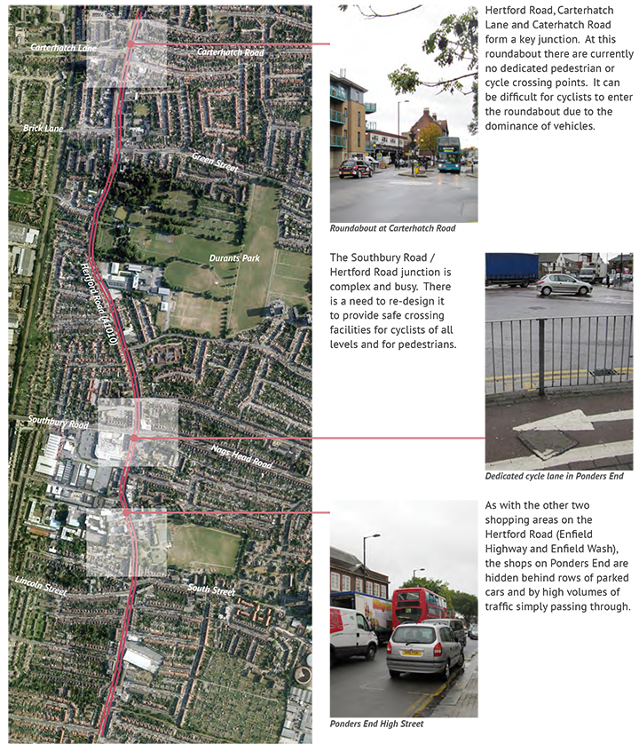
Policy 4.10: A1010 Hertford Road The Council will re-design the Hertford Road Corridor to provide a road that is not only enjoyable to cycle along but also to walk along. Key principles of the re-design to include:
|
4.5.1 On-going improvement of bus routes is vital to maintain a comprehensive and attractive network of bus services to meet the transport needs of North East Enfield. A robust bus network supports new development, and offers a flexible means to respond sustainably to emerging travel demands.
4.5.2 The North East Enfield area has direct access to approximately a dozen bus routes, but there is a need to strengthen this service provision to meet the challenges of growth within NEE. The overarching objective to deliver better bus services is supported by five integrated public transport policies, as described below.
4.5.3 Bus Service Level: Frequent bus services provide the capacity needed to support future growth in transport activity, and play a significant role in making public transport a mode of choice.
4.5.4 Bus service frequencies should be closely aligned to changes in development densities and future travel demands. The 2009 NEEAAP options report cited concerns about a lack of bus services to and from employment and residential areas, and recommends improved alignment of bus service frequencies to new residential and employment developments.
4.5.5 Frequencies will need to be increased on links and at interchange nodes where:
4.5.6 Links for intensification of bus services are identified in Figure 4.3. Priority areas for bus service intensification reflect development aspirations for NEE and key corridors include:
4.5.7 To support the 24 hour economy in industrial areas such as Brimsdown there is a need to extend the coverage of nightbus services. A priority link for introduction of a new nightbus is the A1055 Mollison Avenue.
Policy 4.11: Enhancing the Bus Network The Council will continue to work closely with TfL to develop an enhanced network of bus routes and services within North East Enfield to better meet the needs of existing residents and businesses within the area and to meet the growing demand that will be generated by proposed new developments. |
Policy 4.12: Maintaining Bus Accessibility at Enfield Lock The 121 bus service crosses the railway line at Enfield Lock. The Council will work with TfL to develop an alternative service to replace the current 121 to ensure that access to the Enfield Lock area is at least as good as current, should the crossing close. Any new service should include standing and interchange facilities preferably at Enfield Lock Station but potentially at Brimsdown Station. |
Photograph of new bus operating in London
Figure 4.3: Existing Bus Frequencies And Proposed Frequency Increases
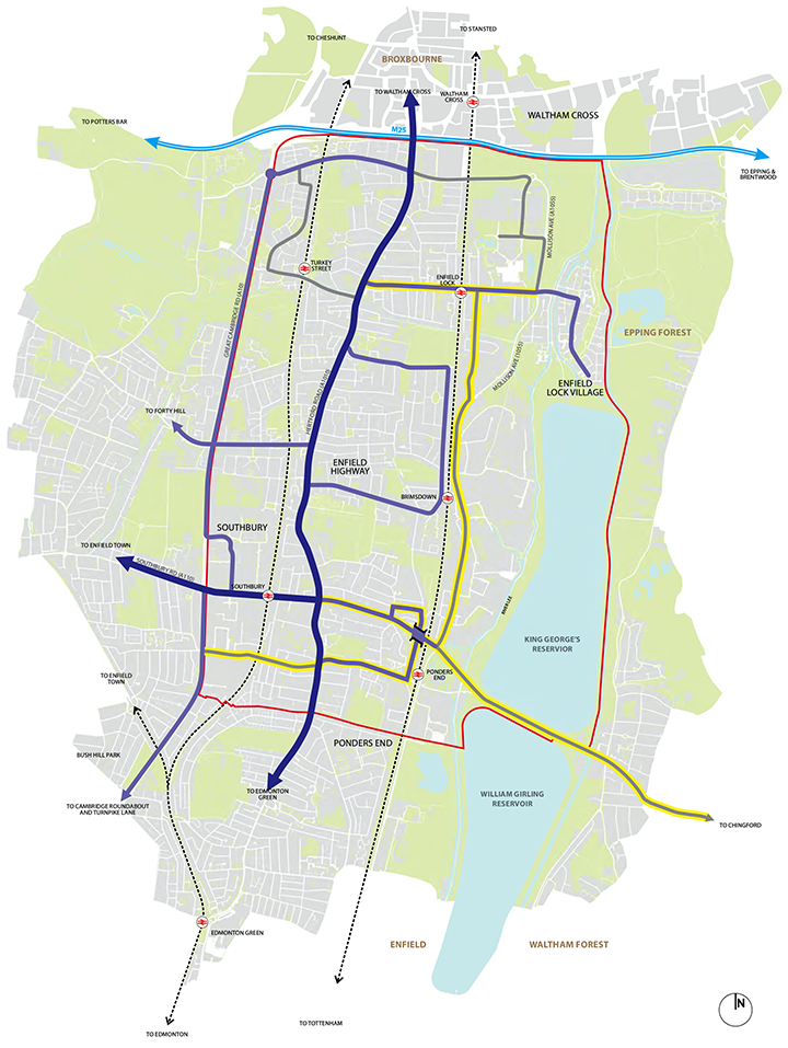

4.5.8 Bus Network Accessibility: The economic vitality of North East Enfield would be substantially enhanced through the provision of new and extended bus services. Opportunities for enhancement to the North East Enfield bus network include development of the following new links:
4.5.9 In addition bus links to the North Middlesex University Hospital need to be strengthened.
4.5.10 Major infrastructure works on the local rail network such as possible level crossing closures at Brimsdown and Enfield Lock should be used as trigger points for the planned introduction of new bus / rail interchange hubs. These hubs would have enhanced passenger facilities, and might require adjustment to bus service times, frequencies and destinations.
4.5.11 Bus reliability: Existing and potential public transport customers expect buses to be reliable and efficient. To compete with other transport modes, bus services must achieve a good standard of reliability, to provide a dependable transport service that meets or exceeds user expectations.
4.5.12 Improved reliability of bus operations, and associated reductions in average bus journey times, can be achieved through the strategic introduction of traffic management measures. These could include:
4.5.13 Opportunities to deliver enhanced bus priority provision should be embedded into the planning of new developments, and reviews of existing highway infrastructure. The transport plans for new developments must seek to incorporate bus priority measures from an early stage in the design development process.
4.5.14 Amenity for bus users: High quality bus stops are fundamental in the delivery of a positive bus user experience. The amenity of the waiting space at bus stops provides an important first impression of a bus service. A well designed bus stop thus becomes a positive advert for bus services.
4.5.15 All bus stops within North East Enfield need to achieve a minimum quality standard in terms of infrastructure and information provision. The minimum standard required within the NEE area is a bus stop layout that is compliant with the requirements of the Disability Discrimination Act (DDA), and essential facilities for bus users such as timetable information.
4.5.16 Effective bus services require easier access to public transport information for potential bus users, and the reassurance offered by real time passenger information to help retain existing bus users. To encourage bus use and enable more informed transport decision making, employers and responsible authorities for public buildings within North East Enfield should be encouraged to provide better access to real time bus information.
4.5.17 Within North East Enfield there are opportunities to deliver improved access to bus information, including:
Policy 4.13: Improving bus services The Council will continue to work closely with TfL, major employers and other stakeholders to ensure that:
|
4.6.1 Road Task Force: The Road Task Force report was published in July 2013 and provides a strategic review that sets out a vision of how London can provide quality streets to cope with the expected population increase and achieve economic growth in London. Outer London is identified as one of the strongest assets in London and a key to future success. The RTF aims to maintain and enhance a highquality of life and provide attractive places to live and work and raise families in outer London boroughs. These then can contribute to creating a network of diverse, accessible and safe neighbourhoods. To achieve that, there must be efficient access to jobs and services and recognition of diversity of the area, from quieter residential streets to more industrial suburbs.
4.6.2 In regards of roads and streets, this will mean:
4.6.3 Other objectives include unlocking growth and regenerating London sustainably; creating high-quality growth hubs; as well as supporting all London’s town centres to serve as growing residential locations and economic, social and community centres; ensuring accessible employment and services to all.
4.6.4 The RTF proposes nine street-types, defined by their “place” and “movement” roles; and are associated with a set of priority uses, strategic performance measure and potential types of interventions. They are intended for the purpose of TfL’s and boroughs’ planning and decision making, which include agreeing on priority functions and development of toolkit of measures. These are: Arterial Roads; High Roads; City Hubs; Connectors; High Streets; City Streets; Local Streets; Town Square/street; and City Places.
Policy 4.14: Design of Road Network The Council will work towards developing a comprehensive network design specific to road users and the functions served in accordance with the Road Task Force, July 2013 as summarised in Table 4.1. |
Table 4.1: RTF road categorisations compared with examples within NEE
Street Type |
Description / Functions |
Example within NEE |
Arterial Roads |
Reliable major routes for large volume of traffic that mitigate the impact on adjacent communities |
A10 Great Cambridge Road |
High Roads |
Reliable major routes through London that provide vibrant, safe, secure and well-maintained urban environments and make shops and services easily accessible. |
Section of A1010 between Nags Head Road and Green Street; A1010 between Carterhatch Road and Hoe Lane; A1010 to the north of Ordnance Road. |
City Hubs |
Vibrant focal points for business and culture. They reduce the impact of high traffic volumes while accommodating high pedestrian flows, bus access and essential traffic |
Potentially Brimsdown station area. |
Connectors |
Reliable routes for medium distance and local road journeys, comfortable roads for cyclists and safe and secure routes for pedestrians |
Bullsmoor Lane; Ordnance Road; Green Street. |
High Streets |
Reliable major routes through London that provide vibrant, safe, secure and well-maintained urban environments and make shops and services easily accessible. |
Ponders End High Street, Enfield Wash Local Centre; Enfield Highway Local Centre. |
City Streets |
Provide a world-class, pedestrian friendly environment while ensuring excellent connections with the wider transport network |
Potentially Nags Head Road. |
Local Streets |
Quiet, safe and desirable residential streets that foster community spirit and local pride |
Hoe Lane, Chestnut Road. |
Town Square/street |
A focus for community activity and services (retail, leisure, public, etc) with ease of pedestrian movement a priority |
Ponders End station area, |
City Places |
World-class, pedestrian friendly environment to support their role as places of major significance and encourage high levels of street activity and vibrancy |
- |
< Previous | ^ Top | Next >