Adopted October 2014
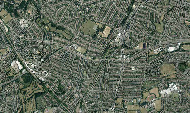
An aerial view of the North Circular area
Image © 2014 The GeoInformation Group

Enfield Local Plan - relationship of key component documents

What is this document for?
This Area Action Plan sets out a planning framework for the future of the North Circular corridor between the A109 at Bounds Green and the A10 Great Cambridge Road. The preparation of a North Circular Area Action Plan (NCAAP) has been a longstanding Council commitment as confirmed in the Enfield Core Strategy (2010). Its adoption marks a significant step change for the area, supporting and guiding regeneration that will lift decades of uncertainty.
The key task of this area based Plan is to respond to and co-ordinate an on-going cycle of change where, for the first time in years new development is being delivered on the ground and future investment is secured. Development in the North Circular corridor will be guided by the adopted vision, strategy and policies of this Plan. This document formally sets out the Council’s proposed approach to the regeneration of the area, including proposals for new housing, businesses and supporting infrastructure such as schools, transportation and community facilities. After decades of seeing limited investment, the corridor is now alive with proposals that will provide for strong and enduring sustainable communities in South West Enfield.
This Plan has evolved following earlier consultation and engagement with the communities and stakeholders in the area that culminated in its submission for public examination in August 2013. The Planning Inspector formally delivered his report in April 2014 concluding that the NCAAP meets the criteria of soundness set out in the Government’s National Planning Policy Framework and is an appropriate basis for planning along this section of the North Circular Corridor.
How to use this Plan?
The adopted NCAAP forms an integral part of Enfield’s Local Plan, sitting alongside the adopted Core Strategy (2010), the adopted New Southgate Masterplan (2010), the emerging Development Management Document (DMD) (2014), and other area based plans being prepared for Enfield’s strategic growth and regeneration areas. This Plan provides the more detailed and area-specific planning policy and development framework for this part of the borough. New development proposals coming forward within the area will be expected to accord with the policies and proposals contained within this document unless other material planning considerations indicate otherwise. The NCAAP should also be read in conjunction with the Core Strategy, New Southgate Masterplan, and DMD and is not intended to duplicate policies within these interrelated documents.
The Council, together with partners and stakeholders will be instrumental in delivering the wider vision for South West Enfield through the North Circular Area Action Plan. All of this is to ensure that Enfield continues to be a place where people want to live, work and visit. Area Action Plans are statutory planning documents that are specifically designed to:
Working with the community, partners and our neighbours
The adopted NCAAP has been informed by several stages of both formal and informal consultation in accordance with the Enfield’s adopted Statement of Community Involvement (2006) and the Town & Country Planning Regulations (2012).
The Council has worked closely with its neighbours to ensure that the strategic and cross-boundary implications of the NCAAP have been carefully investigated and that this process has fed into the preparation of the Plan. The 2011 Localism Act sets out a ‘duty to co-operate’, which requires such a process. Those partner organisations that are instrumental to the delivery of the NCAAP have also been involved throughout its preparation. The Council’s partners include Transport for London, neighbouring boroughs, in particular Haringey and Barnet, Enfield’s South West Area Partnership and key private sector investors, notably Notting Hill Housing Trust and Mulalley / One Housing Group.
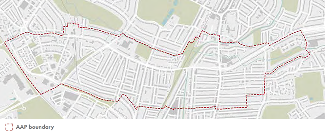
Fig 1. Plan showing the adopted AAP boundary
© Crown Copyright and database right 2012. Ordnance Survey Licence no. 100019820

The South West Area Partnership has been especially instrumental, bringing together and co-ordinating local people and partner organisations to help make positive changes in the area.
What area does the APP cover?
The NCAAP covers the area between New Southgate on the west and the start of the Great Cambridge Road approach to the east incorporating established residential areas of New Southgate, Arnos Grove, Bounds Green, Bowes and the southern end of Palmers Green. The area is traversed along its length by the A406 North Circular Road. A length of Pymmes Brook, a minor tributary of the Lea River, forms part of the area’s northern boundary, Bounds Green Brook runs north-south adjacent to the A406 for part of its length. The New River also passes north-south across the area. Opportunities will be taken to enhance these important watercourses.
Fig 2. The Enfield Spatial Strategy (Enfield Core Strategy, 2010)

THE NATIONAL, REGIONAL AND LOCAL POLICY CONTEXT
National Planning Policy Framework (NPPF)
The Government published its National Planning Policy Framework (NPPF) in March 2012. The NPPF replaced the previous Planning Policy Guidance Notes and Statements under which previous draft versions of the NCAAP were prepared.
The NPPF provides the framework within which local people and their Local Planning Authorities can produce local and neighbourhood plans which reflect the needs and priorities of their communities.
The North Circular Area Action Plan is consistent with the NPPF. Alongside Enfield’s adopted Core Strategy (2010), it contributes towards the implementation of the adopted spatial strategy for the Borough. New Southgate is a significant regeneration area within NCAAP and alongside this document is also guided by the detailed objectives set out in the New Southgate Masterplan, adopted in late 2010.
When considering development proposals within the NCAAP area the Council will take a positive approach that reflects the presumption in favour of sustainable development contained in the National Planning Policy Framework. The Council will always work proactively with applicants jointly to find solutions which mean that proposals can be approved wherever possible and to secure development that improves the economic, social and environmental conditions in the area.
London Plan
The London Plan (2011) and formal alterations (2013) form part of the development plan for Enfield, providing both strategic guidance and development management policies to deliver strategic objectives. The NCAAP is in general conformity with the policies contained within the London Plan.
The Enfield Plan
The Core Strategy has 10 strategic objectives, all of which are relevant to this AAP. However, Strategic Objectives 1 relating to enabling and focussing change, 3 relating to community cohesion and 4 relating to the provision of sustainably constructed new homes are of particular relevance to this NCAAP area.
The Spatial Strategy which underpins the Core Strategy identifies the North Circular AAP area as one which will be a focus of change. The spatial strategy states the “The area has the capacity to accommodate up to 2,000 new homes, largely on land no longer needed for the road improvements and through the renewal of the Ladderswood Estate and the New Southgate area”.
There are a number of key policies contained with the Core Strategy which are central to the policy framework for this AAP, as follows:
Core Policy 1; Strategic Growth Areas, identifies the areas around the North Circular Road and New Southgate as an area of focused growth and housing led regeneration. Core Policy 2; Housing supply and location on new homes outlines the projected supply of housing within the AAP area, with approximately 500 dwellings being identified for each of the Plan’s 5 year phases of development.
Core Policy 17: Town Centres establishes the hierarchy of Town, District, Local Shopping Centres and Parades. The Policy seeks to strengthen the role of Enfield's centres according to this hierarchy using the sequential test to direct development to appropriate sites.
The NCAAP area is supported by three Local Centres at Green Lanes, Bowes Road, and Arnos Grove. Core Policy 17 defines their role as providing core local shopping facilities and services (such as convenience stores, post offices, pharmacies and newsagents) for their respective communities, catering to a catchment area of walking distance. In addition, the NCAAP area is supported by the District Centres of Palmers Green and Southgate where the main bulk food and town centre related services and facilities are located.
Core Policy 44; North Circular Area deals specifically with the North Circular Area and confirms that the indicative housing delivery target of up to 2,000 within the NCAAP over the plan period to 2026 may change as the NCAAP and the New Southgate SPD evolve.
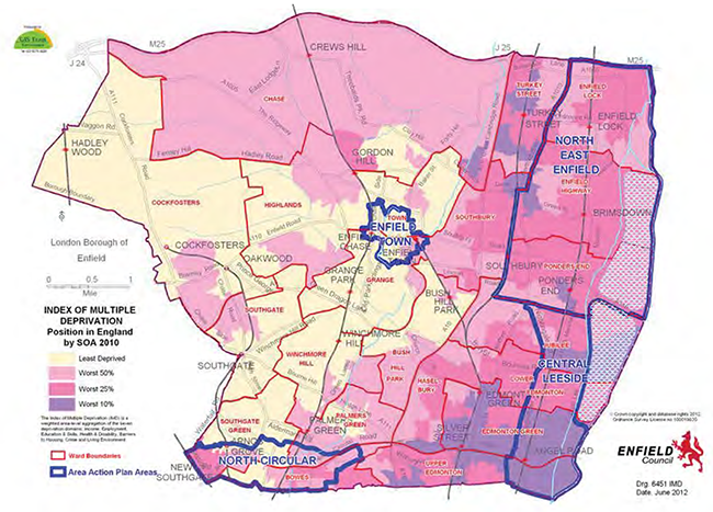
Fig 3. Index of multiple deprivation

The policy confirms that the focus of new mixed use development will be in the New Southgate area. The policy also provides the framework for the provision of community infrastructure with the proposed housing numbers giving rise to an additional two forms of primary school provision. This is endorsed in Core Policy 8; Education where this additional capacity is considered most likely to be required within the period 2015-2020.
Core Policy 45; New Southgate deals specifically with the Regeneration Priority Area of New Southgate which now benefits from a recently adopted SPD masterplan.
Enfield's Development Management Document
In January 2014 the Council formally submitted the Development Management Document (DMD) and Policies Map to the Secretary of State for independent examination. The DMD provides detailed criteria and standard based policies for assessing planning applications. This borough wide document will apply to all planning applications, including proposals within the NCAAP boundary. Once adopted, it will also be part of Enfield's Local Plan and where appropriate, this document provides sign-posting to relevant DMD policies. The DMD document can be viewed online at: http://www.enfield.gov. uk/dmd
The North London Waste Plan
Seven North London Boroughs (Barnet, Camden, Enfield, Hackney, Haringey, Islington and Waltham Forest) are working together as planning authorities to identify sufficient space for facilities to accommodate managing North London’s waste. The North London Waste Plan will set out the planning framework for waste management in these boroughs for the next 15 years. It will identify sites for waste management use and set policies for determining waste planning applications.
The Friern Barnet former Sewage Treatment Works (Pinkham Way), which has been vacant since the sewage treatment plant was closed in 1963, has previously been identified as a potential site for the handling of general waste. The site falls outside of the AAP area and within the administrative boundary of Haringey.
SOCIO-ECONOMIC CONTEXT
The NCAAP area sits within three wards. Bowes Ward covers the largest proportion of the NCAAP area. Southgate Green and Palmer Green wards both have only their southernmost portions in the NCAAP area; the character of the more northerly sections of these wards tends to differ from that of the parts directly around the North Circular Road.
As measured by the Index of Multiple Deprivation (IMD), Bowes ward is the 11th most deprived out of 21 wards in the borough. Breaking the IMD down into specific domains, it is possible to identify the factors at work within the AAP area. In particular it shows that the whole area is affected by environmental issues, vacant properties, and the dominance of the road network, as well as poor access to housing and services and crime. In terms of the other domains of child poverty, income, and employment deprivation there are particular concentrations of deprivation around the western and eastern edges of the AAP area.
It can also be seen that there is a sharp transition in terms of the socio-economic landscape between the NCAAP area and the areas of Southgate Green to the immediate north.