
2.1 The Croydon Local Plan addresses the needs of the borough for new homes and jobs plus the infrastructure needed to support growth from 2011 up to 2036. Determining what these needs are begins with understanding how Croydon became the borough that it was in 2011 and by looking at the challenges it will face from 2011 up to 2036.
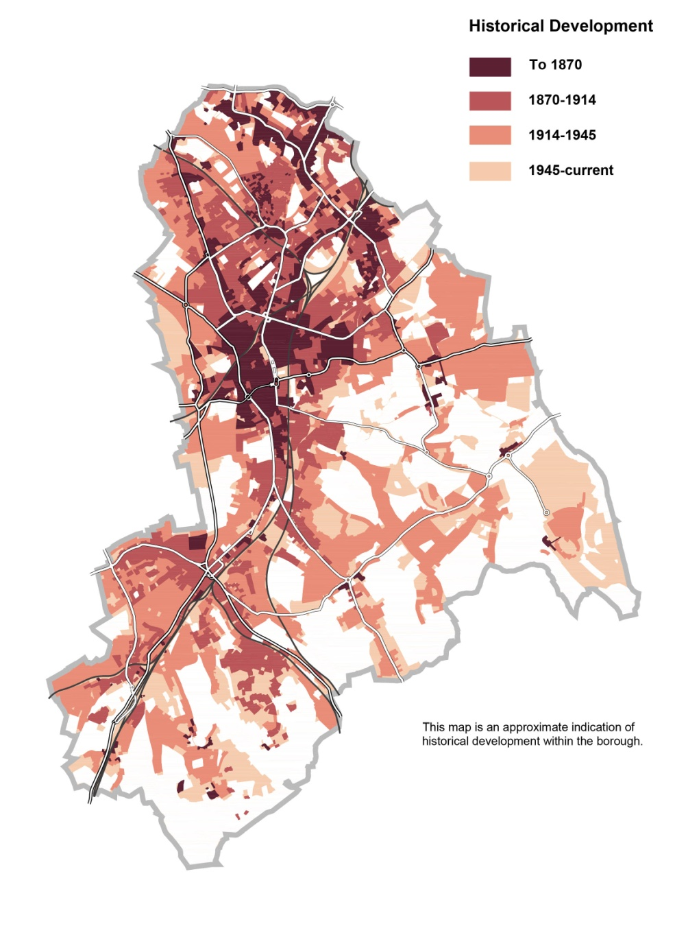
2.2 Croydon historically was a market town, which in the medieval period benefited from the presence of an Archbishop's residence and key trading links with the outlying villages of Addington, Sanderstead and Coulsdon to the south. A period of prosperity in the 18th century saw the development of settlements at Broad Green, Woodside and Thornton Heath. Construction of the pioneering Surrey Iron Railway in 1801-03, initially between Wandsworth and Croydon, created new links for the thriving manufacturing industries along the Wandle Valley. The borough's character was fundamentally changed by the arrival of railway connections to London in 1839 and then Brighton in 1841, with new stations appearing along the line later in the century promoting the rapid development of town centres at Thornton Heath, Norbury and South Norwood. Stations at Purley and Coulsdon likewise encouraged growth of both towns and suburbs. Croydon was incorporated as a borough in 1883 and with subsequent civic enthusiasm rebuilding took place across its towns through the proceeding decades with new buildings and parks. By 1914, the borough had become contiguous with central London.
2.3 1915 saw the arrival of the world's first international terminal building at Croydon Airport (the original London airport); resulting in the subsequent development of industry to the west of the town. A developing road and public transport system also paved the way for suburban expansion further to the south and south eastern edge of the borough, which was newly accessible by car. As a consequence, areas of the countryside were developed for house building, a trend that stopped with the introduction of the Green Belt. The town experienced its most dramatic transformation following the Croydon Corporation Act of 1957. Redevelopment led to an unparalleled office boom, with almost 500,000m2 of office space built or given permission in the town between 1957 and 1964. Private developers also took advantage of new commercial opportunities, with the Whitgift Foundation notably relocating the Trinity School out of the town to release its 11 acres of land for a large new shopping centre between North End and Wellesley Road, which itself was being transformed into an urban motorway.
2.4 Increased emphasis from central government on allowing out of town shopping areas through the 1980's and 90's resulted in a new retail area growing along the A23 (Purley Way). A new station at East Croydon was built in 1992, and Tramlink, in 2000, providing much needed additional transport infrastructure across the borough from east to west.
Figure 2.1: Historical development in Croydon
2.5 By 2011 Croydon as a borough had many strengths and opportunities. It also faced some challenges too, which the Croydon Local Plan sets out to address.
2.6 By 2011 Croydon had become a borough of contrasts. It was a borough with a series of distinct places from Victorian railway suburbs in the north and along the railway line in the valley, towards Purley and Coulsdon to 20th century suburbs on wooded hillsides in the south and away from the railway line in the east. The challenge for the Croydon Local Plan is to respect local character and distinctiveness whilst accommodating growth.
2.7 In Croydon Metropolitan Centre the borough has more shops in one location than anywhere else in London apart from the West End itself. However, in 2011 they faced stiff competition from other centres such as Bromley, Kingston and Bluewater. The Metropolitan Centre had more office floor space than anywhere else in South London and neighbouring districts in Surrey, but many of the offices in Croydon were seen as dated and vacancy had increased. Croydon competes against more recent office developments in Docklands, Redhill and surrounding boroughs. The challenge for the Croydon Local Plan includes rejuvenating a dated Croydon Metropolitan Centre and growing a new residential community and jobs. Improvements to the public realm in the Metropolitan Centre to attract shoppers, employers, workers and new residents are vital to its regeneration and future vitality.
2.8 The growth of retailing along the Purley Way leads to its own challenges of traffic congestion at peak times. The Purley Way employment areas are prime locations owing to their accessibility to the M25 and the rest of London and the Mayor of London's strategic employment protection recognises the demand for industrial premises in Croydon. The challenge for the Strategic Policies are to address ways of reducing traffic impact and making the shift from private transport to more sustainable modes of transport.
Figure 2.2: Deprivation in Croydon relative to the rest of England 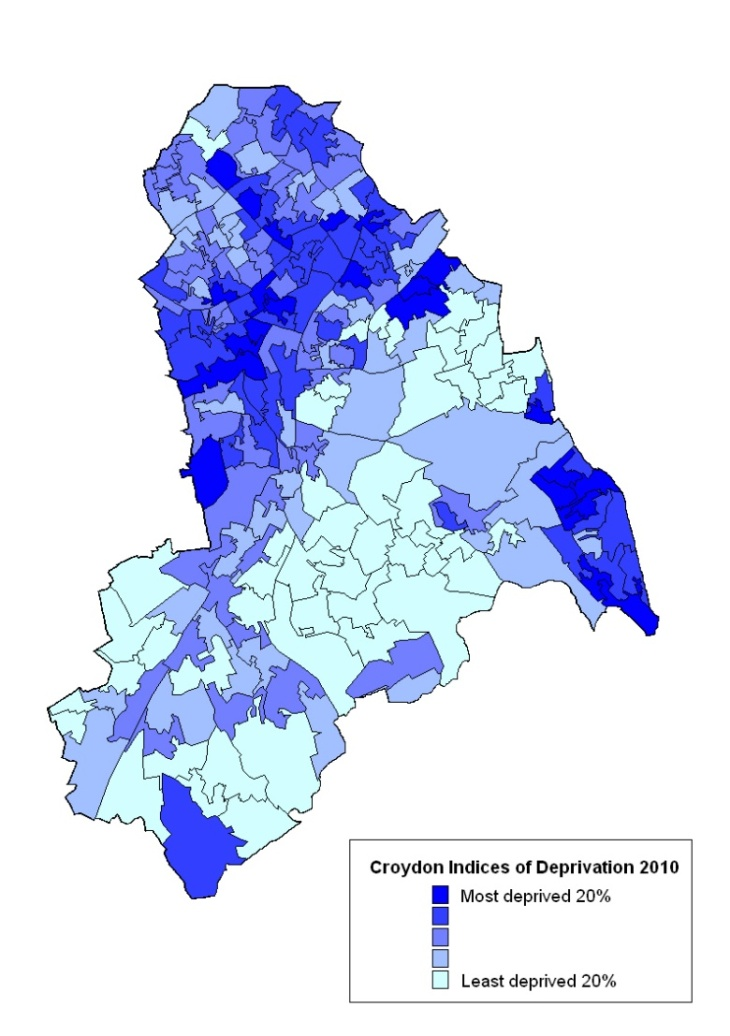
2.9 In 2011 the borough ranked as the 14th least deprived borough in London1 , (out of 33 authorities). Deprivation levels, however, differ greatly, with greater concentrations in the north of the borough and in the places of Addington and Shirley. The Victorian and Edwardian areas of the borough suffer from deprivation as do some of the inter and post-war local authority built housing estates. In general the south and east of the borough incorporate some of the least deprived areas of London. The challenge for the Strategic Policies is to reduce social, economic and environmental deprivation, look at measures to reduce unemployment, improve skills and education, community and environmental conditions and renew housing.
2.10 By 2011 Croydon was the largest borough in London in terms of population (with a population of 363,000 people2 ) and was expected to grow by 30,000 people by 20313 . They will need to have homes in which to live.
2.11 Demographically Croydon is a young borough and in 2011 a quarter of its residents were under the age of 20. However, the residents of the borough are getting older and by 2031 the number of people in Croydon over the age of 65 will have increased by 41% which will bring with it challenges in terms of the types of homes that are needed in the borough and the infrastructure needed to support an aging population. In contrast, the population aged between 20 and 64 will have increased by just 2.5%4 . By 2031 Croydon will also be a more diverse borough with over half of the population being a member of a black and minority ethnic community5 , compared to 36% in 20016 . The challenge for the Strategic Policies is to meet the needs of the population growth, the aging population and the cultural diversity.
2.12 The Green Belt around Croydon together with the protection of open spaces elsewhere in the borough has ensured that over a third of the borough is open space. Whilst this is an asset, it is also a constraint for the borough as it limits the land available for new homes to house Croydon's growing population. The open space is unevenly distributed in the borough creating some areas, mainly to the north, with degrees of deficiency in access to nature and/or open space. The challenge for the Croydon Local Plan is to ensure access and quality of existing open space is improved whilst making the most of the natural resources and adapting to climate change.
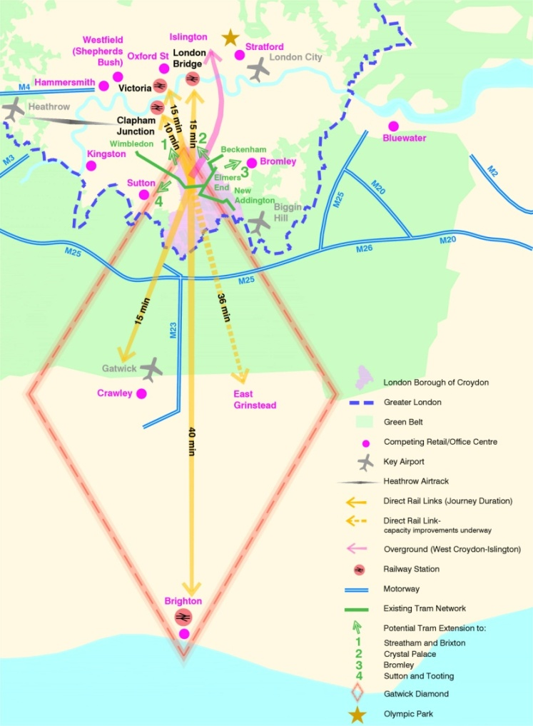
2.13 The future of Croydon needs to be viewed in the context of growth and development in London and the south east of England. At a London level, direction is provided by the Mayor of London through the London Plan.
2.14 Croydon has responded to the Mayor's policy direction in the London Plan to work with neighbouring local authorities and cross borough issues have been considered by the Croydon Local Plan. Looking ahead it will be important for Croydon to build positive relationships with the Wandle Valley regional co-ordination corridor (through south London and outwards towards Gatwick Airport) and the Brighton to London corridor, which includes working closely with the Coast to Capital Local Enterprise Partnership of which Croydon is a member.
2.15 A summary of how Croydon relates to the wider sub-region is shown in Figure 2.3 below.
Figure 2.3 Croydon and its sub-regional context
1 Index of Multiple Deprivation 2010 - Local authority summaries
2 Census 2011
3 GLA 2010 Round Population Projections
4 As above
5 GLA 2009 Round Ethnic Group Population Projections
6 2001 Census
< Previous | ^ Top | Next >