
2.1 The Weymouth Character Area Assessment5 confirms that Weymouth remains an important tourist and recreation destination, with a beautiful seascape and built heritage. Surrounding and overlapping on the north of the neighbourhood area is the Dorset National Landscape (DNL) which is given this status due to the beautiful landscapes. The stretch of coast is a World Heritage Site, the Jurassic coast, important and well known for its geology and fossils.
2.2 Weymouth is the third largest settlement in the county of Dorset, having a population of around 53,000 and is the largest settlement in the Dorset Unitary Council area. Weymouth attracts around half a million staying visitor trips and almost two million-day visits mainly in the summer season. 5,000 jobs are supported by visitor-related spending.
2.3 The built-up area of Weymouth is bound to the north by the South Dorset Ridgeway, a high ridge of land dominating the skyline between Weymouth and Dorchester. This location has been an important place for people for the last 6,000 years, with over 1,000 ancient monuments, some dating back to the Neolithic (4,000 - 2,000 BC). The South Dorset Escarpment follows from the South Dorset Downs of expansive open chalk downland that drain from the escarpment. The South Dorset Ridge and Vale, and Osmington Ridge and Vale are a series of small limestone ridges and clay vales running east to west. Lower Wey and Lorton Valley is characterised by a flat valley floor and flood plain with large areas of wetland. The valley sides provide a more intimate feature. Radipole Lake and Lodmoor have extensive reed beds and areas of open water from the flood plain. These features form an important backdrop and setting for the town, as well as providing important green space within the built-up area.
2.4 The town of Weymouth originates in two small settlements on either side of the river Wey, which eventually developed into the two separate medieval seaports of Weymouth and Melcombe Regis. In the Middle Ages wool was exported via Melcombe Regis and wine imported through Weymouth. The harbour, which they shared uneasily, was at the centre of the economic life of both towns, and from earliest times they quarrelled over it. These quarrels became so bitter that in 1571 they were amalgamated into one borough by Act of Parliament.
2.5 In the Georgian period, when medical science of the day declared sea bathing to be good for the health, Weymouth began its rise as a seaside resort. George III’s decision to come to Weymouth in 1789 for his health, led the town to become the most celebrated and visited watering-place in the land. During the Victorian period the town continued as a popular resort and the harbour flourished with the growth of sea-borne trade with the Channel Islands. The arrival of the railway in 1857 enabled both these aspects of the town’s life to continue to grow. The 20th century with population growth and two world wars had a great impact on the town. The town was badly bombed during World War II and was a key embarkation point for American troops on their way to Normandy in 1944. In the latter half of the 20th century Weymouth’s popularity as a seaside resort declined with the rise of cheap foreign holidays; and by the end of the century harbour trade had virtually disappeared. The end of regular cross-Channel shipping followed not long after.
2.6 The historic growth and fluctuations in economic fortune is evident in the present-day urban form and the varied building types and styles. Weymouth’s past is still very evident in the street pattern, the historic buildings, and heritage features that remain, and is recognised by the many Conservation Areas and myriad of Listed Buildings that can be found in the Weymouth area.
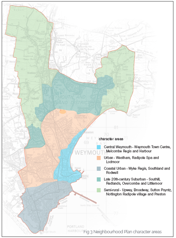
2.7 Five separate character areas (see Map 3) were identified by the Weymouth Character Area Assessment based on “density, constraints, access to facilities, typologies, design styles and era built”. Their different and distinct characters have had influence on the preparation of the Neighbourhood Plan.
2.8 Character Area 1 is the historic core of Weymouth, the Town Centre, the harbour and Melcombe Regis. This area is an urban core/central urban area with higher densities. It contains the rail and bus stations. The area is densely built and contains many houses of multiple occupation. The central area has a large area of policy-protected primary shopping and secondary frontages and many facilities for residents of the wider area of Weymouth.
2.9 Character Area 2 is Westham, Radipole Spa, and Lodmoor which are suburban areas of the town although listed buildings and the Lodmoor Conservation Area form part of its identity. Open gaps and sizeable areas of public open space define the boundary of each area. These areas have access to facilities through either walking or public transport.
2.10 Character Area 3 consists of the semi-rural settlements of Sutton Poyntz, Preston, Broadwey, Upwey, Nottington, and Radipole village, which follow the river valleys and have a distinct character of their own. Listed buildings and the conservation areas are part of the identity and heritage of the area. Open gaps and woodland provide important open spaces for recreation as well as defining the boundary of each area. Some areas have experienced ribbon development. Many of the settlements lack community facilities.
2.11 Character Area 4 is Southill, Littlemoor, Overcombe, and Redlands which developed between the 1960s and present day. These are suburban/urban areas that, with particular reference to Southill and Littlemoor were designed around central facilities and community buildings for day-to-day needs, sports, community events and to encourage social interaction and maintain health. Access to services and jobs is somewhat limited.
2.12 Character Area 5 is Wyke Regis, the original parish of Weymouth, which is now its own distinct area and includes Southland and Rodwell. It has a significant coastline. It lacks access to employment facilities within walking distance. Listed buildings, four conservation areas and Sandsfoot Castle form part of its identity and heritage. Open gaps between settlements provide important open spaces for leisure.
2.13 The Sutton Poyntz Neighbourhood Plan identified five distinct character areas – Historic Core, West Side, Plaisters Lane North, Gateway, Puddledock South – within the confines of the village of Sutton Poyntz (refer to descriptions and map in Appendix D Annex). A similar tapestry of conspicuous character areas exists throughout the Weymouth area and the approach adopted in Sutton Poyntz could form a useful basis for the definition of character areas elsewhere, perhaps as part of a future Design Code.
2.14 Preparing a Neighbourhood Plan for an area of the size of Weymouth, with its heritage and varied townscape, landscape and character is challenging. The greater challenge however is to put in place a land use plan that will contribute to addressing the issues that impact on the daily lives of those who live in the area. These issues are articulated in the Key Findings and Messages document6 agreed by the Steering Group in November 2022 along with associated community aspirations for the area, which remain strong and positive.
2.15 The 2021 Census records Weymouth’s population as 53,417 over an area of 29.6 Km2 giving a population density of 1,807/ Km2. The population has increased by only 2.1% over the last 10 years. The number of households is 24,600 the tenure shows that 65% own their own homes compared with 70% in Dorset, nearly 14% of residents live in social housing with a higher percentage, 21%, renting privately. The housing stock is mixed with 26% living in detached compared with nearly 41% in Dorset, 23% live in semi-detached, 25% in terraced housing and 26% in flats. The percentage living in flats or terraced houses 51% is much rather than Dorset 34%. 14% live in 1-bed, 29% in 2-bed, 39% in 3-bed and 18% in 4-bed. This reflects the more urban and past industrial development of Weymouth. The Census shows both overcrowding and under-occupation with 70% of households comprising no more than two persons.
2.16 Weymouth has a significant housing affordability problem. Two Housing Needs Assessments (HNA) have been undertaken, the first in 2021 [link to 2021 HNA] and the second in 2024 [link to 2024 HNA]. The former used data from 2011 and 2015 whilst the latter uses data from 2021 Census and the Local Housing Needs Assessment produced by BCP and Dorset in 2021 [link to BCP & Dorset LHNA in Submission folder]. The latest report indicates a need for 134 affordable rented homes and 108 affordable homes to own per annum in Weymouth. This is significantly higher than the number reflected in the extant Local Plan which set a requirement for 3,225 homes, over 17 years, with 35% affordable or 66 per annum. House prices increased relatively steadily in Weymouth between 2013 and 2024. The median house price increased by 39.0% in this time, peaking in 2023 at £271,000. The lower quartile house price increased to a slightly lesser extent, by 37.3%, peaking in 2023 at £210,000. Local households mean on average incomes, around £42,000 as recorded by ONS in 2020, are unable to access even entry level homes unless they have the advantage of a very large deposit. Private renting is generally only affordable to higher earners. Households on mean incomes can only afford entry-level rental affordability thresholds. Households on below average incomes, including those receiving lower quartile earnings, around £20,000 for LQ full time earnings in 2023 at the level of Dorset as a whole, have limited choice within the market.
2.17 The average income of Weymouth residents may be above the national average, but the 2019 Index of Multiple Deprivation (IMD) identified Weymouth as the area in Dorset with the most incidences of household deprivation; several parts of the area are in the bottom 10% nationally and Melcombe Regis (the Town Centre area) is in the bottom 4% nationally. The IMD has worsened since 2015.
2.18 Seven of Weymouth’s 31 Lower Super Output Areas (LSOAs) are in the bottom 20% nationally. The lack of good quality permanent local employment opportunities and low pay underly this data. There are also substantial numbers of people who receive employment support. In four areas of Weymouth the rate is between 10% and 13.6%, compared with a 3.9% average in Dorset. In 2018, 48% of Weymouth’s workforce was earning less than the real living wage.
2.19 There is no doubt that community life is generally strong, and most people are fond of their own neighbourhood. The resilience of our communities however is being tested by the failure or closure of local services and facilities, contributing to poor health and lower education outcomes; and the lack of job and housing opportunities is leading to increased dissatisfaction and alienation and a deterioration of community life. This Plan includes policies which aim to retain local services and community social hubs wherever possible and improve access for walking, cycling and public transport.
2.20 Weymouth is located on the River Wey, with a beautiful seascape and built heritage to the south and the chalk escarpment of the South Dorset Ridgeway to the north. This affords panoramic views along the coast and across an urbanised area interspersed with green islands. It is largely treeless with small pockets of woodland and open fields on the slopes. The whole area is crossed by a network of public rights of way including a section of the King Charles III Coastal Path and several bridleways. Such a varied landscape provides a rich and diverse habitat for wildlife with interconnecting land and water-based corridors, stepping stones, and buffer zones that are vital to the free movement of wildlife.
2.21 There are numerous areas of open space including Weymouth beach, Radipole Lake RSPB Nature Reserve, Lodmoor Country Park, Lorton Valley Nature Park, Tumbledown Farm, Radipole Park & Gardens, Bincleaves Green, Greenhill Gardens, Nothe Gardens, Sandsfoot Gardens, Radipole Woods and The Marsh at Westham. There are many Sites of Special Scientific Interest (SSSI) such as Radipole Lake, Lodmoor, Bowleaze Cove is part of the South Dorset SSSI, Whitehorse Hill, Upwey Quarries, Chalbury Hill and Quarry, parts of Weymouth are within the Chesil and the Fleet, and the Portland Harbour Shore.
2.22 Chesil Beach and the Fleet which lie immediately adjacent to the Neighbourhood Plan boundary is a RAMSAR site, SAC, SPA and SSSI as well as open access land. Additionally, there are Sites of Local Importance for Nature Conservation such as Radipole Community Woodland and Radipole School. There are also several Sites of Nature Conversation Interest (SNCI) including Melcombe Regis Cemetery.
2.23 Areas of woodland are small with the only area of designated Ancient Woodland at Two Mile Coppice, and street trees are generally sparse.
2.24 The impact of the effects of climate change is of primary concern for the well-being of people and nature. This is especially so for Weymouth given the significant coastal exposure coupled with inland flood risk and the diverse wildlife habitat. The high sunshine levels and wind strength, particularly along the coast do however provide an ideal opportunity to harness these natural resources in order to reduce carbon emissions and improve energy security. These factors have had a major influence on the policies within this plan and the seriousness with which they are taken is recognised by the decision to adopt the four cross-cutting objectives which will apply to all policies, and which have been underpinned with a range of Supporting Environmental Targets which give a ‘high priority’ to the environment and sustainable living.
2.25 The issues, opportunities and aspirations referred to above are set out in detail in the theme evidence papers7 that were prepared through research and surveys in advance of the drafting of the Neighbourhood Plan.
5 Weymouth Neighbourhood Plan Character Area Assessment
6 Weymouth Neighbourhood Plan Key Findings & Messages
7 Weymouth Neighbourhood Plan - Theme Papers
< Previous | ^ Top | Next >