
To safeguard wildlife and the natural environment by protecting and enhancing habitat and developing connecting pathways that help species to adapt to change by:
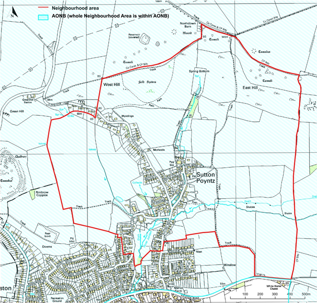
Situated within an Area of Outstanding Natural Beauty (AONB) and including a designated Site of Special Scientific Interest (SSSI), Sutton Poyntz and the surrounding countryside provides a particularly rich and diverse variety of habitat and wildlife species (1, 6, 7, 9) given the semi-urban location and proximity to human habitation. The River Jordan and its feeder streams form a natural Green Corridor (1, 43) which provides an ideal transit route for aquatic and airborne wildlife while the chalk/gravel bed and the banks support a good variety of flora and fauna. The hedgerows (3), trees and limestone walls that spread out across the surrounding landscape provide important connectivity (2, 12, 43) to other green islands of habitat and are supplemented by the sympathetic planting of pollinator species in many residential gardens. The non-intensive use of adjoining farmland acts as a barrier to pollution from field run-off while the relatively low traffic flow limits airborne emissions. The resulting green infrastructure and distribution of priority wildlife species (4) is represented in Maps 12, 13 and 14 (see Annex). These may be used as a secondary source of information in support of the primary source of verified data held by Dorset Environmental Records Centre.
The policies and aspirations in this plan seek to address the potential impact of new development on biodiversity and deal specifically with:
Given the expressed strength of public opinion (11) that biodiversity should be enhanced as well as protected, the policies in this plan seek to both underpin and strengthen the provisions of the Local Plan (14) and place these in a local context.
This policy is designed to ensure that wildlife habitat is enhanced as well as protected to help counteract the impact of global climate change. Protection is particularly critical along the Green Corridor to provide free unhindered movement, although of significant wider importance across the entire Neighbourhood Plan area (43). New developments should wherever possible incorporate wildlife friendly measures such as suitable nesting/roosting sites for declining bird species, bat tiles, hedgehog gaps in fences, planting of indigenous tree and hedge species and of pollinator species in order to enhance biodiversity habitat both within the site and along its boundaries. These considerations are likely to become even more important in the future as global warming will impact many aspects of the environment such as average temperature, soil acidity and moisture levels which will mean whole groups of animals and plants will be on the move seeking the conditions that suit them best.
This policy aims to facilitate the maintenance and improvement of wildlife habitat as part of the green infrastructure through co-operation with developers, landowners and others in liaison with biodiversity organisations. This would build upon projects such as those carried out by the Sutton Poyntz Biodiversity Group in collaboration with Wessex Water plc and the Garden Bird Watch (16) project.
POLICY BNE 1 – PROTECTION AND ENHANCEMENT OF WILDLIFE HABITAT IN RELATION TO NEW DEVELOPMENT.
BNE 1.1 Development proposals that protect or enhance wildlife habitat on-site and along their boundaries will generally be supported.
BNE 1.2 Development proposals will demonstrate that they have sought to protect existing wildlife habitat and should seek opportunities to enhance wildlife habitat and pursue opportunities for securing measurable net gains for biodiversity. Where they fail to address wildlife habitat protection, development proposals will not be supported.
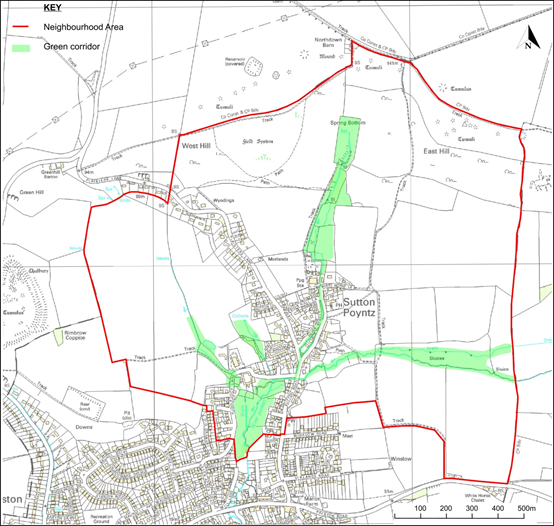
BNE 1.3 Development will not lead to or cause serious risk of environmental harm to the Green Corridor in Sutton Poyntz which follows the River Jordan and its tributaries (and which is defined on Map 2)
BNE 1.4 All development proposals within the area defined as the Green Corridor that meet the requirements of the Dorset Biodiversity Appraisal Protocol, will be expected to include a Biodiversity Appraisal and Biodiversity Mitigation and Environmental Plan.
National Policy Planning Framework (13) paragraph 170, 172, 174, 175 apply.
Local Plan Policies (14) ENV 2 and ENV 3 apply.
MAP 2 – DEFINED GREEN CORRIDOR
Biodiversity has been highlighted as one of the things that people feel makes Sutton Poyntz a special place (10) and it has been identified as one of the best recorded areas of Dorset in terms of wildlife (15) largely due to an active local biodiversity group. The public consultation survey of 2017-2018 (10, 11) identified very strong support for biodiversity conservation and enhancement along with the protection of habitat from inappropriate development through the designation of a Green Corridor and areas of Local Green Space (36). The rationale for the selection of the areas identified within the plan policies is detailed in a separate document (43). It is considered that the overall aims are best achieved through a process of co-operation and collaboration between the various stakeholders underpinned by policies encompassing biodiversity protection and enhancement measures relative to new development. National policy requires that the potential effects of a development on the habitats or species of the Natural Environment and Rural Communities Act 2006 section 41 list (in Biodiversity 2020) must be taken into consideration and a locally derived list is provided (4) as a secondary source to help inform future planning decisions and also to encourage public self-assessment. In support of a policy of enhancement and given the proximity of priority species to potential development within this relatively small Neighbourhood Plan area it is reasonable to extend the application of a Biodiversity Appraisal (15) and Biodiversity Mitigation Plan to proposed developments where the landholding lies within the boundary of the Green Corridor.
The Dorset Biodiversity Appraisal Protocol (DBAP) provides a framework for
quantifying impacts on biodiversity arising from development and setting out the required mitigation and enhancements (net gain) as stipulated in the National Planning Policy Framework 2018, and for compensation as a last resort where there is a residual loss of biodiversity.
The DBAP affects anyone making a planning application which has an impact
on biodiversity and may require an ecological survey by a suitably qualified person prior to applying for planning permission.
Dorset local planning authorities routinely ask for a biodiversity appraisal in the form of a standard Biodiversity Mitigation and Enhancement Plan (BMEP) with accompanying Certificate of Approval to be submitted with a planning application, where the following criteria apply:
Such measures will add considerably to the protection of the diverse range of birds, mammals, fish, herptiles and invertebrates (several rare or endangered) that are found in the area as well as their habitat.
This policy aims to enhance social and environmental benefits by protecting areas of importance to the community in terms of beauty, recreation, wildlife, tranquillity or historic value for both current and future generations and specifically aims to prevent the encroachment of development into those areas. A primary purpose for many of the designated Local Green Spaces is to secure a buffer zone along the Green Corridor as it passes through developed areas to allow wildlife to move freely along the corridor and provide connectivity to potential habitat in adjacent areas (3, 43).
The policy seeks to allow for proportionate development in those special circumstances that would benefit the community, such as for improved recreational facilities, agricultural and horticultural use, or operations related to statutory undertakings, with the condition that they do not compromise the added value of the designation.
The implications of Local Green Space designation are that whilst a site’s development opportunities are restricted, nothing else about the site is altered. In particular, it does not alter who owns or manages a site, who has right of access to a site and it does not preclude incidental site changes that do not require planning permission e.g. erecting a shed or creating a pond (37). Neither does the designation reflect upon the stewardship of the land and in fact demonstrates the desire of the community to build stronger relationships in support of the continued care of these important and valued areas.
The policy is not intended to impede the operational needs of bodies such as Wessex Water who have statutory duties related to the provision and protection of public water supply and is indeed seen to be complementary to those functions and the organisations’ vision for sustainability (48).
POLICY BNE 2 – LOCAL GREEN SPACES
The sites shown on Maps 3a and 3b are designated as Local Green Spaces and afforded additional protection due to their demonstrable value to the local community in terms of their recreation or beauty or wildlife or historic value.
National Policy Planning Framework (13) paragraphs 99,100,101 apply.
Local Plan Policies (14) ENV 3 and COM 5 apply.
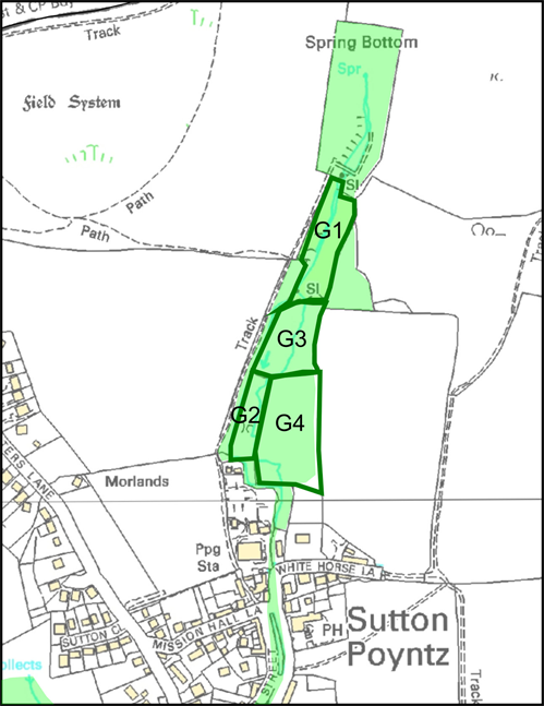
MAP 3a – AREAS OF DESIGNATED LOCAL GREEN SPACE G1 to G4
| KEY TO MAPS 3a & 3b OF AREAS TO BE DESIGNATED AS LOCAL GREEN SPACES | ||||||
| Map Ref | Approx. Site size (hectares) |
Description | Key values/reasons for Local Green Space designation. | |||
| Beauty | Wildlife | Recreation | Historic | |||
| G1 | 0.65 | Wet Woodland | Yes | Yes | Yes | No |
| G2 | 0.34 | Veterans Wood | Yes | Yes | Yes | No |
| G3 | 0.52 | Area of Fen | Yes | Yes | Yes | No |
| G4 | 0.85 | Water Meadow | Yes | Yes | Yes | Yes |
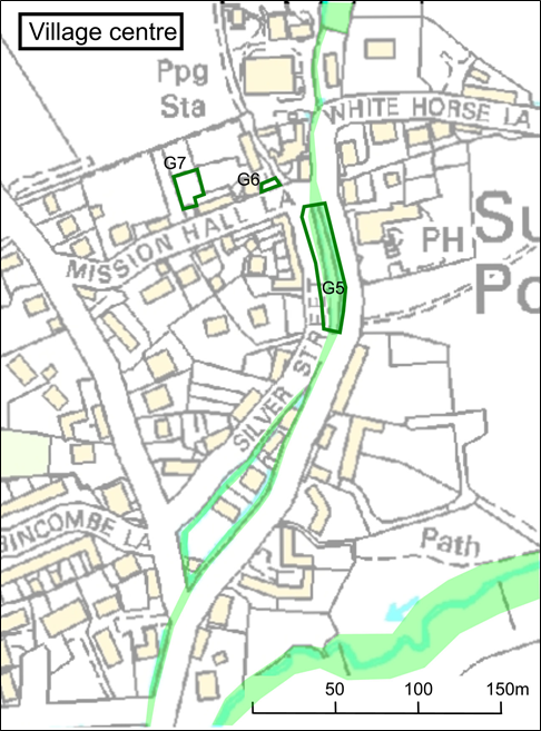
| G5 | 0.08 | Mill Pond | Yes | Yes | Yes | Yes |
| G6 | 0.01 | Village Green | Yes | No | Yes | Yes |
| G7 | 0.02 | Mission Hall Orchard | No | Yes | Yes | Yes |
MAP 3b – AREAS OF DESIGNATED LOCAL GREEN SPACE G5 to G7
The areas identified meet the National Planning Policy Framework (NPPF) criteria (13) for designation of Local Green Space and have been professionally and independently assessed (37) and subject to consultation with affected landowners. Most of these spaces are adjacent to the Green Corridor and in addition to amenity value provide strong interconnectivity for wildlife transit between habitats, particularly priority species (4). Extraction of water from the River Jordan has continued for over 150 years and is a key part of the village heritage; this designation provides an opportunity for the whole community to extend the partnership with Wessex Water and create new partnerships as we seek to build the green infrastructure together around this natural resource. The supporting rationale for the choice of the sites and their inter-relationship with the green infrastructure and other designated protections within the neighbourhood area is detailed in a separate document (43). Very strong public support exists for the identification of designated Local Green Space within the Neighbourhood Plan area (36).
Trees and hedges add to the character of the landscape – see trees and hedges sub-section for each of the five character areas in section 5 of the Place Appraisal (1). They provide important amenity value and essential wildlife habitat and help to mitigate the effects of climate change. However, inappropriately located and unmanaged trees can present problems such as reduced light or visibility, damage from falling or root growth and fouling of overhead service cables. This policy opposes the unnecessary destruction of trees and hedges caused by land development and gives priority to the preservation of native and locally indigenous species (for example but not limited to Hazel, Ash, Field Maple, Pendunculate Oak, Wayfaring Tree, Crab Apple, Blackthorn and Hawthorn), individual or groups of trees assessed for their amenity value, veteran trees, traditional orchards and those of historical importance. Where there is no alternative to removal the replacement with suitably sited indigenous trees will ensure that the distinctive character of the area is maintained (1) whilst minimising problems associated with natural growth. Enforcement of these provisions shall be through the inclusion of a condition to the planning consent. Dispensation shall be given where it can be clearly demonstrated that a replacement tree would be inappropriate.
POLICY BNE 3 – TREE PRESERVATION
Development proposals should retain and protect existing trees and hedges which contribute to the distinctive character (1) of the Neighbourhood Plan area or which contribute biodiversity value to the area.
Where there is no practical alternative to the removal of such a tree it will be replaced with an indigenous species of a type appropriate to the location.
National Policy Planning Framework (13) paragraphs 125, 170 and 175 apply.
Local Plan Policies (14) ENV 2 and ENV 10 apply.
Strong public support has been demonstrated for the preservation of managed trees and hedges (8, 11, 36). The Neighbourhood Plan area contains several important trees and hedges including veteran trees, historic field boundaries and traditional orchards that are recorded in several sources (1,3,4,7,15 and Map 13 in the Annex).
Note: No specific policies have been developed and it is intended to take the following forward as aspirations for the community.
To support opportunities for the small-scale development of business and services, local employment and tourism by supporting those home improvements which enable low key home working and encouraging community led projects.
Sutton Poyntz has its origins as a small farming community where employment was primarily based on agriculture and the supporting services and, later, water supply. This theme of community based employment is reflected in the modern day where the Springhead Pub is now the major employer and many people have low key home based businesses such as consultancy, blacksmiths and horticulture.
The community has expressed support for maintaining this type of business (36) which is well suited to what is an otherwise residential location. Sutton Poyntz is also situated close to Weymouth with its wider employment opportunities including those associated with the local tourism industry. The community has identified several aspirations in relation to low key home based employment and the potential for the provision of a small village shop, such as a pop-up facility.
From a tourism perspective, the village remains popular for those visitors seeking solitude away from the hustle and bustle of Weymouth and there is support for the enhancement of the small scale non-commercial tourism that has characterised the village in the recent past (1) in addition to the provision of guided visits (36)
Since the first public consultation (10), telecommunications providers have improved the local infrastructure which has resulted in increased satisfaction levels. In the subsequent public consultation (11,36), 92% of respondents found mobile phone reception to be between variable and excellent, 74% found the speed of their internet to be satisfactory or better and 79% found their internet reliability to be satisfactory or better. Given the focus nationally is to increase speed and reliability in locations where it is poor or non-existent, an aspiration rather than a policy is appropriate.
Promote and develop a safe, accessible, reliable and environmentally friendly transport network by providing a choice of pedestrian and public and private vehicular transport options with emphasis on reducing the impact of car usage.
Despite its semi-isolated location, the population of Sutton Poyntz benefits from proximity to the towns of Weymouth and Dorchester for public and private transport links (1). Private motor vehicles are the most popular means of accessing the area and increasingly bring with them road safety concerns, atmospheric pollution, congestion, impaired public service access and erosion of infrastructure. The policies in this plan seek to address these issues relative to future development and deal specifically with:
Specific community aspirations in relation to public bus services; public footpaths and traffic control are identified in section 5.3 and are to be pursued through the relevant authorities.
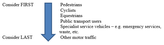
The policy aims to establish a clear order of priority for the safe movement of people in relation to various transport options when planning for new development and ensure that safe access is not compromised. Examples include; suitable means of access such as slopes as opposed to steps and accessible pedestrian short cuts to bus stops and other public rights of way.
This approach aligns with the hierarchy of road users as identified in section 6.5.5 of the Local Plan (14).
The policy aims to ensure that means of access are both safe and designed to be in keeping with the character of the area. For example, street lighting shall be of a type that provides sufficient downward illumination without creating excessive light pollution and pedestrian walkways shall provide sufficient segregation without the necessity for raised pavements.
POLICY GA1 – TRANSPORT NEEDS AND NEW DEVELOPMENT
Any new development that generates additional traffic flow should:
GA1.1 Seek to minimise dependency on private car usage.
GA1.2 Apply the hierarchy of road users to identify suitable access routes
GA1.3 Where it forms part of the development, include street lighting of a suitable type and footways so designed as to retain the character of the immediate surrounding area.
GA1.4 Provide suitable access links to existing pedestrian and cycle routes where such opportunities exist.
National Policy Planning Framework (13) paragraph 91, 102, 104(d), 108, 110 apply. Local Plan Policies (14) COM 7 and ENV 11 apply.
Future development must consider the strong support (10) for ease of access to a maintained network of public footpaths that criss-cross the surrounding countryside and which provide important leisure, amenity and service access for locals and visitors [see 5.3.2]. The desire of the community (11, 36) to retain the character of the rural lanes and not incorporate raised pavements into new developments needs to be balanced against the road safety issues arising from an absence of footways on the main access roads and the erosion of public footpaths by motorised traffic (10) such as on Puddledock Lane. In terms of road safety and personal security the community have expressed support (36) for a policy of incorporating adequate street lighting into all new developments where it forms part of the planning proposal.
This policy aims to address the concerns associated with increasing on-street traffic congestion including that arising from business expansion where additional visitor parking demand occurs. It aims to reduce the detrimental impact, in terms of amenity and emergency/public service access, of on-street vehicle parking in the narrow lanes by creating greater off-street parking choices which take into account aesthetic impact and local character (1) at the design stage.
POLICY GA2 - ON-STREET TRAFFIC CONGESTION
GA2.1 Development proposals that do not comply as a minimum with the off-street parking criteria contained within the Bournemouth Poole and Dorset Car Parking Study will not be supported.
GA2.2 Any development will be designed to discourage additional on-street parking on the existing road network, especially near junctions or where the road is narrow.
National Policy Planning Framework (13) paragraphs 102, 105, 106, 110 apply. Local Plan Policy (14) COM 9 applies.
Car ownership is relatively high at 89% of households with 46% of households owning at least two vehicles (1). This creates increasing congestion from on-street parking (11, 19, 36) on the narrow access roads, particularly the Sutton Road ‘gateway’ and around the village pond and a policy is needed to ease these pressures. The decline in the village bus service since 2013 from 11 buses per day to the current 3 has resulted in greater use of car transport due to the inconvenient frequency and poor reliability of the service (1, 23). Due to the higher levels of car ownership (18.6% higher than Weymouth (1)) the guidelines for the number of visitor spaces per house in new developments and resident parking space criteria should become a mandatory requirement to reflect the higher than average levels of multiple vehicle ownership (1).
The edge of town location of the Sutton Poyntz beauty spot within an Area of Outstanding Natural Beauty attracts visitors from near and far for leisure and recreation purposes (1) and this creates additional on-street parking congestion around the village centre (11, 19) which is further exacerbated by the volume of traffic visiting the popular Springhead Pub with its limited parking capacity.
The community has expressed concerns (10) regarding the speed of vehicles (20) on the narrow lanes that do not have pedestrian footways and the desire to see a reduction in speed through the application of measures that are non-obtrusive (11,19,36) and not detrimental to the sense of place (1).
Policy GA3 seeks to introduce measures to mitigate the post development erosion of infrastructure by larger vehicles and increasing traffic flow (19, 20) and expresses support for those development proposals that incorporate mitigating measures to address these issues at the design stage. The policy also seeks to address the issue of increased traffic size and volumes entering and leaving new development via minor through roads that are progressively unable to cope with such demand during the construction phase.
POLICY GA 3 – IMPACT OF TRAFFIC DENSITY ON CURRENT INFRASTRUCTURE
Proposals for new or improved transport infrastructure will be supported.
National Policy Planning Framework (13) paragraphs 91, 102, 104, 108, 110 apply. Local Plan Policies (14) COM 1, COM 7 and ENV 11 apply.
Increasing traffic volumes have long been of concern to resident’s (19) and a perceived increase in the speed of through traffic has resulted in calls for a 20mph speed limit in a recent survey (10). Vehicle monitoring data (20) shows that the average speed of vehicles along Plaisters Lane is 20.9 mph with a maximum speed in the region of 35 mph. Although this does not meet the criteria for a more rigorous enforceable speed restriction (24) than the current 30mph limit, other measures need to be considered to address these concerns. Past residential development has resulted in a detrimental impact on the narrow lanes and footpaths due to erosion by the increased volume, speed and size of vehicular traffic (10, 19) and this needs to be addressed.
The policy addresses the environmental issues associated with pollution from internal combustion engines and aims to promote greater use of low emission vehicles which bring benefits of improved air quality.
POLICY GA 4 – POLLUTION REDUCTION
The provision of adequate ultra-low emission vehicle charging facilities for all new residential units will be supported.
National Policy Planning Framework (13) paragraph 105(e),108 and 110(e) apply.
Local Plan Policy (14) COM 7 and COM 9 apply.
This policy makes provision at the design stage for adequate electric vehicle charging
points to be integrated into vehicle parking spaces in all new build development; a proposal which has received significant majority public support in a recent survey (11, 36). This will help to ensure that new properties are designed ready for the planned switchover from fossil fuel, in line with UK Government policy, as set out in its ‘Road to Zero Strategy’.
To improve understanding of the heritage in and around our village, and thereby:
Sutton Poyntz lies in an area extremely rich in prehistory and has its share of more recent treasures. A Working Paper (31) has been prepared as background to this Neighbourhood Plan document, building on a number of sources.
Map 4 in the Place Appraisal (1) is a summary of Listed Buildings (28) and Monuments (26). They comprise four main groups:
What makes Sutton Poyntz special?
The historic core of the village mainly hugged the right bank of the River Jordan and contains all the Listed Buildings although other more recent buildings outside the core have heritage significance. This is the area that visitors come to enjoy, but there are some locations that are of particular importance:
Several unlisted buildings and built features (27) within the village core are evidently of some age; many of these provide context to the Listed Buildings (28). Outside the core, there are a scattering of older dwellings that are not listed, as well as a group of 1930’s houses, mainly but not all designed by E Wamsley Lewis (founding President of the Weymouth Civic Society), that sought to recreate a rural style using local materials.
Protection of Heritage
To protect this area of high archaeological potential, we propose a Policy that we believe comes closer to the spirit of the National Planning Policy Framework (13) than the current Local Plan (14).
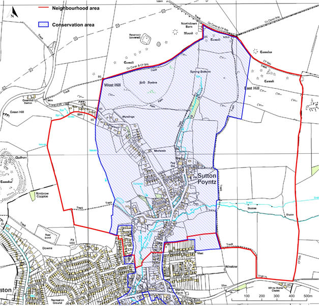
The protection of built Heritage for the Neighbourhood has proved more difficult to achieve, as it relies on the Local Planning Authority to commit resources to provide better definition of the significance of our heritage than is currently available. Most of the village of Sutton Poyntz is in the Sutton Poyntz Conservation Area (which also includes some historic areas of Preston); however, the current Conservation Area Appraisal (30) lacks detail and has no Management Plan. We have therefore defined two Community Aspirations: ideally, we would like a better Conservation Area Appraisal to be written for the Sutton Poyntz Conservation Area, to include a Local List identifying heritage assets of local importance; failing that, as a backstop arrangement, we would like the Local Authority to produce a Local List of heritage assets for the Sutton Poyntz Neighbourhood area.
To assist the Local Planning Authority, as part of the Neighbourhood Planning Process we have commissioned a Heritage Report (47), with evidence and assessments relating to a provisional list of heritage assets of local importance. This is offered as input to the Local Authority in its task of preparing a final list; the document has already been the subject of local consultation and review, and correspondence and minutes of meetings with householders will also be supplied.
This Policy is intended to ensure that important archaeology is not destroyed unwittingly, and that less important heritage can be identified and recorded before it is destroyed.
The words “on previously undeveloped land” are intended to apply to planning applications that break significant new ground; so, for example we would not expect a proposal for a minor extension of an existing dwelling to always require an archaeological assessment, but we would expect this Policy to apply to a second dwelling within an existing plot, or to development of a new plot.
POLICY HE 1 – PROTECTING ARCHAEOLOGY
Development proposals on previously undeveloped land should be accompanied by the results of an archaeological assessment of the development site.
National Planning Policy Framework (13) paragraphs 189 and 199 apply Local Plan Policy ENV4 (14) and its preamble applies.
All of the developed part of the Neighbourhood Area, along with the fields abutting the developed area, lie within an area designated in the Local Plan as of “Archaeological Potential"; the current Local Plan ((14) paragraph 2.3.8) states that an archaeological assessment “may be required” for development in such areas. Given that the developed area of Sutton Poyntz is closely ringed by ‘Monuments’ listed in the Dorset Historic Environment Record (see Map 4), an archaeological assessment should be the norm. This would provide a policy that is closely aligned with NPPF (13) paragraph 128.
MAP 4 – EXTRACT FROM DORSET EXPLORER MAP (29) SHOWING KNOWN ‘MONUMENTS’ AROUND VILLAGE CENTRE
Sutton Poyntz is a relatively small settlement. It lies within the Dorset Area of Outstanding Natural Beauty (AONB) and has a Defined Development Boundary which preserves the green gap between Preston and Sutton Poyntz. The village is covered in its entirety by a conservation area. These factors constrain development opportunities within the village.
The Neighbourhood Plan area does not contain any existing allocation sites in the Local Plan (14) – although there are substantial sites nearby, in and around Weymouth. This Neighbourhood Plan does not allocate particular sites for new housing development; however, incremental growth is desirable and there is an expectation that new dwellings will be built over the plan period at the same rate as the last twenty years. This is most likely to be delivered through infill development or increasing density on some sites within the existing Defined Development Boundary.
The possibility of small-scale exceptions is noted, as long as they match the requirements of Local Plan (14) policy HOUS2 (on rural exception sites to meet identified local need), subject to sustainability. Should the rate of development in the Neighbourhood Plan area fall significantly behind that expected, the intention would be to review the Neighbourhood Plan to explore other options in consultation with the Local Authority.
This policy aims to ensure that all future building adds to the character of Sutton Poyntz, does not detract from the AONB and ensures that the new properties are of a character appropriate to their surroundings. A balance is sought between traditional and contemporary design which brings greater coherency to the village’s built environment and which reflects its history and heritage.
MAP 5 – AREA WITHIN DORSET AONB
Design Guidance
The Conservation area is shown on the map below; this shows that almost the entire village lies within the Conservation Area. There is no narrative or management plan for the Conservation Area and so policy H&P 1 aims to give guidance on style and design to aid future planning decisions.
MAP 6 - SUTTON POYNTZ CONSERVATION AREA
In general, any developments must be sympathetic to the local character and history of the village, including the built environment and landscape setting, whilst not preventing or discouraging appropriate change such as increased densities. Whatever the location, good quality design and sympathetic use of materials are essential. Contemporary or innovative design will be considered in those areas outside of the historic core where it is of high quality and does not detract from the immediate surroundings.
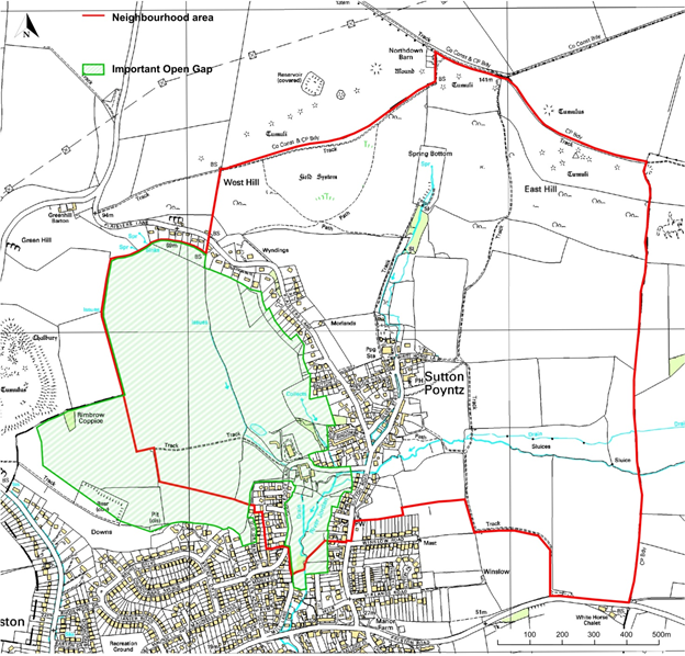
MAP 7 – IMPORTANT OPEN GAP (defined in Local Plan)
Our policy is for new building to reflect surrounding properties where the design enhances the area. Where surrounding houses are not of traditional or sympathetic design, they should reflect the older properties in the Historic Core and as described in the Place Appraisal. This notes that older dwellings are built mainly of Portland stone rubble and occasionally local stone, under both thatch and slate roofs. The use of these materials will be encouraged on new houses, as appropriate and depending upon their location.
More recent buildings have used guillotined Purbeck stone, in some cases with dressed quoins and corbels. We would encourage the use of similar materials in new homes where possible. We would also support the use of mellow or soft red brick, which appears on old as well as new properties.
On some new properties, effective use has been made of reclaimed materials (e.g. tiles) suggesting their former agricultural purpose and this approach is to be encouraged. Reconstituted or sawn stone would be discouraged as would tumbled stone with rounded edges. Roof pitches and heights should be sympathetic to nearby properties and sit comfortably in the existing street or lane scene. Flat roof developments, including extensions, are out of character for the village and are therefore inappropriate.
Stone boundary walls appear throughout the character areas and their appearance is important. The traditional style known as ‘Cock and Hen’ with brushed out lime pointing will be supported for new developments. Red brick and coping as a main walling material will be discouraged. Tree planting schemes that are sensitive to views will be encouraged to soften new development boundaries.
The Dorset AONB 2014-19 Management Plan Policy Framework 4A .1 (35) states that the sensitive siting and design of development is vital to conserve and enhance the landscape and scenic beauty of the AONB. The above guidance aims to ensure this for all future building works, including extensions and alterations, thereby adding to the character of the village and not detracting from the AONB (34).
POLICY H&P 1 – BUILDING STYLE AND DESIGN
H&P1.1 Development will seek to preserve or enhance the character or appearance of the Conservation Area, taking account of traditional building style or materials.
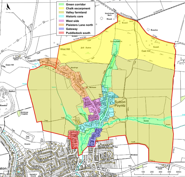
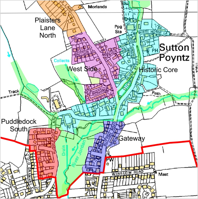
H&P1.2 Subject to H&P1.4 below, new development within the village should take account of nearby building style and materials, as described for five defined character areas which have their own design guidance described in the accompanying text below. The five character areas, shown on Maps 8/8a, are:
H&P1.3 New development and extensions or alterations to existing buildings will not detract from the local character of the AONB.
H&P1.4 Development will be supported which enhances the character and appearance of the village at locations where existing development has not been in a style that is complementary or sympathetic to the area’s traditional building styles.
National Planning Policy Framework (13) paragraphs 124, 125, 126, 127, 130 and 200 apply.
Local Plan Policy ENV 1 ,4, 10 and 12 (14) apply.
In summary, building works are to be of a nature and character appropriate to their surroundings. All aspects of the design of new properties both traditional and contemporary should enhance the local character of existing dwellings, streets and lanes. Preference will be given to designs and materials that resonate with, but do not necessarily replicate the style of the older more traditional properties in the village, while at the same time taking advantage of modern building methods and energy efficient materials.
A Place Appraisal (1) has been produced as part of the process of creating this Neighbourhood Plan which defines these five character areas and describes their distinctive features. The Stage Two survey gave significant support for new development taking greater account of nearby building design (36). This significant community response underlines Policy H&P 1 and emphasises the important role of this measure in meeting the aspirations of the community to improve and enhance their environment.
Dorset AONB 2014-19 Management Plan Policy framework 4A.1 (35) states that the sensitive siting and design of development is vital to conserve and enhance the landscape and scenic beauty of the AONB.
MAP 8 - VILLAGE CHARACTER AREAS
MAP 8a - VILLAGE CHARACTER AREAS (Expanded view)
Village Character Areas
The Sutton Poyntz Place Appraisal (1) identifies five character areas within the village, these are:
These descriptions along with the map showing the character areas are taken directly from the Place Appraisal (1).
This policy aims to ensure that any development is incremental, and this is expected to happen through infill and possibly increased density.
This development will be delivered through Local Plan policies, which H&P2 supports. Should the rate of development fall significantly behind that expected, the intention would be to review the Neighbourhood Plan to explore other options in consultation with the Local Authority
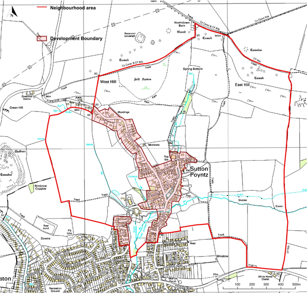
MAP 9 – DEFINED DEVELOPMENT BOUNDARY (within Neighbourhood Area only)
POLICY H& P 2 - HOUSING NUMBERS AND SIZE
H&P2.1 New residential development within the defined development boundary will normally be supported. This will lead to higher density and smaller homes within the defined development boundary.
H&P2.2 There is a preference for smaller (2 or 3 bedroom) homes to meet local needs. These include providing for families, for older residents wishing to downsize, and for young people wishing to continue living in the neighbourhood.
National Planning Policy Framework (13) paragraphs 61, 62, 67, 68(c), 117, 118, 122 and 172 apply.
Local Plan Policy SUS 2 and 5, ENV15 and HOUS 3 (14) apply.
This Neighbourhood Plan is not an allocation plan. It looks to policies in the Local Plan to deliver new housing. However, over the last 20 years approximately 20 new homes have been built in the village and so a similar number seems appropriate.
The Stage Two survey (36) showed substantial support for between 10 and 20 new homes in the village. National planning guidance is that neighbourhood plans should support more new homes and so our expectation reflects this - using the higher end of the figures suggested by the survey.
The village has limited public transport, employment opportunities within the village are small and most residents rely on their own transport to get to work and access public services. Sustainability (32, 34) is therefore an area of concern and a reason behind the modest numbers being proposed. If we can maintain the historical rate of around one property per annum this should not create sustainability issues.
New housing involving replacement of existing dwellings to provide smaller scale housing, if necessary, at higher density will be supported, as will houses of a higher specification suitable as retirement homes that will encourage residents to downsize, releasing larger homes for families. This includes change of use and development of gardens where appropriate.
Identifying these important views means that those views can be protected from unsympathetic development. The AONB policies do not preclude development within the sweep of existing views; they state that any development should be complementary.
This policy is to ensure that these seven important views are preserved, and any development does not detract from them. It recognises, in line with AONB policy, that some development can improve key views
POLICY H&P 3 – KEY VIEWS
H&P 3.1 The following views into, out of and within the village are designated as Key Views:
H&P 3.2 New development should respect the key views. Any development which would obstruct or significantly detract from them will not be supported.
National Planning Policy Framework (13) paragraph 170, 172, 185 applies.
Local Plan Policy ENV 1 and ENV 10 (14) apply.
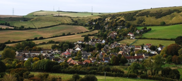
The village sits under the South Dorset Ridgway and its setting within the landscape is a key part of its character. There are several iconic views within the historic village and outward towards the much-loved nearby hills.
Dorset AONB 2014-19 Management Plan Policy framework 4A.1 (35) states that the sensitive siting and design of development is vital to conserve and enhance the landscape and the scenic beauty of the AONB.
An independent survey (38) identifying important views was carried out and which identified 15 views that might be suitable for designation. These were reviewed by the Housing and Planning Sub-Group and ratified by the Steering Group who recognised that in a village of the size of Sutton Poyntz, 15 views were probably excessive and so only the iconic views were selected. These 7 views are shown in Maps 10/10a below.
NB: We acknowledge that views 4, 5, 6 and 7 are expansive vistas, essentially views that set the village in its context nestling below the South Dorest Ridgeway in walking distance from the coast. These views should be used as a guide so that any development in the village does not jar or draw the eye from the setting. The photographs of these views include arrows to show the key parts of each view.
MAP 10 - KEY VIEWS OF VILLAGE FROM SURROUNDING COUNTRYSIDE
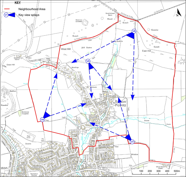
MAP 10a – KEY VIEWS WITHIN OR OUT FROM THE VILLAGE
Photographs and Description of Key Views
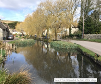
View 1 the iconic view of the village’s Mill Pond.
This view is considered important as it captures the essence of the village; it is the classic picture postcard view which includes the key characteristics of Sutton Poyntz. No development that detracts from this vista will be allowed.
View 2 from the Mill Pond towards White Horse Hill, the view from the heart of the village.
This view gives a feeling of openness and connection to the hills beyond the village and is important as a backdrop to the Mill Pond which is the heart of the village. Any development in this area would detract from the centre of the village and remove its rural feel, this field and beyond towards White Horse Hill should remain as open space.
View 3 the sweep down from the Sutton Poyntz stone towards the junction outside the Cart Shed.
The view of the South Dorset Ridgeway and White Horse Hill has been partially obscured by infill development in the gateway to the village. Any future development will retain the narrow lane and protect the residual views.

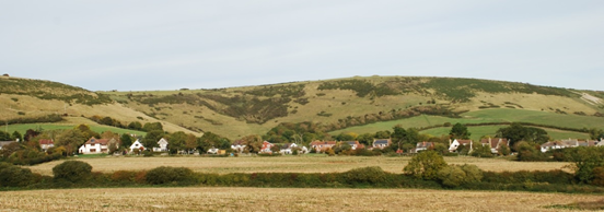
View 4 North from path below Chalbury.
This view is important because it is framed by the houses on the hill running up Plaisters Lane. Any development in and around those existing houses should not stand out from the neighbouring properties and should not detract from this view.
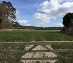
View 5 From the Beacon below West Hill
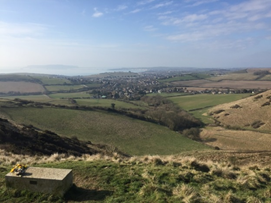
This view is an important one for the village. There is a seat for walkers, and this is a regular viewing point for those approaching the village on foot. It encompasses the whole village. Any development that can be seen from this point must enhance the AONB and reflect the traditional building styles within the village.
![]()
View 6 From Margaret's Seat above Spring Bottom.
Another important view for those approaching on foot. It encompasses the whole village and sets it in the landscape with the view of the sea in the distance. As for view 5 any development that can be seen from this point must enhance the AONB and reflect the traditional building styles within the village.
View 7 From Winslow on the footpath just on village boundary.
This was seen as a particularly important view by the independent assessor. It encompasses the whole village and sets it in the landscape with the South Dorset Ridgeway beyond. Again, any development that can be seen from this point must enhance the AONB and reflect the traditional building styles within the village.
The plan recognises that some developments can enhance key views, so the policy is not to stop any development on land visible from the identified viewpoints but to ensure any development enhances the existing vistas.
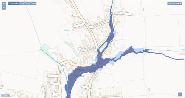
Since the risk of flooding is already high and is predicted to get worse a policy is required that adopts pro-active measures that ensure that the rate and volume of surface water run-off from a developed or re-developed site onto the surrounding land and roadways is no greater than from the undeveloped site (42). Due to the expected periods of heavy rainfall in the future because of climate change, it is important to utilise measures to retain a greater volume of surface water on-site rather than simply diverting it towards neighbouring land or homes and therefore in the short term to reduce run-off wherever possible. The policy is intended to apply to all development proposals in the Neighbourhood Plan area as any potential surface water run-off is likely to flow into the higher risk flood zones given the local topography.
New development proposals must include information which explains how the volume and rate of surface water run-off will be reduced or mitigated, for example by the inclusion of soakaways or porous driveways such that surface water run-off will be absorbed by the natural water course system on the site (42). Useful guidance on a range of effective low cost solutions has been produced by Dorset County Council (45) and is supported.
Policy H&P 4 - FLOOD PREVENTION
Development proposals will be required to make use of sustainable drainage design features including porous (permeable) surfaces and demonstrate that the volume and rate of surface water run-off onto adjacent land and traffic routes is either at a lower or equal level to that prior to the development.
National Policy Planning Framework (13) paragraphs 149, 155, 156, 157, 159, 160, 163, 164, 165 apply.
Local Plan Policy (14) ENV 5 applies.
Flooding events have not been uncommon in the past, major flooding events having occurred in Sutton Poyntz and Preston in 1955, 1977, 1979, 1983, 1993 and 2003 (44). Most recently in 2012 and 2014, after a period of very heavy rainfall, the River Jordan overtopped its banks and resulted in the flooding of cottages adjacent to the village pond.
The foul sewer in Plaisters Lane has frequently suffered uncontrolled overflows onto the highway and private property. Despite the excess overflow outlet into the River Jordan the sewer also overflows in the valley leading to Osmington as the system is unable to cope with both foul effluent and surface water run-off present in the foul sewer. Consequently, flooding of gardens and the road at the junction of Puddledock Lane and Sutton Road and opposite Old Bincombe Lane is a common occurrence in periods of high rainfall.
There is a higher than average number of properties with long wide driveways, particularly to the north of the Environment Agency Zone 3 (high risk) flood area. This situation is further accentuated by the higher than average level of multiple vehicle ownership (1) with consequent demand for hardstanding, together with the location of most of these properties on a steep gradient which receives a higher than normal flow of surface water from natural spring sources in the surrounding hills.
The steep hills to the north of Sutton Poyntz mean that after only short periods of intense rain the increase in the flow of the River Jordan leads to scouring of the chalk river bed and loss of flora and fauna. For example, a mass of Water Crowfoot once thrived in the river opposite the Cartshed and provided habitat for invertebrates as well as food and cover for water voles which had burrows in the banks of Osmington Brook. The Water Crowfoot has declined significantly which also coincided with the end of reported sightings of water vole in the stream in the immediate area and along the Osmington Brook.
The Environment Agency identified much of Sutton Poyntz’s historic core to be at a high risk of flooding. To improve the position, it therefore undertook extensive work designated the “River Jordan Alleviation Scheme”. This work near Fisherbridge, “aims to provide flood protection to a maximum 1 in 100-year standard of protection.” (46)
The UK Climate Change Projections (UKCP09) state that “River flood flows are projected to increase by 20% by 2050, and 30% by the 2080s. The increase in flows are likely to be seasonal, with an increase in winter of up to 20%, but a decrease for the rest of the year, particularly in the summer where flows could be reduced by 50 to 80% in some instances by 2050. Extreme rainfall intensity is likely to increase by 10% by the 2050’s and 20% by the 2080’s” (41). As a result, river flows, and hence heights, will be more volatile in the future and there is the potential for an increase in the number of dwellings at risk of flooding. To help avoid this and align with the Environment Agency projection of a 1 in 100 year event an increase in the amount of surface water runoff arising from within the village should be avoided and ideally reduced. Hence, where practicable, steps need to be taken to ensure that for new developments surface water is retained and managed on site before entering the water course (42). In a recent survey (11) over 90% of residents supported a policy whereby all new developments will be required to be planned to minimise additional surface water runoff.
MAP 11 - FLOOD RISK MAP FOR SUTTON POYNTZ
Key: Dark Blue Shaded Area = High Risk (Environment Agency Zone 3);
Light Blue Shaded Area = Low to Medium Risk (Environment Agency Zone 2)
Sutton Poyntz is a small but vibrant community which has many active interest groups (history, arts, social, etc.) as well as community centred events such as the biennial Sutton Poyntz Street Fayre and monthly coffee mornings. Residents recognise the real benefits that this brings in terms of community cohesion but also appreciate the challenges and areas for improvement that exist (1, 10). For example, there are no indoor or outdoor sports facilities without travelling into Weymouth or Dorchester. The policies in this plan seek to address these issues relative to future development and deal specifically with:
Specific community aspirations have been identified regarding assets of community value, interim arrangements for a children’s play area, history/nature trails and recreational use of the public rights of way, better utilisation of the waterworks museum and provision of additional community facilities.
This policy aims to recognise those facilities of recreational value to the community that are of importance, such that their loss would have a significant detrimental impact on the sustainability of the village and the social well-being of residents. These sites are identified as priorities for protection from planning applications that propose a change of use or do not seek to develop them for the benefit of community provision.
POLICY SR 1 – PROTECTION OF COMMUNITY ASSETS
SR 1.1 Development proposals which would result in the loss of the following buildings as community assets in Sutton Poyntz will not normally be supported.
SR 1.2 Change of use of these facilities will only be supported where it has been clearly demonstrated that:
SR 1.3 Proposals designed to modernise or extend community facilities for public use, including increasing their capacity, will generally be supported.
National Policy Planning Framework (13) paragraphs 91 and 92 (c) apply.
Local Plan Policies (14) COM 2 and 3 apply.
A recent consultation exercise (11, 36) has identified the above facilities as being of
significant value to the community, in each case with over 90% support. These facilities have received consistent recognition as being vital to the sustainability of the community in previous surveys (10) and provide key social and amenity benefits to all. Loss of any of these facilities would have a significant detrimental impact on the community and, in many cases, create social isolation. Strong support has also been expressed for the community value of the Waterworks Museum, however, after consultation with Wessex Water it was felt that formal designation as an asset of community value within an operational water extraction site would be inappropriate. Wessex Water is urged to work with the village to maintain the museum, possibly by employing community volunteers.
Concerns relating to the lack of provision of facilities for younger people have been a consistent theme in earlier village surveys (10, 19) and the need to attract families to the village is recognised. The lack of recreation facilities, particularly for younger children is a disincentive for families with children to choose to live in the village and needs to be addressed in terms of community sustainability. It has been suggested that the use of the small play facility at the Springhead Pub be adopted subject to agreement with the tenants and owners and this would also provide a suitable area for a longer term permanent public facility.
POLICY SR 2 – ENHANCEMENT OF COMMUNITY RECREATION FACILITIES.
Proposals to use land within, or adjacent to the historic centre of the village
for recreational purposes, such as a public children’s play area, will be supported.
National Policy Planning Framework (13) paragraph 91, 92 (a), 96 applies.
Local Plan Policy (14) COM 4 applies.
The mixed opinions expressed in the first public consultation regarding a sports field and a children’s play area (10) resulted in specific questions being asked in the Stage Two Survey (11). The results (36) show public support for some facilities and not for others, and the former have been incorporated into this Neighbourhood Plan. A small majority favoured the provision of a children’s play area with several respondents identifying the Springhead Pub garden as a logical location. There was also a good level of support for a village green and community allotments and these proposed new facilities have been included as aspirations for the community.
< Previous | ^ Top | Next >