
Puddletown will be a well-connected and pedestrian safe village, with public footpaths, bridleways and cycle ways designed to provide a choice of inter-connecting routes within the village and beyond, and roads designed to ensure that traffic speed is maintained at a safe level and there is sufficient public and private car parking to avoid associated parking problems. |
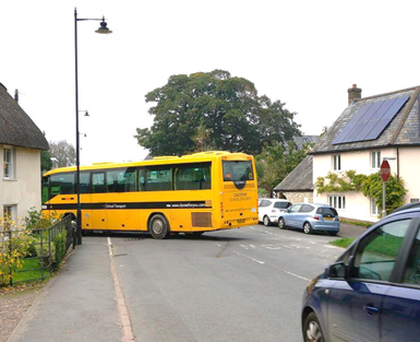
7.1.1 Traffic and safety on the local roads are a concern for residents of Puddletown. The two main routes through the village – the High Street and, to a lesser extent, Blandford Road – have significant levels of traffic, particularly at school drop-off and pick-up times when there are a number of large school buses that travel in from the surrounding villages. At these times the parking along the High Street (particularly outside the shop) can add to the sense of congestion as there is insufficient room for vehicles to pass because of the parked cars. There is a local understanding that New Street and Coombe Road operate as a ‘one way’ system at these times, as they are too narrow to allow two vehicles to pass. Even so, the buses often have to reverse and turn in Butt Close.
7.1.2 Parked cars can also reduce visibility for vehicles exiting from the side roads – this is particularly noticeable by The Green where there are a number of junctions in close proximity, and by the First School (not helped by parents who park their cars on the double yellow lines, in dedicated bus stops, as well as in Greenacres and along Three Lanes End). The parking situation in the housing estates around Butt Close and Beech Road is also of growing concern where the increasing number of vehicles parking on the road can occasionally block the passage of larger vehicles, including waste collection and emergency services. Whilst many properties have dedicated parking areas, there are either insufficient spaces or the spaces are not conveniently located to people’s homes to use. These problems can be exacerbated further by the impact of construction traffic on the surrounding highway network.
7.1.3 Speeding is also a local issue – the parish minutes record a survey in November 2013 that showed 2 in 5 drivers travelling in excess of 35mph (and the average speed throughout the week was just over 34mph). In 2019 a decision was taken to establish a Community Speedwatch, following on from the installation of a mobile Speed Indication Device (shared between Puddletown and Tolpuddle). In October 2019 this recorded 1 in 4 drivers entering Puddletown from along Athelhampton Road as travelling in excess of 34mph (and about 1 in 10 at speeds in excess of 37mph) – showing a degree of success but clearly indicating that traffic speeds are still an issue.
7.1.4 Thankfully in the last 5 years (2014-201920, away from the A35 there have been very few road traffic accidents in the parish (or at least very few that are serious enough to have been reported). There have been a number of mainly minor collisions recorded on the rural lanes of the parish – although at the time of drafting this Plan there had been reports of a serious collision involving a motorbike and a tractor in Long Lane by the junction with Druce Lane21 - and only one serious collision recorded in the village itself (on the Moor close to the junction with Backwater – where visibility for vehicles exiting Backwater can be poor when vehicles park just after the bridge on the Blandford Road).
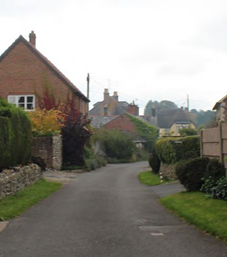
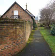
7.1.5 Whilst there are limited things that a Neighbourhood Plan can do to address traffic and road safety problems, it can help highlight local highway issues that should be considered in transport assessments, look at projects to help reduce the known issues (initial proposals are set out below in Table 8), and promote the use of safe routes through and around the village for pedestrians, cyclists and horse riders, that join up to make a comprehensive network. We call this ‘interconnectivity’. There are examples around the village where pockets of development have not ‘joined up’ (a prime example being the lack of a direct publicly accessible pedestrian link between Greenacres and Thompson Close, which could easily have been provided and offered a more pedestrian-friendly route than walking along the main roads). It is important that developers and planners learn from these mistakes so that they are not repeated in the future. Potential onward connections should be clearly shown on the site layout plans, and the publicly accessible routes through any development (and ongoing maintenance arrangements) secured by condition or legal agreement.
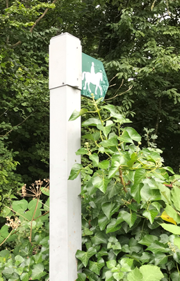
7.1.6 Routes for new footpaths / bridleways are also indicated on the Policies Map, but the actual alignment would be subject to negotiation with the appropriate landowners. Whilst these may be aspirational, they
would be of real benefit to local residents, improving access to the countryside through the ability to go on circular walks / rides of varying lengths, without needing to travel further afield. Such routes are likely to require funds, not only for suitable gates and signage, but also fencing / hedging and other measures to ensure that increased public access will not interfere with farming activities. Additional routes and improvement may be considered through a future review of this Plan.
7.1.7 And talking of the future – the need for electric vehicle charging points should also be considered in the design and location of parking spaces. A recent Government consultation22 has suggested that building regulations may be altered to ensure that all new buildings will be required to have electric vehicle charge points.
Map 8. Quiet Lanes and Connections and Large Vehicle Routes
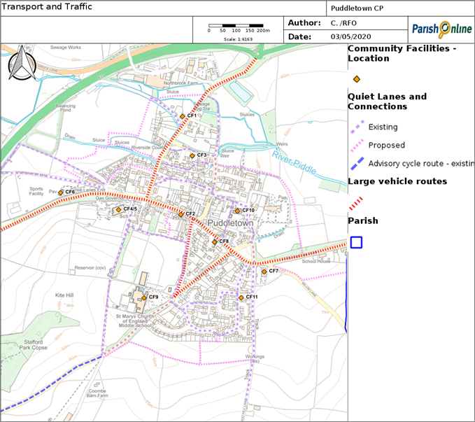
© Contains Ordnance Survey Data : Crown copyright and database right 2020,
© Crown copyright and database right. All rights reserved (100050773) 2020
Table 8. Traffic Management Proposals
| East entrance, Athelhampton Road | Some form of physical traffic calming infrastructure and clearer signage to encourage slower speeds at the entrance of the village. Measures should also be taken to reduce parking close to the junctions at Butt Close / The Green / The Surgery. |
| West entrance, road from the High Street to the Troytown Roundabout | The 30mph zone needs to be extended westwards and the gateway / entrance itself and 30mph zone needs clearer signage to encourage slower speeds, and a SID (speed indication device). A pedestrian pathway needs to be constructed from the Recreation Area car park to the First School either along the north side of the road, or along the bridleway to the north of the Recreation Area. In addition a ‘lollipop lady’ or a pedestrian crossing needs to be implemented where the road narrows in front of the First School. |
| North entrance, Blandford Road and the Moor | Clearer signage at the entrance of the village highlighting the start of the 30mph zone to encourage slower speeds, a second SID facing north at The Moor before the Backwater junction. Measures should also be taken to reduce parking immediately north of the Backwater junctions. A pedestrian crossing phase should be introduced at the traffic light controlled junction with High Street, to enable schoolchildren from the northern part of the village cross to the road safely to get to the First School. |
| New Footpaths / Bridleways | Southern route: connecting the Rodhill footpath / bridleway heading south alongside Butt Close and the Coombe, to provide alternative routes to the doctor’s surgery and Middle School, and complete the circular route for the southern half of the village. North-western link: connecting from Three Lanes (through the planned new estate), across the Moor and joining Blandford Road just south of the Blue Vinny, to provide alternative routes to the First School, Recreation Park and village pub, and complete the circular route for the north western portion of the village. North-eastern link: from the junction of Mill Street and the Backwater, and heading east, then south east to exit onto the Athelhampton Road, a more recreation-focussed route that would provide people with wonderful views of the meadowland and river landscapes in this area, and complete the circular walk for the north eastern portion of the village. Whilst outside of the Neighbourhood Plan area, a connection onwards along the Athelhampton Road, terminating at Athelhampton would provide access to a wide range of footpaths and bridleways originating at Athelhampton. Tolpuddle Martyr’s Trail: a route linking through from the Old Chapel in Tolpuddle to Shire Hall in Dorchester via Puddletown. Whilst this cannot be the exact route that the Martyrs would have taken (the old A35 trunk road in places remains too heavily trafficked to be an appropriate route), the concept is to use the public rights of way that, in the main, follow the ancient routes, and negotiate off-road links with landowners where no such routes exist. |
7.1.8 Whilst bus services have been greatly reduced across Dorset in recent years (including the service into the Poole / Bournemouth conurbation which was axed in 2014), Puddletown still benefits from a reasonably good 2-hourly service into Dorchester. The Dorchester service (via the X12 and also supplemented by the 187), runs during the week and on Saturdays (but there is no service on Sundays or into the evenings). This means people should be able to travel to work and shop in Dorchester, as well as access the hospital and other facilities found there. But for those who have no access to a car (which was about 1 in 10 households in 2011) it limits access to job opportunities outside the county town, and also limits access to leisure and recreation facilities that are typically used outside of normal working hours, and to some community facilities (such as the larger hospitals in Poole / Bournemouth).
Project P6. The Parish Council will work with the Highways Authority and local bus providers to identify initiatives that improve public transport connecting Puddletown to other transport networks and to nearby villages and large towns - this could include investigating the use of 'empty' school buses; the implementation of community bus schemes and/or demand responsive transport schemes.
7.1.9 Without reasonable alternatives, people are going to rely more heavily on private cars, so it comes as no great surprise that in 2011 about half of all households in the parish owned 2 or more cars (47% locally, compared to under 30% nationally and in towns such as Dorchester). With the decreasing bus service since 2011 the average number of cars in each household may well have risen further. Trips by private car is the least sustainable travel option, and more cars also means more localised parking problems, such as those noted above.
7.1.10 At the current time, the county parking standards (based on car ownership levels estimated from the 2001 Census) suggest that on smaller sites, the number of spaces should be based on the following guidelines:
plus at least 1 visitor space (which may be shared with up to 5 dwellings). In reality, car ownership levels are now higher than those predicted when the guidance was drawn up, and as such dwellings with 2 or more bedrooms should ideally aim to have at least 2 car parking spaces in addition to visitor spaces, particularly where there is limited scope for on-road parking.
7.1.11 The only other practical alternative to get into Dorchester (for those fit and able) is to cycle in, as the town centre is about 7 miles (40 minutes) by bicycle. There is an advisory cycle route up White Hill, turning south at Beacon Corner to join Ilsington Road and then east as far as Lower Bockhampton where the route goes south again to join the West Stafford Road into Dorchester (and there is a shared off-road route at this point).
Policy 15. Creating safer roads and pedestrian / cycle routes
Where development has the potential to connect via new or existing public rights of way to more than one road, publicly accessible pedestrian (and where feasible, cycle-friendly) routes should be provided through the development, so that more people are likely to walk rather than drive around the village. In particular, the provision of the pedestrian route connections identified in Table 8 (and as shown on the Policies Map) will be encouraged, and their future provision should not be compromised by development. The design of any such paths should:
Development that would adversely impact on the safe pedestrian use of the quiet lanes around the village (as shown on the Policies Map) and the safe use of the advisory cycle route into Dorchester will not be supported.
Where development would give rise to increased pedestrian movements within and around the village, proportionate developer contributions should be sought for improvements to the highway infrastructure and pedestrian routes identified in Table 8.
For major developments likely to generate a significant amount of construction traffic travelling through the village, a construction traffic management plan should be agreed with the Local Planning Authority in consultation with the Parish Council.
Policy 16. Parking Provision
Parking provision should meet the county car parking guidelines. The design and location should be convenient to the premises it is intended to serve (to avoid giving rise to poor parking on the highways and to promote the ease of use of electric vehicle charging points), avoid reliance on in-line provision (spaces end to end in a line or in front of a garage which creates a blocking effect that renders this layout less flexible and the parking spaces less effective), and be suitably landscaped with areas of planting to soften the impact of cars within the street scene. Proposals that include new or extended public parking facilities to serve the main community facilities are encouraged.
20 as recorded by the Police and reported on https://www.dorsetcouncil.gov.uk/roads-highways-maintenance/road-safety/road-traffic-collision-map.aspx
21 https://www.bournemouthecho.co.uk/news/17918451.biker-airlifted-crash-tractor-puddletown/
22 https://www.gov.uk/government/consultations/electric-vehicle-chargepoints-in-residential-and-non-residential-buildings - the consultation ended October 2019
< Previous | ^ Top | Next >