
7.1.1 Weymouth is the largest town in the plan area. It is also a nationally important tourist and recreation destination attracting half a million staying visitors a year, as well as having a significant commercial and employment base.
7.1.2 The borough has an exceptionally high quality landscape, seascape and built heritage, which makes it an extremely attractive place to live and work. However it also contains areas of multiple deprivation with some areas within the top 10% of deprived areas in the country. It also has an economy too reliant on low paid service jobs and faces difficult challenges due to potential sea level rise and extreme weather events.
7.1.3 The town centre is the retail, commercial, and tourist heart of Weymouth, including a ferry terminal and fishing wharfs. In order to continue the town centre’s important economic function for the area, issues of flooding and regeneration need to be addressed.
7.1.4 The area’s development has been strongly influenced by its peninsular location and topography. Consequently it has a close relationship with the sea, river valleys, escarpments and ridges. The areas surrounding the town centre are not continuously built up but are dissected by open spaces and landscape features, including large wetland nature reserves extending into the urban fabric. Much of the surrounding countryside is within the Dorset Area of Outstanding Natural Beauty and other parts of the borough include other national and international designations, which protect the environment but also restrict the amount of land available for future development. The high quality of life is a major attraction for people moving to the area, particularly to retire, and this ageing population places demands on health, housing and support services.
7.1.5 The administrative boundaries do not reflect the economic catchment and functionality of the borough. Much of the employment provision is in the adjoining settlement of Chickerell in West Dorset (the Granby and Lynch Lane Industrial Estates), and in Dorchester. As a result there is a high level of out-commuting.
7.2.1 In 2031 Weymouth will:
7.2.2 The tight administrative boundaries and environmental constraints mean that the supply of housing and employment land in Weymouth is limited. There are a number of development opportunities both within and on the edge of Weymouth that can help achieve this vision. These include:
7.2.3 There is an identified need for more land for cemetery use within the plan period, for which a long term strategy is required. The main cemetery for Weymouth is at Quibo Lane / Abbotsbury Road. The expansion of this site onto the adjoining Cross Road allotments provides the most feasible option for meeting this need, if replacement allotments can be provided. The Cross Road allotments are statutory allotments and any proposals affecting them will be carried out in accordance with the requirements of the relevant Allotments Acts. Land at Tumbledown Farm has been identified as a possible location for new allotments.
7.2.4 As part of the wider strategy for improving access to nature, land at Lorton Valley is identified as a nature park.
7.3.1 Weymouth Town Centre is an important place for a number of reasons. It is the main shopping area in the Borough, a significant tourist and recreation destination, and is a place where a range of businesses are based (including those related to the harbour, ferry and shipping activities), providing jobs and income to the area. It also has a wealth of listed buildings and an attractive waterfront environment. However without a clear strategy for development, it runs the risk of failing to meet its potential and falling into decline. There is also a significant and increasing risk of flooding in the area.
7.3.2 It is expected that the town centre regeneration will deliver at least 600 new homes and significant retail and business opportunities over the plan period. This will be guided by a Town Centre Master Plan that will be produced by the Borough Council in association with the local community and businesses.
7.3.3 The main issues currently facing the town centre are:
7.3.4 Weymouth Town Centre is a special place, for a number of reasons. The combination of the following specific qualities, that make it unique and special, should be retained and, where possible, enhanced:
7.3.5 In addressing future development within the town centre, the following priorities have also been established. Together, these form the main considerations against which all the proposals should be tested:
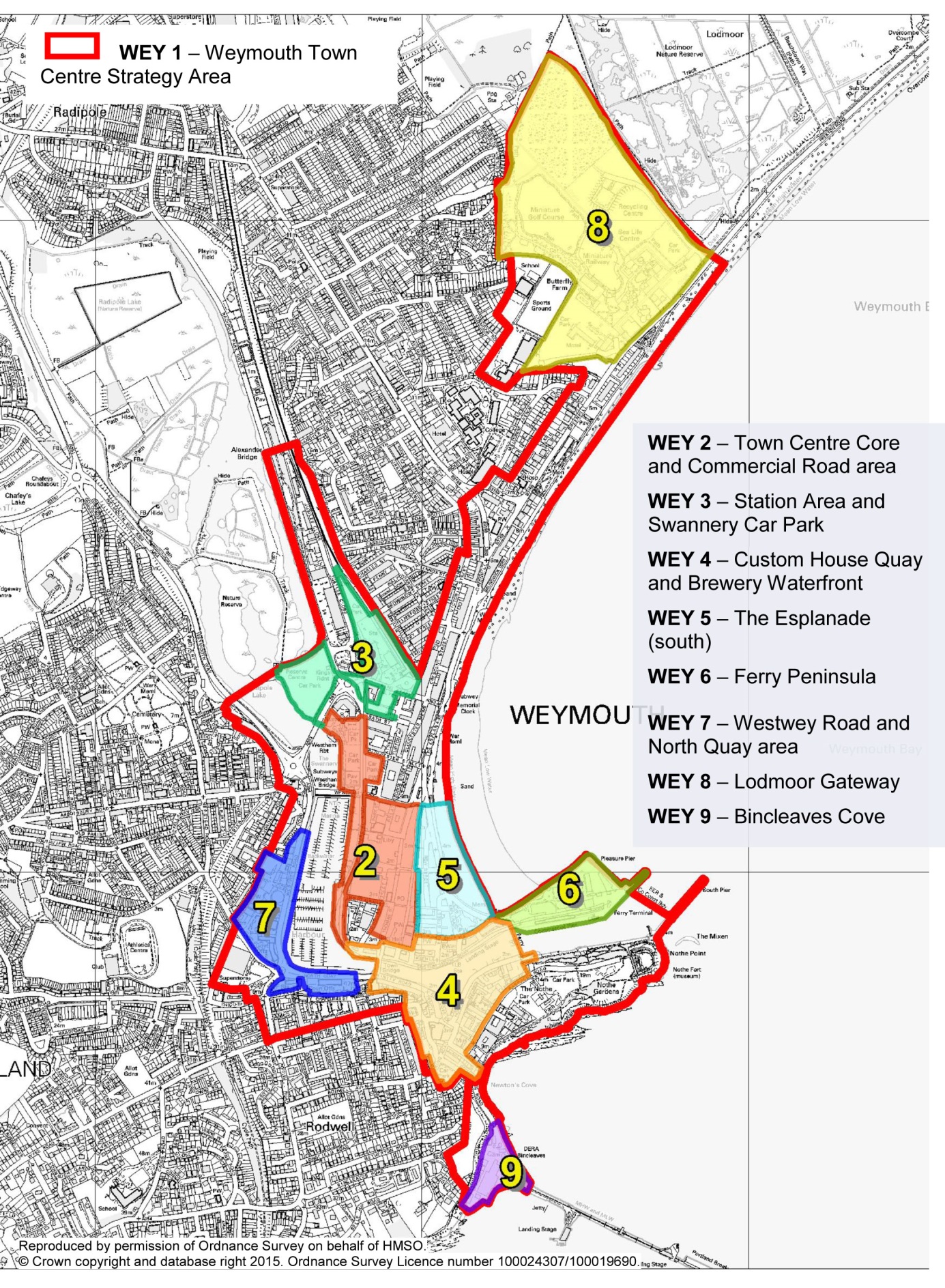
WEY 1. WEYMOUTH TOWN CENTRE STRATEGY
i) Development within the Weymouth Town Centre Strategy area (as shown in the policies map) must, as far as practicable, meet the following aims:
ii) The comprehensive development of key sites will be guided by a masterplan prepared by Weymouth & Portland Borough Council as a supplementary planning document. The masterplan will include more detailed guidance on design, movement (including parking provision), the general distribution of activities and uses in the wider area, as well as detailed guidance on the following key sites:
Figure 7.1: Key sites within the town centre strategy area - The following diagram shows the site boundaries for the following policies WEY 2 through to WEY 8. The location of WEY 9 is also illustrated.
7.3.6 The main focus for the town centre is to provide an attractive and vibrant place where people can access a range of local services and facilities including a diverse retail offer. The primary shopping area is a main feature and whilst Weymouth has a healthy town centre, it needs to evolve and improve, so that it can continue to compete effectively with other nearby shopping destinations such as Dorchester.
7.3.7 To ensure that the centre can continue to fulfil these roles and support the wider local economy, new development and the intensification of existing uses is needed. One of the strengths of the town centre is its attractive historic built heritage and wealth of listed buildings, but this also presents challenges for intensification and redevelopment to meet modern retail requirements. Much more could also be done to tie the built and waterside settings of Weymouth together, helping strengthen Weymouth’s reputation not only as a shopping destination, but also somewhere to combine shopping with more leisurely pursuits.
7.3.8 The main objective for this area is to promote a competitive and attractive retail sector of the town centre through sensitive, expansion, redevelopment and intensification of uses such as the more effective use of upper floors. A balance needs to be struck between ensuring there is no loss or substantial harm to heritage assets and the public benefit of maintaining a vibrant and vital centre which includes viable uses for historic buildings. The area west of the primary shopping streets towards the harbour frontages along Commercial Road is currently under-utilised in terms of both development of land and pedestrian footfall. It presents opportunities for development that could include provision of some larger comparison retail units and “family-friendly” food-led operations or other uses that are otherwise difficult to achieve in the historic buildings along the main high streets and in the area around the town bridge. Because of its westerly outlook the waterfront also receives late afternoon / evening sunshine, and therefore is better situated to have a focus for activities that can make the most of this benefit and fill the gap in activity between 5pm –9pm.
7.3.9 Any proposals should not significantly increase the number of late night entertainment uses in the prime retail areas. The introduction of upper-floor residential, together with complementary uses that would help out-of-hours activity, will be encouraged to ensure this area does not feel deserted in the evenings.
WEY 2. TOWN CENTRE CORE AND COMMERCIAL ROAD AREA
i) The primary shopping area will continue to be the main retail
core. A positive approach will be taken to finding solutions that
meet the requirements of modern retailing (to maintain a vibrant
and vital centre), whilst cherishing the area’s heritage
assets.
ii) Land to the west of the primary shopping area will be developed
with a mix of uses complementary to the primary shopping area.
Development should:
iii) Any proposals should not significantly increase the number of late night entertainment uses in the area.
7.3.10 The area around the station is in need of enhancement, and the presence of the bus depot / garage also detracts from the first impressions of the area. Redevelopment of the station area, which could be achieved through redevelopment with the depot and car-parking areas relocated (for example, onto land to the rear of the station), will provide an opportunity to improve the connectivity of different modes of transport, and introduce a more positive frontage and improve the legibility of the main pedestrian routes into the town centre.
7.3.11 The Swannery is a major public car parking area for the town centre, and it is important that any development in this area retains this function and focuses on improving the first impressions and creating good links into the town centre. Complementary development which improves the first impressions of the area and meets community needs will be permitted. In order to protect the vitality and viability of the town centre, proposals for new retail or other town centre uses will need to demonstrate the sequential approach in line with policy ECON4.
WEY 3. STATION AREA AND SWANNERY CAR PARK
i) The station area will be developed as a transport hub, including
a mix of retail, commercial businesses and residential to help
improve the first impressions of the area through the introduction
of positive and active frontage development and creation of a
high quality public realm.
ii) The Swannery Car Park will provide the main public car parking
area for the town centre, with the potential for complementary
development to help improve the first impressions of the area
without undermining the vitality of the town centre.
iii) Attractive pedestrian routes with active frontages should
link the Swannery Car Park and Station area with the town centre
core and commercial area, and seafront.
7.3.12 The areas around Custom House Quay and the Brewery contain a mix of restored heritage warehouses, fishermen’s cottages and town houses which lends itself very well to a cluster of independent restaurants and bars which is gaining a reputation for fine dining. Underpinning this dominant use is a healthy mix of local activity, including the existing sailing and dive clubs and the museum. Along with the Esplanade, this waterfront area is one of the most visually attractive parts of Weymouth.
7.3.13 The main focus for this area is to improve the pedestrian environment. The opportunity to “de-clutter” the quayside that pedestrianisation brings is significant and would allow for a more comprehensive approach to sitting-out. The potential to locate the flood defence barrier to the eastern end with a pedestrian crossing facility would also increase pedestrian footfall through this area.
7.3.14 The planned Brewers Quay re-development will include a museum, wet weather attraction, exhibition & craft space, retail and residential uses as part of the mixed-use scheme. With residential uses immediately adjacent to the southern part of this quarter, issues of noise and disturbance will continue to be a key consideration in any future changes.
WEY 4. CUSTOM HOUSE QUAY AND BREWERY WATERFRONT
i) The area around Custom House Quay, the Brewery, and its waterfront, will retain a mix of small scale restaurants, bars, cafes and retail uses. The old brewery will be retained as a major tourist facility where ancillary uses will be permitted that ensure the long-term maintenance of the tourist function and the future of this important listed building. Development should enhance the active waterfront area and the public realm including the removal of unnecessary street furniture, signage etc. and creation of areas for sitting-out.
7.3.15 The Esplanade is arguably the part of Weymouth that characterises its unique historic legacy as a seaside resort. Nearly all the buildings are listed, and retain much of their Georgian and Victorian architectural style and detailing. Together the terraces form a cohesive linear group, with relatively consistent building heights and strong rhythmic vertical definitions provided by the windows and chimneys. Although there are slight variations, no one structure dominates the terraces or overshadows the Nothe Fort to the south.
7.3.16 The combination of hotels, guest houses, cafes, bars, clubs, gift shops and amusement arcades fronting onto a wide stretch of sandy beach in the area south of Kings Statue is part of a classic modern seaside resort. However the clustering of late-night uses can result in crime and anti-social behaviour, and undue disturbance to hotel and guest house residents. As there are already sufficient late-night uses to create a cluster big enough to form a destination, additional music and dancing venues in this part of town should be avoided, and further residential or tourist accommodation uses considered carefully. Facilities that may help support outdoor events to bridge the gap of activity between shop closing times and the later opening times of some of the clubs (i.e. between 5 to 9pm) will be encouraged to help provide a “positive tone” at the start of the night, helping to moderate the behaviour of other user groups. Licensing should be used to bring about a deliberate and concerted wind-down during the early hours of the morning (i.e. between 3 and 6am) when no alcohol should be sold, to help overcome current tensions and allow for a period of clean-up of the public realm in preparedness for a return to daytime activity. A specific policy is contained to support this approach.
7.3.17 Further north, as distance from the town centre core increases, the uses become dominated by guesthouses and hotels. The main objective in this location is the retention and maintenance of the listed buildings, which are an inherent part of the character of the town centre.
7.3.18 The sandy beach is a major tourist attraction and provides a venue for many events and activities that add to the vibrancy of the town centre. Maintaining this important asset will be a priority whilst dealing with the consequences of sea level rise.
WEY 5. THE ESPLANADE (SOUTH)
i) The area of the Esplanade to the south the King’s Statue requires a careful approach to reduce crime and anti-social behaviour. This will include making sure:
7.3.19 The peninsula is a key site, set at the end of the Esplanade and opposite the historic Nothe Fort at the gateway to the harbour. It provides the first impression of Weymouth for those arriving from the sea, and is the home of the ferry terminal linking Weymouth to the Channel Islands. This ferry service provides many economic benefits to the town.
7.3.20 The area is run-down and requires significant investment to deliver a scheme that is appropriate for its setting and function.
7.3.21 A comprehensive approach to development will be needed in this area. Because of the abnormal costs associated with the redevelopment of this site, it is important that a flexible and realistic approach is taken on the mix of uses allowed. Although a leisure / tourism attraction would be supported, including a hotel, costs indicate that a scheme is unlikely to be economically deliverable without a significant element of housing. A range of solutions that would ensure the future of a thriving theatre for Weymouth and Portland will need to be considered.
7.3.22 Extreme care is needed to ensure that the scale and style of development is sympathetic to and does not dominate or detract from the adjoining historic areas of the Esplanade and the Nothe. Any building above the general height in this area is likely to be limited, although there may be scope to incorporate an elegant landmark, which could mark the terminus at the eastern end of the site.
WEY 6. FERRY PENINSULA
i) The ferry peninsula should be re-developed to include leisure
/ tourist-related uses, supported by complementary town centre
uses and which may include housing, and including provision for
the continued operation of the ferry service.
ii) A comprehensive scheme is required for the site which complements
the scale, mass and rhythm of the terraces along the Esplanade
so as to create a coherent seafront and does not detract from
the dominance of the Nothe Fort in views from the North. An elegant
landmark building may be permitted.
7.3.23 This area of land off Westwey Road and North Quay includes large civic offices, the former fire station around the bottom of Boot Hill, with undeveloped areas used for parking, the gasholder site and electricity substation, and areas of vacant land.
7.3.24 The redevelopment of this prominent area provides an opportunity to enhance the waterfront and make more efficient use of land. Particularly important are how the area relates to the historic buildings and remnants of the old High Street towards the town bridge and reinforce this local character, its relationship to the waterfront and to the key junction at the bottom of Boot Hill.
7.3.25 Landowners will need to work together to make sure the most effective approach is taken on complex issues, including contamination around the gasholder site and the potential provided through reclaiming land from the inner harbour.
WEY 7. WESTWEY ROAD AND NORTH QUAY AREA
i) The Westwey Road and North Quay area will be re-developed
for mixed uses which may include residential, hotel, commercial
and small scale retail development so as to create an active street
and water front.
ii) A comprehensive scheme is required for North Quay which will
complement the scale, rhythm and rich texture of the buildings
in Trinity Road to the East and High West Street to the South
so as to present an attractive frontage to the harbour and to
respect the historic buildings of the old High Street. Redevelopment
can proceed in phases provided it does not compromise the above
objectives.
7.3.26 Although some distance from the town centre commercial area, this site is linked to it and provides a key gateway to the built up seafront in the approach to the town centre from the east. It is important to the tourism economy as it forms part of the Lodmoor Country Park and contains the major tourist attraction of the Sea Life Centre, and associated facilities such as mini golf, a leisure ranch, and miniature railway. The area is also used for car parking, events and the household waste and recycling facilities. The site is further complicated due to its history as a landfill site, and the risk of flooding / coastal erosion. The area adjoins the Lorton Valley Nature Park which includes a large wetland area managed by the RSPB, part of which is a site of special scientific interest (SSSI). Both the Lodmoor and Lorton Parks are used extensively for informal recreation, walking and bird watching as well as visits to the more formal built tourist attractions based around the Sea Life Centre. Therefore any future development will need to take account of the sensitive nature conservation interests, open landscape setting, low key informal recreation as well the site’s important tourist and gateway function. The land contamination, associated drainage, and flooding issues will also need to be considered.
WEY 8. LODMOOR GATEWAY AND COUNTRY PARK AREA
i) Land at Lodmoor will be permitted for tourism, low key recreation and ancillary uses, appropriate to its gateway location and its proximity to sensitive sites. Any development will be expected to be of a high quality design and relate positively to the adjoining public areas. A comprehensive approach may be required to ensure that development complies with the aims of the Weymouth Town Centre Strategy.
7.3.27 The redevelopment of the QinetiQ site at Bincleaves Cove has been discussed for a number of years. In 2008 permission was given for a mixed use development of flats, a hotel and employment, which has now lapsed.
7.3.28 The coastal location and heritage of the site, with its links to the breakwaters and wartime defences, are unique and should be valued in the development of the site. Public access around the seaward edge of site is seen as an essential requirement. The impact of the design in terms of its views from coastal waters in the wider context of the bay (as part of the World Heritage Site) will also be a key consideration, as will how the history of the site and its links to adjoining areas (such as the breakwaters and defence buildings) can be reflected. These values also place limits on the possibilities for development, particularly the nature conservation value of the adjoining waters. And given its location below the cliff, it is not an easy site to develop, and issues such as sunlight / daylight will also be a key consideration to any occupied buildings and public or private amenity spaces. There is also the current requirement for the breakwater beyond the site to be accessible by HGVs and other traffic.
7.3.29 Coastal erosion and flooding are also issues for this site and so any proposal will need to be accompanied by appropriate geotechnical reports, vulnerability assessments and flood risk management reports.
7.3.30 As a former employment site it is considered important that any redevelopment of this site retains employment, and that it should be of a type appropriate to and taking advantage of the unique location benefits and constraints. Other complementary uses will also be allowed. An emphasis on good quality design is essential.
WEY 9. BINCLEAVES COVE
i) The redevelopment of this former employment site is supported.
This may either be through an alternative employment use appropriate
to a maritime location or through the comprehensive mixed use
re-development of the site to provide community benefits, including
sufficient employment uses to ensure no significant loss of potential
jobs.
ii) The development will be expected to be of a high quality design
appropriate to its waterside location and the unique history of
the site.
iii) Development will not be permitted if it would compromise
the nature conservation interest of the surrounding marine area,
have an adverse impact on the management and enjoyment of the
World Heritage Site, or be at risk from coastal change.
7.4.1 Land south of Chickerell Road (known as Markham and Little Francis) is within the existing built up area close to community facilities, shops, schools, employment areas and the transport network. It should be able to deliver in the region of 320 homes on the lower ground to the north of Cockles Lane, whilst providing public access and enjoyment of the open green spaces on the rising land and ridge to the south. This green space is important for its wildlife and landscape value and is expected to provide long-term public open space to serve the new development and benefit the wider community and allow for potential expansion of St Augustine’s School. Provision should be made for the long term management of the open space ideally by the transfer of the land to a public body, private trust or other appropriate organisation to manage as a semi natural green space / nature reserve. The existing hedgerows and track along Cockles Lane are important local features which should be maintained and incorporated into the layout of the site. Any loss of hedgerow will require mitigation such as the planting of new hedges. There is an ordinary water course within the site, and areas that are subject to surface water flooding, which should be carefully considered in the layout and design.
7.4.2 The site should accommodate a mix of housing types, particularly family housing, and could include some limited, small-scale employment uses appropriate to a residential area. The main vehicular access will be to the north off Chickerell Road, and footpath and cycle links must be provided to the surrounding area and as part of the strategic network.
7.4.3 The development generates a need for additional primary school accommodation, and an appropriate contribution towards improved provision will need to be secured. There may also be a requirement for land adjacent to St Augustine’s School to allow for future expansion.
7.4.4 On and off-site provision and contributions to community infrastructure will be sought in line with policy COM 1 and secured through a section 106 legal agreement.
7.4.5 A master plan for the whole area will be agreed by the Borough Council to guide the phasing and design of this site.
WEY 10. LAND AT MARKHAM AND LITTLE FRANCIS
i) Land at Markham and Little Francis as shown on the policies
map is allocated for residential development and public open space,
and may include an element of employment use appropriate to a
residential neighbourhood.
ii) Rising land to the south of Cockles Lane and the ridge further
south will remain undeveloped and be managed as public open space
for the long-term benefit of the local community and to protect
and enhance its nature conservation interest to become a designated
local greenspace.
iii) In order to address sustainable development issues, the site
should be developed in accordance with a masterplan prepared by
the developer / landowner in conjunction with the local community
and agreed by Weymouth & Portland Borough Council. The masterplan
will need to be subject to a sustainability assessment, such as
a BREEAM Communities Assessment, carried out by a suitably qualified
assessor. The masterplan should ensure that:
7.5.1 Land at Destiny Fields off Louviers Road has been granted planning permission for 176 new homes and is now under construction. An application for outline permission for approximately 100 new homes on land to the south of Louviers Road has also been approved.
7.5.2 Both sites abut a large tract of open and undeveloped land consisting of Wyke Oliver Hill, Lodmoor Marsh and Lorton Valley, parts of which are designated for their wildlife value, and are also valued for providing informal recreation opportunities. Much of this area is now included within the Lorton Valley Nature Park. Development off Louviers Road provides an opportunity to create a more positive relationship with the existing development and the adjoining open space. Any development needs to be contained and tapered into the hillside underneath the ridge crest so as not to have a detrimental impact on the landscape character of the wider area, and building heights will need to be limited relative to the ridge crest.
WEY 11. LAND OFF LOUVIERS ROAD
i) Land off Louviers Road as shown on the policies map is allocated
for residential development.
ii) Strategic landscaping will be required to soften the edges
onto the undeveloped countryside. The scale and design of development
should ensure that it is not overly prominent when viewed from
the south.
iii) Pedestrian links and wildlife corridors should be provided
through the developments connecting to Lorton Valley Nature Park
and adjoining areas of open countryside.
iv) Development should provide positive frontages onto the adjoining
road network.
7.6.1 Land west of the A354 Dorchester Road and to the south of Nottington Lane in the Wey Valley has the potential to deliver in the region of 320 new homes over the plan period.
7.6.2 The site is within a sustainable location close to facilities including schools, sport and recreation facilities, shops and employment sites.
7.6.3 It is important that development in this location does not result in the physical or visual convergence of the urban area of Weymouth and more rural Nottington, and a substantial green buffer will be retained alongside substantial tree / woodland planting. There are also longer views of the northern part of the site from the Ridgeway and planting belts running east to west across this part of the site will be needed to mitigate this impact. The retention of hedgerows will also be important to provide wildlife corridors through the site.
7.6.4 Parts of the site are susceptible to surface water flooding and so sustainable drainage systems should be implemented to ensure adequate surface water drainage provision and that flood risk is not exacerbated elsewhere.
7.6.5 The layout should include at least one access point from the A354 in addition to an access from Nottington Lane to ensure it links well into the urban area. Properties along the A354 back directly onto and will overlook the site. The design and layout will need to ensure that the amenity of these properties is not significantly adversely affected.
7.6.6 Any employment uses should generally be grouped together rather than dispersed throughout the scheme. Small workshops or live-work units using existing buildings or reproducing the layout of former employment uses such as old farm complexes can provide variety and links with historic uses of the site.
WEY 12. LAND AT WEY VALLEY
i) Land at Wey Valley as shown on the policies map is allocated
for residential development and should include an element of employment
use appropriate to a residential neighbourhood.
ii) The site should be developed in accordance with a masterplan
prepared by the developer / landowner in conjunction with the
local community and agreed by Weymouth & Portland Borough
Council. In order to address sustainable development issues, the
masterplan will need to be subject to a sustainability assessment,
such as a BREEAM Communities Assessment, carried out by a suitably
qualified assessor. The masterplan should ensure that:
7.7.1 Land at the Old Rectory, Lorton Lane has potential for new housing.
7.7.2 It is within Broadwey Conservation Area and surrounds the listed Old Rectory building. The site could deliver in the region of 39 new homes, but will need to be carefully designed. The development of this site will be linked to environmental improvements on the land to the north of the Old Rectory and the removal of the existing established uses (such as the builders' yard, car repairs and waste transfer station). The main vehicular access would be via the existing access off Dorchester Road and the possibility of footpath /cycle / bridleway links with the wider area should be explored.
WEY 13. LAND AT THE OLD RECTORY, LORTON LANE
i) Land at The Old Rectory, Lorton Lane, as shown on the policies map, is allocated for residential development. Any development must enhance the Old Rectory and Broadwey Conservation Area.
7.8.1 Consent was given in 2007 for a 14ha mixed-use employment site. This provided a site for the new headquarters building of New Look, a hotel and retail supermarket. There is a large area of the site still to be developed that will provide significant additional business opportunities, including small scale enterprise units. The New Look headquarters and the remaining area of the site is designated as a key employment site.
7.9.1 Tourism is an important part of the local economy in Weymouth and the retention of attractions and facilities or sites available for this use will maintain the attractiveness of the area to tourists. Sites within the town centre such as Lodmoor and Brewers Quay will be protected through policies in the Town Centre Strategy, however development at Bowleaze Cove would not be within this area.
7.9.2 Any proposals will need to be appropriate to the sensitive coastal landscape and nature conservation and geological importance. The area is also subject to erosion and fluvial and tidal flooding via the River Jordan. It is within an area identified in the Shoreline Management Plan for future managed realignment and so is only appropriate for time limited (temporary) development that would not be at risk from, or exacerbate, coastal erosion or flooding.
WEY 14. BOWLEAZE COVE
i) Development at Bowleaze Cove as shown on the policies map will be restricted to time-limited tourist and leisure related development.
7.10.1 Tumbledown Farm comprises open agricultural grassland, water meadows and areas of woodland outside the development boundary, but within the Radipole Conservation Area. Parts of the holding are designated as a Site of Special Scientific Interest.
7.10.2 There is the potential to use part of the site to provide space for a significant number of allotments, which would reduce current waiting lists. Land is also sought in the borough to provide for the disposal of human cremated remains in a natural setting away from the current cemetery / crematorium sites, and for the burial of pets (or their cremated remains). There is also an opportunity to relocate the RSPB operational base from its current residential area closer to the land they manage, and provide a better location for the council’s parks service and its nursery which is currently taking up part of the Crookhill depot and employment land at Lynch Lane. Limited development based around the existing farm buildings could provide ancillary accommodation for the various proposed uses however this would be subject to detailed design and ensuring that the landscape character and important open gap function of the land is maintained.
WEY 15. LAND AT TUMBLEDOWN FARM
i) Land at Tumbledown Farm as shown on the policies map is allocated for cemetery uses, allotments/ community food provision and ancillary office / workshop / storage space. Development of these uses will only be permitted if it does not undermine the important open gap function, and the nature conservation interests and landscape character of the site are protected and enhanced.
7.11.1 The proposal for the Lorton Valley Nature Park is very much a partnership project involving Weymouth & Portland Borough Council, Dorset Wildlife Trust, RSPB, Dorset Countryside Service and Natural England.
7.11.2 The Nature Park comprises a total of 194 hectares (479 acres), that extend from Southdown Ridge in the north, to Preston Beach Road in the south and runs between the new relief road and Horse Lynch Plantation. It links up the Lodmoor Nature Reserve, Two Mile Copse and Lorton Meadows (all Sites of Special Scientific Interest) and two areas of land (to the east of the park & ride site at Mount Pleasant and land to the east of the Lorton Meadows) provided as a result of the relief road construction. A further area of open undeveloped land located to the north of the civic amenity and composting sites and immediately adjacent to the RSPB reserve is linked. Additional agricultural land to include the Southdown Ridge should also to be included to provide a more comprehensive network. There is the aspiration for the nature park to be extended into areas to the north and north east of the current boundary, including Wyke Oliver Hill. This additional land will help improve public access and amenities, help secure wildlife corridors, provide opportunities for biodiversity enhancement and protect and enhance local landscapes. Green infrastructure associated with the Littlemoor Urban Extension could potentially become a northern extension of Lorton Valley Nature Park.
7.11.3 This land will be incorporated into the Green Infrastructure Network and protected under policy ENV 3.
WEY 16. LORTON VALLEY NATURE PARK
i) Land between Preston Beach Road and Southdown Ridge, as shown on the policies map, is allocated as part of the Lorton Valley Nature Park to promote sustainable tourism, management of conservation and heritage interest, enhancement of public access and open spaces and opportunities for volunteer and community involvement.
< Previous | ^ Top | Next >