
1.1.1 The planning system governs the use and development of land. It controls which new buildings will be built and where they should go. Nationally there is a presumption in favour of sustainable development and local councils are expected to plan positively for the needs of their area.
1.1.2 The local plan is the main basis for making decisions on planning applications. Planning decisions must be made in accordance with the local plan, unless material considerations indicate otherwise. And it gives local communities, developers and investors greater certainty about the types of applications that are likely to be approved. The local plan sits alongside the National Planning Policy Framework, which must also be taken into account in making decisions on planning applications and in the preparation of local and neighbourhood development plans.
1.1.3 Neighbourhood development plans, when adopted, will form part of the development plan. These are prepared by the local community (such as the parish or town council, or elsewhere a neighbourhood forum). These can be as simple, or as detailed, as local people want, provided that they are in line with national planning policy, and the strategic policies of the local plan. Where they are in conflict the policies contained in the neighbourhood development plan will effectively replace the non-strategic policies in the local plan for that neighbourhood. Where this plan or any development plan documents are adopted after a neighbourhood plan has been adopted, the council will issue a statement of conformity to clarify whether any policies in the neighbourhood plan are superseded.
1.1.4 Other development plan documents and supplementary planning documents may be produced when necessary to cover specific topics, sites or to provide more detailed guidance. These too will be taken into account in any planning decisions. All relevant planning policy documents can be seen at the council offices and on www.dorsetforyou.com.
1.1.5 The plan period extends to 2031. However it is likely to be reviewed well before the end of this plan period, in whole or in part, to ensure that there are sufficient developable sites available for future needs. It may also need to be updated to respond to unforeseen changes.
1.1.6 This document has been produced by West Dorset District Council and Weymouth and Portland Borough Council as the key development plan document for the area. It has been informed by both Councils’ Corporate Plans and the Community Plans developed by the West Dorset Partnership and the Weymouth and Portland Partnership.
1.1.7 Whilst the plan has been jointly prepared, decisions on land within the boundaries of each council area have been made by the council for that specific area. Planning applications will continue to be determined by each council for its own area.
1.1.8 The next sections of this chapter contain an overall description of the plan area and the issues it faces (the plan’s context), the overarching VISION and STRATEGIC OBJECTIVES for the plan, and the STRATEGIC APPROACH which provides the strategic policy direction for the plan and any related development plan documents.
1.1.9 This document is then split into chapters covering:
1.1.10 For each of these themes there is the relevant excerpt from the strategic approach which sets the over-arching strategy for that topic, and more detailed policies that will be applied to specific issues or types of development.
1.1.11 Following this, there are visions and site-specific policies for each of the main towns and areas of growth, being WEYMOUTH, PORTLAND, LITTLEMOOR, CHICKERELL, DORCHESTER, CROSSWAYS, BRIDPORT, BEAMINSTER, LYME REGIS and SHERBORNE. The remaining settlements do not have specific policies but may still be covered by neighbourhood development plans prepared by that local community, which will become part of the development plan. A map of agreed neighbourhood areas will be published by each Council.
1.1.12 A glossary has been included at the back of this local plan. This explains what is meant by some of the terms used. Some of the key definitions are also included in boxes within the plan itself.
1.1.13 Planning policies are written in bold and are prefaced by the chapter abbreviation and policy number (eg: SUS 3). In deciding whether a planning application is in conformity with the local plan, it is the wording of these policies that are the main focus. The accompanying text generally provides some explanation as to why the policy has been included. It may also include specifics on the type of information that may be required to help decide whether a policy test is met.
1.1.14 The plan should be read as a whole. Therefore policies on specific uses will not duplicate general issues such as the protection of heritage assets, nature conservation or the impact on the transport network, which are dealt with under those topic areas.
| The use of the words ‘will’ and ‘should’
Policies in the plan are written to cater for a wide range of
planning applications, from small-scale domestic extensions up
to large, mixed use development sites. Because of this,
some flexibility needs to be built into the policy tests on occasion. |
1.1.15 The plan brings together a large amount of government policy, research and evidence that have helped inform the planning policies that have been agreed. Further information can be found in the Background Papers on the website (www.dorsetforyou.com). And as part of the legislative requirements, a Sustainability Appraisal has also been produced which includes an assessment on equalities and health impacts.
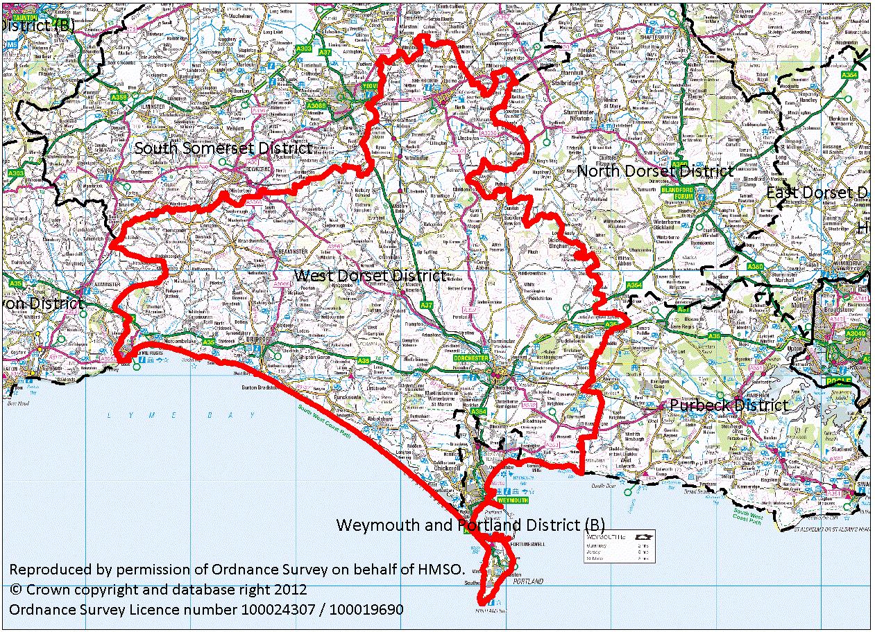
1.2.1 The plan area covers the entire administrative area of West Dorset and Weymouth and Portland in the county of Dorset. There are strong links between the two council areas, and with neighbouring areas of Yeovil to the north, and Bournemouth and Poole to the east.
1.2.2 West Dorset is renowned for its outstanding environment, including a varied and beautiful landscape underpinned by great geodiversity which is expressed in the internationally recognised coastline, the Jurassic Coast World Heritage site attractive villages and market towns. It has a range of cultural and historic associations, including those with Thomas Hardy’s novels, the Tolpuddle Martyrs and early discovery of fossils at Lyme Regis. Despite the high quality of life enjoyed by many in West Dorset there is a lack of affordable housing and some issues of rural isolation.
Figure 1.1: West Dorset, Weymouth and Portland plan area
1.2.3 The Borough of Weymouth & Portland has an exceptionally high quality landscape, seascape and built heritage, and is a major tourist resort. However, it contains areas of multiple deprivation, with parts of Weymouth Town Centre, Littlemoor, Westham and Fortuneswell within the top 20% of deprived areas in England and Wales.
1.2.4 The main towns in the area are1:
| Weymouth 52,320 population |
Weymouth is the largest urban area in Dorset, with its town centre and Esplanade as the retail, commercial, leisure, cultural and tourist heart of the Borough. The town is not a continuous built‐up area but is dissected by open spaces and landscape features, including large wetland reserves. |
| Dorchester 19,060 population |
Dorchester is the largest town in West Dorset and has been the county town of Dorset since 1305. A market is held on Wednesdays. Major employers include Dorset County Council, West Dorset District Council and Dorset County Hospital. |
| Bridport area2 13,570 population |
Bridport is a market town located near the coast at the western end of Chesil Beach, at the confluence of the River Brit and its Asker and Symene tributaries. It originally thrived as a fishing port and rope-making centre. |
| Portland 12,840 population |
Portland is physically and visually separated from Weymouth, linked by a single carriageway road on the causeway adjacent to Chesil Beach and The Fleet. Although an entity in its own right, Portland is made up of a group of villages, each with very distinctive features. The Port is an important regional facility and has potential to play a more significant role in the UK. Considerable regeneration has taken place here over the last 15 years. |
| Sherborne 9,520 population |
Sherborne is a market town on the River Yeo and A30 road, on the edge of the Blackmore Vale east of Yeovil. Sherborne is famous for its abbey, castles, manor house and private schools. Much of the town, including many medieval and Georgian buildings and the Abbey, is built from distinctive ochre ham stone. |
| Chickerell 5,520 population |
Chickerell is a small town north-west of Weymouth. Historically, fishing and brick making were the main industries in the area. The main employment area is now the Granby Industrial Estate. |
| Lyme Regis 3,670 population |
Lyme Regis is a coastal town in Lyme Bay, on the English Channel coast at the Dorset-Devon boundary. The town is noted for the fossils found in the cliffs and beaches, which are part of the Heritage Coast—known as the Jurassic Coast—a World Heritage Site. |
| Beaminster 3,140 population |
Beaminster is a small town standing at the head of the valley of the River Brit. It hosts the Beaminster Festival, an annual nine-day music and art festival. The historic routes and plot patterns radiating out from the small market square, together with the local building materials, exert a strong influence on the character of the town. |
1.2.5 The population of the area has increased gradually over time and has been projected to continue to grow in the future. The level of growth has varied between towns and over the period, with some areas having experienced significantly more change than others.
Table 1.1: Percentage (%) population change from 1991 – 2011
| 1991 | 2001 | 2011 | 91-01 | 01-11 | 91-01 | 01-11 | |
| Beaminster | 2,770 | 2920 | 3140 | 150 | 220 | 5% | 8% |
| Bridport | 11,690 | 12,730 | 13,570 | 1040 | 840 | 9% | 7% |
| Chickerell | 4,160 | 5310 | 5520 | 1150 | 210 | 28% | 4% |
| Dorchester | 15,100 | 16,180 | 19060 | 1080 | 2880 | 7% | 18% |
| Lyme Regis | 3,760 | 3,530 | 3,670 | -230 | 140 | -6% | 4% |
| Portland | 13,190 | 12800 | 12840 | -390 | 40 | -3% | 0% |
| Sherborne | 8,740 | 9310 | 9520 | 570 | 210 | 7% | 2% |
| Weymouth | 48,010 | 50,920 | 52230 | 2910 | 1310 | 6% | 3% |
| West Dorset | 85500 | 92400 | 99300 | 6900 | 6900 | 8% | 7% |
| Weymouth and Portland | 61200 | 63700 | 65200 | 2500 | 1500 | 4% | 2% |
| Plan area | 146,700 | 156,100 | 164,500 | 9400 | 8400 | 6% | 5% |
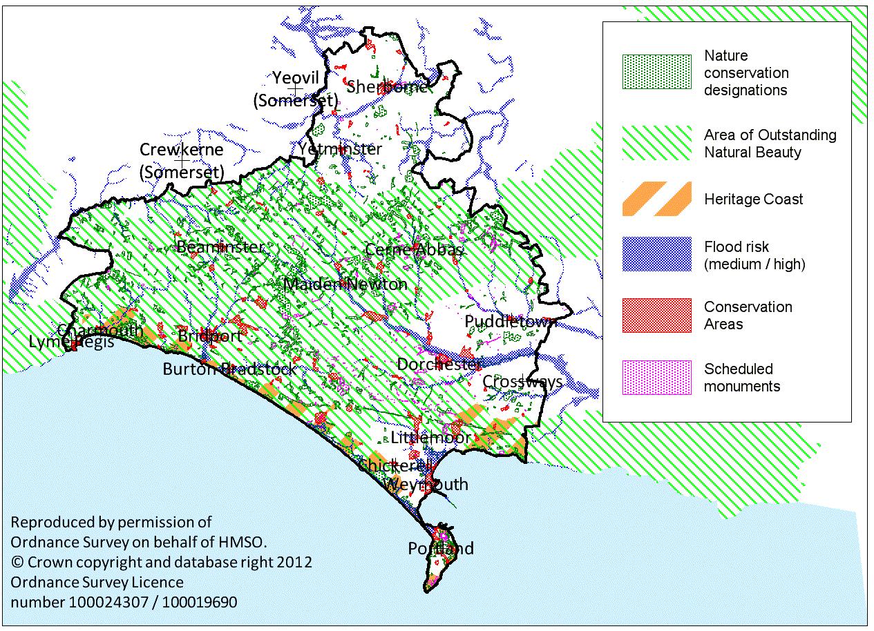
1.2.6 The area contains a rich and wide variety of landscape, natural and built heritage features. The combined area of Weymouth & Portland Borough and West Dorset District is approximately 112,000ha. Just over two-thirds of the plan area (69%) is designated as an Area of Outstanding Natural Beauty (AONB), and a major part of the coastline is designated as a Heritage Coast and World Heritage Site. Over 3,200ha (approximately 3%) of land is of international importance for its nature conservation value, including coastal areas around the Fleet, and the Dorset heathlands to the east. A further 1,170ha (1%) are of national nature conservation importance. There is also a rich built heritage with many special places and buildings from all periods, with over 90 Conservation Areas, and over 7,000 Listed Buildings of architectural or historic interest.
1.2.7 Some of the key issues that face our environment include the pressures of development on greenfield sites, visitor and traffic pressures, and changes in farming practices. However there are also many positive opportunities that development can bring, including improved land management and infrastructure as well as the use of good quality design and materials to enhance the appearance of the area.
1.2.8 Climate change is expected to increase instances of extreme weather including flooding and coastal erosion. There is a need to ensure that both existing and new communities are able to adapt in the long term as protection may not always be possible.
Figure 1.2: Environmental designations
1.2.9 The 2008 Place Survey showed that there was a high level of satisfaction from people living in the area. 85% of people living in Weymouth and Portland, and 91% of people living in West Dorset, said they were satisfied with their local area as a place to live.
1.2.10 There is a high level of affordable housing need, with over 3,000 people on the housing register in West Dorset and 4,600 in Weymouth and Portland. The average house price outstrips local wages by a factor of 11 in Weymouth and Portland, and by a factor of 12 in West Dorset. More than 1 in every 20 homes in West Dorset is either a second or holiday home, and this proportion is especially acute in some coastal resorts. Increases in fuel prices will impact on local people, particularly those in older properties that have a poor energy performance rating.
1.2.11 The population is becoming increasingly elderly as people live longer and also because many people who come to live in this area are close to retirement age. This imbalance is exacerbated as young people also move out of the area because of limited opportunities to get relevant employment and relatively high local house prices.
Figure 1.3: Access issues
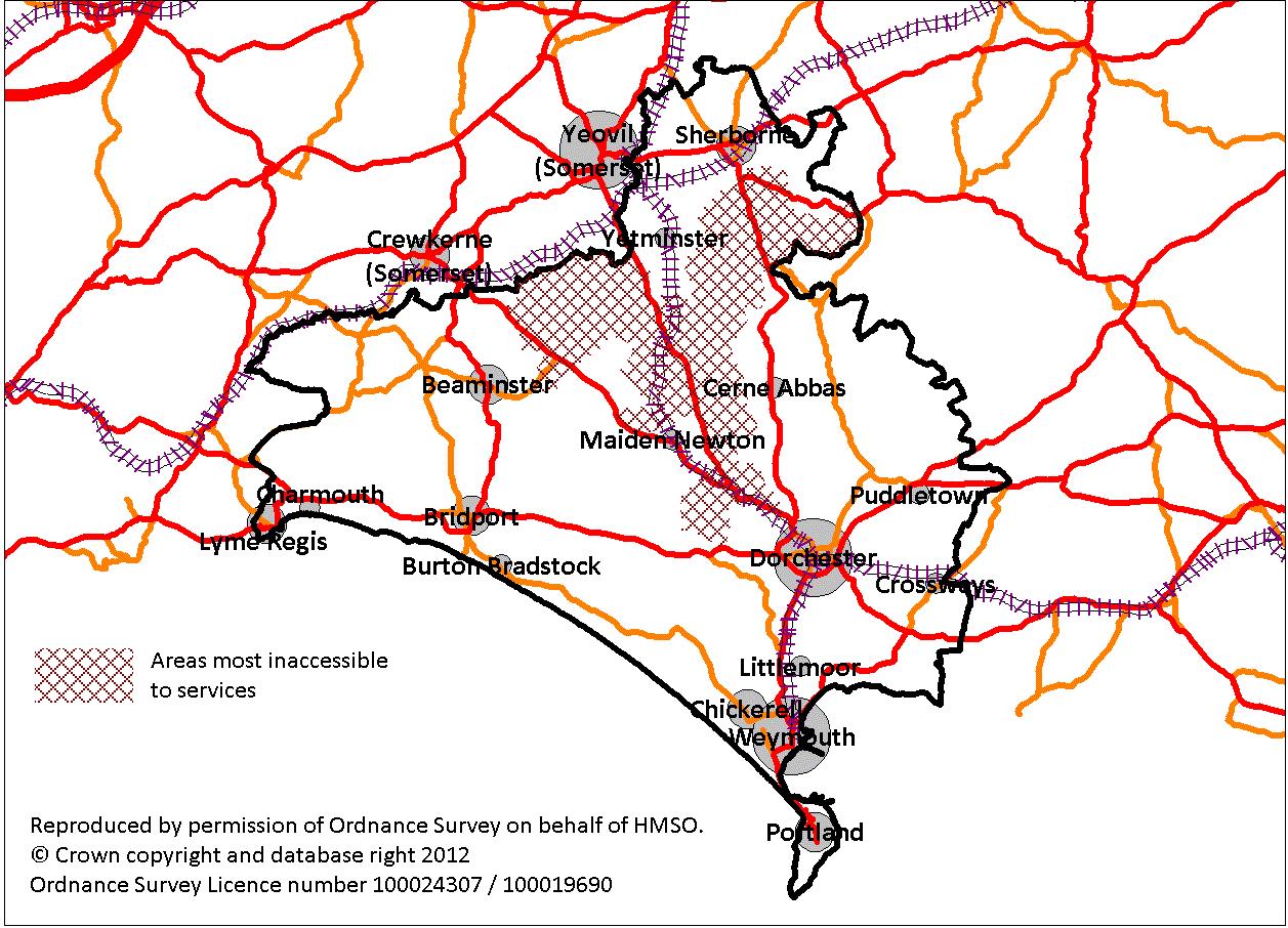
1.2.12 There are no motorways within the area but there are rail links to London and Bristol. The ferry terminal in Weymouth Harbour serves the Channel Islands. Transportation can be a problem in the more rural areas where public transport provision is limited: some parts (Halstock, the Frome Valley, and the Cam Vale) are in the top 1% of areas in the country that are most inaccessible to services. This also has an impact on costs (and the carbon footprint) of local service provision, such as those borne by the county council and NHS in transporting people to schools and medical facilities. Movement patterns indicate that distances travelled to work often exceed 10km, particularly from outlying rural areas. In Weymouth and Portland, many outbound commuters work in Dorchester. Significant seasonal variations in travel demand and movement often lead to further transport problems and congestion, particularly in urban areas. However over £100 million investment in the strategic road network has been made to relieve traffic congestion in Weymouth and improve the travel time within the Weymouth to Portland transport corridor.
1.2.13 West Dorset has a relatively low rate of crime; however, Weymouth and Portland has some of the highest crime rates in Dorset and includes a number of areas that have a higher than average crime rate compared with the rest of England and Wales. This is partly due to the greater density of population in an urban area, relative to the more dispersed rural populations, and is exacerbated by the high number of visitors during the holiday season. The 2008 Place Survey indicated that about one in four residents of Weymouth and Portland felt unsafe after dark, compared to one in 10 in West Dorset.
1.2.14 Arts and other cultural facilities can help stimulate new skills, encourage people to interact and reinforce their sense of belonging. The rural nature of West Dorset means there are limited entertainment, art and culture opportunities when compared with other districts. The main arts provision in West Dorset is in Bridport, although further provision is planned for Dorchester and Sherborne. In contrast, Weymouth and Portland has a greater concentration of cultural and leisure attractions and venues. Some of these venues are thriving through wider influences such as the Olympics and the designation of the East Devon and South Dorset coastline as Britain’s first Natural World Heritage site, although others require significant investment.
1.2.15 Health inequalities are increasing. Poor health is more prevalent among people on lower incomes, and where there is limited access to facilities that benefit health. In West Dorset this is most apparent in the more rural and isolated areas. Weymouth and Portland, as a predominantly urban area, has concentrations of health deprivation, including mental health, childhood obesity, and teenage pregnancy, in certain areas, with the most serious being found in Fortuneswell South and Littlemoor North.
1.2.16 Wage levels are lower than the national average and there is a reported shortage of labour with relevant skills or training. This may increase over the plan period as a large proportion of existing trades people are due to retire.
1.2.17 Over 12,000 premises (about 38% of all premises) in West Dorset do not have access to broadband speeds of more than 2 megabits per second, and about 1,500 premises in Weymouth and Portland. Significant investment has begun to roll out superfast broadband throughout Dorset starting in 2012. Coverage of telecommunications masts has improved significantly but is still limited in places.
1.2.18 Whilst some towns, such as Bridport, have relatively balanced levels of jobs and housing, other towns, most notably Weymouth and Dorchester, have a significant imbalance. Weymouth has a significant amount of outward commuting to Dorchester for jobs, and Dorchester relies on a much wider area for its workforce and economic success. Many Portlanders have had to look for job opportunities on the mainland and some of the employment opportunities created on the island do not match the skills of the local workforce. In Sherborne there is an inward flow of lesser-skilled workers who cannot afford the local house prices, and an outward flow of the higher-skilled workforce to jobs elsewhere outside the town.
1.2.19 Councils and other public bodies are expected to work together across administrative boundaries to plan for the housing, transport and infrastructure that local people need. This joint plan shows how the cross-boundary issues between Weymouth and the adjoining areas of West Dorset are being addressed. West Dorset District Council is also liaising on cross-boundary working in relation to the following locations to bring forward the right development for that area:
A Vision for West Dorset |
A Vision for Weymouth & Portland |
The spectacular landscapes of West
Dorset, from the panoramic chalk ridges to the wooded valleys
and undeveloped coastline, the picturesque settlements and variety
of natural habitats, are something that set it apart from the
rest of the country. We are proud of this, and want to be
able to say the same in 20 years' time. |
We want the next 20 years to be an
exciting time for the Borough, with significant investment and
regeneration of key sites and infrastructure, making this a place
where people of all ages will be engaged with their local community,
feel a real sense of belonging and civic pride. |
1.3.1 Realising the vision will rely upon many different stakeholders and service providers. Strategic objectives have been identified, which provide a concise expression of the priorities of this Local Plan.
| STRATEGIC OBJECTIVES |
Support the local economy to provide opportunities for high quality, better paid jobs |
Meet local housing needs for all as far as is possible |
Regenerate key areas including Weymouth and Dorchester town centres, to improve the area’s retail, arts, cultural and leisure offer; and increase employment opportunities |
Support sustainable, safe and healthy communities with accessibility to a range of services and facilities |
Protect and enhance the outstanding natural and built environment, including its landscape, biodiversity and geodiversity, and the local distinctiveness of places within the area – this will be the over-riding objective in those areas of the plan which are particularly sensitive to change |
Reduce vulnerability to the impacts of climate change, both by minimising the potential impacts and by adapting to those that are inevitable– this will be the over-riding objective in those areas of the plan which are at highest risk |
Provide greater opportunities to reduce car use; improve safety; ensure convenient and appropriate public transport services; and seek greater network efficiency for pedestrians, cyclists and equestrians |
Achieve high quality and sustainability in design, reflecting local character and distinctiveness of the area |
| STRATEGIC APPROACH |
| ENVIRONMENT AND CLIMATE CHANGE Development
should protect and enhance the natural environment - its landscape,
seascapes and geological conservation interests, its wildlife
and habitats and important local green spaces - by directing development
away from sensitive areas that cannot accommodate change. Where
development is needed and harm cannot be avoided, appropriate
mitigation to off-set any adverse impact to the landscape, wildlife
and green infrastructure network will be required. |
| ACHIEVING A SUSTAINABLE PATTERN OF DEVELOPMENT In the period 2011-2031 development should help deliver a steady supply of employment and housing land to meet projected needs (about 60ha of employment land and 15,500 new homes across the plan area). The distribution of development is influenced by:
The strategic allocations provide the main development opportunities
and are fundamental to delivering sufficient development. These
are located at Beaminster, Bridport, Chickerell, Crossways, Dorchester,
Lyme Regis, Portland, Sherborne and Weymouth (including an area
north of Littlemoor that lies partly within West Dorset), and
are indicated in Table 3.7. The main towns and smaller settlements
with defined development boundaries also provide a considerable
supply of smaller sites through redevelopment and infill opportunities
that will contribute towards meeting the requirements . |
| ECONOMY A continuing supply of land and
premises suitable for employment uses is needed, of a type and
scale appropriate to the characteristics of the local area, to
provide sufficient opportunities for employment needs to be met
locally, to reduce the need to travel and promote economic growth
and social inclusion. This will be delivered through the allocation
and provision of new sites (with the greater proportion of development
at the towns), the suitable protection of existing employment
sites (taking into account their significance), and flexible policies
to allow development to come forward on other suitable sites. |
| HOUSING A continuing supply of housing
land is needed to help meet the changing demographic and social
needs of the area, and to help reduce the need to travel and promote
economic growth and social inclusion. The type, size and mix of
housing will be expected to reflect local needs as far as possible
and result in balanced communities. |
| COMMUNITY NEEDS AND INFRASTRUCTURE Community
facilities that help promote social interaction as well as minimise
the need to travel by car should be provided within local communities.
Where possible and practicable (for example on larger developments),
new local community facilities will be provided as part of the
development, creating attractive and vibrant places to live. Existing
local facilities will be protected through a flexible approach
which recognises the changing needs in society. |
1.3.2 Communities preparing Neighbourhood Development Plans will need to show how their proposals are in general conformity with this strategic approach.
1.4.1 The National Planning Policy Framework recognises the international imperative to tackle climate change and finding ways to enhance and improve the places in which we live our lives. It makes reference to the three aspects of sustainable development; economic, social and environmental. And it states that the planning system should play an active role in guiding development to sustainable solutions.
1.4.2 The councils will take a positive approach when determining planning applications which reflect the presumption in favour of development contained in the National Planning Policy Framework. The councils will work proactively with applicants jointly to find solutions which mean that proposals can be approved wherever possible, and to secure development that improves the economic, social and environmental conditions in the area. The councils encourage pre application consultation and discussion with applicants and agents prior to planning applications being submitted, enabling applications to be determined in a more efficient and positive manner.
1.4.3 Planning applications which are consistent with the local plan policies (and where relevant, with policies in neighbourhood plans) will be approved without delay where practicable, unless material considerations indicate otherwise.
1.4.4 Pursuing sustainable development requires careful attention to viability and costs in decision-making. The plan as a whole has been subject to viability studies which have tested a range of development types throughout the plan area. With regard to individual developments, the councils will take a reasonable approach to requests to consider viability issues when assessing the level of on and off site contributions on development proposals and / or need for enabling development. Each request will be considered on its own individual merits, particularly taking into account the need to deliver the site, the detailed financial situation, the length of time over which the project is planned, local circumstances and the requirements of the development plan.
INT1. PRESUMPTION IN FAVOUR OF SUSTAINABLE DEVELOPMENT
i) There will be a presumption in favour of sustainable development that will improve the economic, social and environmental conditions in the area. Where there are no policies relevant to an application, or relevant policies are out of date at the time of making the decision, the following matters will be taken into account:
1.5.1 Although the plan is written to cover 20 years to 2031, it is likely that a review of the plan will be put in place by 2021. This is necessary not only to ensure provision of sufficient housing land to 2031, but also to ensure a continuity of policy beyond 2031 and to respond to unforeseen changes that are likely to occur during the plan’s lifetime.
1.5.2 Monitoring and, where relevant, targets, are included in relation to specific policies in the plan. The councils will regularly monitor the extent to which the policies are effective and what they are delivering in terms of new development, social and economic factors and environmental protection. The councils will continue to engage and work collaboratively with service providers to review infrastructure requirements and regularly update the Infrastructure Delivery Plan. The councils will also consider what implications changes to national policy may have on the effectiveness of the plan. The role of neighbourhood development plans will also be monitored as they have the ability to play a key role in the planning of new development. Any of these factors may trigger the need to consider an early review of the plan. The councils will consult with appropriate service providers in any review of the plan. Otherwise a review is likely to be put in place no later than 2021 in order to maintain a robust five year land supply.
1 Population figures derived from 2011 Census
2 Bridport area figures include Bridport town and the parishes of Allington, Bothenhampton and Bradpole.