
2.1.1 The Neighbourhood Plan area covers the four parishes of Tincleton, West Knighton, West Stafford and Woodsford. Dorset Council governance changes in April 2024 led to small changes to West Knighton Parish. The updated Neighbourhood Plan area was confirmed by Dorset Council on 24 July 2024.
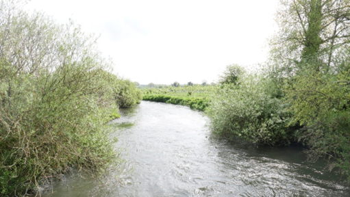
2.1.2 The area lies to the east side of the county town of Dorchester in Dorset. The main road (the A352) connecting Dorchester to Wareham and the Purbecks just touches the Neighbourhood Plan area to the south-west, and the London to Weymouth railway runs east–west through the centre of the Neighbourhood Plan area. The River Frome, which flows into Poole Harbour, runs along the northern edge of the area, with the exception of Tincleton parish, which is on the far side of the river.
2.1.3 Tincleton parish is located in the north of the Neighbourhood Plan area, closest to the larger village of Puddletown, which lies approximately 1½ miles to the north-west. The village of Tincleton is somewhat fragmented, with development around the junction at Tincleton Cross to the west, around the church to the east, and in between around the village hall on the junction with Blacksmith’s Lane. There is also a cluster of 25 homes at Clyffe House.
2.1.4 West Knighton is the largest parish in terms of population. It is located south of the River Frome and West Stafford, and west of Woodsford and Crossways. The village of West Knighton lies on the southern edge of the parish, close to the larger village of Broadmayne, which lies to the south. Lewell and Knighton Heath are to the north of the parish, and Littlemayne is to the south-west. The population of West Knighton is about 320.
2.1.5 West Stafford parish adjoins the easternmost part of Dorchester, with a population of about 310 people. The village of West Stafford is the second largest in the Neighbourhood Plan area. It is located between the grounds of Stafford House (to the north) and the railway line (to the south).
2.1.6 Woodsford parish is located south of Tincleton and east of West Knighton and West Stafford, with a population of about 80 people. The main cluster of housing is around Woodsford Church, on the northern side of the parish. The railway line runs along the southern boundary, with the larger village of Crossways to the south.
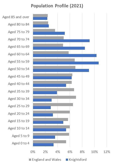
2.2.1 The population of Knightsford is about 900 according to the 2021 Census data, with West Knighton being the largest community and Woodsford the smallest. The population comprises mainly older people. The number of people in their 20s and 30s is significantly lower than the national average.
2.2.2 Most of the housing in the area comprises three- and four-bedroom family homes (accounting for about 81% of the overall housing stock). There are no apartments, only a handful of shared or sub-divided homes, and comparatively few terraced properties. These factors, together with generally high house prices across Southern England, mean that the average house price over the past five years (2018–2023) has been around £410,000, with the lower quartile price around £290,000.
2.2.3 Given its rural nature, the area has a limited range of community facilities. These include two village halls (in Tincleton and West Stafford), two pubs (in West Knighton and West Stafford), two play areas (in West Knighton and West Stafford), and churches in every parish.
2.2.4 Whilst the parish is not considered ‘deprived’, like many parts of rural Dorset it scores poorly when assessed against access to housing and services (based on the Government’s Indices of Multiple Deprivation).
2.2.5 There are no large industrial estates or leisure resorts in the area. The main businesses are working farms, quarrying, and construction-related activities. Part of Silverlake lies within the parish, an exclusive holiday home development based in a ‘worked out’ quarry where wildlife-rich areas and freshwater lakes have been created. Additionally, a limited range of small, largely independent businesses operate in the parish. It is estimated (based on responses to the 2022 household survey) that about 33% of workers work from home, about 50% work outside the area, and the remainder (about 10–15%) work locally.
2.3.1 The countryside is mainly pasture, bisected by the River Frome. There is a mix of farmland and heath covering much of the area, particularly to the south of the railway line.
2.3.2 There are over 60 listed buildings or structures within the Neighbourhood Plan area, five of which are Grade I and one Grade II*. There are also eight scheduled monuments in the area, mainly barrows. Conservation Areas have been designated covering much of West Knighton and West Stafford, highlighting and protecting the historic importance and character of these villages. The parkland around Stafford House is included on the local list of historic parks and gardens.
2.3.3 The River Frome is designated as a Site of Special Scientific Interest (SSSI). There are two small areas of ancient woodland along the northern boundary of Tincleton Parish, as well as several areas of deciduous woodland, including Knighton Heath Wood, Heron Grove, Gould’s Coppice, and woodland along the River Frome valley. These woodland areas, together with semi-improved grasslands, water meadows, and miles of hedgerows, provide important habitats for wildlife.
2.3.4 Just outside the Neighbourhood Plan area in Crossways parish lies Warmwell Heath, part of the Dorset Heathlands, which are designated as an SSSI and also have European and international designations (RAMSAR, SAC and SPA). The recreational impact of disturbance and trampling from visitors to these heaths is known to harm the wildlife there. The area also falls within the river catchment basin of Poole Harbour, which is similarly protected as an internationally important wildlife site. The impact from nutrients (nitrogen and phosphate) through the discharge of wastewater into the rivers that feed into Poole Harbour is known to be harmful to the ecology of that site and will also require mitigation.
2.3.5 Land underneath West Stafford, West Knighton and Tincleton contains an important aquifer, which is vulnerable to pollution. Much of the area is therefore designated as Source Protection and Drinking Water (Groundwater) Safeguarding Zonessup1.
2.3.6 Flood risk is a key consideration for much of the area, particularly in relation to the River Frome and its floodplain, but also in terms of susceptibility to groundwater flooding. A map showing flood risk areas is provided in Appendix 2. For further information on flood risk, please refer to the latest version of Dorset Council’s Strategic Flood Risk Assessment2.
2.3.7 Key environmental issues for our area, identified through the Strategic Environmental Assessment, include:
2.4.1 The West Dorset, Weymouth and Portland Local Plan (2015) contains the main strategic planning policies for the area. There is also a Minerals Strategy (2014), which forms part of the development plan, together with the more recently adopted Minerals Site and Waste Plans.
2.4.2 The main settlement in the area (in planning terms) is West Knighton, which has a defined development boundary. The villages of Broadmayne and West Knighton are considered together as one “larger village” in the Local Plan (Broadmayne lies in a different parish outside the Neighbourhood Plan area to the south).
2.4.3 The Local Plan’s spatial strategy (SUS2) states that “Development opportunities in the more rural areas will be focused primarily at the larger villages, and should take place at an appropriate scale to the size of the village (unless identified as a strategic allocation). It is expected that neighbourhood development plans and other appropriate planning tools will be used to help bring forward new development, and may allocate additional sites, or extend an existing (or add a new) development boundary to help deliver this growth.” The defined development boundary currently marks the area within which further development can generally take place, and the Local Plan also allows proposals for affordable housing, businesses and community facilities outside but adjoining this boundary.
2.4.4 The remaining area, including West Stafford, Woodsford and Tincleton, is treated as ‘countryside’ for planning purposes. Within these areas, the Local Plan’s spatial strategy states that “development will be strictly controlled, having particular regard to the need for the protection of the countryside and environmental constraints.”
2.4.5 The main development proposals for the area are included in the Minerals Site Plan, which allocates a large area of land (approximately 90ha) around Woodsford Lower Dairy as part of a north-easterly extension of the existing Woodsford quarry. The allocated site (AG4) has an estimated mineral resource of 3,000,000 tonnes of sand and gravel. A planning application to expand the quarry was made in August 2023 (P/FUL/2023/04753) and, as of the end of March 2025, had yet to be determined. In line with the allocation, it includes restoration plans to form a series of ponds that could help reduce phosphate, nitrogen and sediment load in the lower reaches of the River Frome SSSI and Poole Harbour SPA and Ramsar sites, as well as creating new wetland habitats, fishing areas, and a new footpath connection. It is estimated that, if granted, extraction of this area will not be completed until 2041.
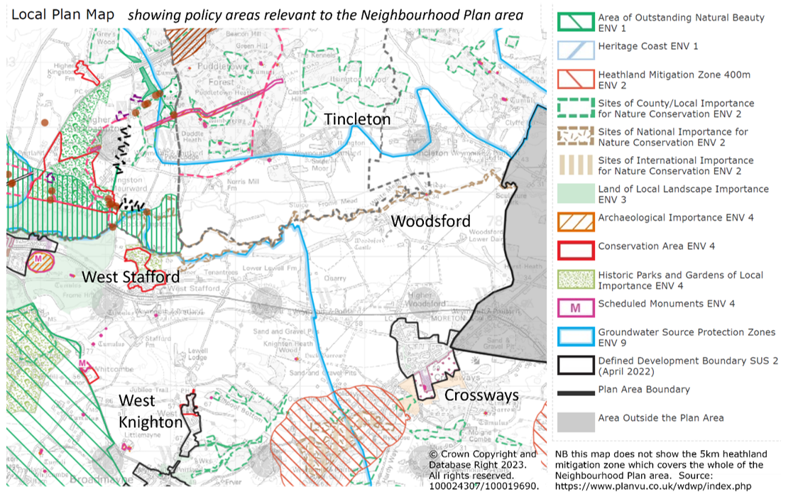
Map 2. Local Plan map for the area
2.4.6 Policy SUS5 of the Local Plan deals specifically with Neighbourhood Planning. This advises that Neighbourhood Plans should:
2.4.7 Work has commenced on the review of the Local Plan, and the first draft was published for consultation in January 2021. There were no strategic allocations proposed for the Neighbourhood Plan area in this first draft, and the spatial strategy was largely unchanged from the adopted Local Plan. The latest timetable for finalising the Local Plan (as of March 2025) indicates that it is likely to be adopted in late 2027.
2.5.1 We had some useful insights into resident’s priorities through the results of the consultations that were undertaken in 2022 and 2023.
2.5.2 As a whole, local residents told us that they want to live in an area which has retained its rural character, is friendly, safe and tranquil. Access to natural woodland and open green spaces, garden spaces, the many trees and hedgerows in the area, the historic buildings and use of local materials in designs, were all highly important. There was some support for additional housing and employment, which was explored further through looking at potential sites for development.
2.5.3 One of the ideas floated as part of the consultations for this Neighbourhood Plan was the potential for a community renewable energy project, that could provide renewable energy collectively to a village. Whilst there was a lot of support for this idea in responses to the 2022 Household Survey a follow-up question (sent directly to the potential volunteers via the contact details they provided) to ask if anyone would be willing to lead such a group did not get any positive responses, and in the absence of a group leader this project has not progressed.
2.5.4 Tincleton residents did not generally feel that further development in their parish was appropriate, as the area lacks the infrastructure, mains drainage, public transport, community facilities and road access to sustain any development. They felt that it was important to maintain the rural and historic character and tranquillity of the village and its open spaces. Concerns were raised about the increasing levels of traffic, and traffic speeds, and residents were supportive of measures to improve local routes for walkers, cyclists and horse riders. Whilst there was a desire to improve the village hall (including parking provision), there was no obvious options to do this through enabling development that would garner local support.
2.5.5 West Knighton residents were similarly keen to keep the rural feel, landscape and green spaces of the area, and protect the dark night skies. Almost everyone agreed that the village play area is a very important local asset which needs to be retained, and there was some support for the idea of a village hall, although at present residents can meet in the church and function rooms at the New Inn. Feedback from the consultations indicated that many residents believed that any development that does take place should not be extensive in size, but limited development either as infilling within the designated development boundary, or on brown field sites, could be accommodated provided this was done in a way that maintains the rural nature of the village. There were concerns raised about the number of homes used as second homes and holiday accommodation and how this may be impacting on the community, although the 2021 Census data does not indicate that this is particularly high compared to other parts of the county. Residents were particularly concerned about traffic on local roads, and how this affected the safe passage of walkers, cyclists and horse riders.
2.5.6 West Stafford residents were keen to keep the parish rural, tranquil, friendly, attractive, and safe. There was also a desire to respect the historic and rural character of the parish and retain the dark night skies. Local green spaces and views were seen as particularly important to the village, such as those over the water meadows and towards the church, and there was support for improving the walking, cycling, and riding routes between neighbouring parishes. There was also some support for the idea of a local shop / farm shop, but it is difficult to see that this would be viable given the lack of passing trade. No sites were put forward that were considered suitable for building on.
2.5.7 Woodsford residents broadly supported the overall objectives set out in the draft plan. There were no sites considered suitable for development, and the area lacks the infrastructure, services and facilities to make it a sustainable location for much development. Residents felt strongly about keeping the individual, rural and historic character of our villages, the views across the countryside to the church and other local features, and retaining the dark night skies.
1 https://magic.defra.gov.uk/MagicMap.aspx
2 https://www.dorsetcouncil.gov.uk/w/dorset-council-level-1-sfra, as published March 2024.
< Previous | ^ Top | Next >