
Tincleton village is located in the meadows of the River Frome valley, along and around Ilchester Road, and includes the cluster of development around Clyffe House. On the 1888 Ordnance Survey the village comprises farmsteads with the Church of St John, rectory, a school and post office to the south east. There is a complex series of drains to the south of the settlement within the agricultural fields. On later maps watercress beds appear to the south-west. The settlement and valley appear to have changed little during the 20th and 21st centuries, apart from the significant development in and around Clyffe House.
Road network, public rights of way
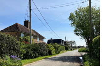
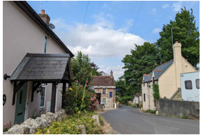
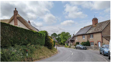
All roads have the character of countryside lanes, most are narrow (approximately 2m wide) one-lane roads permitting two-way travel. There are no pavements. The lanes are, in some places, bordered with rich vegetation, hedgerows, trees and green verges creating strong enclosure. However this is juxtaposed in other places in the parish by long views across fields, providing a feeling of openness. There is also a good network of public footpaths, offering access to the countryside around the village, and up to the cluster of homes at Clyffe House and south-west to Woodsford.
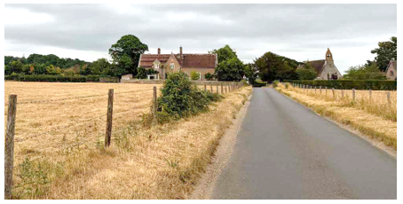
The long, straight nature of the road east west through the parish allows views of the Church and Old School from within the residential areas of the village. There are also views from the same road, looking north towards the local landmark of Clyffe House, and wider views of the Frome Valley from the network of footpaths to the north of the village.
Plot and boundary treatments
Buildings tend to be set back from the road with green front gardens and boundary treatments including hedgerows and vegetation as well as low stone walls and wooden fences. A high level of vegetation screens many buildings which further reduces the impact of the built environment on the landscape.
The cluster of development around the junction with Blacksmiths Lane has a more regular building line and rotation, softened with natural boundary treatments in the front and rear gardens.
Car parking
The dominant form of car parking is on plot, normally to the side of property, and occasionally to the front or rear.
Density
Tincleton has a relatively low building density, with generous gaps and abundant vegetation between buildings.
Building heights
Building heights are generally low, 1, 1½ and 2 storey buildings, the only taller buildings being the church and agricultural barns. Due to the variety of building types, these create an interesting and varied, if somewhat scattered, roofline.
Building forms and styles
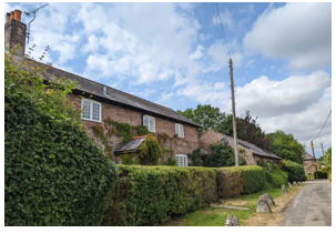
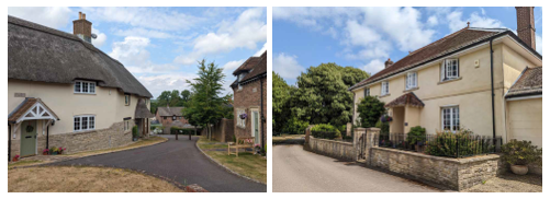
Tincleton has a rich local vernacular, with buildings of differing ages and designs. There are a variety of building typologies, the dominant being Victorian properties including farm workers houses, the church, rectory and school. Buildings are often detached or semi-detached and building line and orientation is often irregular with large gaps between buildings reflecting the village’s rural character.
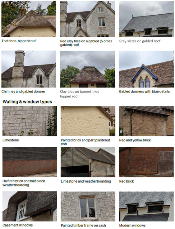
Roof materials & types
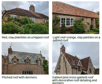
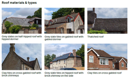
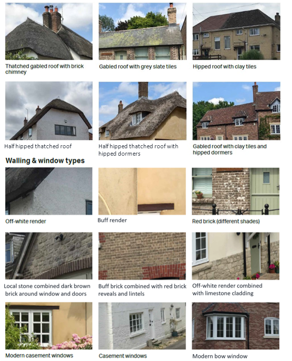
Tiled roofs are the most common roof type, with examples of clay rosemary tiles and slate tile and less often clay pantile. There are two thatched roofs, though some original thatch roofs have been converted.
Roof types range between gabled, cross gabled and hipped roofs in grey and brown plain tile, pantile and thatch. Dormers, chimneys and porches with pitched roofs add interest together with other decorative roofing features on some buildings.
Colour Palette, walling & window types
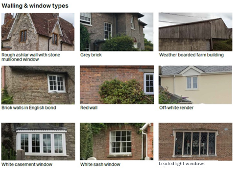
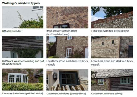
In the main, residential properties are constructed of red or grey brick or stone. Some have a white render finish, and some have tile hung elevations Farm buildings are mainly built by weatherboarding, red brick or stone. The church, old school and the old post office, now a listed residential property, have rough ashlar walls.
The bungalows built in precast concrete blocks do not reflect the character of the parish.
There is a consistent window style of white, vertically proportioned either casement or sash windows with white rectangular panels. Darker painted frames are seen, but are less common. The old post office, old school and church all have stone mullioned windows. The old post office has Crittall windows which is not seen elsewhere in the parish, but both the old school and church have leaded-light glazing which can also be seen in other properties.
The village is situated on elevated ground on the edge of a gravel plateau. The settlement was historically linear in plan, running north south. On the 1888 Ordnance Survey West Knighton is shown comprising St Peter’s Church, rectory, a smithy, a school, West Knighton farm, Higher Lewell Farm and the New Inn. The 1901 OS map shows little change from the 1888 OS map. Post-war there has been significant residential development to the south of the village, sprawling towards Broadmayne outside the Knightsford Parish study area.
The historic core of the settlement has been maintained, designated as a conservation area, and the Conservation Area Appraisal should be referenced for more detail with regard to development in this area.
Road network and public rights of way
Within the village, the streets within the historic core of the village have a meandering character bordered by green verges but no pavements. The late 20th century cul-de-sac developments, such as along Lewell Way, Glebe Way and Oakwood, are slightly more suburban in character with pavements and narrow green verges in places.
There is a good network of public footpaths and bridleways, connecting to West Stafford to the north, Broadmayne to the south, and allowing access to the wider countryside. There are also several footpath connections within the village itself that allow for shortcuts (such as to the church and First School).
There are a number of noteworthy views from Highgate Lane, as well as views across the open fields surrounding the village from the wider network of footpaths and bridleways.
Plot and boundary treatments
Buildings are typically set along the rural lane, with no or small setbacks, or are arranged in short cul-de-sac layouts. The informality and variation enhance the rural feel of the area. In addition to this, the topography, as the ground slopes down along Highgate Lane with Knighton Lane being the highest point, adds to the general environment allowing for evolving views along the streetscape.
There is a mixture of boundary treatments including both soft, (hedges, hedgerows, trees and flower beds), and hard surfaces. The latter include low-height brick or stone walls, black iron railings and timber fencing. Properties facing directly onto the streets are also considered as part of the boundary treatments adding interest along the streetscape.
Car parking
The majority of properties have car parking facilities within their boundaries or on the newer roads, particularly Lewell Way, Glebe Close, Oakwood etc. Parking laybys are also present but in places have impacted negatively on the sequence of attractive views as seen along the highway.
Density
Plot sizes and widths vary. Within the historic core the average density is relatively higher (although still well below that found in towns), dropping towards the edge where there are wider gaps between properties.
Building heights
The majority of properties are 1½ or 2 storeys, although there are a few post-war bungalows in the village. The tower of St Peter’s Church is the highest element within the village.
Building forms and styles
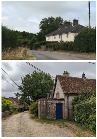
Within the older parts of the village, the majority of buildings are simple cottages. The farmhouses tend to be grander, as are the former school and the public house. There are a number of traditional farm buildings, including converted barns, cart sheds and a converted granary. Short terraces of cottages are set facing onto the road, but there are also more modern courtyard-style developments occupying old farmyards.
The Conservation Area Appraisal notes that architectural details are basically simple, with a pattern of irregular door and window openings in older cottages and more symmetrical, designed openings in the more gentrified homes and modern architecture.
The modern estates are dominated by larger houses set in the middle of their plots, with less variation, typical of the more generic styles of their time.
Roof materials & types
The topography, the meandering character of the streets and rich vegetation within the historic core of West Knighton village create interesting rooflines of varied character. In contrast, the more recent developments present more uniform rooflines with little variation, and this should be avoided.
The prevailing roof types are gabled and thatched, although there are also examples of other roof forms, including cross gabled roofs. Other features such as chimneys and dormers add interest to the rooflines. Those characteristics result in generally irregular rooflines which are often interrupted with vegetation.
Roof materials range between grey slate tiles and clay tiles, while there are also examples of thatched roofs. Chimneys, of red or dark brown engineering brick, and gabled or hipped dormers are also found adding visual interest.
Colour Palette, walling & window types
Materials range between renders (traditionally applied to cob walling), of off-white and other pastel colours, as well as buff, red and dark brown brick, Purbeck stone and other local limestone. There are also examples where materials are combined for instance, renders with Purbeck stone to the bottom, or bricks of different colours.
Window types include mainly casement windows, while there are also examples of sash and bow windows.
The more recent developments show less variety in material palette and style, which should be avoided.
The village of West Stafford sits on elevated ground bringing it above the River Frome’s floodplain. The village is nucleated with a defined historic core. On the 1888 Ordnance Survey the village is shown to comprise Frome dairy to the west, The Church of St Andrew, rectory, and school, with Manor Farm and Stafford dairy to the east and Stafford House to the north.
The historic core of the village appears little changed, and the Conservation Area Appraisal22 should be referenced for more detail with regard to development in this area. More recent development has occurred on the south side of the village.
Road network and public rights of way
Within the village, roads retain their rural quality with green verges and, in some cases, pavements on one side of the road. The topography and meandering nature of the lanes adds interest and variety to the environment, providing evolving views as you pass through the village, although traffic on the main thoroughfare can make walking, cycling and horse riding along that road seem dangerous.
There are a number of important views into and through the village from the main route through the village, as well as the setting of Stafford House. The village hall, pub and the church act as focal points. Views of the river and associated meadows can be seen from a number of rights of way.
The network of public footpaths and bridleways provide access to the countryside, as well as connecting to Dorchester and West Knighton. There are also several footpaths within the village allowing pedestrians easier access through the village.
Plot and boundary treatments
There is variety in terms of how many buildings are setback from the highway, with some fronting directly onto the lane, others allowing space for front gardens of varying sizes. Building lines, rotation, plot sizes and widths are very irregular in the historic core, and slightly more consistent within the more recently developed part of the village to the south. This informality contributes to the rural character of the village, and in general grass verges and/or front lawns and low front walls are encouraged to ensure an open, rural feel is maintained.
There is a mixture of boundary treatments, including native hedgerows, trees and flower beds, low-height brick or stone walls, black iron railings and wooden picket fencing. Properties facing directly onto the streets are also considered as part of the boundary treatments adding interest along the streetscape.
Car parking
Generally car parking spaces are either on the plot to the front or garage parking, although there are also examples of courtyard parking and on-street parking.
Density
The village has a generally compact character. Some of the 20th century development on the southern side of the village is set within more generous plots allowing larger gaps between buildings, promoting a greater sense of openness, particularly where building heights remain low.
Building heights
The average building height is generally low, around 2 storeys, while there are examples of bungalows. The Conservation Area appraisal notes that the whole of the main route, from Church Cottages to The Wise Man and the Village Hall, has a unity of scale. The spine of St Andrew’s Church is the highest element within the village. The topography, the meandering character of the streets and rich vegetation create interesting rooflines within the village settlement.
Building forms and styles
The village has a range of large detached and semi-detached properties, terraced housing, cottages and bungalows. Historically, many of the smaller cottages had simple one storey plus attics plans around a central entrance lobby, with chimneys at both ends. There are also several former agricultural buildings, most notably Barton Barn. A mix of house types characteristic of the historic part of the village is seen as important, with the 2002 Village Design Statement emphasising the need to avoid monotonous repetitions and avoidance of suburban, executive-style housing.
Floyers Field in West Stafford provides a good example of where modern development has complimented the historic built forms, although the loss of the view over rooftops to the church tower and water meadows (as lauded in the Conservation Area Appraisal) was unfortunate.
Roof materials & types
Roof materials include grey slate tiles and clay tiles, while there are also examples of thatched roofs. The prevailing roof types are gabled and thatched, while there are also examples of cross gabled roofs. Larger Purbeck stone tiles feature as the lowest course on some of the traditional buildings.
Roof pitches are typically between 37.5 to 47.5 degrees, and at least 50 degrees on thatched properties.
Chimneys, constructed of red or dark brown brick are common and should be included wherever possible. Some roofs have modest-sized gabled or hipped dormers. Ornamental ridge tiles and the use of scalloped tiles in decorative bands are also a notable feature.
Colour Palette, walling & window types
Wall materials are typically either rendered (traditionally cob, off-white and other pastel colours), Portland or Purbeck limestone or buff, red and dark brown brick. Stone and thatch tend to dominate the main thoroughfare. There are also examples where materials are combined, for instance, renders with random or coursed rubble to the bottom, or bricks of different colours used as quoins, lintels, architraves and sills.
Windows are mainly casement, although there are examples of sash and bow windows. More modern developments mostly maintain the typology and white colours on the frames.
Doors are generally wooden, with rain hoods and porches also a common feature, using identical materials to the main roof.
Woodsford is located in the rising ground south of the River Frome and water meadows. It appears on the 1888 Ordnance Survey subdivided into East and West Woodsford. East Woodsford is the larger of the two, concentrated around Woodsford Church. West Woodsford comprises Woodsford Castle, Castle Dairy, and cottages to the east.
Road network and Public Rights of Way
The countryside lanes are narrow, and well-vegetated with hedgerows, trees and green verges creating a strong sense of enclosure. There are no pavements. The public footpath network offers connections to Tincleton and Crossways, as well as to the River Frome.
There are various attractive, long-distance views from the road and rights of way network, including The Castle, which although slightly set back from the road, is quite visible and acts as a local landmark for the area.
Plot and boundary treatments
Buildings are typically set back from the main rural routes through the area, often down short cul-de-sacs, allowing for generous green buffers. Building orientations, spacing and building lines are very irregular, contributing to the rural feel and visual interest through unexpected views.
Native hedgerows are the main boundary treatments, although there are examples of low-height stone walls and post and rail wooden fencing.
Car parking
Car parking is typically within the plot either in front or to the side of the main property or garage parking.
Density
The building density is relatively low, with generous gaps between buildings, creating open views to the wider countryside.
Building heights
The average building height is generally low, around 2 storeys, while there are examples of 1-storey houses and barn buildings. There are a few taller buildings: the church, Woodsford Castle and some relatively modern, industrial-style barns.
Building forms and styles
7.2.5 Building types include traditional cottages, terraced farmworker cottages and barns, farm/manor houses, barns, as well as a mix of 20th century bungalows, post-war council houses and more modern, late 20th century homes.
Roof materials & types
Roof types range between gabled, cross gabled, hipped and thatched roofs. Roof materials range between clay tiles and grey slate, while there are also examples of thatched roofs. Chimneys, made of brick or limestone, and gabled dormers also decorate the roofs adding visual interest.
Colour Palette, walling & window types
Walls are typically limestone or buff and red brick (sometimes painted). Farm buildings are mainly built by weatherboarding, red brick and limestone.
Window types include painted timber-framed casement and sash windows. Occasionally some of the more modern developments have used darker colours or minimum details on the frames.
21 Osmington, West Knighton, West Stafford and Owermoigne Conservation Area Appraisal, January 2007 https://www.dorsetcouncil.gov.uk/-/conservation-areas-west-dorset
22 Osmington, West Knighton, West Stafford and Owermoigne Conservation Area Appraisal, January 2007 https://www.dorsetcouncil.gov.uk/-/conservation-areas-west-dorset
< Previous | ^ Top | Next >