
As the Locality Act came into force in 2011, Holwell Parish Council agreed to prepare a Neighbourhood Plan for the parish. A Working Group was set up consisting of Parish Councillors and other parishioners who were interested in taking part in this project. They agreed that producing a Neighbourhood Plan would allow us, as a community, to influence what happens in our Parish in the future. Neighbourhood plans are used to decide the future of the places where residents live and work and include choosing places to build new homes and other types of buildings. They can say what these new buildings should look like and where certain land might be used for different purposes, such as recreation areas.
When approved, our Neighbourhood Plan becomes part of the Local Development Plan and its policies will work alongside the policies in the Local Plan in our parish. Although it has to be in line with the Local Plan’s strategy for the area, a Neighbourhood Plan can make significant changes to the approach taken in the Local Plan. In our plan we have:
The Local plan is the West Dorset, Weymouth and Portland Local Plan 2011-2031; it was adopted in October 2015. The Local Plan is valid until 2031 and is currently being reviewed. It states that although a lot of demand for new housing exists in the rural areas such as Holwell, there are problems associated with providing more housing in places that have few jobs or facilities. The resulting dependency on cars inevitably increases carbon emissions and disadvantages those who don’t have a car (usually the more vulnerable groups in our society), which is why it makes sense to try to focus development on the towns. As each village will be different in terms of its needs, opportunities and constraints, the Local Plan allows a more enabling approach for rural communities – working with those that want to see development take place so they can identify suitable sites to meet their local needs. Using neighbourhood development plans and other planning tools, communities can allocate sites, introduce or extend a development boundary, or develop a criteria-based policy to allow development to take place, where they consider this is the right approach for them.
Policy SUS2 of the Local Plan, DISTRIBUTION OF DEVELOPMENT, states that development will be distributed according to a settlement hierarchy. Away from settlements, development will be strictly controlled, having particular regard to the need for the protection of the countryside and environmental constraints. Holwell has no defined settlement boundary, and new sites within or on the edge of the settlement are therefore unlikely to be approved for open market housing without a Neighbourhood Plan. New employment premises, community facilities, and affordable housing would still be considered favourably, subject to certain criteria being met.
Following the launch by the Parish Council in 2011 the Working Group initially prepared some scoping studies around Housing, Employment and Business, Roads and Transport, Environment and Community. From 22nd October 2015, a new Chair took over and initially focused on ensuring that there was a clear vision and aims for the Working Group and Plan. The Group also agreed a set of Terms of Reference and a set of Principles in Public Life and all documents were reviewed and published in early 2016.
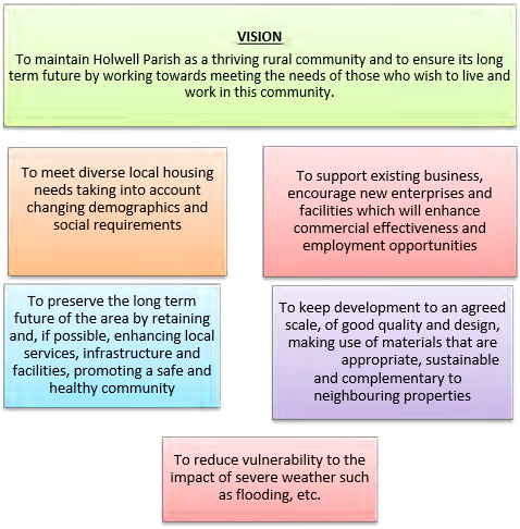
The Working Group prepared a Vision and set of Strategic Objectives, published in January 2016, to guide their work on the Neighbourhood Plan. These are shown below:
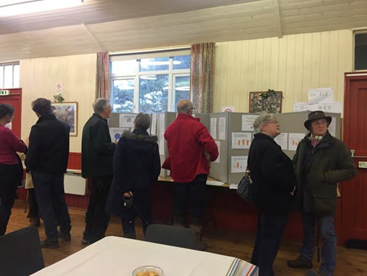
In April 2016, the Group held initial Village Consultation sessions for the residents asking them to define what they felt were the key issues that a Plan should address. The results of this Scoping consultation were used to create a more focused household questionnaire which was hand delivered to and collected from every household in October and November 2016. Further Village Consultation sessions were then held in December 2016 so residents could see what the responses said. All this information was also posted on the Neighbourhood Plan section of the Parish Council web site to ensure the widest coverage. For both of these consultation processes, the level of involvement was good Details of the responses are available in the Consultation Process documentation.
In parallel, a formal notice was issued, asking landowners whether they had sites that they wished to be considered as part of the process. The Group prepared a set of Site Assessment criteria and a set of Assessment Scoring criteria so that each site could be reviewed and scored.
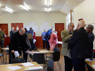
Initially 19 sites were put forward with a further 5 being submitted during the assessment period, giving a total of 24 sites for consideration. The site assessments were undertaken using the Site Assessment criteria and Scoring methods at a meeting in April 2017 and at two meetings in May 2017. These resulted in three groups of sites that either met the criteria well or met the criteria in most areas, or did not meet the criteria. These proposals were then displayed at open meetings in July, August and September 2017 so that residents could make their own decisions on the information displayed and give their opinion and comments on which sites they would prefer to see put into the Plan document for development.
Help was provided by Oliver Rendle, Environmental Assessment Officer at the Dorset Combined Councils who produced a Screening Assessment to determine whether or not the Holwell Neighbourhood Plan required a Strategic Environmental Assessment (SEA) through a process known as SEA screening. The report provided an account of the SEA screening exercise for the Holwell Neighbourhood Plan and, following the consultation, the SEA screening report concluded that the Holwell SEA is unlikely to result in significant environmental impacts and therefore a full SEA was not required in this instance. The Screening Report is included as part of the Plan Submission pack.
The Working Group undertook evidence collection through a range of means and by a number of the Working Group. Examples include speaking to local business people and key stakeholders such as the Three Valleys Benefice Team Vicar, local farmers etc. A grant was secured from Locality to commission a Heritage and Character report from AECOM to help provide an external view of what to value about Holwell during this Neighbourhood Plan process. Various members of the Working Group provided significant input on the environment, on places or views of key interest, and also on the impact of potential flooding to the parish. A report on Planning Design Guidelines was also produced, again produced by AECOM, to propose sensitive treatment of any proposed development such that it retains and enhances the look and feel of Holwell’s buildings and environment. These reports are included as Appendices P1 and P2.
The Working Group started drafting the Plan documents using the evidence collected during the two consultation sessions, from nationally available statistical data, from reference documents, from meetings with stakeholders, and the reports supplied through grant funding and with the help of Jo Witherden, Dorset Planning Consultant to help draft policies that reflect the community’s views.
The Working Group had agreed the proposed method to be used to analyse the responses received so that the outcome of the number of sites selected was in line with all those who had responded. The responses to the Site Options Consultation were reviewed by the Working Group at a meeting on 18th January 2018 giving the detailed calculations that had been made to ensure that we put forward sites in line with residents’ responses. The final number and details of sites were then confirmed with the group. They also reviewed all the comments made and agreed actions. It was agreed that we would hold consultation meetings with residents to allow them to provide feedback on the outcomes and also to review a draft of the Plan prior to any formal consultation process. Open meetings were in March 2018 so that residents could see (a) what the plan looked like and (b) the sites selected after the finalisation of the Site Options Questionnaire results, and all the plan documents displayed at the meetings were put online.
The formal consultation period for the Pre Submission Draft Plan ran from 21st May to 9th July 2018. The consultation was widely publicised and statutory and other consultees were contacted for their input. During this period three open consultation sessions were held for residents to review hard copies of the documents and speak to Working Group members. In early August 2018 the revised plan and all the necessary supporting documents were submitted for examination.
West Dorset District Council was then required to consult on the plan proposals before the examination could take place. That consultation process ran from 6th September to 19th October 2018, giving individuals and organisations the opportunity to raise any concerns they still had about the plan with regard to the content and how it has been prepared. An independent examiner, Andrew Mead BSc (Hons) MRTPI MIQ, was appointed and produced his examination report on 28th November 2018. He made eight recommendations to modify a number of policies to ensure the Plan meets the Basic Conditions and other legal requirements, and confirmed that, once modified, the Plan should proceed to referendum. He remarked on the commendable extent of contact with the public and the Parish Council during the preparation of the Plan, and congratulated the Working Group and the Parish Council for their efforts in producing a comprehensive and well-illustrated document.
West Dorset District Council considered each of the recommendations and modifications contained in the Examiner’s report and agreed the amendments at its Strategy Committee on 13 December 2018.
The first ever referendum for the Holwell Neighbourhood Plan was held on 7th February 2019. From an electorate of 302 there was a turnout of 133 (44%). The result; votes in favour 109 (82%) and votes against 24 (18%).
At the meeting of the Full Council on 26th February 2019, West Dorset District Council took the decision to make the Holwell Neighbourhood Plan (as modified in accordance with the Examiner’s recommendations) part of the development plan for the Holwell Neighbourhood Area.
Whilst there is no requirement to review or update a neighbourhood plan, its policies may become out of date over time, and other material considerations may be given greater weight in planning decisions as the evidence base for the plan policy becomes less robust. Where the Local Planning Authority are not able to show that they have 5 years’ housing land supply (which was confirmed by Dorset Council to be the case in March 2020), a Neighbourhood Plan will only be given full weight when it is no more than 2 years old.
There are 3 types of modification which can be made to a neighbourhood plan. The process will depend on the degree of change which the modification involves:
Holwell Parish Council decided to review its Plan at the Council meeting in June 2020. A consultation was run in August and September 2020, to check whether local residents felt that the policies in the Plan were still appropriate for Holwell. The survey responses indicated that residents felt that there was no obvious need to amend the plan significantly, either by changing the existing policies or adding new policies. Any changes should simply reflect factual updates, such as the developments that have taken place since the plan was drafted.
This plan therefore has been updated to reflect factual updates, and does not propose any significant changes. The main changes are in relation to the housebuilding and planning permissions that have taken place since the plan was first drafted.
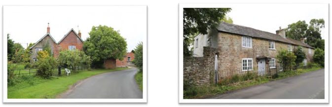
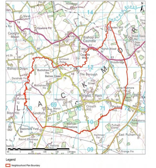
The Parish of Holwell (the designated Neighbourhood Plan area – see Figure 1) is located in West Dorset (now part of Dorset Council) and has a population of approximately 350 residents (2018 Mid Year Estimates, ONS, courtesy of Dorset Council). It covers approximately 10 square kilometres (or 2,400 acres) of gently undulating, mainly agricultural land. The main settlement of Holwell is focused around Fosters Hill, Crouch Hill, Pleck and Gunville, and the wider area comprises generally undeveloped, small clustered hamlets (including Holwell Borough; Buckshaw; The Manor and Sandhills; Westrow; Hill Street; Packers Hill and Piccadilly; and Woodbridge) and individual farmsteads. Although there are now significantly fewer smallholders and farms than in the 1900s, Holwell’s 9 working farms remain largely non-intensive, supporting a thriving wildlife community and distinctly rural environment which is much appreciated by its residents.
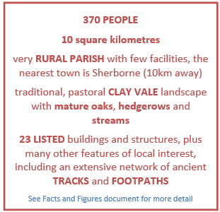
The surrounding landscape comprises chalk escarpments and limestone hills, as the parish borders the rolling hills and valleys of the Blackmore Vale, with views to Bulbarrow and the Dungeon Hills. The undulating land is largely Oxford Clay, drained by numerous small streams running north to join Caundle Brook, with an area of sandy loam at Sandhills.
Outside the parish the nearest settlements include Bishops Caundle to the north, Kings Stag to the east and Pulham to the south; these small settlements are set apart by large spans of agricultural land and patches of woodland and contribute to the remote, rural character of the area. Larger settlements are a further distance from Holwell including Sherborne 10km to the north west and Dorchester 25km to the south.
Figure 1: Parish of Holwell
Use of the words “Will” and “Should” Policies in this Plan are written to cater for a wide range of planning applications from small scale domestic extensions to larger scale development sites. For this reason, some flexibility needs to be built into the policy tests on occasion. Where the word “will” has been used, this means that the policy test must be complied with and it is not expected that there will be exceptions made to this policy. Where the word “should” is used, this means in general that is expected that the policy test will be met but recognises that there may be exceptions due to specific circumstances. It does not imply that the policy is optional. If an applicant considers that their case is an exception, it is recommended that they include information explaining the reasons why they consider such an exception be made. |
< Previous | ^ Top | Next >