
6.1 The aim of this Plan is to maintain the special nature of this area, its geological, palaeontological and environmental assets, and the character and heritage of the village. Ensuring that the designations in place are fully considered is one way of achieving this, as is a strong presumption against development that fails to conserve and enhance the natural beauty of this Area of Outstanding Natural Beauty (AONB), this being the primary purpose of that designation. Any development should protect the local landscape character and natural environmental assets, and enhance such local features, noting the internationally significant geology of the area. There is a need to protect the environment for residents, locals and visitors both national and international, for now and for future generations.
6.2 The Local Plan (LP) both in text and Policy LP-ENV1 supports that initial paragraph, noting the exceptional landscapes, views and sense of tranquillity. When referring to development, the LP refers to protection of the natural environment, requiring care to be taken of sensitive locations and recognition of potential adverse impact to landscape and ecology.
National Environmental Policy direction is being framed within the Government’s 25-year environment plan “A Green Future: Our 25 Year Plan to Improve the Environment”, published in 2018.
6.3 The 2015 report on Dorset’s Environmental Economy looked at how Dorset residents value the environment, with clear findings including:
6.4 Charmouth Parish is small: 221.1 Hectares (2.211 sq kms) or 546.349 Acres (0.854 sq miles). Natural areas within the parish are therefore considered very important to the residents. Approximately one third of the parish is within the built-up area, with the remainder comprising fields and other open areas as described in Landscape Characteristics below, and listed in the Green Audit (see link in Appendix E). The River Char runs down through the Parish out to sea; The Gwyle is a major tributary which marks part of the northern Parish boundary.
6.5 The special nature and importance of the Charmouth area and its environment has been recognised by a number of organisations and designations with the intention of providing protection for those assets.
6.6 Prior to being awarded World Heritage status by UNESCO in 2001, the area was already defined as the Dorset Heritage Coast, and even were World Heritage Site status to be lost for any reason, Heritage Coast status would continue. Heritage Coasts are protected through development control within the planning system.
Paragraph 173 of the National Planning Policy Framework (NPPF) and the supporting National Planning Policy Guidance (NPPG), provide the key protection for the WHS within the planning system. “Within areas defined as Heritage Coast (and that do not already fall within the one of the designated areas mentioned in paragraph 172 [which includes AONB]), planning policies and decisions should be consistent with the special character of the area and the importance of its conservation. Major development within a Heritage Coast is unlikely to be appropriate, unless it is compatible with its special character.”
6.7 NPPF emphasises that the presumption in favour of sustainable development should apply, “unless specific policies in this Framework indicate development should be restricted.” These ‘specific policies’ include those that refer to designated heritage assets. World Heritage Sites are defined as designated heritage assets in the NPPF and are therefore exempt from the presumption in favour of sustainable development.
6.8 World Heritage Site (WHS): Charmouth is one of the gateways to the Jurassic Coast, England’s first natural World Heritage Site, giving the area significant international recognition.
In 2001, the undeveloped cliffs and beaches between Orcombe Point near Exmouth in East Devon, and Studland Bay near Poole in Dorset were inscribed on the World Heritage List by the UNESCO World Heritage Committee. The Site was granted World Heritage Status under the criteria “Earth’s history and geological features” which indicates that its geology, palaeontology and geomorphology are of Outstanding Universal Value.
Management of this World Heritage Site is achieved through a partnership approach. The Jurassic Coast Trust is the body with delegated authority from UNESCO for the co-ordination and facilitation of Site management. Guidance from UNESCO describes the need to protect an area around a World Heritage Site, generally referred to as its setting.
Charmouth is situated about half way along the 95 mile World Heritage Site, and a key location for its Jurassic element: as such it attracts thousands of visitors every year, many of them from around the world.
(This is summarised in the ‘Jurassic Coast Trust Partnership Plan 2020-2025’.)
6.9 Of particular significance locally, conservation of the WHS is covered by the statutory Management Plan for the Dorset AONB (AONB MP). The special qualities of the AONB are important in understanding the setting of the WHS, and AONB policies provide some of the protection that negates the need for a buffer zone around the WHS.
6.10 Although the coast was not inscribed in the World Heritage list for its natural beauty, UNESCO recognises its value with respect to this creation as “nationally important”, justified further by the UK Government’s’ decades-long designation of the East Devon and Dorset Areas of Outstanding Natural Beauty (AONB), which covers more than 80% of the WHS area.
The special qualities of the AONBs, such as tranquillity and undeveloped character of coast and seascapes, are important for helping to determine how people experience and enjoy the setting of the WHS.
6.11 Area of Outstanding Natural Beauty (AONB) designation: Charmouth lies within the Dorset AONB, which is a landscape of national and international significance for its natural and cultural heritage assets, in an area known for its outstanding environmental quality. AONBs are defined as areas not in a National Park but considered to be of such outstanding natural beauty that it is desirable to protect them. The Government has confirmed that the landscape qualities of National Parks and AONBs are equivalent and current guidance makes it clear that the practical application of the natural beauty criterion is identical for both National Parks and AONBs, as is their equivalent importance and protection. Dorset AONB was designated in 1959 and is the 5th largest AONB in the UK, covering 1,129 sq kms (435.9 sq miles,) approximately 42% of the county. Geodiversity underpins the natural beauty for which the AONB is designated.
The ‘AONB MP’ states that “Local planning authorities have a statutory duty of regard for the primary purpose of the AONB to conserve and enhance natural beauty when making planning decisions.”
Paragraph 176 of NPPF states “Great weight should be given to conserving and enhancing landscape and scenic beauty in National Parks … and Areas of Outstanding Natural Beauty, which have the highest status of protection in relation to these issues. The conservation and enhancement of wildlife and cultural heritage are also important considerations in these areas, and should be given great weight in National Parks.’’
6.12 A mark of the area’s importance is the proposal to Natural England that the area become a national park. This proposal embraces the Dorset and East Devon Areas of Outstanding Natural Beauty (AONB) and is under serious consideration. A report written for Dorset County Council (March 2016) as part of the proposal valued the Dorset environment as worth some £1.5bn a year.
6.13 Site of Special Scientific Interest (SSSI) designation: Charmouth is part of the West Dorset Coast SSSI. The designation notes that the area between Chesil Beach and Devonshire Head near Lyme Regis is an internationally important geological site. The coastal cliffs and landslides at Charmouth comprise limestones and mudstones which are the richest source of Lower Jurassic reptiles, fish and insects anywhere in the world. The varied undercliffs have a wide range of habitats which support a number of rare plants and animals. Adjoining the coastline are unusually large areas of herb-rich grassland of a type now very restricted in occurrence. The reedbed by the shore at Charmouth is one of only three UK locations where a population of the freshwater snail Cochlicella barbara exists. In 1989 there had been a proposal to convert the reedbed to a car park which was dismissed.
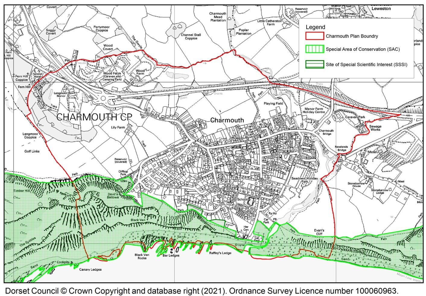
6.14 Special Area of Conservation (SAC) designation: Charmouth is part of the Sidmouth to West Bay Designated Special Area of Conservation (SAC UK00119864), a European designation. This area is an example of a highly unstable soft cliff coastline subject to mudslides and landslips. The principal rock types locally are soft mudstones, clays and silty limestones. It is subject to frequent mudslides in the waterlogged soft limestones and clays. Vegetation is very varied and includes pioneer communities on recent slips, calcareous grassland and extensive self–sown woodland dominated by ash and sycamore. The Habitats Regulations Assessment particularly notes the importance of SAC protection for Charmouth. See link to the HRA in Appendix E.
Map 6.1 Areas covered by SAC and SSSI
6.15 A requirement of the Basic Conditions Statement, is for the Neighbourhood Plan to contribute to the achievement of sustainable development, be compatible with EU obligations, and not likely to have a significant effect on a European wildlife site, (as defined in the Conservation of Habitats and Species Regulations 2012) or a European offshore marine site (as defined in the Offshore Marine Conservation (Natural Habitats) Regulations 2007).
In order to assess the likely impact on European wildlife sites, a Habitats Regulation Assessment (HRA) has been carried out by Dorset Council on behalf of the Neighbourhood Plan Steering Group. A link to the full HRA Report can be found in Appendix E.
6.16 An initial screening of possible European sites, within the immediate vicinity, that could be affected by the NP policies was considered. Certain sites were discounted from further consideration as no ‘pathways’ of impact were identified. Further evaluation of three Special Areas of Conservation (SAC) in Devon and Dorset were carried out. The result of the HRA screening concluded the Sidmouth to West Bay SAC was the only site that could be affected by this Plan.
6.17 The HRA Report stated that: “However, a likely significant effect [i.e. through development within Charmouth Parish] upon a European Site from the following three pathways could not be confidently ruled out”:
6.18 It was considered unlikely that the level of housing proposed in this Plan would result in a likely significant impact upon the Sidmouth to West Bay SAC.
However, proposed mitigations for these effects have been identified for the following draft policies: AA1, NE3, NE6, BET2, GA1, GA2 and CC2. These mitigations are contained in the following policy HRA1: Habitats Regulations.
POLICY HRA1: Habitats Regulations Any development carried out must not adversely affect the integrity of ‘Sidmouth to West Bay Special Area of Conservation’ in particular:
|
6.19 LP-ENV1 refers to “…the area’s exceptional landscapes and seascapes and geological interests”, which will be “protected, taking into account the objectives of the ‘Dorset AONB Management Plan’ and ‘World Heritage Site Management Plan’. Development which would harm the character, special qualities or natural beauty of the Dorset AONB or Heritage Coast, including their characteristic landscape quality and diversity, uninterrupted panoramic views, individual landmarks, and a sense of tranquillity and remoteness will not be permitted.”
6.20 In general terms, the ‘AONB Landscape Character Assessment 2019’ places Charmouth Parish predominantly within the Wootton Hills character area and partly within the Chideock Hills character area. These areas are of the same landscape type (evaluated by AONB as “strong”) and therefore share planning and management guidelines.
6.21 The ‘Charmouth Chideock and Seatown Conservation Area Appraisal’ (CCSCAA) adds more detail to the AONB character assessment: “The wider setting of Charmouth shows several characteristic elements, the proximity to a superb coastline of world fame, an inland landscape of riverside meadows and high hills capped and flanked with woodland and a more immediate context of fields and bypass to the north of the village. The historic core has a very obvious edge to the adjoining countryside, marked by a stone wall of unknown age and hedges, between back gardens, infill development and fields.”
6.22 Landscape Setting from ‘Dorset Historic Towns’ Survey’ (DHTS) says: “Charmouth lies on a steep east-facing slope running down to the edge of the River Char and its tributary to the east, The slopes become increasingly steep to the west. It lies just inland from the coast. The steep slopes dominate the setting.”
“The position of the town on a hillside exerts a strong visual influence on the town, adding variety to the visual experience of the town and providing good views over the town and surrounding landscape, particularly from higher up on the western side of Charmouth. Green spaces and trees form an important element in the urban fabric with many prominent trees mature trees within the centre of the town and many trees and mature planting in the suburban development to the south, obscuring much of the housing and softening the boundaries with the surrounding countryside.”
DHTS also notes: “The draft Historic Landscape Character mapping shows Charmouth sitting within an area of largely piecemeal enclosed fields and other regular enclosed fields, with open ground to the north around Hogchester and to the east around Stonebarrow. There are small areas of woodland on Timber Hill and Stonebarrow.”
6.23 In summary the landscape characteristics for the parish are listed in Table 6.1
Table 6.1 Distinctive Landscape Characteristics of Charmouth Parish
|
Sourced from AONB, CCSCAA, DHTS, and ‘Dorset Coast: Landscape and Seascape Character Assessment 2010’
6.24 Historically Charmouth and the landscape surrounding it have been considered outstanding. ‘A Guide to All the Watering and Sea-Bathing Places’ published in 1803 refers to “this delightful village”, which “occupies an elevated situation, and consequently commands many vast and beautiful prospects both of sea and land.” In 1803, on her visit to Charmouth, Jane Austen wrote “Charmouth, with its high grounds and extensive sweeps of country, and still more its sweet, retired bay, backed by dark cliffs, where fragments of low rock among the sands make it the happiest spot for watching the flow of tide, for sitting in unwearied contemplation.”
6.25 Despite the above description, the character of the beach changes on almost a daily basis, from sand to shingle to stretches of boulders; with the underlying ledges appearing and disappearing; with rockfalls and mudslides which are gradually washed away. This combination of landscape and the ever-changing shoreline makes Charmouth a special place. Bathing water quality was graded as excellent in 2018 and in 2019. It should be noted that, unusually, the beach is owned by the Parish Council, as well as its immediate hinterland.
6.26 The intent of this policy is therefore to ensure that while the village continues to evolve, the special nature of its landscape character must be considered valuable. Development should be in harmony with, and where possible conserve or enhance, the local landscape character as described above.
POLICY NE1: Landscape
|
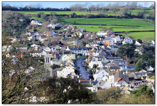
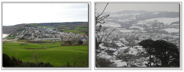
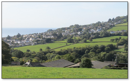
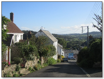
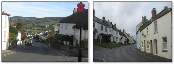
6.27 The village is closely bound between sea and land with rivers close to the east and north edges of the parish, and with land rising steeply both east and west of the village. The views and panoramas in all directions around Charmouth reflect its unique heritage of landscape and historical character. There are some excellent viewpoints from which to appreciate the village and its surrounds.
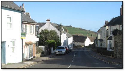
Views (a) from Stonebarrow looking west (b) from the top of Old Lyme Hill looking east
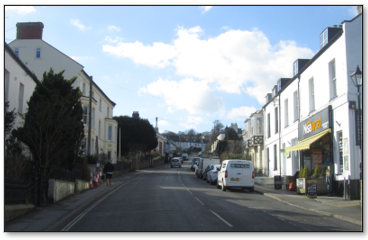
6.28 Much of ‘old Charmouth’ contains interesting historic buildings and provides picturesque views such as street views at local level. CCSCAA notes that “Key views and vistas are the progression of townscape experiences up and down The Street and Axminster Road; the wide views from the upper slopes of the higher ground to coast and countryside; the sudden transition on Barrs Lane to green space and the sight of the medieval boundaries of the burgage plots.” “There are odd landmarks like the Church tower and other visual focal points such as trees and there are glimpses up side passages and lanes as well as views of the wider countryside, adding up to a rich and complex sequence of spaces, views and other townscape experiences.” Chapter 4 provides more historical information.
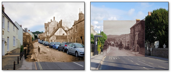
6.29 There are many views within the old part of the village which are still recognisable from the earliest photographs of the mid-1800s.
Then and now: (a) looking up The Street from outside the Abbots House/Queen’s Armes on the left (b) looking down The Street from opposite St Andrew’s Church (on the right)
6.30 Some quotes from VS re views:
6.31 DHTS charts the gradual process of development and infill from its earliest documented mention in the Domesday Book until the present day. The Charmouth Historic Urban Character Area evaluation from DHTS notes that much of the Conservation Area has a high sensitivity to major change. The scale and shape of the long narrow historic burgage plots reflect a planned layout of considerable time depth, which gives this part of Charmouth its character and any further erosion of the plot pattern would have a detrimental effect on the historic character.
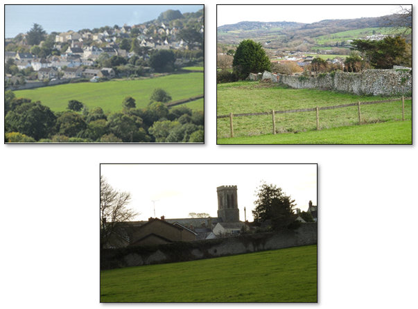
View of village from Catherston Leweston
6.32 The Old Priory Wall on the mediaeval boundary (the history of which is given in 4.3) marking the northern edge of the village is important to the village’s character and history. Good views of this Wall still exist and should be protected. Should any development take place close to the Wall not only would the Wall be hidden, but the concept of the village boundary Wall and its mediaeval roots would be lost. See Map 4.2.
6.33 Significantly, under the West Dorset District Plan of 2015, the Strategic Housing and Economic Land Availability Assessment (SHLAA) identified the area close to and outside the Wall as an area not to be built upon (WD/CHTH/002) and states: “Unacceptable impact on townscape and landscape as the site provides a soft edge to the village when viewed from the A35. Likely highway issues as there appears to be no suitable means of access. Likely impacts on the setting of the Conservation Area.” The 2020 SHLAA confirmed the unsuitability of the area. See paragraph 8.6.
6.34 The LP refers to views only in a very general manner while recognising that Dorset is a very picturesque county, and that local distinctiveness be protected and enhanced.
6.35 The ‘AONB MP’ states that “Development which has negative effects on the natural beauty of the AONB, its special qualities, ecosystem flows and natural processes is avoided.” Further, it requires that the quality of views into, within and out of the AONB is protected; and that the pattern of landscape features, including settlements that underpin local identity must also be protected.
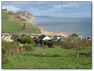
6.36 The parish has the good fortune to have wonderful views in all directions due to its hilly nature and coastal situation; long, panoramic views from the parish outwards in all directions; and views into the parish from neighbouring hills. These views across the countryside and seascape are available to everyone, contributing significantly both to the area’s special character and to the quality of life enjoyed by residents and its many visitors.
The importance of such views is recognised by the fact that where built development is proposed within an identified view, then a Landscape and Visual Impact Assessment (LVIA) including photomontages is required under ‘Planning Application Requirements April 2019’ to ensure the impact of the development is understood and that measures are identified to ensure the view is not diminished.
6.37 All wide views of and from the parish could be sensitive to the effects of development, with many views being altered little over the years. However the key views which this Plan aims to protect under this Plan have to be those local, more specific views where development would cause a negative impact. Holiday parks are visible in some wider views of the area, although some of these have taken care to plant trees and provide some screening.
MAP 6.2 Locally Important Views
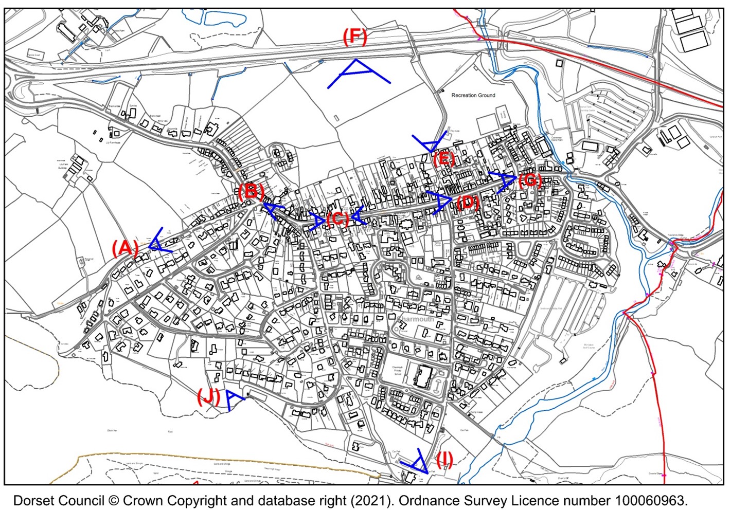
Table 6.2 Locally Important Views
|
View from |
View of = description/reason |
Reference if exists |
A |
Upper western edge of Conservation Area on Old Lyme Hill |
Looking down Old Lyme Hill. Also to hills in the distance. |
|
B |
Corner of The Street, Old Lyme Hill and Old Lyme Road, near The Pound |
View down The Street showing part of the ‘old village’, part of Conservation Area. The Pound is LGS3 |
|
C |
Knapp Green (corner The Street and Higher Sea Lane) |
Conservation Area views up, and down The Street over Charmouth. Also long views eastwards to Stonebarrow, Ryall and farther. Knapp Green is LGS4 |
CCSCAA |
D |
Corner of Lower Sea Lane and The Street |
View up The Street showing part of the ‘old village’, part of Conservation Area |
CCSCAA |
E |
Barrs Lane gap in the wall on mediaeval boundary |
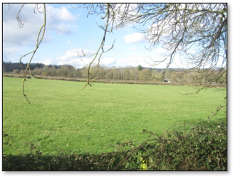
Looking north across fields
|
CCSCAA |
F |
Barrs Lane, and from footpath beside A35, and from A35 |
Continuous view across to the Abbey Wall. See photos at 6.33 |
SHLAA WD/CHTH/002 See 6.33 |
G |
Corner of Bridge Road and The Street |
View up The Street showing the lower part of the ‘old village’, part of Conservation Area |
CCSCAA |
I |
First view many tourists see get when they get out of their car near the shore. |
View up towards village on hillside |
|
J |
Turning circle at the top end of Higher Sea Lane |
View eastwards across the lower part of the village, down to the sea and along the coast |
|
View A: Looking down Old Lyme Hill from the top of the Conservation Area
View B: View down The Street showing part of the ‘old village’ from the Corner of The Street, Old Lyme Hill and Old Lyme Road
View C: Two photos taken from The Knapp(i) looking down The Street (ii) looking up The Street. A historical view down The Street from The Knapp can be seen as the ‘then and now’ at paragraph 4.5.
View D: View up The Street showing part of the ‘old village’ from the Corner of Lower Sea Lane and The Street. A ‘then and now’ historical version of this view can be seen at 4.5.
View E: Looking north across fields from the Barrs Lane gap in the wall on mediaeval boundary
Views F: Views of the Abbey Wall from (a) Catherston (b) near the foot of Nutcombe Terrace (c) Barrs Lane
View G: up The Street from near The George Inn
View I: The first view many tourists see when they get out of their car near the shore, looking up to the village.
View J: From the turning circle on Higher Sea Lane
6.38 Policy NE2 aims to protect those views and vistas which are available to all. There should be a presumption against any development which by its location or design would harm the appreciation of important views of or from the parish.
The design and layout of development should minimise adverse impacts on views from public rights of way over open countryside and preserve and enhance such views where possible. Development that would adversely affect the rural setting of the village (whether by scale, massing, design or location) will not be supported. See also Policy H4.
POLICY NE2: Views and Vistas
|
6.39 The varied landscape characteristics of Charmouth (6.19 to 6.26) give rise to a wide range of habitats for wildlife and thus good species biodiversity. The fields to the north and west of the village are largely used for pasture: cattle, sheep and meadow. A link to the Green Audit, listing all green areas within the Parish can be found in Appendix E.
6.40 Through its Management Plan the Dorset AONB Partnership is helping deliver the aspirations of ‘Biodiversity 2020’, which is the Government’s commitment to wildlife and ecosystems under the Convention on Biological Diversity. The mission for Biodiversity 2020 is “to halt overall biodiversity loss, support healthy well-functioning ecosystems and establish coherent ecological networks, with more and better places for nature for the benefit of wildlife and people”. The AONB Management Plan further states that development should “… avoid and reduce the impacts of development on biodiversity.”
6.41 LP-ENV2 states: “Proposals that conserve or enhance biodiversity should be supported. Opportunities to incorporate and enhance biodiversity in and around developments will be encouraged.”
6.42 A green corridor is generally a strip of land that provides sufficient habitat to support wildlife, and allows the movement of wildlife along it; while an ecological network provides linkages between such corridors creating a whole green infrastructure of spaces and linkages valuable for their wildlife, geological, landscape or historic importance.
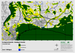
Map 6.3 Local Ecological Networks
6.43 NPPF paragraph 179 highlights the need “To protect and enhance biodiversity and geodiversity” and gives detailed instructions about identifying, mapping and safeguarding habitats including ecological networks.
The Dorset Environmental Records Centre (DERC) has mapped the ecological networks for the Parish (Map 6.3). Areas include, as expected, the areas with SSSI and SAC protection, the internationally designated area of the World Heritage Site, National Trust land, the sea, the river and river valley and inland water sites, hedgerows, wooded areas, wide verges and the churchyard. Those areas already recognised by DERC as existing ecological networks are shown in green. DERC has also mapped potential network sites shown in yellow, both wildlife corridors and stepping stones. Little has been identified within the built boundary, but a substantial area of the rest of the Parish either is, or has the potential to be, part of that network.
6.44 The AONB MP (9.3.4) states that “Developments will be required to make a positive contribution to the overall green infrastructure and ecological networks. All aspects of green infrastructure, e.g. sustainable drainage, also require good design that respects local character and must also make an appropriate contribution to landscape ecology. The net result of these contributions should be landscape gain.”
6.45 Gardens should not be forgotten as they are an important part of the ecological network. Charmouth contains some relatively large gardens, important for wildlife and part of an unmapped green network. See also 6.61
6.46 Several of the Parish’s Local Green Spaces are important to biodiversity as green corridors and stepping stones See 6.63 to 6.71 and Table 6.5 particularly LGS7 and LGS9.
6.47 LP Policies ENV2(vi) and ENV3(ii) not only support the idea of green infrastructure networks, but make the point that opportunities should be taken not just to protect the natural environment but to improve such ecological spaces and their biodiversity.
6.48 The A35 verges are recognised as important green corridors in a 2018 report written by Highways England in collaboration with Dorset Wildlife Trust, following the initiative of a local resident and landowner. Highways England has a duty to manage and maintain its verges and has stated: “Highways England is keen to manage road verges to benefit wild flowers and other nature. Dorset Wildlife Trust have confirmed through a species survey that a strong species mix is already present in the A35 verges at Charmouth. Designation as a Site of Nature Conservation Interest (SNCI) is a possible consideration, and the local community at Charmouth have expressed a strong desire to see these verges managed to enhance the wild flower population.” (See letter listed in App E – CNP A35 Report). See also 6.52.
6.49 There are green corridors around the village which if damaged or broken through, would impinge on the wildlife benefit they currently provide. Examples of this are LGS7 (wilderness beside track from Higher Sea Lane to Lookout Green) and Green Audit B5 (woodland from roundabout up to Fernhill, both sides of A3052.) The River Char and its tributaries provide excellent green corridors through and bounding the parish.
6.50 It is important to maintain or improve the semi-rural character and appearance of the parish by ensuring the existence of open areas which have amenity, environmental or other value. This means protecting green areas: green corridors, hedges, trees and verges, and linking one green area to another. The importance of not impairing or damaging the enjoyment, health benefits and recreational value of green areas must be recognised. Many comments in the VS support these views, for example:
6.51 Within this area, the diverse underlying geology and geomorphology processes are intrinsic to ecosystems delivery, influencing soils and hydrology, wildlife habitats, landform, land use and architecture that make up the character and distinctiveness of the landscape and support the current diversity of flora and fauna.
6.52 Various surveys have been undertaken in Charmouth Parish and close by, as well as records being made by individuals, identifying an excellent range of species. Many of these are under threat, rare or protected (see the ‘List of species and habitats of principal importance for biodiversity conservation’ as monitored by Natural England), or have Dorset Notable recognition. It must be noted that wildlife does not recognise boundaries and many species can travel considerable distances, so records from nearby are as valid as those from within the parish provided the terrain is suitable or green networks exist.
The species’ records include four protected mammal species including otter; ten protected bird species; 16 protected species of moths, butterflies and beetles. Records also include the majority of UK bat species, and in early 2021 the Bat Conservation Trust gained funding to research the rare Grey long-eared bat (Plecotus austriacus) locally. A total of around 350 species of moths were identified in Charmouth in 2019 (source: local resident with over 50 years’ experience of identifying and studying moths). Yellow meadow ants (Lasius flavus) have formed dozens of ant-hills in grassland west of Lookout Green (LGS9 in Table 6.1).
The 2018 Dorset Wildlife Trust survey of A35 verges (see 6.48) identified over 50 distinct plant species with no less than twelve of them being 'Dorset Notable' (which it is believed would be better than most local SSSI sites could claim). A link to the A35 Report can be found in Appendix E.
A surprisingly large number of trees and tree groupings within Charmouth have Tree Preservation Orders as can be seen on Map 6.4.
Map 6.4 Tree Preservation Orders and Veteran Trees
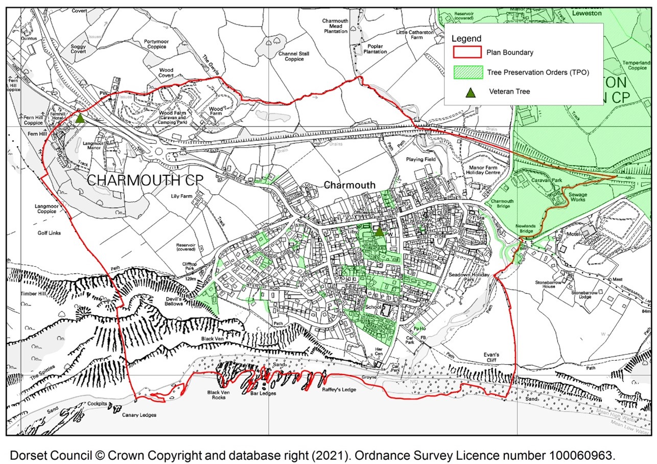
Tree Preservation Order (TPO): A Tree Preservation Order is an order made by a local planning authority in England to protect specific trees, groups of trees or woodlands in the interests of amenity.
Veteran Tree: A tree which, because of its great age, size or condition is of exceptional value for wildlife, in the landscape, or culturally.
6.53 The Conservation of Habitats and Species Regulations 2010 transpose (sic) certain prohibitions against activities affecting European Protected Species. These include prohibitions against the deliberate capturing, killing or disturbance and against the damage or destruction of a breeding site or resting place of such an animal.
See Appendix E for links to the DERC list of protected species found in the Parish, and to the Dorset Wildlife Trust survey of the A35 verges.
6.54 It is clear from the comments in the Village Survey that many residents are very positive about Charmouth’s environment. In particular, VS Reports Q1, Q4 and Q11, 14, 15 suggest a high level of support for protection of the natural environment.
6.55 The Wildlife Trusts say: “It’s possible to create nature-friendly housing by planting wildlife-rich community green spaces, walkways, gardens, verges, roofs, wetlands and other natural features. These gains for wildlife improve people’s health and quality of life too.” Their blueprint for new nature-friendly homes highlights the myriad of social, environmental and economic benefits of this approach.
Table 6.3 The Wildlife Trusts’ Blueprint
Benefits for wildlife |
Better protection for wildlife sites, more space for wildlife, improved connectivity and buildings that are more wildlife-friendly |
Benefits for residents |
Daily contact with nature, improved health, protection against climate extremes, safer transport routes, good sense of community |
Benefits for the economy and wider society |
Cost-effective environmental protection, employment, space to grow local food, healthier and happier communities putting less pressure on health and social services |
Benefits for developers |
Satisfied customers, market value, enhanced brand, improved recruitment, improved environmental ranking |
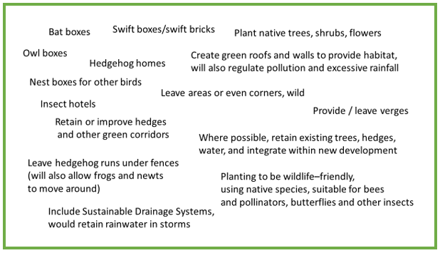
6.56 The inclusion of wildlife assistance measures in any development would thus be appropriate in this context. Most of the suggestions in Table 6.4 can be incorporated at little or no additional cost (Dorset Wildlife Trust and others).
Table 6.4 Wildlife Assistance Measures
6.57 LP-ENV2 states “In other locations, including locally identified wildlife sites and water-bodies, where significant harm to nature conservation interests cannot be avoided, it should be mitigated. Where it cannot be avoided or adequately mitigated, compensation will result in the maintenance or enhancement of biodiversity otherwise development will not be permitted. Features of nature conservation interest should be safeguarded by development.” Mitigation rather than conservation should be seen as a last resort.
6.58 Development should make provision for the future retention and protection of trees, hedgerows, woodland, local wildlife areas and other features that contribute to the area’s landscape and biodiversity interest. See Table 6.1, Map 6.3 and Map 6.4. Only where retention of biodiversity features is not feasible should provision be made for suitable replacement.
6.59 Consideration of development applications must ensure that the value of the natural environment is given significant weight. A Biodiversity Mitigation and Enhancement Plan (BMEP) is an ecological survey required for all development sites of 0.1ha or greater in size or where there are known protected species or important habitats/habitat features.
In 2019 Dorset Council produced a ‘Dorset Biodiversity Appraisal Protocol’ which is how Dorset Council assesses impacts on biodiversity arising from planning applications. The framework ensures that the Council meets its biodiversity duty under the Natural Environment and Rural Communities (NERC) Act, as well as obligations under other wildlife legislation and policy and includes guidance on the Dorset Compensation Framework. The main focus of this guidance is on areas over 0.1ha and on protected species.
However, as few development sites in Charmouth Parish will be as large as 0.1ha, this Plan requests that on sites below the standard threshold for a biodiversity appraisal, applicants must identify the possible ecological impact of their development. This is because in a small parish, the cumulative impact of several small developments may result in fragmentation of habitat and therefore a disproportionate impact on biodiversity.
6.60 Where there is sufficient space, compensatory measures in the locality may be feasible allowing for the element of time, but the last resort of financial compensation is unlikely to mitigate the harm done.
National policy includes the potential for compensatory measures* where harm cannot be avoided or mitigated.
*Compensatory Measures: Any administrative or legislative action, procedure or enactment designed to redress disruptions of ecological integrity or damage to the supply of natural resources. When implemented, the measures should balance the ecological damage, aiming for a 'no net loss' situation that benefits both habitats and their associated species.
6.61 Protecting gardens from infill is considered important to the village. In the VS 27% responses were strongly against infill; a further 37% tended to be against infill; while only 20% supported the infill of village gardens for building purposes; 16% had no strong views. It should be noted that within the NPPF gardens are explicitly excluded from the definition of brownfield land.
See also paragraphs 6.45 and 8.5.
Comments from VS:
6.62 As a result of the Habitats Regulations Assessment (see link in Appendix E) it was identified that development could adversely affect the integrity of wildlife sites in and around Charmouth. The mitigation for these risks is contained in Policy HRA1: Habitats Regulations and should be read in conjunction with Policy NE3.
A key aim must be to protect these aspects of the natural environment by ensuring that all development is sustainable. In this way Charmouth’s current diversity of fauna and flora will be maintained and improved in accordance with Biodiversity 2020, the national policy which, in defining sustainable development, acknowledges the diverse role of the environment, contributing to protection and enhancement of the natural, built and historic environment, habitats and species, and the reduction of pollution. NPPF also supports this view.
POLICY NE3: Biodiversity and Natural Habitats
|
6.63 While areas of the parish already have designated value such as SSSI, SAC, AONB etc., the principle of caring for natural habitats and biodiversity as summarised in Policy NE3 can be taken further to protect specific green areas through creating Local Green Spaces.
6.64 NPPF allows for policies to designate Local Green Spaces, to protect them for current and future generations. “Local Green Space designation is a way to provide special protection against development for green areas of particular importance to the local community.” Locality notes “Planning for green spaces can help to achieve social economic and environmental benefits of a neighbourhood.”
6.65 In a survey of their sites in 2016, The Land Trust found that “9 out of 10 people felt that our green spaces play a positive part in their happiness and wellbeing” and that over 75% of those questioned thought that “green spaces bring communities closer together” (‘The Land Trust Green Spaces Great Places Annual Review 2015-2016’). This is the ethos of Charmouth Local Green Spaces where opportunities are recognised for health and wellbeing, engaging with wildlife, and keeping the local area desirable. In turn this should also have an economic benefit for the local community.
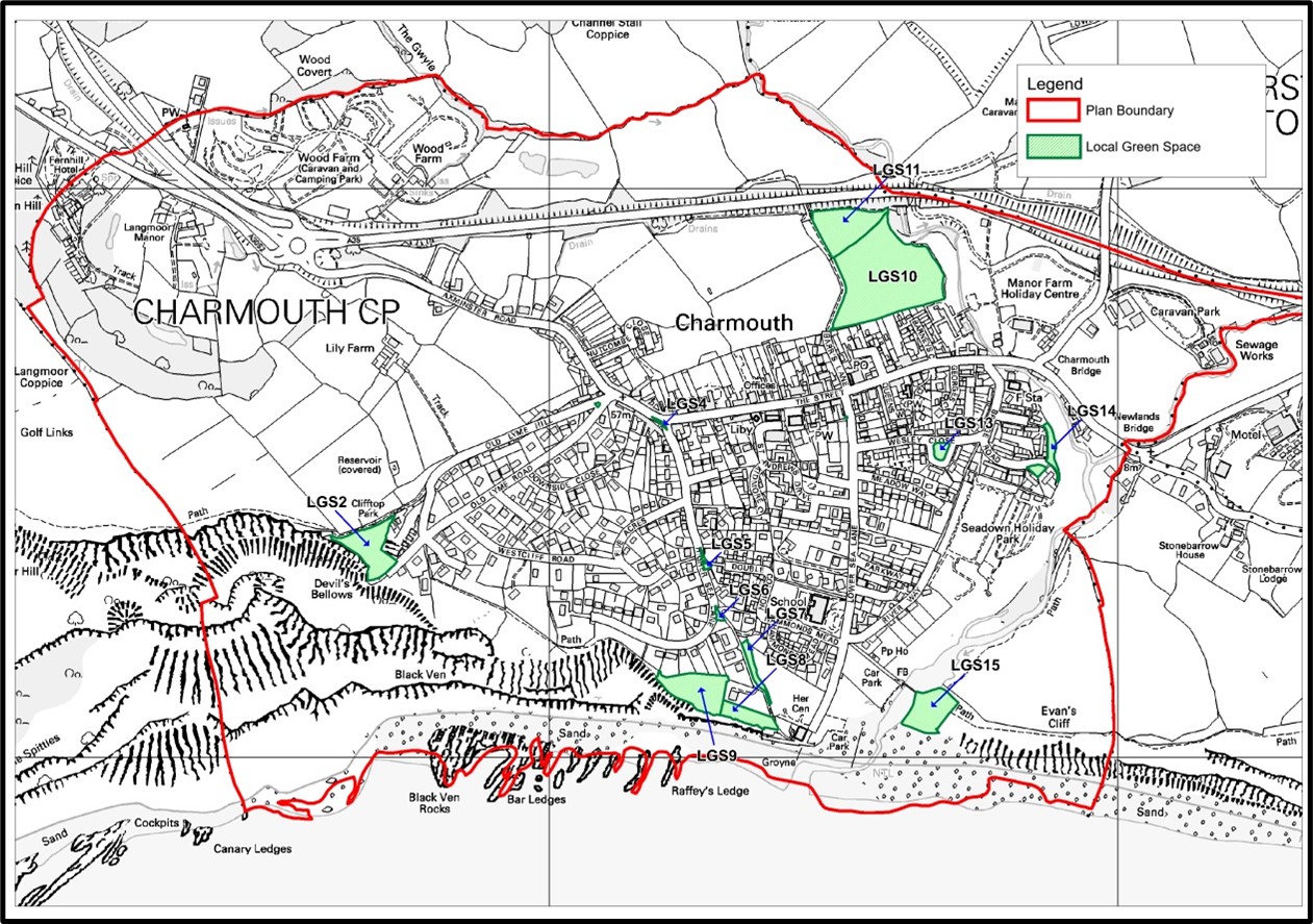
6.66 A comprehensive Report on the proposed Local Green Spaces in Charmouth is available. See link to the Local Green Spaces Report in Appendix E. Table 6.5 provides a summary only, with Map 6.5 showing their locations. A possible Local Green Space, LGS1, was deleted from the proposed Green Spaces following Pre-submission Consultation.
Detailed maps of green spaces are to be found in Appendix H.
6.67. The Green Audit (see link in Appendix E) lists all green areas within the parish, a subset of which are as Local Green Spaces. If identified, it would be possible to add further Local Green Spaces during any review of the CNP.
Table 6.5 Proposed Local Green Spaces
REF |
DESCRIPTION |
REASON FOR IMPORTANCE |
LGS2 |
National Trust field, top of Old Lyme Hill |
Attractive small wild field, with panoramic views of Lyme Bay |
LGS3 |
The Pound, historic site of the old village stocks |
Small area at top of the hill with historical interest, a good view over Charmouth, and a bench. Corner of The Street, Old Lyme Road and Old Lyme Hill. See also Table 4.1 H2 and Table 6.2 View B |
LGS4 |
The Knapp, corner of The Street and Higher Sea Lane |
Small area up the hill with a bench and view down The Street |
LGS5 |
Two small grassy spaces in Higher Sea Lane, either side of the right of way down to Double Common |
Small areas of grass and wild flowers and a bench |
LGS6 |
Area adjoining Higher Sea Lane and the right of way to The Lookout Green. “The Triangle” |
Grass, shrubs. A continuance of the green corridor leading down to the beach |
LGS7 |
A stretch of biodiverse habitat between Higher Sea Lane and The Lookout Green, bordered by the grassed car park and the right of way |
Stretch of wilderness which includes a stream and which supports a diverse range of species for the size of the area. A Species List can be found in the Local Green Spaces Report in Appendix E. |
LGS8 |
The Lookout Green |
Grassy area with benches and picnic tables; panoramic view of the sea. Much used by residents and visitors. |
LGS9 |
Area west of The Lookout Green, bordering Black Ven |
Extension of Lookout Green, rough grass, wilder. Much used by residents and visitors. Home to dozens of ant-hills of the Yellow Meadow Ant. Good grass and scrub for wildlife. |
LGS10 |
Playing Fields |
A large area which extends as far as the river bank, next to the centre of the village, used for recreation, sports and community events. |
LGS11 |
Northern Extension to Playing Fields |
Large mainly grassy area used for sports. |
LGS12 |
Tommy’s Patch, Lower Sea lane |
A small piece of ground, made available by the Parish Council for Remembrance. Community funded. |
LGS13 |
Wesley’s Close Green |
A small play area in the centre of a circle of houses, much used by the children living there |
LGS14 |
Bridge Road Green |
A small play area in the middle of a group of houses, much used by the children living there. |
LGS15 |
Evan’s Cliff |
Green area by beach east of river. Recreation; picnic tables and benches; information display about safety for beach and fossil hunting. |
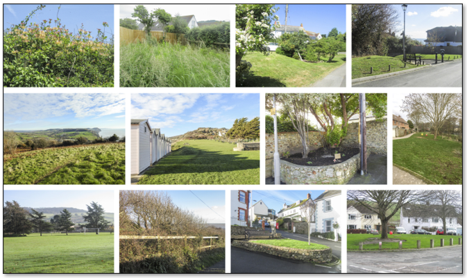
Photos of some of the proposed Local Green Spaces
Map 6.5 Locations of the proposed Local Green Spaces
6.68 In some cases a site needs protection not just from being developed, but also from development in the immediate vicinity which would substantially impact on the enjoyment of that site.
6.69 The VS recognised a high level of interest in the environment and care for green spaces. Without a village green, green spaces in and around the village are part of the village context: such spaces are valuable and valued. Some of the proposed spaces are small and may appear insignificant, but the cumulative effect of these little patches of green helps to preserve the ‘village feel’ that is important to many residents of Charmouth, and which would be diminished if these spaces were tarmacked over. Many of the spaces also include a useful amenity in a village which has a steep hill and a large percentage of elderly residents - a bench. See also 6.22.
At the Open Forum in January 2019 the Steering Group asked attendees for comments on a list of suggested Local Green Spaces. A display of the same Spaces was held in the community library for the following 6 weeks also seeking feedback. See Appendix E for link to Local Green Spaces Report including evidence and comments from the Open Forum and the Library display. Positive comments were made on all spaces proposed during consultation. Many simply agreed with individual spaces proposed, others made statements such as “Maintain green spaces to improve their natural beauty and enjoyment for both residents and visitors”
6.70 Some areas of Local Green Space should also be protected due to their contribution towards a wider green infrastructure network, as outlined in LP-ENV3 and LP-6.3.16. See also 6.42 to 6.50.
6.71 The aim of Policy NE4 is to protect these local green spaces from inappropriate development.
POLICY NE4: Local Green Spaces
|
Lighting
6.72 Most towns and many villages in the UK have a ‘glow’ of light above them, caused by wasted light escaping upwards from street lights, flood lights and other light sources. The Dorset AONB, being largely rural with few towns, suffers from little skyward light pollution away from towns, resulting in largely dark night skies. According to CPRE, current light emissions from Charmouth are in the 1-2 NanoWatts/cm2/sr range which is very low; a range which should be maintained. (www.nightblight.cpre.org.uk/maps)
[sr = steradian, which is a directional quantity, applied in this case to light]
The CPRE Star Count results for 2019 show just how far-reaching the glow from street lights and buildings can be seen. “Light doesn’t respect boundaries, and careless use can see it spread for miles from towns, cities, businesses and motorways, resulting in the loss of one of the countryside’s most magical sights – a dark, starry night sky.” “‘By using well-designed lighting only when and where it is needed, investing in street light dimming schemes and considering part-night lighting – done in consultation with the local community and police – councils have a fantastic opportunity to limit the damage caused by light pollution, reduce carbon emissions and save money.”
6.73 With artificial lighting, there needs to be a balance between there being too much thus causing light pollution, and there being too little causing some people to be concerned for their safety.
6.74 Judging by the VS, responses appear to show that there is a balance. There were 20 comments relating to an excess of light, although these tended to be about specific locations with effects which were localised and personal. 26 respondents were concerned with street lighting inadequacy: some referred to the fact that street lights in much of the village time-out overnight, while others referred to The Street where lighting is on one side only with some concern over safety including tripping (See VS Reports Q8 and Q30).
These apparent anomalies can be corrected, but policy NE5 is intended to maintain the balance that has largely been achieved between safety and light pollution.
Note that crime statistics for Charmouth are very low: during 2019 the police logged 53 incidents, mostly minor, in the Parish. Only 5 respondents (3%) tended to feel the village is not safe.
6.75 Local authorities are advised in paragraph 185 of the NPPF that “By encouraging good design, planning policies and decisions should limit the impact of light pollution from artificial light on local amenity, intrinsically dark landscapes and nature conservation” including effects on wildlife. See also LP-ENV16(iii).
6.76 Therefore while street lighting on existing and new routes will be required for safety, operational and crime prevention reasons, unnecessary light pollution must be prevented through considered and careful design of lights, with the use of downlighting as a primary choice, and lighting times in keeping with the rural character of the area.
POLICY NE5: Street Lighting, and Light Pollution
|
Pollution
6.77 This Plan aims to minimise pollution and its environmental impact, from any source, for the benefit of health and well-being for everyone, whether residents, other locals, or visitors, for now and the future.
6.78 Residents have noted their keenness on green environment and village tranquillity (especially VS Reports Q1 and Q4), and have expressed concern over village pollution sources (VS Report Q8). Within the VS, many comments relate to vehicle pollution specifying fumes, vibration (largely from vehicles going up and down The Street, which is steep), and noise (from The Street and from the A35 bypass).
Planting has mitigated the A35 noise to a certain extent for some of the parish other than when the wind is in the north (see VS Report Q8). Where appropriate, it could be suggested that noise assessment be undertaken if development is near the A35, noting the restrictions within Department for Transport Circular 02/2013, Annex A, paragraph A1.
Beach cleans have been run by CHCC and others for years. Since the VS the Plastic Free Charmouth initiative has been started to free Charmouth of single use plastics.
6.79 As a result of the HRA (see link in Appendix E), it was identified that pollution arising from development within Charmouth should not become a pathway of impact on European Sites (locally, this is Special Area of Conservation). The mitigation for this effect is contained in Policy HRA1: Habitats Regulations which should be read in conjunction with Policy NE6 below.
6.80 This Plan will generally support development which minimises pollution not just during development, but also after the development has been completed. Any development application which ensures future sustainability will be encouraged. Any development must be achieved with the least possible impact on the environment from pollution.
POLICY NE6: Pollution
|
6.81 Charmouth lies almost completely on Lower Jurassic Liassic marine clays (approx. 190 million years old). Upper Greensand (approx. 90 million years old) caps the hills to both east and west of the village. Near the river mouth are signs of a submerged forest dating from approx. 40,000 years ago, where bones of mammoth and red deer as well as the remains of ash and birch tree trunks can be found.
The lias forms hard and soft layers creating water slippages at the surface of hard limestone layers, resulting in instability of the land underpinning Charmouth. Four Slope Instability Zones exist within Charmouth (see Map 6.7)
Map 6.7 Slope Instability Zones
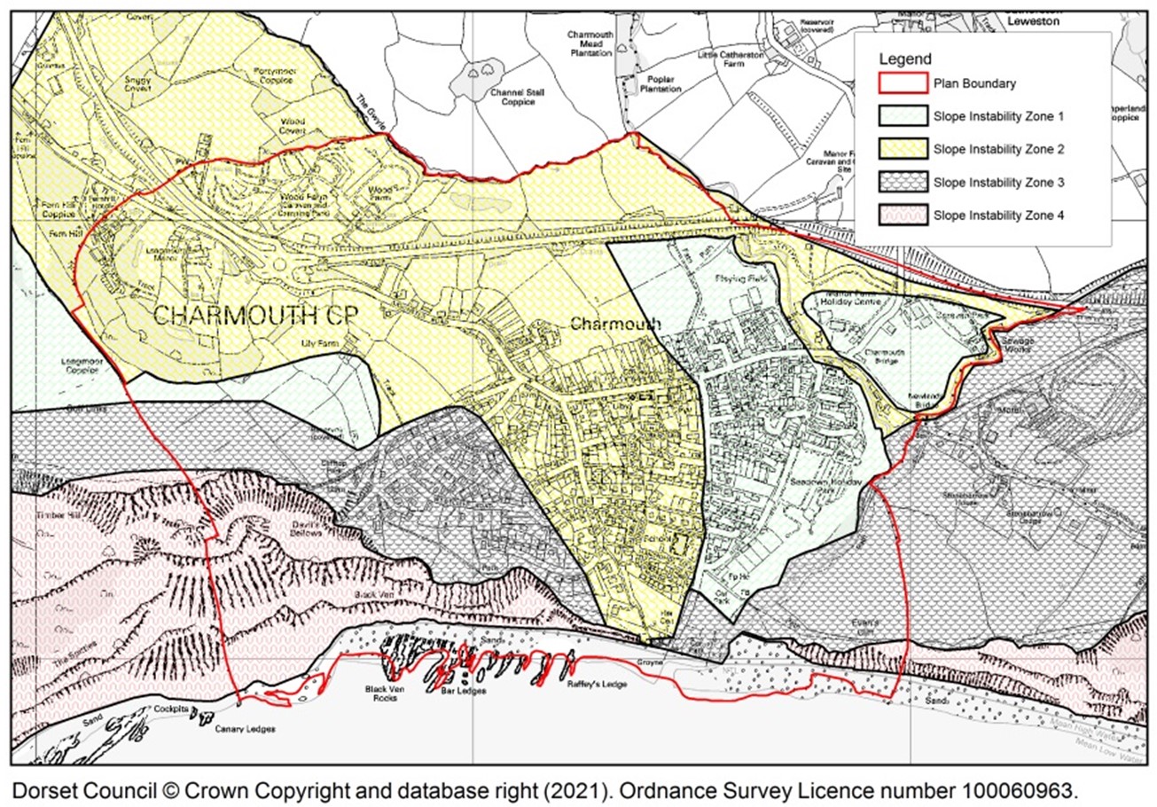
From the map it can be seen that the area with least risk, Zone 1, occupies the lower part of the parish (lower part of the village, playing fields and around Market Field). The majority of the parish, including about half the built area, is within Zone 2. Slope Instability Zone 3 occupies the western part of the village from shore up to upper Old Lyme Hill. Zone 4, the area with the highest instability risk within the parish, has no buildings on it and is largely Black Ven in the west.
6.82 The upper western part of Charmouth has suffered extensive erosion and land slippage over the years: the original very steep trunk road from London to Exeter (Old Lyme Hill, originally the Roman road) was closed in 1824 when the new road to Lyme Regis (Old Lyme Road) was constructed slightly lower down the hill, nearer the sea. Neither road now exists past the very edge of the village. The South West Coast Path which used to link the foreshore area up to Old Lyme Road, and then continue to Lyme Regis along the edge of the golf course from the top of Old Lyme Hill, has eroded down the cliff such that the South West Coast Path westward was closed prior to 2005 and diverted largely via the road. A new route for the South West Coast Path has been developed and will be fully open in 2021, see paragraphs 9.4 to 9.6.
6.83 Dorset Council provides information on what is required for planning applications in the areas of potential instability and explains requirements for the various zones within those areas. It also describes what type of development is appropriate in the areas of greatest risk.
6.84 Risks arise from the inherent instability created by the local geology, as well as those areas of future land instability and potential new flood areas resulting from the failure or removal of the Charmouth coast defences some time after 2025. See Chapter 10 on Coastal Change.
6.85 The design and construction of any new development in Charmouth where slope instability is a risk should take risk into account by ensuring that temporary or long term changes in loading on slopes are not excessive in terms of the potential instability. Advice of engineers or geotechnical specialists, who fully understand the local geology and nature of the slopes, will be required. It is important that proposals for development do not trigger ground movements either within or beyond a development site.
Furthermore, the design and construction of new developments should include drainage that does not result in surface water entering the ground. All surface water drainage shall be taken to an adequate piped, or otherwise sealed, drainage system. This includes new car parking areas: the use of permeable surfaces for car parking areas is not appropriate in areas of potential slope instability. All opportunities should be taken to check the condition of and improve any existing drainage systems. Recommendations from a suitably qualified expert to address such instability issues are likely to be required.
6.86 Buildings must therefore be designed and built to address Charmouth’s land instability and drainage risks e.g. with enhanced foundations and having no soakaways etc., and avoid any negative impacts on the area’s overall drainage network.
POLICY NE7: Land Instability and Geology
|
< Previous | ^ Top | Next >