This Glossary defines terms shown in italics in the Plan’s policies and where the word/phrase first appears in each Chapter (see para 2.9)
Terms in bold in the text of the Glossary are defined elsewhere in the Glossary.
Affordable Housing/Homes: Housing for sale or rent, for those whose needs are not met by the market (including housing that provides a subsidised route to home ownership and/or is for essential local workers); and which complies with one or more of the following definitions:
a) Affordable housing for rent: meets all of the following conditions: (a) the rent is set in accordance with the Government’s rent policy, or is at least 20% below local market rents; (b) the landlord is a registered provider, except where it is included as part of a Build to Rent scheme; and (c) it includes provisions to remain at an affordable price for future eligible households, or for the subsidy to be recycled for alternative affordable housing provision. For Build to Rent schemes affordable housing for rent is expected to be the normal form of affordable housing provision (and, in this context, is known as Affordable Private Rent).
b) Starter homes: is as specified in Sections 2 and 3 of the Housing and Planning Act 2016 and any secondary legislation made under these sections. Income restrictions should be used to limit a household’s eligibility to purchase a starter home to those who have maximum household incomes of £80,000 a year or less. (see also Starter/First Homes)
c) Discounted market sales housing: is that sold at a discount of at least 20% below local market value. Eligibility is determined with regard to local incomes and local house prices. Provisions should be in place to ensure housing remains at a discount for future eligible households.
d) Other affordable routes to home ownership: is housing provided for sale that provides a route to ownership for those who could not achieve home ownership through the market. It includes shared ownership, relevant equity loans, and other low cost homes for sale and rent to buy (which includes a period of intermediate rent). Where public grant funding is provided, there should be provisions for the homes to remain at an affordable price for future eligible households, or for any receipts to be recycled for alternative affordable housing provision, or refunded to Government or the relevant authority specified in the funding agreement.
Adjoining: Sites adjoining the Defined Development Boundary must abut that Boundary or the far edge of a road that runs alongside that Boundary. (see Rounding Off).
Area of Outstanding Natural Beauty (AONB): An area of countryside which has been designated for conservation due to its significant landscape value and scenic beauty of national importance. Charmouth is situated in the Dorset AONB.
Basic Conditions: Criteria that a Neighbourhood Plan must meet before it can come into force. These are:
Biodiversity: The variety and variability of life on Earth: the variability among living organisms, including plants, birds, insects and all other animals; mosses, lichens, algae, bacteria, viruses etc; within terrestrial, marine, and other aquatic ecosystems; and the ecological complexes of which they are part. This includes diversity within species, between species, and of ecosystems.
Biodiversity Mitigation and Enhancement Plan: An ecological survey carried out by a suitably qualified person prior to applying for planning permission. This applies to all development sites of 0.1ha or greater in size or where there are known protected species or important habitats/habitat features. More specifically, a BMEP is required for a greenfield or brownfield site greater than 0.1ha, which isn't already being used as a residential or business premises. A BMEP covers habitat as well as protected species matters.
Brownfield: Land that has been previously developed and is, or was, occupied by a permanent structure and any associated fixed surface infrastructure (excludes gardens).
Building for Life: A Government-endorsed industry standard for well-designed homes and neighbourhoods. It provides questions designed to help structure discussions between local communities, local planning authorities, developers and other stakeholders along with a traffic light scoring system and associated quality mark.
Building Line: The line formed by the principal (normally front, road facing) elevation of the Original Building to which new developments should be aligned and not normally encroach beyond.
Charmouth Connection: To be used in legal agreements to determine how Affordable Housing should be allocated:
Charmouth Connection is a person who satisfies the local connection criteria of the Dorset Housing Allocations Policy 2021 - 2026.
The criteria shall be applied firstly to those with a connection to the parish of Charmouth. The local connection may be extended to the adjoining rural parishes which Charmouth serves as a community service centre if there are no people with a connection to Charmouth Parish, and then to the rest of the Dorset Council area.
Charmouth Housing Needs Statement: A summary of Charmouth’s housing needs by size, type, tenure and originally based on the 2018 Housing Needs Assessment (HNA). This will be updated over time as necessary and be available on the Charmouth Parish Council website to inform developers of the number and type of housing required at that time.
Charmouth Traders: A local working group who represent shop owners and local businesses within Charmouth.
Coastal Change Management Area (CCMA): An area likely to be affected by coastal change (physical change to the shoreline through erosion, coastal landslip, permanent inundation or coastal accretion). Councils decide whether an area of coast should be a CCMA and therefore whether it is suitable for development, and of what type.
Coastal Defences: A key part of coastal management, in which the land-sea boundary is protected from erosion and flooding.
Community Assets and Amenities: Recognised as important by virtue of their contribution to the character of the village, its social fabric and cohesion, and the amenity, enjoyment and security of the residents. Included in Community Facilities.
Community Facilities: Includes all shops, pubs, eating places, medical practice, educational bodies, recreational park area, community/village/youth club halls, library, church, clubs etc. which together form the functioning village of Charmouth. This includes Community Assets and Amenities.
Conservation:(i) The process of maintaining and managing change to a heritage asset in a way that sustains and, where appropriate, enhances its significance. (ii) The protection of plants, animals, and natural areas; protection and management of the environment and natural resources.
Conservation Area: The Charmouth part (designated 1972) of the Charmouth and Chideock Conservation Area which are areas of special architectural or historic interest where policies exist for the protection and enhancement of these areas.
Countryside: Open land outside the Defined Development Boundary where development is generally restricted.
Defined Development Boundary: An existing boundary incorporated in the Local Plan which defines the extent of the built-up settlement area of Charmouth and, within this boundary, there is a general presumption in favour of development and outside this boundary, development is generally restricted.
Design and Access Statement: A report accompanying a planning application explaining how a proposed development responds to its site and setting and how it will be accessed. In Charmouth, as a Designated Area, a Report is required for one or more houses or buildings of 100 sq. m. or more.
Design Guide: A document approved by an appropriate body which promotes the design and style of homes and neighbourhoods local people want to see and their views are represented in this Neighbourhood Plan.
Designated Area: Charmouth is a ‘designated area’ due to its status as an AONB and World Heritage Site, and having SSSIs, a Conservation Area where special planning policy protections exist e.g. certain national Permitted Development Rights do not apply.
Designated Heritage Asset: See Heritage Asset.
Development Plan: Defined in section 38 of the Planning and Compulsory Purchase Act 2004 to include the adopted Local Plan and ‘made’ neighbourhood development plans.
Distinctive Local Features: Attractive architectural features visible near to the development plot which should be reflected in the design of new buildings. These are features visible when looking out from the plot, those visible on neighbouring properties when looking at the plot from the street or other public access point as well as traditional features appearing in the wider Charmouth/Dorset area. In the case of extensions/replacements this includes distinctive features of any remaining parts of the former buildings.
Dorset’s Local Enterprise Partnership (LEP): an organisation that works in partnership with businesses, local government, education institutes and other industry and community organisations to drive economic growth, attract funding and investment, increase productivity and develop local industrial strategies for Dorset. Their priorities are to:-
Dorset Notable: Wildlife species chosen in Dorset as indicators of good unimproved or semi-improved habitat to assist in the selection of Sites of Nature Conservation Interest. Such species are not classified as Rare, but are Scarce.
Ecological Network: The interconnection of habitats and ecosystems allowing for persistence of species within sites as well as movement across the landscape between sites.
England Coast Path: The proposed long-distance National Trail which will follow the coastline of England which, when complete, will be 2,795 miles (4,500 kilometres) in length. It is due to be completed in 2021 and proposed plans would move the existing diverted South West Coast Path off the road both east and west of Charmouth.
Environmental Impact Assessment: A procedure to be followed for certain types of project to ensure that decisions are made in full knowledge of any likely significant effects on the environment.
European and international wildlife sites: See International, EU, National and Local Designated Sites of Importance for Biodiversity.
Evidence Base: The information and data gathered by the Neighbourhood Steering Group to inform and support the policies set out in the Neighbourhood Plan.
First Homes: (see also Starter/First Homes) Homes for sale at a discount for eligible first-time buyers with priority to those with a Charmouth Connection.
Flood Risk: The combination of probability of a particular flood event and its corresponding hazard, is used to refer to the scale of flood effect, combining hazard and probability, upon a particular site.
Geodiversity: The range of rocks, minerals, fossils, soils and landforms.
Green Corridor: Generally a stretch of land that provides sufficient habitat to support wildlife, while allowing the movement of wildlife along it. Species may be corridor dwellers or may be passage users. Corridors can provide a habitat for many diverse species, acting both as a stepping stone and a link between other green areas. Common green corridors include river banks, hedges, roadside grass verges and railway embankments. Also known as Wildlife Corridors or Habitat Corridors.
Green Infrastructure: A network of multi-functional green space, urban and rural, which is capable of delivering a wide range of environmental and quality of life benefits for local communities.
Habitat: The place in which a species of animal or plant lives, providing a particular set of environmental conditions. Often used in a wider sense, referring to major assemblages or communities of plants and animals found together.
Habitats Regulation Assessment: Tests the impacts of a plan or project on nature conservation sites of European importance and is required under EU legislation.
Heritage Asset: A building, monument, site, place, area or landscape identified as having a degree of significance meriting consideration in planning decisions, because of its heritage interest. They are likely to hold evidence of the substance and evolution of places, and of the people and cultures that made them. Features of a heritage asset include those which contribute to its special historical, archaeological, social, artistic or architectural interest. Can be Designated or Non-Designated. Designated Heritage Assets: where special protections exist such as World Heritage Sites, Scheduled Monuments, Listed Buildings, Protected Wreck Sites, Registered Park and Gardens, Registered Battlefield and Conservation Areas designated under the relevant legislation. Non-Designated Heritage Assets: buildings, monuments, sites, places, areas or landscapes identified by plan-making bodies as having a degree of heritage significance meriting consideration in planning decisions but which do not meet the criteria for Designated Heritage Assets.
Heritage Coast: A strip of coastline in England and Wales, the extent of which is defined by agreement between the relevant statutory national agency (Natural England) and the relevant local authority. Such areas are recognised for their natural beauty, wildlife and heritage and amongst the purposes of definition is support for these qualities and enabling enjoyment of them by the public. Charmouth is within the Dorset Heritage Coast. A Heritage Coast is a separate definition from World Heritage Coast.
Holiday Lets: A property which has a planning condition imposed restricting its use at specified times of the year to its use as a holiday let i.e. the property cannot be used as a permanent dwelling.
Housing Needs: Charmouth’s priority needs for specific sizes, types and tenures of housing as detailed in Chapter 8 of the Charmouth Neighbourhood Plan and summarised in the Charmouth Housing Needs Statement.
Housing Needs Assessment (HNA): Undertaken by independent consultants AECOM Ltd and published in March 2018. This is a demand-led study of the amount and type of housing that Charmouth might need but takes no account of Charmouth’s constraints to development (see also Charmouth Housing Needs Statement which provides the latest guidance on Housing Needs).
Immediate Locality: The area spreading out from a plot for housing development which has a similar pattern of development, plot sizes, overall density and comparable building forms. The new development should reflect the prevailing settlement pattern (plot size, spacing between buildings, orientation and shape) and density of development.
Infill: New development e.g. housing between, or to the rear, of existing buildings.
Intermediate Affordable Homes: See Affordable Housing definition section d) and includes ‘shared ownership’ which offers the occupant part ownership/part affordable rent of a home e.g. from a Housing Association.
International, EU, National and Local Designated Sites of Importance for Biodiversity:
Instability Zones: The parish area includes four levels of slope instability ranging from Zone 1 (unlikely that problems will arise from slope instability) to Zone 4 (areas in which there may be severe problems arising from coastal erosion and/or landslipping.
Jurassic Coast: A popular name for the Dorset and East Devon World Heritage Site (see World Heritage Site).
Landscape and Visual Impact Assessment: The technique used to assess the effects of change on the landscape and can be key to effective planning decisions.
Listed Building: A building, object or structure that has been judged to be of national importance in terms of architectural or historic interest and included on a special register, called the List of Buildings of Special Architectural or Historic Interest.
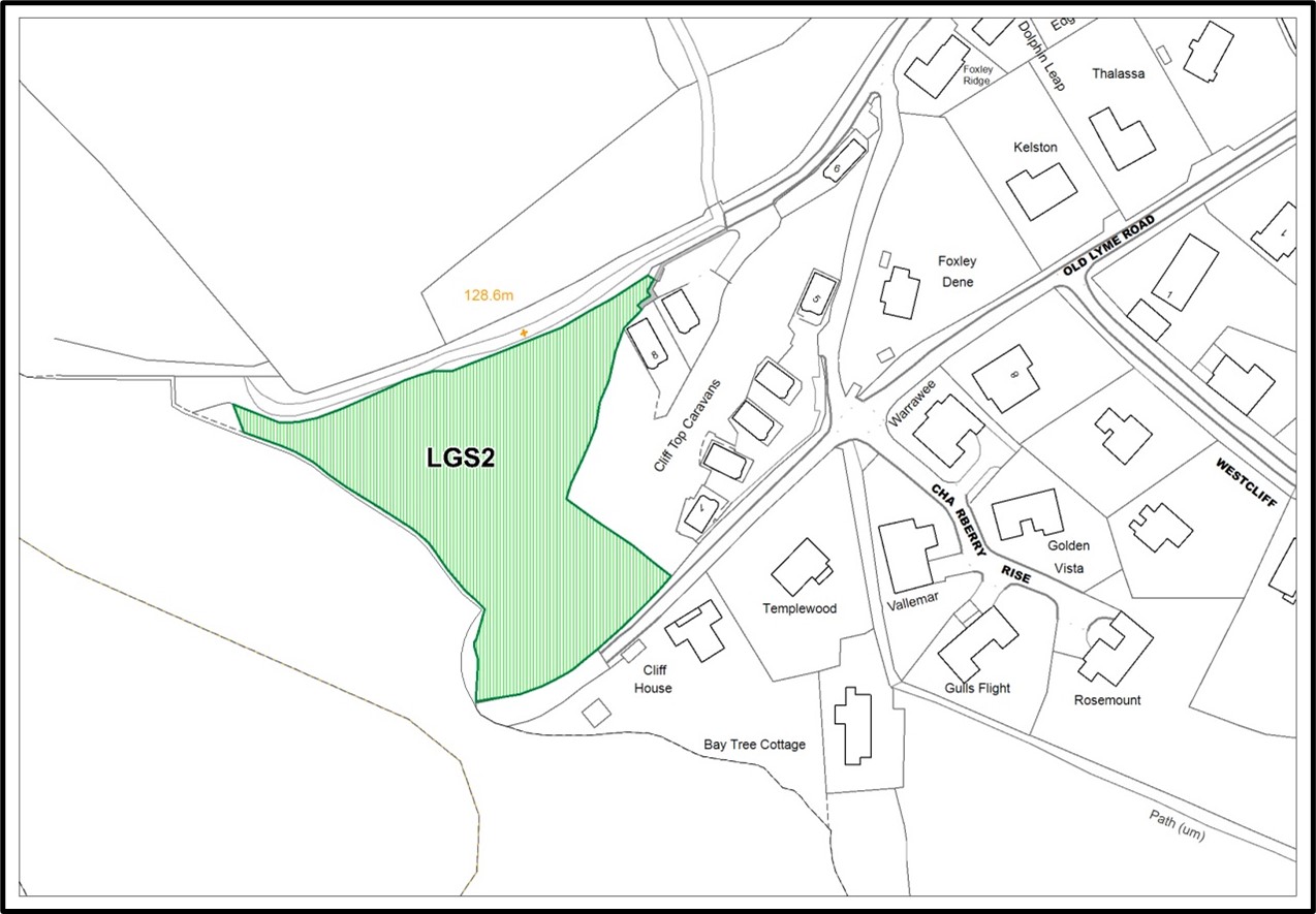
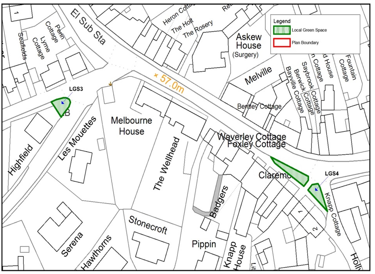
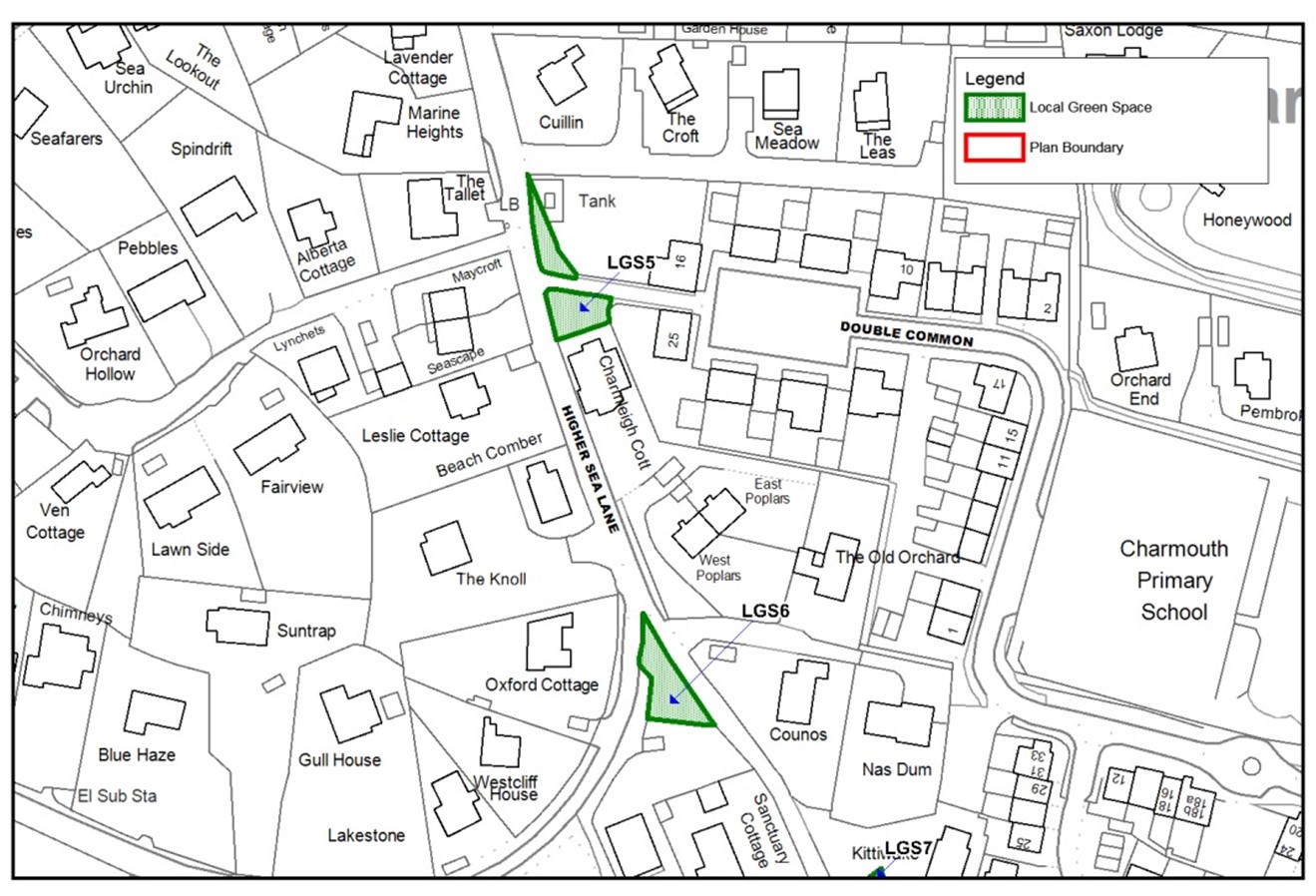
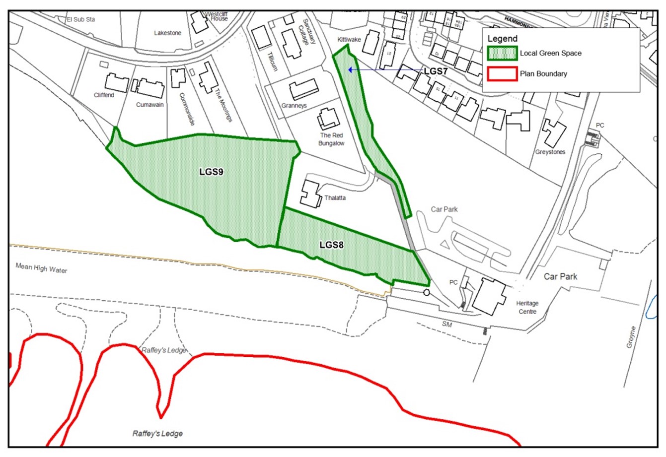
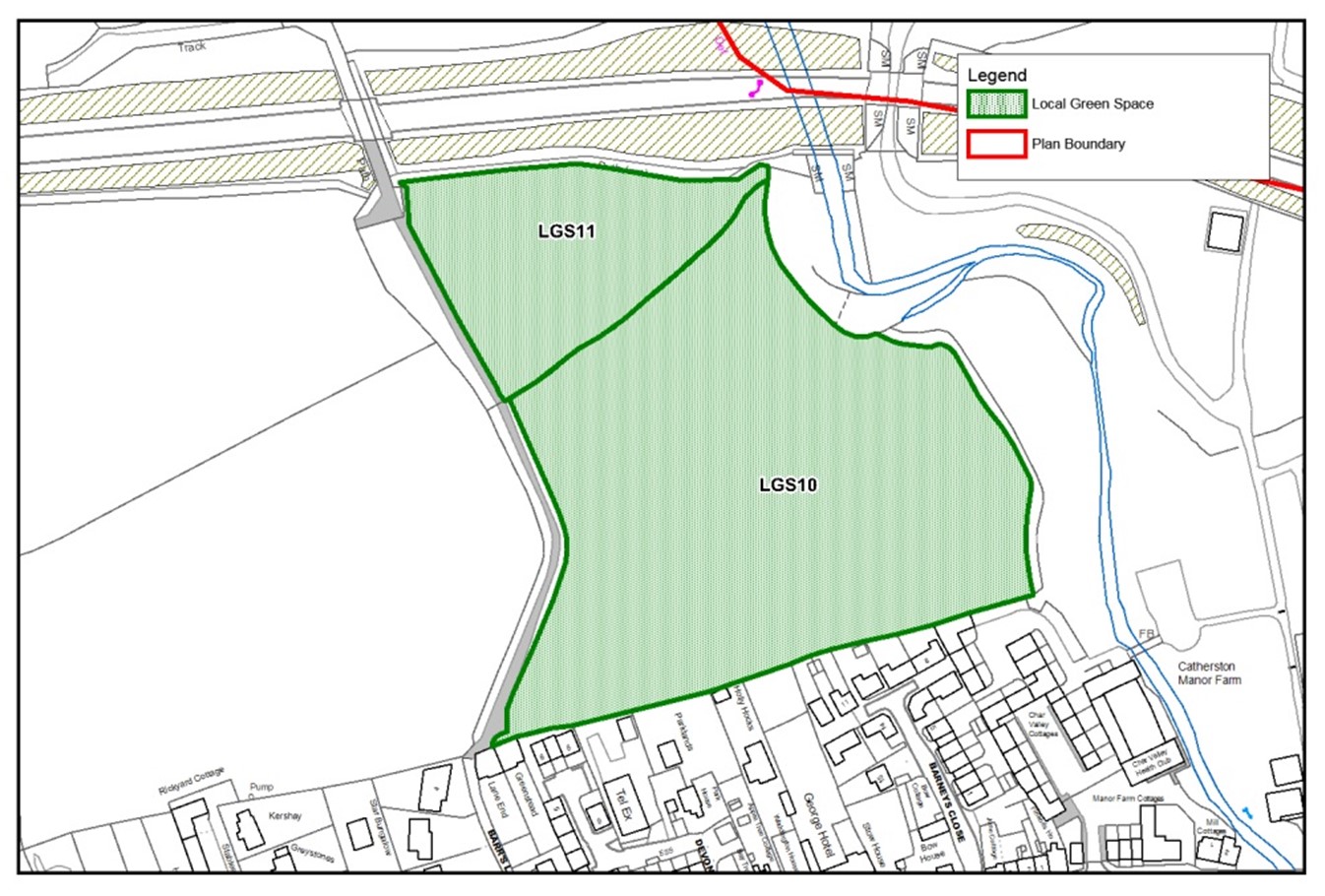
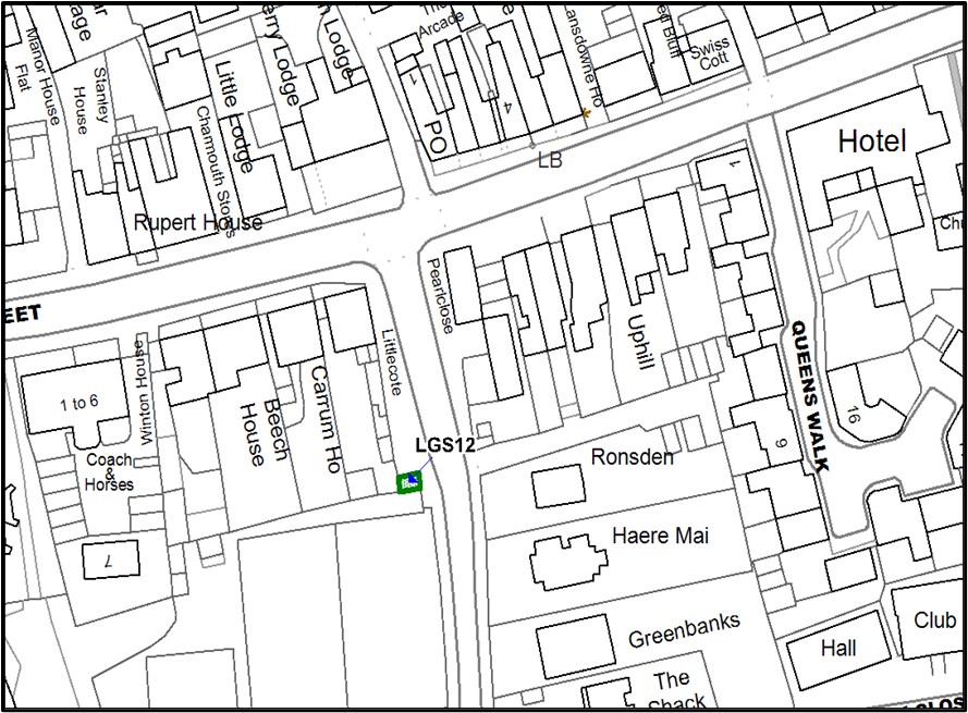
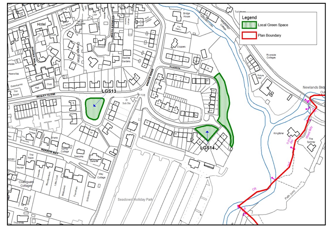
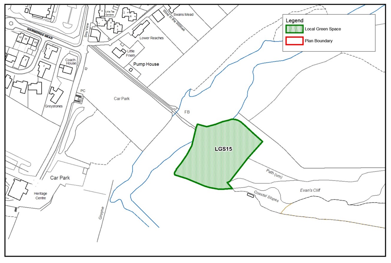
Local Green Spaces: Local Green Space designation protects green areas or open spaces against development where they are of particular importance to local communities.
Local Plan: The plan for the future development of the local area, drawn up by the local planning authority in consultation with the community. The Local Plan covering Charmouth is the 2015 West Dorset, Weymouth & Portland Local Plan or its successor and is currently under review as part of a new Dorset-wide Local Plan.
Local Planning Authority: The public authority whose duty it is to carry out specific planning functions for a particular area including determining planning applications. For Charmouth, since 1 April 2019 this is Dorset Council (previously West Dorset District Council).
Made: When the neighbourhood plan is approved and adopted as part of the area’s Development Plan alongside the Local Plan.
Market Housing: Homes available for sale on the open market i.e. not Affordable Homes.
National Planning Policy Framework (2021): Sets out the Government’s planning policies for England and how these are expected to be applied.
National Design Guide: Issued by Government in 2019, the guide sets out 10 characteristics of well-designed places and demonstrates what good design means in practice.
Neighbourhood Area: This is the designated area that a Neighbourhood Plan covers and for Charmouth this is the area within the Parish boundary.
Neighbourhood Plan/ Neighbourhood Development Plan: A neighbourhood plan is a document that sets out planning policies for a local area. It is used to decide whether to approve planning applications. It is written by the local community to ensure the area gets the right types of development, in the right place but protects the natural environment. Charmouth’s Plan sits alongside Dorset Council’s Local Plan and provides more detail on specific areas or issues within Charmouth’s parish boundary.
Non-Designated Heritage Asset: See Heritage Asset
Open Space: All open space of public value, including not just land, but also areas of water (such as rivers, canals, lakes and reservoirs) which offer important opportunities for sport and recreation and can act as a visual amenity.
Open Forum(s): Presentations and ‘open’ meetings with residents and local businesses concerning various stages of the Neighbourhood Plan.
Original Building: A building as it existed on 1 July 1948 or, if constructed after 1 July 1948, as it was built originally.
Parish: The land area which forms the Parish of Charmouth.
Parish Council: Charmouth Parish Council.
Permitted Development Rights: Rights to undertake certain small types of Development without the need to apply for planning permission. In Charmouth, as a Designated Area, these Rights are more limited than exist nationally.
Plan Area: The designated area of the Charmouth Neighbourhood Plan which is identical to the Charmouth Parish area.
Plan Period: The timespan of the Charmouth Neighbourhood Plan from 2020 to 2035 (15 years inclusive).
Playing Field: The whole of a site which encompasses at least one playing pitch as defined in the Town and Country Planning (Development Management Procedure) (England) Order 2015. In Charmouth this is also known as the Recreation Ground.
Policies: Polices of the Charmouth Neighbourhood Plan which, together with Local Plan policies, will be a material consideration when planning applications are determined by Dorset Council.
Pollution: Anything that affects the quality of land, air, water or soils, which might lead to an adverse impact on human health, the natural environment or general amenity. Pollution can arise from a range of emissions, including smoke, fumes, gases, dust, steam, odour, noise and light.
Principal Residency: The sole or main residence of the occupier for the majority of their time and cannot be used as a Second Home or Holiday Let.
Protected Species: Species specially protected by the law, primarily under Schedules 1 (birds), 5 (amphibians, reptiles & mammals), and 8 (plants) of the Wildlife and Countryside Act 1981.
Referendum: A vote by the eligible voters of a Neighbourhood Plan area. Neighbourhood Plans are “made” when a referendum produces a majority vote in their favour.
Retail Hub: The area where existing commercial/retail properties are concentrated within the centre of the village.
Rounding-off: To avoid marked intrusion into the open countryside, sites should adjoin the existing Defined Development Boundary and provide a symmetry or completion to this Boundary. Rounding off development should not visually extend development into the open countryside and should be predominantly enclosed by edging features such as existing physical and logical boundaries. The presence of definite boundaries, landscape features, the history and nature of the land, the form of existing development and topography will be important considerations.
Rural Exception Sites: Small sites adjoining the Defined Development Boundary (see also Adjoining and Rounding-off) used for Affordable Housing in perpetuity where sites would not normally be used for housing. Rural Exception Sites seek to address the housing needs of the local community that the market is failing to provide by accommodating households who are either current residents or have an existing family or employment connection (see Charmouth Connection).
Social/Affordable Rent: see Affordable Housing.
Second Home: Privately-owned habitable accommodation that is not occupied by anyone as their main residence. It may be occupied occasionally, for example as a holiday home or when working away from the household’s main home.
Service Provider Questionnaire: A Questionnaire given to Service Providers in Charmouth, including retail outlets, tradesmen, businesses, leisure services, the school and community facilities. 31 responses were compiled and results contained in a Service Provider Survey Report.
Setting: The surroundings of a asset that make a positive (or negative) contribution to its significance, or, may affect the ability to appreciate that significance. The extent of the setting may change over time.
Shoreline Management Plan: A non-statutory council plan providing a large-scale assessment of the risk to people and to the developed, historic and natural environment associated with coastal processes and determines the action which will be taken to protect the area, or not.
Significance: The importance or value of an asset to this and future generations because of its special interest. That interest may, for example, be archaeological, architectural, artistic, economic, environmental, historic or social.
Site of Nature Conservation Interest (SNCI): Sites selected for their habitat or species interest. In Dorset these sites are selected by an SNCI Panel with representatives of Dorset Wildlife Trust, Dorset Environmental Records Centre, Natural England and Dorset County Council.
Site of Special Scientific Interest (SSSI): Sites designated by Natural England under the Wildlife and Countryside Act 1981 and are protected areas designated as being of special interest by virtue of its flora, fauna, geological or geomorphological features. SSSIs collectively form a nationally important series of sites of biological or geological value.
Small Homes/Houses: Homes with 1-3 bedrooms.
South West Coast Path (SWCP): Britain’s longest path stretching from Minehead to Poole Harbour. The village is on the South West Coast Path and what will become the England Coast Path (opening 2020).
Special Area of Conservation: Sites exist under EC Council Directive on the Conservation of Natural Habitats and of Wild Fauna and Flora, 1992 (The Habitats Directive). Sites of international importance, designated to conserve habitats and species which are rare or threatened within the European Union. Sites hosting habitats or species which are particularly threatened have "priority" status.
Starter/First Homes: see Affordable Housing definition section b) and First Homes.
Steering Group: the Charmouth residents/ volunteers who undertook the evidence gathering, community consultations and drafting of the Charmouth Neighbourhood Plan and its policies.
Strategic Environmental Assessment: A procedure (set out in the Environmental Assessment of Plans and Programmes Regulations 2004) which requires the formal environmental assessment of certain plans and programmes which are likely to have significant effects on the environment.
Strategic Housing Land Availability Assessment (SHLAA): A technical exercise undertaken by Dorset Council to determine the quantity and suitability of land potentially available for housing development following a call for sites from landowners, agents and developers. At the time of drafting the Charmouth Neighbourhood Plan, this was the 2018 Dorset SHLAA, updated in September 2020, which did not identify any suitable sites in Charmouth.
Supplementary Planning Guidance: Documents which add further detail to the policies in the Local Plan. They can be used to provide further guidance for development on specific sites, or on particular issues such as design and are capable of being a material consideration in planning decisions. Charmouth is covered by the 2009 West Dorset Design & Sustainable Development Planning Guidelines which provides 10 design policies.
Sustainable Development: Development which meets the needs of the present without compromising the ability of future generations to meet their own needs. It is about supporting growth and innovation for jobs and prosperity, creating a high y built environment with accessible local services and the home to meet current and future needs, whilst protecting and enhancing our environment, using natural resources wisely and minimizing waste and pollution.
Sustainable Development Goals: The Sustainable Development Goals developed by the United Nations are the blueprint to achieve a better and more sustainable future for all. They address global challenges including those related to poverty, inequality, climate, environmental degradation, prosperity, and peace and justice.
Tree Preservation Order (TPO): A Tree Preservation Order is an order made by a local planning authority in England to protect specific trees, groups of trees or woodlands in the interests of amenity.
Use Class: The Town and Country Planning (Use Classes) Order 1987 (as amended) puts uses of land and buildings into various categories known as 'Use Classes'. In many cases involving similar types of use, a change of use of a building or land does not need planning permission. Planning permission is not needed when both the present and proposed uses fall within the same ‘class’, or if the Town and Country Planning (Use Classes) Order says that a change of class is permitted to another specified class. Sui Generis means uses that do not fall within any use class.
Viability Assessment: An ‘open book’ assessment submitted with a planning application and available for public scrutiny, which demonstrates the financial viability justification for the mix of housing including any Market Homes on a Rural Exception Site. This applies both at the time of the original planning application and any subsequent revisions.
Village Improvement Projects: Projects identified during public consultations on the Neighbourhood Plan identified as being beneficial to the enjoyment of the community.
Village Survey: A comprehensive Village Survey with 854 being issued to all residents and businesses within Charmouth in February 2017 resulting in 255 returns. The Survey comprised of 7 sections and sought views on: the draft vision, natural environment, tourism, transport, community facilities, housing and employment in the parish. There were 38 questions in total and 29 reports were compiled collating the responses.
Wildlife Corridor: See Green Corridor.
World Heritage Coast: The term used to include both the Dorset and East Devon Coast World Heritage Site, and the immediate towns and countryside which provide the education, accommodation and transport facilities that enable people to visit and understand the World Heritage Site. The site was designated because it provides a unique example of 185 million years of Earth's history, recording life, significant ongoing geological processes in the development of landforms, and significant geomorphic or physiographic features. See Jurassic Coast.
World Heritage Site: An area considered to be of outstanding universal value, that meets one or more of the four criteria set out by the United Nations Educational, Scientific and Cultural Organisation (UNESCO).
| Abbreviation | Meaning |
|---|---|
| AONB | Area of Outstanding Natural Beauty |
| AONB MP | Dorset AONB Management Plan 2019-2024 |
| BET | Business, Economy and Tourism |
| BMEP | Biodiversity Mitigation and Enhancement Plan |
| CCSCAA | Charmouth, Chideock and Seatown Conservation Area Appraisal |
| CHCC | Charmouth Heritage Coast Centre |
| CLT | Community Land Trust |
| CNP or NP | Charmouth Neighbourhood Plan |
| CPC | Charmouth Parish Council |
| CPRE | Council for the Preservation of Rural England |
| DC | Dorset Council |
| DDB | Charmouth’s Defined Development Boundary |
| DERC | Dorset Environmental Records Centre |
| DFY | DorsetForYou website |
| DHTS | Dorset Historic Towns Survey 2011 |
| ECP | England Coast Path |
| HNA | Charmouth Neighbourhood Plan Housing Needs Assessment 2018 |
| HRA | Habitats Regulations Assessments |
| IT | Information Technology |
| LEP | Dorset Local Enterprise Partnership |
| LP | West Dorset, Weymouth & Portland Local Plan 2015 |
| LP-ENVn | Local Plan policy number |
| LP-n.n.n | Local Plan section number |
| LVIA | Landscape and Visual Impact Assessment |
| NPPF | National Planning Policy Framework 2021 |
| NPPG | National Planning Practice Guidance |
| OS | Ordnance Survey relating to maps |
| SAC | Special Area of Conservation |
| SDADCAG | South Devon and Dorset Coastal Advisory Group (responsible for developing SMP2 = current Shoreline Management Plan) |
| SEA | Strategic Environmental Assessment |
| SEP | Dorset’s Strategic Economic Plan |
| SHLAA | Strategic Housing Land Availability Assessment |
| SMP | Shoreline Management Plan |
| SNCI | Site of National Conservation Interest |
| SSSI | Site of Special Scientific Interest |
| SWCP | South West Coast Path |
| UNESCO | United Nations Educational, Scientific and Cultural Organization |
| VS | Village Survey for Charmouth Neighbourhood Plan (contains both quantitative and qualitative responses and analyses) |
| WHS | World Heritage Site (Jurassic Coast) |
| Document | Link |
|---|---|
AONB MP = Dorset AONB Management Plan 2019-2024 |
https://www.dorsetaonb.org.uk/wp-content/uploads/2019/04/DAONB_Managmentplan.pdf |
Basic Conditions Statement(Draft) |
|
‘Biodiversity 2020: A Strategy for England’s wildlife and ecosystem services’ DEFRA, published 2011 |
|
BMEP |
|
Building for Life |
|
CCSCAA = Charmouth Chideock Seatown Conservation Area Appraisal |
|
2011 Census, Local Area Report for Charmouth Parish |
https://www.nomisweb.co.uk/reports/localarea?compare=E04003520 |
Charmouth Foreshore Management Plan: Charmouth Parish Council |
|
Charmouth Housing Needs Statement |
|
Charmouth Neighbourhood Plan Examination Report |
https://www.charmouthparishcouncil.gov.uk/file/charmouth-np-examiner-report-281021-2.pdf |
Climate Change Mitigation Position Paper: A Dorset Local Nature Partnership Position Paper |
https://dorsetlnp.org.uk/wp-content/uploads/2019/01/Climate-Change-Mitigation-Position-Paper2.pdf |
CPRE (light emissions analysis) |
link only for levels of light at night www.nightblight.cpre.org.uk/maps |
Dorset Biodiversity Appraisal Framework (includes Compensation Framework in Guidance Section C) |
|
DERC (Dorset Environmental Records Centre) |
|
DFY = DorsetForYou website |
|
DHTS = Dorset Historic Towns Survey 2011, for Charmouth |
|
Dorset Coastal Forum: Strategy 2011-2021 |
https://www.dorsetcoast.com/wp-content/uploads/2017/09/Dorset_Coast_Strategy_finallow_res.pdf |
Dorset’s Environmental Economy 2015 |
|
Dorset Land and Seascape Character Assessment |
http://www.cscope.eu/_files/MSP_Dorset/Land-and_Seascape_Character_Assessment.pdf |
Dorset Local Enterprise Plan/ Dorset Strategic Economic Plan |
|
Ecological Networks |
|
Green Spaces Report |
|
Habitats Regulation Assessment Report |
|
House of Commons Environment, Food and Rural Affairs Committee : Coastal flooding and erosion, and adaptation to climate change: Interim Report’ November 2019 |
https://publications.parliament.uk/pa/cm201919/cmselect/cmenvfru/56/56.pdf |
Housing Needs Assessment |
|
Jurassic Coast Trust Partnership Plan 2020-2025 |
https://jurassiccoast.org/wp-content/uploads/2020/09/Juassic-Coast-Partnership-Plan-2020-2025.pdf OR Jurassic-Coast-Partnership-Plan-2020-2025.pdf |
Localism Act 2011 |
http://www.legislation.gov.uk/ukpga/2011/20/contents/enacted |
Locality doct |
https://locality.org.uk/services-tools/neighbourhood-planning/ |
LP = Local Plan 2015 |
|
LP 2021 Preferred Options Consultation |
|
Non-Designated Heritage Assets Assessment |
https://historicengland.org.uk/advice/hpg/has/locallylistedhas/ https://www.gov.uk/guidance/conserving-and-enhancing-the-historic-environment#non-designated |
NPPF 2021 |
|
ONS Labour Force Survey |
|
Open Forums Events & Feedback |
|
Pathfinder Project Report, Jurassic Coast section |
https://jurassiccoast.org/wp-content/uploads/2011/09/jurassic_coast_pathfinder_project-_final_report_to_defra.pdf OR Microsoft Word - Document1 (jurassiccoast.org) |
Permitted Development Rights |
|
Strategic Environment Assessment Report |
|
The Royal Society sea level rise |
https://royalsociety.org/topics-policy/projects/climate-change-evidence-causes/question-14/ |
Service Provider Questionnaire & Report |
|
Strategic Housing Land Availability Assessment, 2018 (SHLAA) |
|
Supplementary Planning Guidance: Design and Sustainable Development Planning Guidelines, 2009 |
|
SMP2 = Shoreline Management Plan 2 (2011) (West Dorset area) |
|
SMP2 (complete) |
|
UK Committee on Climate Change report on housing |
https://www.theccc.org.uk/publication/uk-housing-fit-for-the-future |
Village Consultation and Survey, Reports and Analysis |
|
World Heritage Site Management Plan (JCT) |
https://jurassiccoast.org/world-heritage-site-partnership-plan/ |
Designated Heritage Assets Assessment |
www.civicvoice.org.uk/uploads/files/Civic_Voice_Local_Heritage_List_Guide.pdf |
National Design Guide |
https://www.gov.uk/government/publications/national-design-guide |
Dorset Council climate action |
|
UK Climate Change Risk Assessment 2017 |
https://www.gov.uk/government/publications/uk-climate-change-risk-assessment-2017 |
Note: the ‘links’ information contained above was correct at the time of issuing this document but subsequently may have changed.
| Date | Activity |
|---|---|
| Summer 2015 | Charmouth Parish Council commissioned the Plan |
| 21st June 2015 | Village Consultation led by Parish Council |
| 7th Dec 2015 | Steering Group established and officers appointed |
| 18th Jan 2016 | Collecting views from Steering Group for Charmouth vision |
| 22nd Feb 2016 | Established main themes to be included in the Plan |
| 22nd Feb 2016 | Established 6 working parties to cover main areas of Plan |
| 31st March 2016 | Terms of Reference agreed with Charmouth P.C. |
| 13th August 2016 | Street Interviews and collecting comments on draft Vision and general issues |
| 14th Dec 2016 – Jan 2017 | Issued pilot survey to get feedback on questions prior to formal issue |
| 25th Feb 2017 | Open Forum event – generally about what the NHP is and forthcoming village survey |
| 27th Feb – 31st March 2017 | Issued Village Survey to every household and business |
| 28th Feb 2017 | New NHP website ‘live’ |
| 11th March 2017 | Open Forum event – Drop-in session and general discussion on NHP and survey |
| March 2017 | News article published in Shoreline ‘Spring’ edition |
| 29th August 2017 | Presentation to the Parish Council on forthcoming Open Forum |
| 9th Sept 2017 | Open Forum event – initial survey feedback(numerical responses) |
| Oct 2017 – March 2018 | Housing Needs Assessment carried out by AECOM and report issued |
| 14th Feb 2018 | Meeting with WDDC re. HNA Report and general issues on NHP |
| 10th March 2018 | Open Forum event – feedback from Village survey(qualitative analysis) |
| March 2018 | News article published in Shoreline ‘Spring’ edition |
| 5th July 2018 | Draft housing policies issued to Parish Council |
| 12th July 2018 | Meeting with WDDC re. draft housing policies and general NHP issues |
| Aug-Sept 2018 | Service Provider Questionnaire issued and spreadsheet compiled |
| 26th Sept – 24th Oct 2018 | SEA Screening Report issued to statutory bodies. Report finalised on 2nd November. |
| Nov 2018 | News article published in Shoreline ‘Winter’ edition |
| 13th Nov 2018 | Meeting with WDDC re. Draft housing policies submitted to Planning Committee for comment. |
| 11th Dec 2018 | Meeting with Parish Council to go through presentation of Open Forum event. |
| 5th Jan 2019 | Open Forum event – draft policies, green spaces and village improvement projects presented and comments received from residents. |
| 27th May 2019 | Draft Basic Conditions document issued by Jo Witherden and sent to Dorset Council |
| 17th June 2019 | Meeting held with Dorset County Council’s Senior Planning Officer, Planning and Community Services to discuss draft policies and basic conditions document |
| Dec 2019 – Jan 2020 | Habitats Regulation Assessment Report compiled by Dorset Council following consultation with statutory bodies. |
| Dec 2019 | News article published in Shoreline ‘Winter’ edition |
| 10th December 2019 | Meeting held with Parish Council to present policies and associated tables and maps for discussion. |
| January- February 2020 | Letters issued to landowners and homeowners notifying them of policy proposals that could directly affect them. |
| March 2020 | Consultation planned to start in April postponed as a result of COVID-19 outbreak |
| July 2020 | Publicity of Pre-submission Draft Plan – Leaflets, pamphlets, posters, Newspaper articles. Formal notification to consultees. |
| 31st July 2020 | Pre-submission Draft Neighbourhood Plan issued for 6 week consultation. |
| September 2020 – March 2021 | Review of comments received during the consultation and updating of Draft Plan. Comments received recorded in Consultation Summary Table. |
| March – April 2021 | Basic Conditions Statement revised by Independent Consultant based upon amendments to Policies following consultation. |
| May 2021 | Amended Draft Neighbourhood Plan presented to Parish Council for their approval. Consultation Statement including Consultation Summary Table and amended Draft Neighbourhood Plan placed on Charmouth Parish Council website for public viewing. |
| 27th May 2021 | Draft Neighbourhood Plan submitted to Dorset Council for public consultation (Regulation 16) from 18th June – 30th July 2021. |
| August – October 2021 | Examiner appointed, examination carried out and Report written. The full Report can be viewed on Dorset Council’s and Charmouth Parish Council’s websites. |
| October – November 2021 | Plan updated by Steering Group to reflect recommendations from Examiner and submitted to Dorset Council for their approval. |
| TBC | Referendum |
Note:
The following documents can be found on Charmouth Parish Council’s website:
https://www.charmouthparishcouncil.gov.uk/documents
- VILLAGE CONSULTATION AND SURVEY, REPORTS AND ANALYSIS
- OPEN FORUMS EVENTS & FEEDBACK
- SERVICE PROVIDER REPORT
- CHARMOUTH HOUSING NEEDS ASSESSMENT
- CHARMOUTH HOUSING NEEDS STATEMENT
- STRATEGIC ENVIRONMENTAL ASSESSMENT REPORT
- DRAFT BASIC CONDITIONS STATEMENT
- CONSULTATION STATEMENT INCLUDING CONSULTATION SUMMARY TABLE
- HABITAT REGULATION ASSESSMENT REPORT
- GREEN AREAS AUDIT
- BOTANICAL SURVEY OF VERGES ALONG A35 CHARMOUTH BYPASS
- LOCAL GREEN SPACES REPORT
- ADDITIONAL MAPS
- DERC WILDLIFE INFORMATION FOR YOUR NEIGHBOURHOOD PLAN
- COASTAL DEFENCES– POTENTIAL DIRECT LOSSES AT FORESHORE FOLLOWING DAMAGE TO OR LOSS OF COASTAL DEFENCES (FILE REF: FORESHOREIMPACTTABLE)
- CHARMOUTH PARISH COUNCIL REPORT ON DEFRA COASTAL CHANGE PATHFINDER PROGRAMME
- THE BUILT ENVIRONMENT AND AMENITIES REPORT
Note: the information contained in the above documents was correct at the time of issuing this document but subsequently may be amended.
L1. Going up through The Street and Axminster Road the Listed Buildings on the north side are: Toll House; Bow House; Stow House; The George (Public House); Primrose Cottage; Charmouth Lodge; 3 The Manor House; 2 The Manor House; 1 The Manor House; The White House; Hillside; Albury House; The Court (whose listing includes the Folly Mound in its grounds); Monk's Rest; The Stone House.
L2. Coming back down through the village the Listed Buildings on the south side are Grange House; Hill View; Thatched Cottage; Foxley Cottage; Badgers; Charmouth House; The Royal Oak (Public House); Littlehurst (location of the Medical Practice); The War Memorial; The Rectory; St Andrews Parish Church; Winton House; Beech House; Carrum House; Littlecote; The Abbot's House (formerly The Queen’s Armes); the former United Reformed Church; The Lilacs.
L3. Other Listed Buildings in Charmouth are The Lookout near the Heritage Coast Centre, and Langmoor Manor on the western approach to the village from Lyme Regis.
Map 4.2 shows the location of all Listed Buildings in Charmouth Parish.
All Listed Buildings are located within the Conservation Area other than Langmoor Manor, The Lookout and The Tollhouse.
Inserts to Map 4.2 show The Lookout and Langmoor Manor.
The Tollhouse is located on the main road east out of Charmouth.
Background
During consultation with residents and businesses, in particular feedback from the Village Survey, many ideas and suggestions have been put forward by local people. Among them were common themes and the most popular of these have been identified below.
Residents and businesses have the option of forming village improvement project groups to facilitate putting these projects into action. Where this has occurred in other villages with Neighbourhood Plans in place, it has led in many cases to successful outcomes benefitting the village as a whole.
Residents or businesses who are interested in volunteering for any of these particular projects will have an opportunity to write down their names and contact details during the final stages of consultation of the Neighbourhood Plan.
Suggested projects
Main aim: to investigate and facilitate small-scale affordable housing within the village.
Context
See Chapter 8 and policies H1 to H5 of the NP.
From the Village Survey (Q31 and Q32) 73% felt we needed more low cost/affordable homes; 55% felt we needed more 1/2 bedroom small houses and 47% felt we needed more Local Authority/Housing Association/Shared Equity.
The HNA Report recommended increased provision of affordable/social rent including shared ownership/starter homes.
Focus
One approach, which has proved successful throughout the UK, is to form a Community Land Trust (CLT), which can be set up and run by ordinary people to develop and manage homes ensuring that they remain genuinely affordable, based on what people actually earn in their area, not just for now but for every future occupier.
A local example is the CLT set up by Marshwood. With advice from Wessex Community Assets, Marshwood formed a CLT and joined forces with Hastoe Housing Association, which borrowed money to cover the purchase of land from a local farmer (at a rate well below market value) and build the houses.
One of the benefits to the landowner was that he was able to have a house built at his own expense to rent out, where previously he wouldn’t have been given planning permission. Being partnered with a CLT gave Hastoe access to a substantial grant from the Homes and Communities Agency (now renamed Homes England) which contributed to the construction of two homes with one bedroom, two homes with two bedrooms and two homes with three bedrooms for affordable rent plus one property with two bedrooms for shared ownership.
Hastoe collects rent from the tenants and covers all maintenance. The CLT owns the land and charges Hastoe ground rent each year which is used to finance other projects for the community.
A Charmouth CLT could chose to partner one of a range of housing associations, and select a funding body such as WDDC’s Community Infrastructure Levy and the government funded Homes England.
Main aim: To anticipate problems which will arise as a consequence of climate change (esp higher rainfall, sea level rise and storm surges) and as far as possible plan to mitigate their effects and safeguard premises and amenities near the shore and by the river.
Context
See Chapter 10 and Policy CC2 of this Plan.
From the Village Survey (Q2) relating to the threat to Charmouth’s foreshore from climate change: 85% were in favour of ‘do something’. There were 16 comments with all but one in favour of managing the effects of sea level rise.
The impact of losing coast defences would be considerable, both directly at the foreshore as well as indirectly to the village and its economy. Without maintenance of the existing coastal defences the foreshore area would be subject to ongoing damage until defences finally fail.
Changing climate is likely to create more heavy rainfall and thus possibly river flooding.
SMP2 states “There would be a move towards No Active Intervention along the cliffed western part of Charmouth (with) Managed Realignment within the River Char, through providing set-back flood defences as it becomes increasingly technically difficult to maintain defences in the existing position.”
A starting point would be the formation of a Charmouth Coastal Community Project to address the risks and issues and consider raising funding for feasibility studies for both Focus 1 and Focus 2.
Forward planning is necessary if the Parish is to address any of these issues.
Focus 1
Develop a Community Relocation Strategy particularly focussing on premises and amenities by the shore.
Focus 2
Engage with proposals for the managed realignment of the River Char area which could also in time protect houses in the lower part of the village.
Main aim: to improve beach area eating and drinking facilities.
Context
From the Village Survey (Q26) there were 158 comments received highlighting the need to significantly improve eating facilities at the beach area. More comments were made on this one issue than any other in the survey. 58% responding there were not satisfied with eating/drinking facilities at the beach, 29% satisfied and 13% had no strong views. Those who commented clearly felt strongly that the café needed to be improved.
Focus
To explore options with the Parish Council and owner of the café on how this could be improved. There is a lease for this facility, which is held in perpetuity, that the café owner has but Charmouth Parish Council owns the building.
Main aim: to enhance and protect wildlife and flora, facilitate coast paths, tackle pollution and support eco-projects.
Context
See Chapter 6 and, in particular, policies NE3 and NE4 and Chapter 9 including policy GA1 of the NP.
From the Village Survey (Q4) there was significant interest in nature conservation with 104 comments covering a wide range of topics wildlife and the environment.
From the Village Survey (Q5) there were 116 comments, 52 about the reinstatement of the South West Coast Path. There are many other suggestions including the reinstatement of the footpath along the east bank of the river to Stonebarrow Lane: 12 people supported this.
Focus
There are many groups already working in this area doing excellent work. Perhaps a pamphlet listing the activities of these groups could encourage more volunteers to get involved in, for example: planting flowers, trees and bee-friendly shrubs; bringing together various ecological groups such as gardeners, beekeepers and birdwatchers to make Charmouth a biodiversity hotspot; encourage links between younger people and the environment in collaboration with the School; and establish a wildlife garden for the community. Another suggestion has been the creation of nature wildlife area near the river on the east side.
Main aim: to improve facilities in particular for young people.
Context
From the Village Survey (Q6) whilst 38% of respondents were happy with youth people’s facilities there were 12 comments and suggestions made about sports activities and how they could be improved.
Focus
Those interested in getting involved in this project might consider reaching out to youth groups such as the Scouts, Guides, Youth Club and to children and parents of Charmouth School to canvas their suggestions.
Main aim: to encourage tourists to spend more money locally, and support village fetes and festivals.
Context
See Chapter 7 of the NP.
From the Village Survey (Q11, Q14, Q15 and Q16) 51% felt we should organise and publicise village events that appeal more to visitors. There were many suggestions for activities and events. 69% feel we should encourage tourists to visit more than just the beach and spend more money locally.
Focus
One possibility, particularly in holiday periods, would be to print and put online a programme of recreational events, and a list of services offered by local shops and businesses, which could be distributed to holiday camps and available in local shops.
Main aim: to address a) traffic speed limits and b) parking issues in the village.
Context
See Chapter 9 and in particular policy GA2 of the NP.
a) From the Village Survey (Q22) there were 117 comments on speed restrictions on the main roads of which 78 requested a speed reduction to 20 MPH, with 48 of these requesting a blanket speed reduction throughout the village. A smaller number (within the 78) requested reducing the limit either on the Street or Lower Sea Lane. The quantitative analysis, however, indicated that 56% of respondents felt the current speed restrictions on main roads were appropriate. Other suggestions related to traffic calming, additional signage and greater enforcement of the current speed restrictions.
b) From the Village Survey (Q21) there were 173 comments on parking, many of which indicate that Charmouth needs more parking, especially in the summer, and that there isn’t enough enforcement of parking restrictions. There are certain areas on the roads in the village which are noted as dangerous and a restructuring of parking should be considered. Some suggestions were made, including free parking or low-cost parking permits for residents.
Focus
A focus group could provide a valuable service in undertaking further research to clarify ways of tackling these problems.