
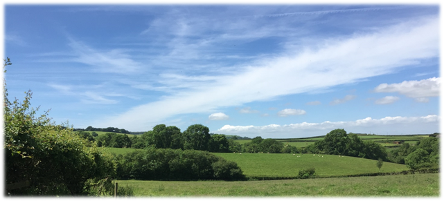
2.1 From the consultations on the Neighbourhood Plan, there was almost unanimous agreement that the landscape and scenery of the area was the most important factor in making the place special.
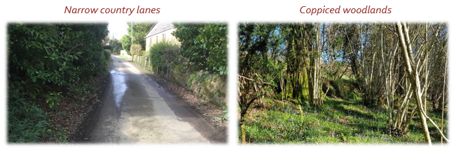
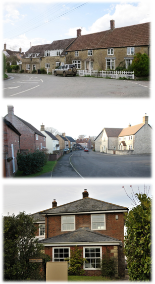
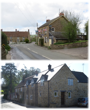
2.2 Much of the area falls within the undulating hills of Axe Valley, as described in the West Dorset Landscape Character Area Assessment (2009), which includes detailed descriptions of the characteristics of the area. It highlights the importance of deep, narrow winding lanes with their deep hedge banks, the predominance of grazed pastures that lead up to the open and undeveloped skylines, which afford long views over the rural landscape. These features can come under threat from both natural and human causes.
Table 1. Important landscape characteristics and features
2.3 The following policy does not seek to prevent development but to ensure that it integrates successfully within the area. However, in some cases alternative locations for development should be considered where the degree of harm to features of local landscape character would be substantial and cannot be avoided through sensitive design or mitigation. One such example might be where development would generate significant levels of pedestrian movements along narrow lanes with deep hedgebanks – where alternative off-road pedestrian routes may need to be considered as opposed to road widening.
Policy BGNP1. Local Landscape Features
Development should reinforce the local landscape character and its typical features, as noted in Table 1. Development that would result in the removal or degradation of these features without mitigation, will be resisted.
2.4 The intrinsically dark skies, that are a result of the rural nature of the area away from the main towns and other sources of light pollution, is a special quality of the Dorset AONB. Most towns (and many villages) in the UK have a ‘glow’ of light above them, caused by wasted light escaping upwards from street lights, flood lights and other light sources.
2.5 Outside of the area impacted by lighting from Broadwindsor village, the Neighbourhood Plan area enjoys some of the darkest night skies in the country (http://nightblight.cpre.org.uk/maps/). Although not all lighting falls within the control of planning, it is possible for Neighbourhood Plans to make clear the stance that should be taken where such development would require planning consent.
2.6 In response to the household questionnaire, the majority view was that more road and street lighting was necessary, although not everyone agreed (the divide was about 60% in favour, 40% against). Therefore the following policy isn’t looking to prevent lighting that may be required for safety or crime prevention reasons, but to ensure that unnecessary light pollution is prevented through considered and careful design in keeping with the rural character of the area.
Policy BGNP2. Dark Skies
Development should be designed to retain the dark skies, through minimising exterior lighting / illuminations and including measures to control light spillage and glare, particularly in areas of open countryside or on the edge of settlements. Street lighting should not be provided in developments unless required to address site-specific safety or operational issues. Where street lighting is required, heritage designs are to be preferred.
Map 2. Extent of the Dorset Area of Outstanding Natural Beauty
© Crown Copyright and database right (2019). Ordnance Survey Licence number 100060963
2.7 Local communities are encouraged to identify for protection those spaces within or close to settlements that are particularly valued, due to their recreational use, their historic significance, their wildlife value, or simply because they make such a strong contribution to the character of the area. The list of such spaces is provided in Table 2 that follows. These spaces can be designated as Local Green Spaces, which means that development in these locations will only be allowed in exceptional circumstances. Such a designation is meant to last beyond the lifetime of this Neighbourhood Plan.
| Ref | Description | Settlement | Reason for importance* |
| LGS 02 | Bridge Farm Green Space | Drimpton | Small roadside greenspace by stream, used for poppy memorial and on church processions |
| LGS 03 | St Mary’s Churchyard | Drimpton | A tranquil, secluded churchyard forming the setting of the church, a place for quiet reflection |
| LGS 05 | St John’s Churchyard | Seaborough | An attractive churchyard forming the setting of this historic church, a pleasant and tranquil place |
| LGS 07 /08 |
Axe Riverside - Crewkerne Road - NE and SW | Drimpton / Netherhay | Managed farmland alongside the Little Axe River – attractive and wildlife-rich river corridor |
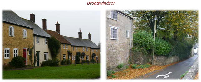
| LGS 09 | Netherhay Chapel Burial Ground | Netherhay | An attractive burial ground around a Grade 2 listed chapel, a tranquil spot to relax and reflect. |
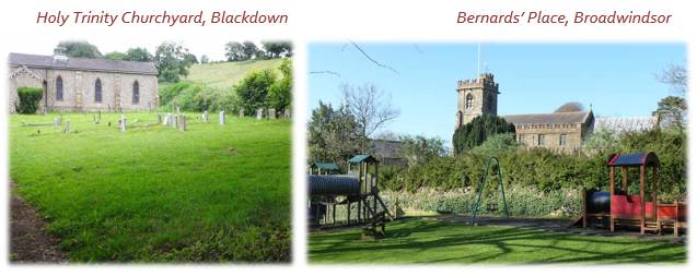
| LGS 13 | St John the Baptist’s Churchyard | Broadwindsor | An attractive churchyard forming the setting of this historic church, a place for quiet reflection. |
| LGS 14 | Bernards’ Place | Broadwindsor | An area bequeathed to the community, used for community events and a children’s playground. |
| LGS 16 | Hursey Playing Fields & Sports Ground | Hursey | Local playing fields and football pitch especially popular with village children and dogwalkers. |
| LGS 17 | Land adj Hyrst Down,Hursey | Hursey | An attractive, quiet area of land adjacent to Hyrst Down renowned for its wild flower meadow. |
| LGS 18 | St Andrew’s Churchyard | Burstock | An attractive churchyard forming the setting of this historic church, a pleasant and tranquil place |
| LGS 19 | Hursey Common | Hursey | Common Land designated by Dorset Wildlife Trust as a wildlife site, valued as a pleasant place to walk. |
| LGS 22 | Holy Trinity Churchyard | Blackdown | An attractive churchyard forming the setting of this rebuilt church, a pleasant and tranquil place |
See Appendix 1 for further details on each site, and Policies Map for their locations
2.8 The following policy sets out to protect these local green spaces from inappropriate development. This takes into account the fact that development adjoining these spaces can potentially impact on this enjoyment. For example, the introduction of a use that generates noise adjoining a local green space designated for its peace and tranquillity. However, other forms of development, such as new housing adjoining play areas, could provide a degree of natural surveillance that would improve the feeling of safety.
2.9 Local Green Space designation is not appropriate for community spaces where it is the use, but not the exact location, which is important. This is particularly relevant if the use could be relocated to another (and possibly better) site. As such, Broadwindsor School field, Drimpton recreation ground and play area, Broadwindsor Cricket Ground and Pavillion, Broadwindsor Allotments, and Oathill Allotments are protected, but under Policy BGNP7. The grounds of Broadwindsor House were also considered for designation as a Local Green Space, but instead have been included as a community space to allow this facility to expand and adapt – any such development would need to be carefully designed to avoid harm to the setting of the Listed building.
Policy BGNP3. Local Green Spaces
The local green spaces listed in Table 2 and shown in the Policies Map will be given special protection. Development within these areas will only be supported where it would enhance the enjoyment of the space and not undermine its importance. Development adjoining these areas must respect their reason for designation and should not significantly detract from their enjoyment.
2.10 There are many rural lanes and tracks which perform a similar role to the local green spaces, providing public access to enjoy the beautiful views and tranquillity of the Dorset AONB, with hedgebanks and verges home to local wildlife.
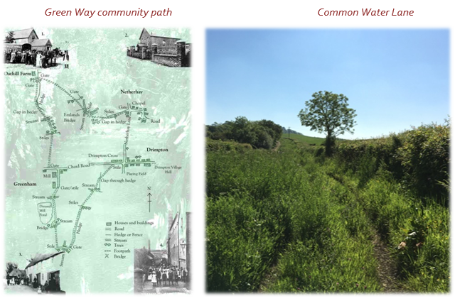
2.11 The Green Way Community Path is particularly notable. The definition of this path was a community group initiative from 1999, using sections of existing footpaths, to highlight the historic importance of this Green Way and its potential as an accessible circular recreational route. Crossing fields, the Green Way joins together Drimpton and its neighbouring hamlets of Oathill, Greenham, Childhay and Netherhay leading over land walked in the past by the hundreds of workers at Greenham Flax Mill, by the congregation of Netherhay Chapel, and by the farmworkers who worked the many farms.
2.12 Common Water Lane is the other notable track which is much enjoyed by local walkers, as part of the pre-Roman Wessex Ridgeway and the Monarch's Way. There are many wonderful views from this lane, and the Dorset Wildlife Trust has designated the verges on both sides as a Site of Nature Conservation Interest. There is a group (Friends of Common Water Lane) dedicated to its well-being.
Policy BGNP4. Green Way Community Path and Common Water Lane
Development should not result in the diversion of, or significantly detract from, the enjoyment of the Green Way Community Path or Common Water Lane as shown in the Policies Map
2.13 There are nearly 150 different protected or notable species recorded by the Dorset Environmental Record Centre in or close to the Neighbourhood Plan area. These include various birds (Black Kite, Red Kite, Short-eared Owl, Kingfisher), various species of Bat, and mammals such as the Hazel Dormouse, Water Vole, European Otter, Eurasian Badger and Polecat.
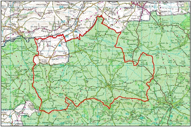
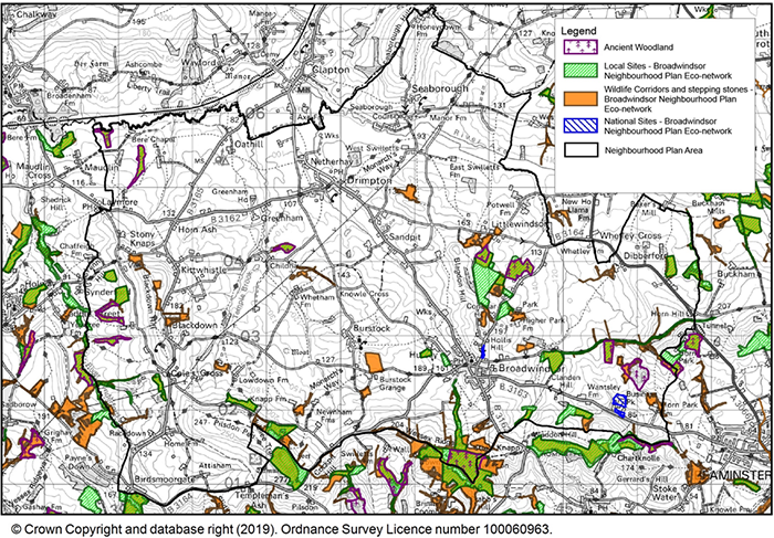
2.14 Two Sites of Special Scientific Interest have been designated in the area, noted for their geological formations (Horn Park Quarry and Conegar Road cutting). There is a much more extensive network of locally important nature conservation sites, as shown on the following map.
Policy BGNP5. Local Wildlife Corridors and Protected Species
All new development should have due regard for the local ecological network (existing and potential) as identified on Map 3, and potential presence of protected species; taking into account national policy to provide net gains in biodiversity where possible.
To achieve this, the potential adverse or beneficial impact of the development on these ecological networks should be fully evaluated, and presence of protected species checked. A Biodiversity Mitigation and Enhancement Plan must be submitted with any planning application for greenfield or brownfield development sites over 0.1ha in size where not currently used as existing residential or business premises, or with any planning application which is likely to give rise to an adverse impact on biodiversity.
Map 3. Sites of Special Scientific Interest and Ecological Networks
2.15 The AONB Management Plan makes particular reference to areas of higher ground that allow the observer uninterrupted panoramic views to appreciate the complex pattern and textures of the surrounding landscapes. Such views exist in the Neighbourhood Plan area, and although too many to mention, examples include:
Panoramic views across the AONB
2.16 Within the Conservation Area, the 2015 Appraisal notes the following important key views and vistas:
2.17 Large-scale and otherwise obtrusive developments can detract from the quality of views into, within and from the Dorset Area of Outstanding Beauty, and the Local Plan includes a policy to prevent harm to the special qualities and natural beauty of this valued landscape, including its uninterrupted panoramic views. Likewise the Local Plan policy on heritage assets makes clear that planning decisions should prevent harm to the key views and vistas within the Conservation Area.
2.18 The following descriptions are taken from the 2012 Parish Plan, updated to 2018:
2.19 Blackdown is a hamlet on the south-western part of the plan area. In mediaeval times, it was part of the ‘liberty’ of Broadwindsor and the ‘tithing’ of Childhay. It has a Chapel of Ease, consecrated in 1840 and until 1938 had its own school. Blackdown House started life in 1647 as a modest farm and has gradually been changed into the fine, large house it is today. There are various other farms and a structural steel construction company, which provide employment for the local population.
2.20 Broadwindsor nestles beneath Lewesdon hill, the highest point in Dorset. A lovely and lively community, and the largest settlement in the Neighbourhood Plan area, it clusters around the four roads that meet in the village square. When the church bells ring on a Sunday, three of them are so old they would have been heard in the 15th century, well before King Charles II stopped off in the village on his dramatic flight from the Battle of Worcester in 1651. Today, Broadwindsor has a thriving primary school, the White Lion pub, a renowned Craft Centre, and a community-run village shop. It is close to the much smaller hamlet of Hursey.
2.21 Burstock (‘Burewinestock’ in the Doomsday Book) is a small hamlet, located halfway up the south slope of the Axe valley west of Broadwindsor. Its single street has, at one end, a fine farmhouse with a 17th-century front and mullioned windows and at the other, the 13th century church of St. Andrew. Paintings of the village on the church’s south wall suggest Burstock has always been much the same size. Many of the families whose names can be read on the gravestones in the churchyard still farm or live in the area. Those who have moved away often come back to visit, or to be christened, married or buried here.
2.22 Childhay is a small hamlet linked to the Manor of Childhay, which belonged to the de Crukerne family in the time of Edward III. That manor house is built of stone, with a main hall-block and a kitchen wing dating from the C15, and the east porch is a good example of the late medieval period. The house was the scene of a skirmish during the Civil War. There is also a C16 barn and a C17 dairy. Childhay is a well-run farming enterprise and today incorporates small businesses premises including the famous Black Cow vodka producers and previously the well-respected Childhay Manor Ice Cream.
2.23 Drimpton is the second largest village in the parish and lies on the Little Axe, and close to the hamlets of Netherhay, Greenham and Sandpits. The village has a pub, the Royal Oak, with home cooked food and a skittle alley, and a place of worship, St Mary’s Church.
2.24 Drimpton village hall is a vibrant social centre for clubs and local entertainment, and has a play area and sports field outside. The hall itself has showers and changing facilities.
2.25 Greenham was built around a large flax mill (1824). At its peak the mill employed over 100 workers supplying the local Bridport rope industry. The mill is now much smaller and makes animal bedding. The workers cottages, Greenham House and Lower Greenham Farm make up this small hamlet.
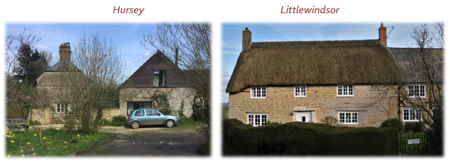
2.25 Hursey has a mixture of old and newer houses along the single lane that runs through this quiet settlement and past a working farm in to the countryside. The ancient Hursey Common is home to wildlife and wild flowers, but also boasts a much-loved sports field.
2.26 Kittwhistle is a very small hamlet that lies along the B3165 just north of its slightly larger neighbour Blackdown. It has two farms, a few houses and, famously, a garage which has been operating for over 70 years.
2.27 Littlewindsor is a hamlet, one mile north of Broadwindsor village. It is centred on a Manor Farm, which is shown in the Domesday Book as one of a large number granted by the Conqueror, for services rendered, to William de Mohun of Dunster in North Somerset. A century later the Abbots of neighbouring Forde Abbey were tenants of the Mohuns, but at the beginning of the C15, the Crown had become the Chief Lord with the Abbots continuing as tenants until the Dissolution, after which there was a succession of owners until the Cox family of Cheddington acquired the Manor in about 1790. Littlewindsor remains an agricultural and equine community.
2.28 Netherhay is a small hamlet with records back to the 16th century. Built around Netherhay Farm (now Old Netherhay) in 1683 by the Paul family. A chapel (now the Methodist Church) was built in 1838 for all the farm labours and workers at the flax mill in nearby Greenham.
2.29 Sandpits covers most of the farmland between Broadwindsor and Drimpton. It is a collection of traditional family farms and historic farmhouses, some of which are listed.
2.30 Seaborough is a ‘frontier’ hamlet and small parish in its own right, on the River Axe on the border with Somerset. Before 1896, it was in Somerset, and at that time it had only one farm and its steep main street would have required great skill to manoeuvre with a horse and cart. Horses are intrinsic to Seaborough and it is home to several farms and a very successful racehorse training stable which provides welcome employment in the parish.
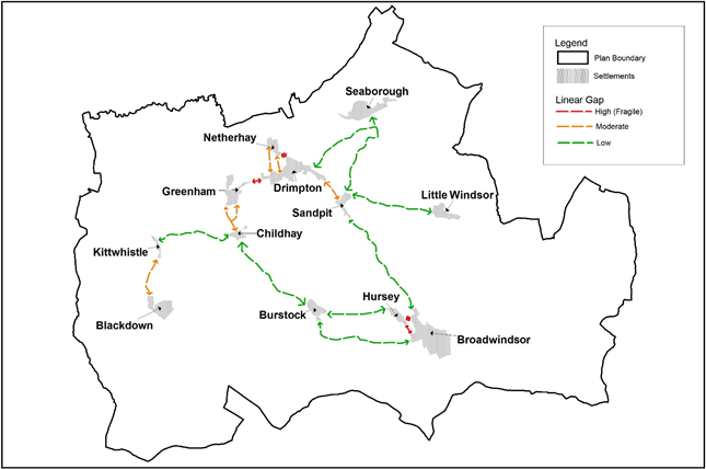
2.31 The importance of keeping the distinctive character of the different settlements was a clear theme that came out of the earlier consultations. Local residents were canvassed their opinion on the relative importance of gaps (as indicated in Map 4, with the length of the gap measured as the distance travelled along public routes or where clearly inter-visible) and whether insensitive development could potentially undermine the feeling of separation provided. The majority said that they considered the fragile and moderate gaps to be important or very important.
Map 4. Assessment of Settlements and Gaps
© Crown Copyright and database right (2019). Ordnance Survey Licence number 100060963
See Policies Map for more detailed definition of Important Gaps
2.32 It is clearly evident that the gaps between Broadwindsor and Hursey, Drimpton and Netherhay and Drimpton and Greenham are the most fragile due to the very limited separation. As such an important gap area has been defined on the Policies Map, within which development should not be permitted unless it would maintain the openness of these gaps. The moderate gaps between Drimpton and Sandpit, Greenham and Childhay, and Kittwhistle and Blackdown, are greater but still potentially vulnerable to erosion if significant development were to take place, and as such although some minor development may be permissible in the gaps between these settlements, the extent to which this may cumulatively impact on the distinction between settlements and their rural setting should still be considered, as should also be the case in the assessment of major development proposals (particularly in the context of the AONB where major development will be refused unless there are exceptional circumstances and the proposed development is in the public interest). The impact of any development on these gaps will be monitored to establish whether more clearly defined gaps between these larger settlements needs to be made in any future review of this Neighbourhood Plan.
2.33 There may be occasions where development in the gaps is unavoidable and in the public interest (for example infrastructure improvements where the location is fixed by other factors), in which case the landscaping and design of the development will require careful consideration.
Policy BGNP6. Important Gaps
New buildings, structures or land uses that would undermine the rural, undeveloped and open nature of the countryside, should not be permitted within the defined gaps shown on the Policies Map. Exceptions to this will only be supported where there are no alternative sites and the development would be in the overriding public interest, and provided that the landscaping and design of the development retain the rural character and function of the gap as far as possible.
Development in the countryside between Drimpton and Sandpit, Greenham and Childhay, and Kittwhistle and Blackdown, and the cumulative impact of minor development, should not compromise the rural setting of, and clear distinction between, these settlements.
2.34 With the many different types of buildings, settlements and materials used across the plan area, it is not an easy job to provide clear design guidance. The starting point should be to understand the characteristic of the settlement (or wider rural area) in which the development is planned, and develop a style that reinforces what is positive about that area’s local character. In some cases this will mean a building that blends in with its neighbours, in other cases it may be appropriate to introduce modern or innovative styles that still sit comfortably within their context, but add to that area’s character in a positive way.
2.35 A detailed Conservation Area Appraisal was adopted for Broadwindsor in October 2015 and provides much more detailed guidance for this particular area. As this area is designated for its historic and architectural interest, the guidance in the appraisal should be used.
www.dorsetforyou.gov.uk/article/387608/Netherbury-and-Broadwindsor-conservation-area
2.36 Elsewhere, the following table provides general guidance based on the typical characteristics found across the plan area, which should be considered in designs. The main thread running through all of these is the rural nature of the settlements, which have developed incrementally over many centuries, slowly evolving to changes in day-to-day living, such as the introduction of the motor car.
| Settlement Pattern and Layout | |
| a) The general settlement pattern across the area is one of dispersed, scattered, linear settlements, except the larger settlements of Broadwindsor and Drimpton, both of which are more concentrated in nature. b) Streets and lanes tend to be linear, with gentle meandering to provide interest and evolving views. The building line, where one exists, tends to be broadly aligned but with depressions and protrusions adding variety and character c) Within the settlements, the main façade and access to properties tends to face onto the street, with the main exception being farm buildings and courtyards. The inclusion of small front garden or paved areas with planters can avoid potential problems where buildings would otherwise exit directly onto the street d) The provision of external storage (for bins etc) and service boxes / meters etc should not appear unduly prominent. |
 |
| Building Type, Scale and Forms | |
| e) There is variation in building typologies, with groupings generally comprising a good variety, and reflecting the slow pace of growth and incremental changes typical of small rural settlements. There are examples of a range of terraced, semi-detached and detached dwellings in most settlements, including historic gentry houses and workers cottages alongside more modern-day equivalents, converted farm buildings and other building types evolved from the various rural industries that have taken place locally. f) Building heights are generally between one to two storeys, with occasional two-and-a-half (ie with 2 storeys plus dormer windows in the roof) and three storey (or equivalent) buildings including large barns, manor houses and congregational buildings. g) The typical roofline is pitched, some with gabled terminations, hips and half-hips and a comparative absence of gablets. Chimneys (often relatively simple and unadorned), have variation in pitch or height, and differentiated coping and kneelers, all adding interest. h) Breaks between buildings and in the roofline allow views of mature trees within gardens, and also out to the surrounding hills. |
 |
| Building Materials | |
| i) The main traditional building materials noted in the Conservation Area appraisal for Broadwindsor are Upper Greensand chert and rich orange colour Inferior Oolite limestone. Ham Hill Stone, Forest Marble and Chalk / Cob are also present in the plan area. Ashlared stone and dressed stone is commonly used in detailing such as ashlared window and door lintels or quoining. Fuller’s Earth clay has been used for brick making, and can be used to form lintels and quoins, in combination with stone rubble. Sheet materials are also encountered in commercial and farm buildings. j) There tends to be a hierarchy of stone quality according to the status of buildings: ashlar on the Church and gentry houses; dressed stone or squared and coursed rubble on cottages; and rubble on agricultural buildings and boundary walls. k) Roof coverings include tile, slate, thatch, pantiles and sheet materials, including metal and fibre-cement. Thatch roofs are less common in the eastern part of the plan area. Chimneys are typically brick. l) Boundary treatments that complement local character tend to be low walls made of brick or stone (typically uncoursed rubble), wrought or cast ironmongery or hedgerows or a combination of these. The use of cheap panel fencing in publicly visible boundaries tends to detract from the streetscene. |
 |
| Architectural Details | |
| m) Porches and canopies are relatively common and varied, the Conservation Area appraisal notes solid stone and rendered types with slate or tile roofs to bracketed flat and gabled canopies. n) Door types and materials are mixed, with more traditional buildings typically wooden, with vertical planks, plain or with expressed or studded muntins, with and without glazed openings; including rectangular, segmental or semi-circular fanlights over. o) Depending on the age and style of building, windows may be spaced at regular intervals or more randomly placed. Sash and casement windows are most common, but the Conservation Area appraisal notes the use of hollow-chamfered stone mullions, horizontally hung wooden casements, vertically sliding sash windows, with varying numbers of glazing bars. Lintels vary from stone, wood and brick, and include cambered arches. |
 |
2.37 In respecting local character, it is important to remember that many of the older buildings would not meet today’s more rigorous building regulations for modern living, and were not necessarily designed with today’s requirements for servicing and infrastructure in mind. Half of all households own 2 or more cars, and therefore will require space to park. Storage requirements mean that households have at least two wheelie bins, plus other containers, required for rubbish and recycling. Meter boxes etc should be discreetly placed.
2.38 Patterns of energy use and generation will continue to develop, spurred on by rising energy costs, and lack of mains gas as a viable alternative. As a result, options for renewable energy will increasingly be investigated on existing buildings and as part of new developments. Such options, whether PV panels, or even plug-in points for electric cars, are best considered at the start, when they can be sensitively included in a scheme.
Policy BGNP7. Built character
Development should be designed to complement and reinforce the distinctive local character of the settlement or outlying rural area to which it relates. This should include reference to and consideration of all of the following key characteristics, as described in more detail in Table 3:
< Previous | ^ Top | Next >