
The purpose of this section is to provide insight into the characteristics, in terms of the built environment, of the area covered by this neighbourhood plan.
Bridport’s role as a historic market town servicing the surrounding countryside continues to this day. Almost 15,000 people make their permanent home within the neighbourhood plan area, which is also a popular holiday destination and a preferred place for people to retire to.
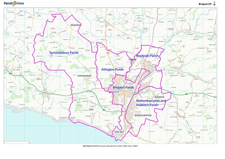
The neighbourhood plan area, which covers the parishes of Allington, Bothenhampton & Walditch, Bradpole, Bridport & West Bay and Symondsbury, is located entirely in a designated Area of Outstanding Natural Beauty and its coastline, the “Jurassic Coast”, is designated as a Heritage Coast and a UNESCO World Heritage Site. The area has a rich and diverse heritage recognised in over 515 Listed Buildings, six Conservation Areas and many locally valued buildings, structures and distinctive features.
Any development within the neighbourhood plan area should be in keeping with, or complementing, the character of the environment in which it is located. Conservation Area boundaries, development history and heritage character are described in detail in dedicated council reports (reference Heritage Section) and new developments within these areas will be assessed for suitability against established criteria. Outside Conservation Areas, as can be seen from the photographs in this section, there is a rich diversity of character thus development proposals will need to be assessed on a case-by-case basis.
Since a majority, if not all, new development will lie outside the Conservation Areas the focus here is on the characteristics outwith these areas, taking each parish as a basis.
Map 2 The Neighbourhood Plan Area and Parish Boundaries (unchanged)
Allington parish has no designated Conservation Areas. The parish is home to several farms. Most of North Allington and West Allington homes lie within the Bridport town boundary, not Allington parish.
To the south-west of the parish lies the housing development of West Mead and Lodge Lane, a mix of neo-Georgian and rustic style homes, the latter a mix of brick and stone and some with thatched roofs.
East of Bridport Community Hospital is a compact estate comprised of two-storey semi-detached houses on small plots, with tight roads often ending in cul-de-sacs. The architectural design is characterised by two-storey homes and bungalows to the south, all in red brick with pitched roofs.
Further east straddling the Allington and Bridport parish boarder is Court Orchard built as a classic ‘council house estate’ and the recent development of Dibden View with its contemporary homes including some that were self-built.
The site of the Bridport Co-housing Community Land Trust Hazelmead Eco-home development is west of the Bridport Community Hospital.
Bridport is the main settlement within the neighbourhood area. It is a market town about 1.5 miles (2.4 km) inland from Lyme Bay near the confluence of the River Brit and its tributaries the Asker and Symene. Its origins are Saxon, and it has a long history as a ropemaking centre and of fishing and ship building from West Bay.
Since the Middle Ages, Bridport has been associated with the production of rope and nets.
The raw materials needed, flax and hemp, used to be grown in the surrounding countryside, though they were superseded in modern times by artificial fibres such as nylon. Today, the manufacture of rope and nets is still important to the economy of the town.
Bridport was granted a royal charter by Henry III in 1253 and another in 1594 by Elizabeth I to hold a market and three fairs. The town celebrates the charters each year at the annual charter fair. Other events are held in Bridport including the ropewalk fair, carnival, and the torchlight procession which trails its way down to West Bay (originally called Bridport harbour). The town also holds music festivals, The Melplash Show, a hat festival, and ‘Christmas Cheer’. In the 21st Century, Bridport’s arts scene has expanded with an arts centre, theatre, cinema, and museum. Many artists have settled locally.
Bridport’s main streets are particularly wide due to previously having been used to dry the ropes, after they had been spun in long gardens behind the houses. Today, these wide streets are home to the twice weekly market, which complements the many independent shops, cafes and pubs in East, South, and West streets.
Working in studios scattered around the Bridport area artists to exhibit their work during Dorset Art Weeks and Bridport open studios. The town is twinned with Saint-Vaast-la-Hougue, a fishing village on the Cherbourg peninsula, France.
The historically significant areas of Bridport, including St. Michael’s trading estate, are largely defined by the Conservation Area boundary. West Bay, the bulk of which is within Bridport parish, is almost entirely a conservation area. Bridport has a good range of late 18th and 19th century industrial buildings and terraces of factory housing dating from the early 19th century, largely associated with the rope making industries.
Housing shortages following the First World War led to the development of a public housing scheme west of the town on Skilling Hill. Subsequent development in the Skilling area has created a relatively dense mix of bungalows, houses and flats.
Other small suburban districts, typical of their period, include St. Swithun’s with its numerous flats, Court Orchard, and land south of St. Mary’s church, also incorporating a number of flats. The most recent larger developments are Meadowlands to the east of West Bay Road and New Zealand Close east of South Street car park. Immediately to the north of this car park is the Church Street development that also included sensitive refurbishment of an old building.
Edwards Close, to the west of the Medical Centre, is a recently completed affordable home exception site. St. Michael’s Trading Estate is the site of a planned development for the major refurbishment of existing commercial premises and construction of new homes.
Bridport is home to light industry and trading estates including Dreadnought, Court Mills, and straddling the Bridport & Bradpole parishes, North Mills.
Bothenhampton has a small historic core in the form of a linear settlement flanking Main Street that is a designated Conservation Area. Walditch’s historic core and Conservation Area, nestled in countryside, flanks Walditch Road to the east of the parish somewhat remote from the newer built up areas.
The 20th Century saw a large suburban addition on the western flank and north west corner of the parish with predominance of bungalows on large plots, with winding cul-de-sacs. These are largely clad in red or grey brick and are accompanied by garages.
Crock Lane and Lower Walditch Lane provide the spine for housing and in the north-eastern flank of the Parish lies the most recent development of homes. The reduction in plot size is substantial creating a higher density estate. The architectural design uses a wide range of cladding materials to achieve variation in appearance, such as light-coloured render, red brick, and stone.
Bradpole has a historic core of deep sunken lanes and stone houses to the north-east of the parish that comprises its Conservation Area. The northern part of the parish is a large tract of hedged farmland.
To the north, west and south of the historic core lies predominantly 20th Century residential development. The architectural design here varies from bungalows on large plots as typically seen in Jessopp Avenue, to more tightly grouped two-storey homes and bungalows. The materials used range between red brick, render and pebbledash.
The parish is home to St Catherine’s Primary and Colfox Academy schools and a substantial business park to the north.
The village of Pymore straddles the Allington and Bradpole parish boundaries. It has a mix of old and more modern homes (predominantly red brick) including some sensitive fusing of the old and new. There is also a small industrial estate. The hamlet of Pymore is bisected by the River Brit and falls within the parishes of Bradpole to the east and Allington to the west of the river. The river was the centre of the local industry, initially powering the mills that originally produced flour.
By the 1700’s Pymore had developed a reputation for rope making using locally grown flax. The industry used to employ many of the people living within the village and some of those workers cottages still exist at Pymore Terrace.
The remnants of the rope making industry ceased in the mid 20th century and after a period of dereliction the village was refurbished at the beginning of the 21st century by blending modern housing with the old industrial buildings. This harmony of the old and the new presents a settlement of some 100 dwellings that has a particular character.
Symondsbury parish is predominantly farmland within which there are four main settlements; Symondsbury Village, Eype, Broadoak and West Cliff.
The historic and picturesque Symondsbury village is a Conservation Area and has seen no significant new building over the last decades. The independent village of Eype by the coast also has a Conservation Area and has also seen little significant development in recent years. Broadoak to the north is a widely spread rural hamlet.
Eype means "steep place" and extends for about a mile from 19th century St. Peter’s Church to the coast. Many of the village buildings can be traced back to the late eighteenth or early nineteenth century and there is a pub and old school room, caravan parks and hotel.
Broadoak is made up of several farming communities, some with houses going back to 16th century, and has a small 19th century church, village hall, small craft centre and restored phone box!
West Cliff is a private estate originating from the 1920s on land purchased by three local businessmen from the Earl of Ilchester. Covenants were set up to ensure that all the houses maintained a view of the sea and though it has been extended since that time, it retains that distinctive air.
Symondsbury parish will be home to the planned Vearse Farm major urban extension.
< Previous | ^ Top | Next >