
1.1 National planning policy requires that the District meets objectively assessed needs for housing (OAN), including any unmet needs from neighbouring authorities where it is practical to do so and is consistent with achieving sustainable development. Councils should identify needs in their area, and respond positively to wider opportunities for growth.
1.2 With a growing population, an ageing population and future changes in household make-up, the need for housing within Three Rivers continues to be high and is increasing. New development is an important responsibility that we have in order to help ensure that future generations can find homes of their own.
1.3 As a Council, we acknowledge that there is an acute housing crisis in much of the UK and in particular high-cost areas like Three Rivers, and a pressing need for more homes, especially more affordable homes, so young people are not forced to move away from the area, but that this cannot be addressed at the cost of harming existing communities and reducing the quality of life and wellbeing of our residents
1.4 The Council undertook a Regulation 18 consultation in the summer of 2021. This was presented in two parts. Part 1: Preferred Policy Options and Part 2: Sites for Potential Allocation. Please refer to the Part 1 of the consultation for an overall explanation of the Local Plan, its purpose and requirements and how the Council has arrived at this Regulation 18 consultation. This can be found on the Council's website at: https://www.threerivers.gov.uk/egcl-page/new-local-plan
1.5 This document forms Part 3 of the Local Plan Regulation 18 consultation and sets out additional potential sites where development could take place, how much additional development may take place, and when.
1.6 All the additional sites identified as having potential for allocation are for residential development and associated infrastructure. Please refer to Part 2 of the consultation for the previously recommended sites for housing as well as the following land uses: gypsy and traveller and travelling showpeople accommodation, employment (including Leavesden Studios), town centre and retail development, open space and education. Part 2 of the consultation also included the proposed revision of the Green Belt boundary in relation to Bedmond.
1.7 As a result of last year's consultation a further 18 sites were submitted for the Council's consideration. A further three sites we re-submitted with updated proposals. Individual site assessments for these potential site allocations for housing have been undertaken as part of the Strategic Housing & Employment Land Availability Assessment (SHELAA) addendum1, which can be viewed at: https://www.threerivers.gov.uk/egcl-page/new-local-plan-evidence-base.
1.8 The introduction to Part 1 (2021) of this consultation document sets out the considerations and evidence base studies taken into account in arriving at the Additional Sites for Potential Allocation that are included in this document.
1.9 The additional sites identified as potential site allocations for housing have been arrived at following extensive technical work and evidence gathering. Subsequently, and in line with national planning policy, these sites are considered to be the most appropriate in having the potential for housing development2 and associated infrastructure.
1.10 It should be noted from the outset that if any of the potential housing sites for allocation are later found to no longer be suitable for allocation following this consultation, then the Council may need to identify other sites to contribute towards meeting its housing need.
1.11 As stated in the overall introduction to the Local Plan Regulation 18 consultation (in Part 1 of this consultation), this is not the final stage of the Plan as we are still awaiting some key pieces of evidence. Your views submitted as part of this consultation will help inform the next stage and ultimately the document to be submitted to the Secretary of State. Following submission to the Secretary of State, there will then be an examination by an independent Inspector before the Council can adopt the document3.
1.12 An online map has been produced showing all of the existing and potential sites for allocation included within this public consultation document and the Regulation 18 Part 2 document. The online map is viewable at the following webpage: http://www.planvu.co.uk/trdc/localplanconsultation2021.
1.13 Maps including the sites considered suitable for for potential allocation as well as those that were considered unsuitable can be viewed in the appendices to this document.
2.1 Part 1 (2021) of this consultation sets out the plan period that the Local Plan will cover and the number of dwellings required to meet its objectively assessed needs. The Housing Target for the Local Plan is 12,624 dwellings based on the Government's standard method for calculating housing need. Once completions, commitments through planning permissions and a windfall allowance is taken into account this results in a residual Housing Target of 10,678 dwellings.
2.2 Part 2 (2021) of the consultation identified sites that could deliver 8,973 dwellings. This was 1,705 dwellings short of the Government's residual Housing Target. The additional sites included in this document identify sites for a further 825 dwellings. It should be noted that a 438 dwelling reduction in this figure has now occurred as 9 sites have been removed from the Part 2 document following site owners' withdrawal or statutory bodies' objections and a further three sites' dwelling capacities have been reduced leaving a deficit of 1,318 dwellings on the government target.
2.3 It should be noted that two of the sites proposed for potential allocation are located in Bedmond. Although Bedmond has been proposed for insetting in the Green Belt, it remains a village in the Council's settlement hierarchy. As such, the cumulative impact of development on the village needs to be considered. With this in mind two of the three sites proposed for potential allocation in the Regulation 18 Part Two: Sites for Potential Allocation document are being recommended to be removed as the two sites replacing them are considered more suitable. This will result in 50 fewer dwellings being proposed for Bedmond village. The Part 2 sites proposed for removal are site CFS10 Land between Millhouse Land and Bell Lane, and site ACFS9e Land west of Bedmond Road. The sites' location maps can be viewed in Appendix 2.
2.4 Please refer to Part 2 of the consultation to view the proposed policy on housing allocations.
2.5 The additional potential housing site allocations are shown in site tables below for each settlement area, as listed below:
| Settlement | Sites |
|---|---|
| Bedmond | NSS2 NSS6 |
| Kings Langley | NSS10 CFS26e |
| Abbots Langley | NSS14 CFS8d |
2.6 The site tables for the potential housing allocations include the following information:
2.7 The comments section in the site tables set out site-specific requirements and/or measures that would need to be addressed in proposals for the sites. It should be noted that these are in addition to matters set out in the detailed preferred policy options set out in Part 1 of this consultation, including requirements relating to affordable housing and sustainable transport provision and net gain in biodiversity value. The site specific requirements/measures are not exhaustive but seek to aid future considerations by identifying key constraints and considerations which are specific to sites. As stated, all future proposals would need to comply with the full suite of policies in the Local Plan.
2.8 The additional potential housing allocations below provide for an indicative capacity of 8255 dwellings in addition to the 8,973 dwellings provided for in Part 2 of the consultation. The total indicative number of dwellings being provided for by the Regulation 18 consultation as a whole6 is 9,797 dwellings.
2.9 The site tables for the 6 additional potential housing allocations are shown below
2.10 Appendix 1 provides a summary of the 15 new sites suggested by landowners. These are not included in the consultation following evaluation by officers and decisions by Members. It was deemed that all these sites were unsuitable for development for a number of reasons relating to each site. The Strategic Housing & Employment Land Availability Assessment (SHELAA) site assessments for these sites together with those proposed for potential allocation can be viewed at: https://www.threerivers.gov.uk/egcl-page/new-local-plan-evidence-base.
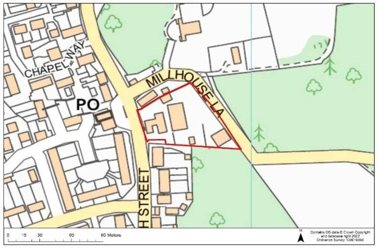
NSS2: 56 High Street, Bedmond
| Site Ref. | NSS2 | Site | 56 High Street, Bedmond | Size (ha): | 0.4 |
 |
Current Use | Car dealership, MOT centre and service station | |||
| Dwelling Capacity | 20 dwellings | ||||
| Phasing | 0-5 years | ||||
| Green Belt | Yes. Previously developed land in the Green belt. | ||||
| Comments Suitable mitigation to address surface water flooding and ground water flooding would be required. There are no heritage assets within the site boundary, although there are two Grade II Listed Buildings to the north and south of the site and Locally Listed Buildings located to the south, on High Street. A landscape visual assessment will be required in order to mitigate any potential adverse impacts. | |||||
Question 1 Do you agree that site NSS2 is an appropriate development site? If not, please explain why. |
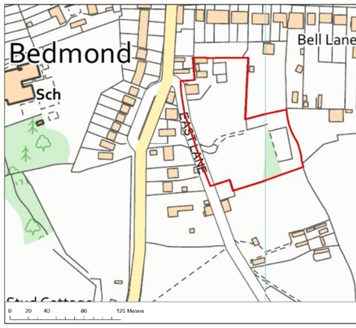
NSS6: North Cott, East Lane, Bedmond, WD5 OQG
| Site Ref. | NSS6 | Site | North Cott, East Lane, Bedmond, WD5 OQG | Size (ha): | 1.2 |
 |
Current Use | Grassland (south) Equestrian ménage & sheds (east) |
|||
| Dwelling Capacity | 12 dwellings | ||||
| Phasing | 0-5 years | ||||
| Green Belt | Yes. If allocated, the Green Belt boundary would have to be revised. The site is partially within and partially adjacent to the village of Bedmond and the proposed inset area. | ||||
| Comments Any development proposals on the site should be accompanied by a pre-application or pre-determination archaeological assessment. Suitable mitigation to address the risk of surface water flooding would be required to the east of the site. HCC Highways advise access from East Lane is not suitable for any development, an access solution would be needed before any consideration and a shared surface solution would not be acceptable. It is also expected that enhanced crossing facilities of High Street would be needed. Development would also need to take into consideration the heritage assets within the vicinity of the site. | |||||
Question 2 Do you agree that site NSS6 are appropriate development site? If not, please explain why. |
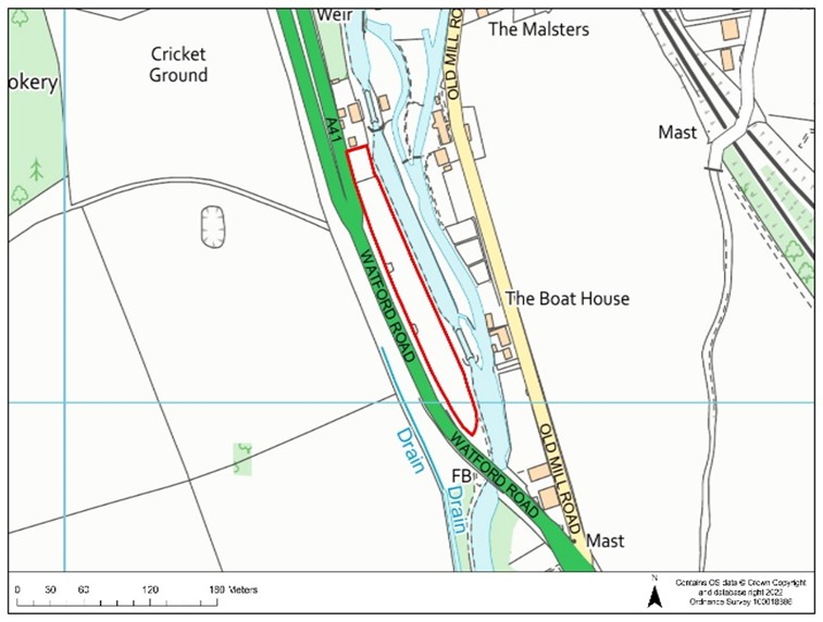
NSS10: Land at Mill Place, Hunton Bridge
| Site Ref. | NSS10 | Site | Land at Mill Place, Watford Road, WD4 8QS | Size (ha): | 0.6 |
 |
Current Use | Storage | |||
| Dwelling Capacity | 20 dwellings | ||||
| Phasing | 0-5 years | ||||
| Green Belt | Yes. Does not require green belt boundary revision. | ||||
| Comments An 8m buffer would be required as part of any development proposals between residential development and the site's proximity to the River Gade/ Grand Union Canal. Noise issues caused by the site's proximity to the A41 may have an impact on the site and its future occupiers and as such noise reduction measures should be considered as part of the design of the scheme. A detailed heritage impact assessment may be required as part of any proposals, due to the proposals potential impact on Langleybury and The Grove, which contains a number of nationally Listed Buildings. | |||||
Question 3 Do you agree that Site NSS10 is an appropriate development site? If not, please explain why. |
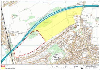
CFS26e: Kings Langley Estate South
| Site Ref. | CFS26e | Site | Kings Langley Estate | Size (ha): | 22 |
 |
Current Use | Agricultural use | |||
| Dwelling Capacity | 380 | ||||
| Phasing | 6-10 years | ||||
| Green Belt | Yes. If allocated, the Green Belt boundary would have to be revised. | ||||
| Comments This is a large site and its development would support additional infrastructure provision. Any proposals should take account of the presence of the Woodland and Protected Trees within the site. Small areas of the site are at risk of surface water flooding and future proposals would need to satisfactorily address this and provide suitable mitigation where necessary. Noise and air quality issues caused by the site's proximity to the M25 should also be taken into account as part of any future development proposals. The land to the east of the site is proposed to be allocated as public open space, shaded yellow on the above plan, as part of the planning gain the site is expected to deliver. | |||||
Question 4 Do you agree that Site CFS26e is an appropriate development site? If not, please explain why. |
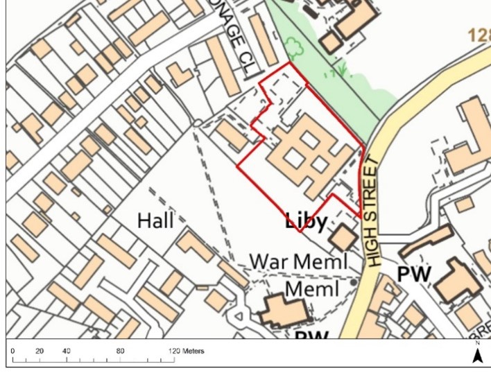
NSS14: Margaret House, Abbots Langley
| Site Ref. | NSS14 | Site | Margaret House, Abbots Langley | Size (ha): | 0.66 |
 |
Current Use | Disused residential Care Home | |||
| Dwelling Capacity | 25 dwellings (net) | ||||
| Phasing | 0-5 years | ||||
| Green Belt | No. Brownfield site | ||||
| Comments Development would need to take into consideration the heritage assets within the vicinity of the site, the presence of the adjacent Local Wildlife Site. There is existing vehicular access provision from Parsonage Close at the northern boundary of the site. HCC Highways state access would need further work, including on the suitability of Abbots Road. | |||||
Question 5 Do you agree that Site NSS14 is an appropriate development site? If not, please explain why. |
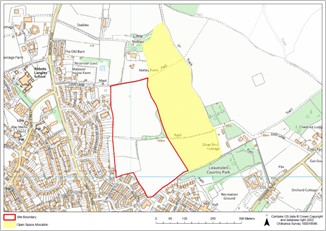
CFS8d: Notley Farm, Abbots Langley
| Site Ref. | CFS8d | Site | Notley Farm, Bedmond Road | Size (ha): | 11.4 |
 |
Current Use | Agricultural land | |||
| Dwelling Capacity | 450 dwellings | ||||
| Phasing | 6-10 years | ||||
| Green Belt | Yes. If allocated, the Green Belt boundary would have to be revised. | ||||
| Comments HCC Historic Environment advise that the site includes/has potential to include heritage assets of archaeological interest. Any development proposals on the site should be accompanied by a pre-application or pre-determination archaeological assessment. Suitable mitigation will be needed to address surface water flooding as there are two large surface water flow paths crossing the site, running along the southern boundary and through the centre of the site from the south-eastern corner. Suitable access to the site through the adjacent site (Site CFS8a) from Shepherd Close is considered to be unachievable. Development proposals will need to address suitable access. The land to the east of the site, shaded yellow on the above plan, is proposed to be allocated as public open space and improvements to the allotments to the west of the site will be provided as part of the planning gain the site is expected to deliver. | |||||
Question 6 Do you agree that site CFS8d is an appropriate development site? If not, please explain why. |
1 Assessments of the additional sites which have not been included in this document are also included in the Strategic Housing Land Availability Assessment Addendum (2022).
2 Appendix 2 provides a summary of the additional sites that were included in the SHELAA addendum which are not being taken forward
3 Details of the timetable are set out in the Local Development Scheme at: https://www.threerivers.gov.uk/egcl-page/local-development-scheme
4 This relates to the number of years following adoption of the Local Plan as set out in the Council's Local Development Scheme https://www.threerivers.gov.uk/egcl-page/local-development-scheme.
5 This figure is net gain so the dwelling capacities for the two sites removed from Bedmond (Appendix 2) have not been included.
6 All the housing sites in Part 2 and the Part 3 of the Regulation 18 consultation together