
2.1 National planning policy requires that the District meets objectively assessed needs for housing (OAN), including any unmet needs from neighbouring authorities where it is practical to do so and is consistent with achieving sustainable development. Councils should identify needs in their area, and respond positively to wider opportunities for growth.
2.2 With a growing population, an ageing population and future changes in household make-up, the need for housing within Three Rivers continues to be high and is increasing. New development is an important responsibility that we have in order to help ensure that future generations can find homes of their own.
2.3 The new Local Plan is anticipated to be adopted in May 2023 in accordance with the Local Development Scheme (December 2020); national policy requires that a Local Plan should plan for a 15 year period following adoption. The new Local Plan period will therefore be 2018 – 2038.
2.4 For the 15 year plan period following adoption of the Local Plan the Government’s Standard Method for calculating housing needs has been used of 630 dwellings per year. The Housing Target for the Local Plan will therefore be 12,624 dwellings based on the standard method for calculating local housing need.
2.5 However, taking account of completions and commitments through planning permissions since 2018 together with a windfall allowance, the residual Housing Target as of 31 March 2020 is 10,678 dwellings. The Council seeks to meet as much of the identified need for housing as possible given the ecological, environmental and policy constraints.
2.6 The proposed policy on housing allocations is set out below.
| Proposed Policy on Housing Allocations |
|
Question 1 Do you think the Proposed Policy for Housing Allocations is the right approach? If not please identify how the proposed policy could be changed. |
2.7 The potential housing site allocations are shown in site tables below for each settlement area, as listed below:
| Abbots Langley & Leavesden Bedmond Garston Kings Langley Langleybury Croxley Green Rickmansworth Mill End Chorleywood Maple Cross & West Hyde Moor Park & Eastbury Oxhey Hall South Oxhey Carpenders Park |
2.8 The site tables for the potential housing allocations include the following information:
2.9 The comments section in the site tables set out site-specific requirements and/or measures that would need to be addressed in proposals for the sites. It should be noted that these are in addition to matters set out in the detailed preferred policy options set out in Part 1 of this consultation document, including requirements relating to affordable housing and sustainable transport provision and net gain in biodiversity value. The site specific requirements/measures are not exhaustive but seek to aid future considerations by identifying key constraints and considerations which are specific to sites. As stated, all future proposals would need to comply with the full suite of policies in the Local Plan.
2.10 The potential housing allocations included below provide for a total indicative capacity of 8,973 dwellings.
2.11 The site tables for the potential housing allocations are shown below.
2.12 Appendix 2 provides a summary of the sites that were included in the Strategic Housing & Employment Land Availability Assessment (SHELAA) which have not been taken forward.
ABBOTS LANGLEY & LEAVESDEN
CFS3:
| Site Ref. | CFS3 | Site | Land adjacent to Fraser Crescent and Woodside Road | Size (ha): | 7.1 |
 |
Current Use | Open grazing land | |||
| Dwelling Capacity | 303 | ||||
| Green Belt | Yes. If allocated, the Green Belt boundary would have to be revised. | ||||
| Phasing | 1-10 years | ||||
| Comments Any development would be required to take account of the presence of protected trees within the site and public rights of way adjacent to the site. A detailed heritage impact assessment would be required prior to any development in order to protect and mitigate any potential adverse impacts to heritage assets in the vicinity of the site. There is a sewer to the west of the site which would need to be protected as part of any development. Upgrades to the wastewater network would likely be required if the site were to be developed. The site would be required to provide open space and play space. |
|||||
Question 2 Do you agree that that Site CFS3 is an appropriate development site? If not, please outline your reasons. |
CFS4:
| Site Ref. | CFS4 | Site | Land at Warren Court, Woodside Road | Size (ha): | 0.54 |
 |
Current Use | Former private allotment land (used by Warren Court Mental Health Impatient Unit) | |||
| Dwelling Capacity | 26 | ||||
| Green Belt | Yes. If allocated, the Green Belt boundary would have to be revised. | ||||
| Phasing | 1-5 years | ||||
| Comments Any development would be required to take account of the presence of protected trees within the site. An archaeological assessment would be required prior to any development in order to protect and mitigate any potential adverse impacts to heritage assets of archaeological interest. The site would be required to provide open space and play space. |
|||||
Question 3 Do you agree that that Site CFS4 is an appropriate development site? If not, please outline your reasons. |
CFS6:
| Site Ref. | CFS6 | Site | Land at Mansion House Equestrian Centre, Abbots Langley | Size (ha): | 2.8 |
 |
Current Use | Grazing land | |||
| Dwelling Capacity | 133 | ||||
| Green Belt | Yes. If allocated, the Green Belt boundary would have to be revised. | ||||
| Phasing | 1-10 years | ||||
| Comments Any development of the site would need to take account the public right of way adjacent to the site boundary. A detailed heritage impact assessment and an archaeological assessment would be required prior to any development in order to protect and mitigate any potential adverse impacts to heritage assets. The site would be required to provide open space and play space. |
|||||
Question 4 Do you agree that that Site CFS6 is an appropriate development site? If not, please outline your reasons. |
CFS26c:
*This site (Site CFS26c) is also included in the Kings Langley section*
| Site Ref. | CFS26c | Site | West of the Kings Langley Estate | Size (ha): | 25.5 |
 |
Current Use | Open land Agricultural |
|||
| Dwelling Capacity | 893 | ||||
| Green Belt | Yes. If allocated, the Green Belt boundary would have to be revised. | ||||
| Phasing | 6-15 years | ||||
| Comments Part of the site is designated as a Local Wildlife Site and measures to avoid adverse impacts and enhance biodiversity would need to be provided. Any development would also be required to take account of the presence of protected trees and public rights of way within the site as well as providing suitable mitigation to address surface water flood risk in areas of the site. There are Locally Listed Buildings to the west and south-west of the site and any development would need to protect and mitigate any potential adverse impacts to these heritage assets. Potential noise and air quality issues arising from the site’s proximity to the M25 would also need to be addressed. Upgrades to the wastewater network would likely be required if the site were to be developed. The site would be required to provide a primary school, open space and play space. |
|||||
Question 5 Do you agree that that Site CFS26c is an appropriate development site? If not, please outline your reasons. |
PCS21:
| Site Ref. | PCS21 | Site | Land at Love Lane | Size (ha): | 1.3 |
 |
Current Use | Open grassland | |||
| Dwelling Capacity | 62 | ||||
| Green Belt | Yes. If allocated, the Green Belt boundary would have to be revised. | ||||
| Phasing | 1-5 years | ||||
| Comments Any development of the site would need to take account the public right of way adjacent to the site boundary. A detailed heritage impact assessment and an archaeological assessment would be required prior to any development in order to protect and mitigate any potential adverse impacts to heritage assets. Suitable access arrangements would need to be achieved at the planning application stage. Upgrades to the wastewater network would likely be required if the site were to be developed. The site would be required to provide open space and play space. |
|||||
Question 6 Do you agree that that Site PCS21 is an appropriate development site? If not, please outline your reasons. |
EOS4.0:
| Site Ref. | EOS4.0 | Site | Land adjacent to Bedmond Road & South of M25, Abbots Langley | Size (ha): | 10.18 |
 |
Current Use | Agricultural and equestrian uses | |||
| Dwelling Capacity | 319 | ||||
| Green Belt | Yes. If allocated, the Green Belt boundary would have to be revised. | ||||
| Phasing | 1-10 years | ||||
| Comments A detailed heritage impact assessment would be required prior to any development in order to protect and mitigate any potential adverse impacts to heritage assets. Potential noise and air quality issues arising from the site’s proximity to the M25 would also need to be addressed as part of any development. A buffer between the M25 and residential development would be required. Part of the site is permissioned for a change of use to equestrian use and the development of a stable building, ménage and associated parking, which has recently been completed and would need to be protected as part of any development. The site would be required to provide open space and play space. |
|||||
Question 7 Do you agree that that Site EOS4.0 is an appropriate development site? If not, please outline your reasons. |
AB18:
| Site Ref. | AB18 | Site | Garage Courts, Parsonage Close | Size (ha): | 0.09 |
 |
Current Use | Garages | |||
| Dwelling Capacity | 6 | ||||
| Green Belt | No | ||||
| Phasing | 11-15 years | ||||
| Comments Any development of the site would need to take account of protected trees located along the northern boundary of the site as well as the public right of way which runs along the northern boundary. |
|||||
Question 8 Do you agree that that Site AB18 is an appropriate development site? If not, please outline your reasons. |
AB26:
| Site Ref. | AB26 | Site | Garages, Tibbs Hill Road | Size (ha): | 0.1 |
 |
Current Use | Garages | |||
| Dwelling Capacity | 7 | ||||
| Green Belt | No | ||||
| Phasing | 11-15 years | ||||
| Comments Any development of the site would need to protect heritage assets in the vicinity of the site. |
|||||
Question 9 Do you agree that that Site AB26 is an appropriate development site? If not, please outline your reasons.. |
AB31:
| Site Ref. | AB31 | Site | Garages, Jacketts Field | Size (ha): | 0.08 |
 |
Current Use | Garages | |||
| Dwelling Capacity | 6 | ||||
| Green Belt | No | ||||
| Phasing | 11-15 years | ||||
| Comments Any development would need to provide suitable mitigation to address surface water flood risk on areas of the site. |
|||||
Question 10 Do you agree that that Site AB31 is an appropriate development site? If not, please outline your reasons. |
AB32:
| Site Ref. | AB32 | Site | Yard off Tibbs Hill Road, Abbots Langley | Size (ha): | 0.16 |
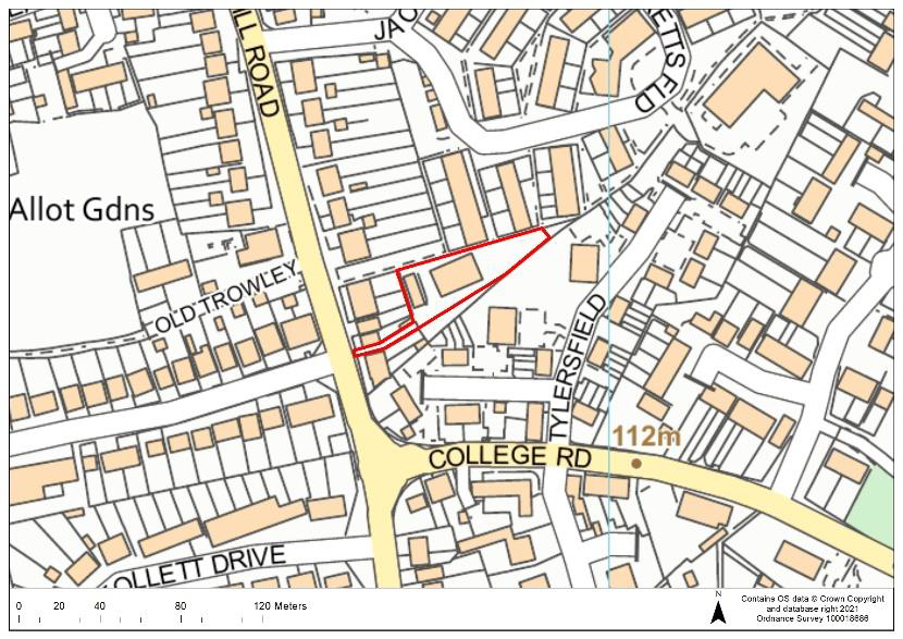 |
Current Use | Builder’s yard | |||
| Dwelling Capacity | 10 | ||||
| Green Belt | No | ||||
| Phasing | 6-10years | ||||
| Comments Any development would need to provide suitable mitigation to address surface water flood risk on areas of the site. |
|||||
Question 11 Do you agree that that Site AB32 is an appropriate development site? If not, please outline your reasons. |
AB39:
| Site Ref. | AB39 | Site | Garages, Rosehill Gardens, Abbots Langley | Size (ha): | 0.08 |
 |
Current Use | Garages | |||
| Dwelling Capacity | 6 | ||||
| Green Belt | No | ||||
| Phasing | 1-5 years | ||||
| Comments Any development would need take account of protected trees in/adjacent to the site and provide suitable mitigation to address surface water flood risk on areas of the site. |
|||||
Question 12 Do you agree that that Site AB39 is an appropriate development site? If not, please outline your reasons. |
2.13 The sites below are existing housing allocations in the Abbots Langley & Leavesden Area. These sites were allocated in the Site Allocations LDD (adopted 2014) but have not yet been built out. The sites will therefore be carried forward into the new Local Plan.
H3:
| Site Ref. | H3 | Site | Pin Wei, 35 High Street | Size (ha): | 0.13 |
 |
Current Use | Restaurant | |||
| Dwelling Capacity | 11 | ||||
| Green Belt | No | ||||
| Phasing | 6-10 years | ||||
| Comments The site is an existing housing allocation in the Site Allocations LDD (adopted 2014). |
|||||
H4:
| Site Ref. | H4 | Site | Furtherfield Depot, Furtherfield | Size (ha): | 0.53 |
 |
Current Use | Depot/storage | |||
| Dwelling Capacity | 36 | ||||
| Green Belt | No | ||||
| Phasing | 6-10 years | ||||
| Comments The site is an existing housing allocation in the Site Allocations LDD (adopted 2014). The area of public open space within the site boundary would require protection. The site would be required to provide open space and play space. |
|||||
H6:
| Site Ref. | H6 | Site | Hill Farm Industrial Estate, Leavesden | Size (ha): | 0.57 |
 |
Current Use | Industrial | |||
| Dwelling Capacity | 38 | ||||
| Green Belt | No | ||||
| Phasing | 6-10 years | ||||
| Comments The site is an existing housing allocation in the Site Allocations LDD (adopted 2014). The site would be required to provide open space and play space. |
|||||
BEDMOND
CFS10:
| Site Ref. | CFS10 | Site | Land between Millhouse Lane and Bell Lane, Bedmond | Size (ha): | 1.2 |
 |
Current Use | Open grassland | |||
| Dwelling Capacity | 34 | ||||
| Green Belt | Yes. If allocated, the Green Belt boundary would have to be revised. | ||||
| Phasing | 1-5 years | ||||
| Comments The site is proposed for specialised/supported housing for the elderly. A detailed heritage impact assessment and an archaeological assessment would be required prior to any development in order to protect and mitigate any potential adverse impacts to heritage assets. Any development would need take account of protected trees along the western boundary. Highway improvements to Bell Lane would also be required. The site would be required to provide open space (play-space not required as proposed for supported housing for the elderly). |
|||||
Question 13 Do you agree that that Site CFS10 is an appropriate development site? If not, please outline your reasons. |
CFS56:
| Site Ref. | CFS56 | Site | Church Hill Road, Bedmond | Size (ha): | 2.9 |
 |
Current Use | Grazing | |||
| Dwelling Capacity | 31 | ||||
| Green Belt | Yes. If allocated, the Green Belt boundary would have to be revised. | ||||
| Phasing | 1-5 years | ||||
| Comments A detailed heritage impact assessment and an archaeological assessment would be required prior to any development in order to protect and mitigate any potential adverse impacts to heritage assets. Any development would need to provide suitable mitigation to address surface water flood risk on areas of the site and would also need to take account of protected trees adjacent to and in the site and the public right of way which runs along the southern boundary. The site would be required to provide open space and play space. |
|||||
Question 14 Do you agree that that Site CFS56 is an appropriate development site? If not, please outline your reasons. |
ACFS9e:
| Site Ref. | ACFS9e | Site | Land west of Bedmond Road, Bedmond | Size (ha): | 1 |
 |
Current Use | Grazing | |||
| Dwelling Capacity | 48 | ||||
| Green Belt | Yes. If allocated, the Green Belt boundary would have to be revised. | ||||
| Phasing | 1-5 years | ||||
| Comments Any development would need to take account of protected trees within the site. The site would be required to provide open space and play space. |
|||||
Question 15 Do you agree that that Site ACFS9e is an appropriate development site? If not, please outline your reasons. |
GARSTON
CFS65:
| Site Ref. | CFS65 | Site | Land north of Bucknalls Lane, Garston | Size (ha): | 5.8 4.2 (accounting for 100m buffer) |
 |
Current Use | Former golf course | |||
| Dwelling Capacity | 190 | ||||
| Green Belt | Yes. If allocated, the Green Belt boundary would have to be revised. | ||||
| Phasing | 1-10 years | ||||
| Comments An archaeological assessment would be required prior to any development in order to protect and mitigate any potential adverse impacts to heritage assets of archaeological interest. Potential noise and air quality issues arising from the site’s proximity to the A405 and M1 would need to be addressed as part of any development. Any development would be required to take account of the presence of protected trees within the site. A minimum 100m buffer distance between the nearest dwellings and the boundary of the Waterdale Household Waste Recycling Centre (located to the north) would be required as part of any development, which would reduce the developable area to approximately 4.2ha. The site would be required to provide open space and play space. |
|||||
Question 16 Do you agree that that Site CFS65 is an appropriate development site? If not, please outline your reasons. |
KINGS LANGLEY
ACFS8b:
| Site Ref. | ACFS8b | Site | Flower house, 2-3 Station Road, Kings Langley | Size (ha): | 0.4 |
 |
Current Use | Retail | |||
| Dwelling Capacity | 19 | ||||
| Green Belt | Yes. If allocated, the Green Belt boundary would have to be revised. | ||||
| Phasing | 1-5 years | ||||
| Comments A detailed heritage impact assessment would be required prior to any development in order to protect and mitigate any potential adverse impacts to heritage assets. The western boundary of the site is in Flood Zone 3b due to the main river which along the western boundary of the site; no development would be permitted on this part of the site and an 8 metre buffer between Flood Zone 3b and any development would be required. Any development of the site would need to take account of the potential noise issues arising from the site’s proximity to the M25 and Kings Langley station as well as potential air quality issues due to proximity to the M25. |
|||||
Question 17 Do you agree that that Site ACFS8b is an appropriate development site? If not, please outline your reasons. |
PSCFS23:
| Site Ref. | PSCFS23 | Site | Former Chicken Processing Plant, Woodlands Road | Size (ha): | 1.3 |
 |
Current Use | Former poultry farm | |||
| Dwelling Capacity | 62 | ||||
| Green Belt | Yes. If allocated, the Green Belt boundary would have to be revised. | ||||
| Phasing | 1-5 years | ||||
| Comments A detailed heritage impact assessment and an archaeological assessment would be required prior to any development in order to protect and mitigate any potential adverse impacts to heritage assets. Any development would need take account of protected trees adjacent to/within the site as well as potential noise issues arising from the site’s proximity to the railway line. Proposals would also need to address the areas of the site at risk of surface water flooding and provide suitable mitigation as necessary. The site would be required to provide open space and play space. |
|||||
Question 18 Do you agree that that Site PSCFS23 is an appropriate development site? If not, please outline your reasons. |
CFS26c:
*This site (Site CFS26c) is also included in the Abbots Langley & Leavesden section*
| Site Ref. | CFS26c | Site | West of the Kings Langley Estate | Size (ha): | 25.5 |
 |
Current Use | Open land Agricultural |
|||
| Dwelling Capacity | 893 | ||||
| Green Belt | Yes. If allocated, the Green Belt boundary would have to be revised. | ||||
| Phasing | 6-15 years | ||||
| Comments Part of the site is designated as a Local Wildlife Site and measures to avoid adverse impacts and enhance biodiversity would need to be provided. Any development would also be required to take account of the presence of protected trees and public rights of way within the site as well as providing suitable mitigation to address surface water flood risk in areas of the site. There are Locally Listed Buildings to the west and south-west of the site and any development would need to protect and mitigate any potential adverse impacts to these heritage assets. Potential noise and air quality issues arising from the site’s proximity to the M25 would also need to be addressed. Upgrades to the wastewater network would likely be required if the site were to be developed. The site would be required to provide a primary school, open space and play space. |
|||||
Question 18a Do you agree that that Site CFS26c is an appropriate development site? If not, please outline your reasons. |
LANGLEYBURY
2.14 The site below is an existing housing allocation in the Langleybury area. This site was allocated in the Site Allocations LDD (adopted 2014) and is subject to the Langleybury and Grove Development Brief (2012) but has not yet been built out. The site will therefore be carried forward into the new Local Plan.
H7:
| Site Ref. | H7 | Site | Langleybury House/School | Size (ha): | 1.97 |
 |
Current Use | In use for filming, comprised of redundant school buildings | |||
| Dwelling Capacity | 25 | ||||
| Green Belt | The site would remain in the Green Belt and the redundant school buildings are proposed for replacement with housing. | ||||
| Phasing | 6-10 years | ||||
| Comments The site is an existing housing allocation in the Site Allocations LDD (adopted 2014) and part of the Langleybury and Grove Development Brief (2012) area. As set out in the Langleybury and Grove Development Brief, it is intended that a change in the location of the existing built footprint of the former secondary school buildings would be replaced with new development. Any development will be delivered in line with the Langleybury and Grove Development Brief. The site would be required to provide open space and play space. The site is subject to a planning application which is pending consideration for the temporary change of use of the site to film studios for three years (20/1697/RSP). |
|||||
CROXLEY GREEN
CFS19:
| Site Ref. | CFS19 | Site | Land adjacent 62-84 & 99-121 Sycamore Road | Size (ha): | 0.27 |
 |
Current Use | Amenity grassland | |||
| Dwelling Capacity | 17 | ||||
| Green Belt | No | ||||
| Phasing | 1-5 years | ||||
| Comments Any development would also be required to provide suitable mitigation to address surface water flood risk and groundwater flood risk on areas of the site. The site is in Groundwater Source Protection Zone 1; a preliminary risk assessment to determine whether there is contamination of the site, and whether remediation works would be needed, would be required at the pre-application stage to support any proposals on the site. Any development would need to take account of the presence of the protected trees in/adjacent to the site. The site is subject to a planning application for nine dwellings which is pending consideration (20/2737/FUL). |
|||||
Question 19 Do you agree that that Site CFS19 is an appropriate development site? If not, please outline your reasons. |
CFS20:
| Site Ref. | CFS20 | Site | Land at Croxley Station, Watford Road | Size (ha): | 2.3 |
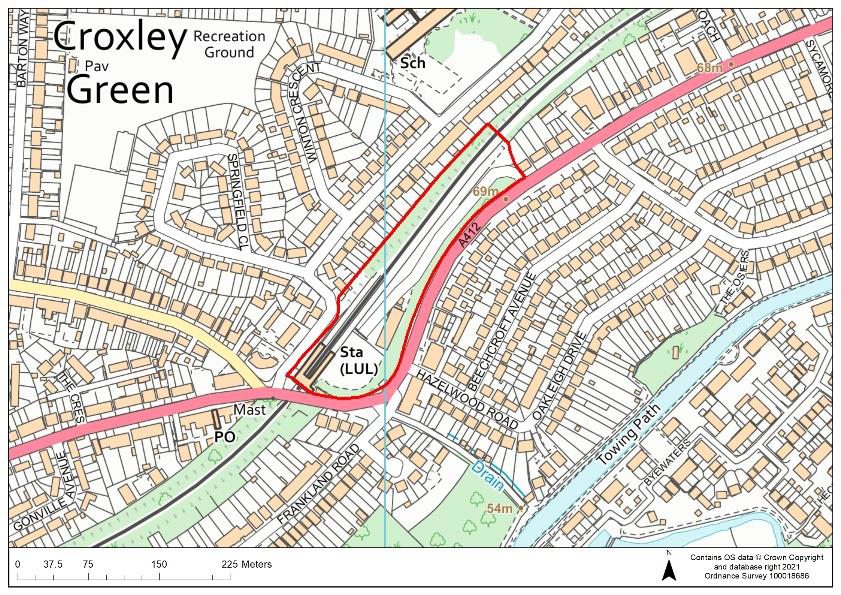 |
Current Use | Station, station car park & timber yard | |||
| Dwelling Capacity | 163 | ||||
| Green Belt | No | ||||
| Phasing | 11-15 years | ||||
| Comments The southern area of the site is an existing housing allocation in the Site Allocations LDD (adopted 2014) (Site H13). Any development would be required to provide suitable mitigation to address surface water flood risk. The site is in Groundwater Source Protection Zone 1; a preliminary risk assessment to determine whether there is contamination of the site, and whether remediation works would be needed, would be required at the pre-application stage to support any proposals on the site. Potential noise and vibrations caused by the use of the station/railway line would need to be addressed through mitigation measures. The site would be required to provide open space and play space. The station use would remain as part of any development and proposals would need to safeguard parking provision for the station. |
|||||
Question 20 Do you agree that that Site CFS20 is an appropriate development site? If not, please outline your reasons. |
CFS61:
| Site Ref. | CFS61 | Site | Cinnamond House, Cassiobridge | Size (ha): | 1 |
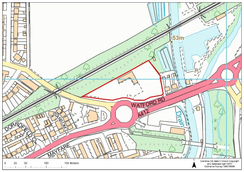 |
Current Use | Office, workshop and parking | |||
| Dwelling Capacity | 133 | ||||
| Green Belt | Yes. If allocated, the Green Belt boundary would have to be revised | ||||
| Phasing | 1-10 years | ||||
| Comments Any development would be required to provide suitable mitigation to address surface water flood risk and groundwater flood risk on the site. The site is in Groundwater Source Protection Zone 1; a preliminary risk assessment to determine whether there is contamination of the site, and whether remediation works would be needed, would be required at the pre-application stage to support any proposals on the site. A detailed heritage impact assessment and an archaeological assessment would be required prior to any development in order to protect and mitigate any potential adverse impacts to heritage assets. Potential noise and vibrations caused by the use of the railway line should be addressed through mitigation measures. The site would be required to provide open space and play space. |
|||||
Question 21 Do you agree that that Site CFS61 is an appropriate development site? If not, please outline your reasons. |
CG16:
| Site Ref. | CG16 | Site | Garages, Owen’s Way, Croxley Green | Size (ha): | 0.09 |
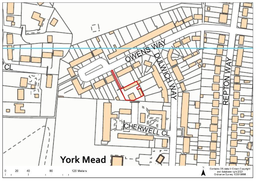 |
Current Use | Garages | |||
| Dwelling Capacity | 6 | ||||
| Green Belt | No | ||||
| Phasing | 11-15 years | ||||
| Comments Any development would need to provide suitable mitigation to address surface water flood risk on areas of the site and suitable access arrangements would need to be achieved. |
|||||
Question 22 Do you agree that that Site CG16 is an appropriate development site? If not, please outline your reasons. |
CG47:
| Site Ref. | CG47 | Site | Garages off Grove Crescent | Size (ha): | 0.26 |
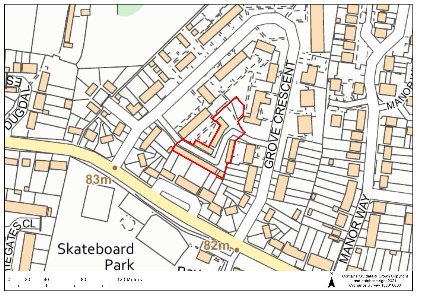 |
Current Use | Garages | |||
| Dwelling Capacity | 19 | ||||
| Green Belt | No | ||||
| Phasing | 11-15 years | ||||
| Comments Any development would need to provide suitable mitigation to address surface water flood risk on areas of the site. The site would be required to provide open space and play space. |
|||||
Question 23 Do you agree that that Site CG47 is an appropriate development site? If not, please outline your reasons. |
CG65:
| Site Ref. | CG65 | Site | British Red Cross, Community Way | Size (ha): | 0.06 |
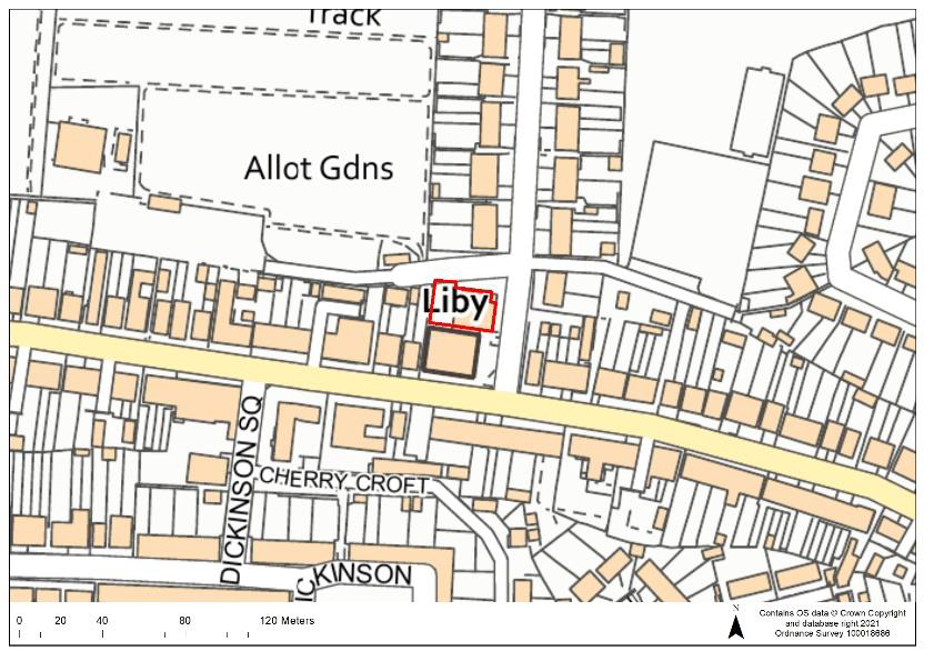 |
Current Use | British Red Cross building & ancillary car park | |||
| Dwelling Capacity | 6 | ||||
| Green Belt | No | ||||
| Phasing | 11-15 years | ||||
| Comments Any development would need to provide suitable mitigation to address surface water flood risk on areas of the site. A detailed heritage impact assessment may be required prior to any development. The public right of way running along the northern boundary would need to be protected. Re-provision of the community facility would be required on-site. |
|||||
Question 24 Do you agree that that Site CG65 is an appropriate development site? If not, please outline your reasons. |
2.15 The sites below are existing housing allocations in the Croxley Green area. These sites were allocated in the Site Allocations LDD (adopted 2014) but have not yet been built out. The sites will therefore be carried forward into the new Local Plan.
H9:
| Site Ref. | H9 | Site | 33 Baldwins Lane, Croxley Green | Size (ha): | 0.9 |
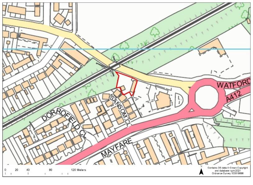 |
Current Use | Car sales centre | |||
| Dwelling Capacity | 59 | ||||
| Green Belt | No | ||||
| Phasing | 6-10 years | ||||
| Comments The site is an existing housing allocation in the Site Allocations LDD (adopted in 2014). Any development would be required to provide suitable mitigation to address surface water flood risk and groundwater flood risk on the site. The site is in Groundwater Source Protection Zone 1; a preliminary risk assessment to determine whether there is contamination of the site, and whether remediation works would be needed, would be required at the pre-application stage to support any proposals on the site. Potential noise and vibrations caused by the use of the railway line should be addressed through mitigation measures. The site would be required to provide open space and play space. |
|||||
H10:
| Site Ref. | H10 | Site | Killingdown Farm, Croxley Green | Size (ha): | 7.6 |
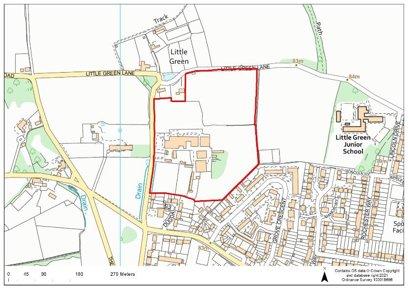 |
Current Use | Agricultural | |||
| Dwelling Capacity | 267 | ||||
| Green Belt | No | ||||
| Phasing | 1-10 years | ||||
| Comments The site is an existing housing allocation in the Site Allocations LDD (adopted in 2014). Any development would be required to provide suitable mitigation to address surface water flood risk on the site and a detailed heritage impact assessment would be required prior to any development in order to protect and mitigate any potential adverse impacts to heritage assets. The site would be required to provide open space and play space. The site is subject to a planning application for 160 dwellings that is pending consideration (20/1881/FUL).. |
|||||
RICKMANSWORTH
OSPF22:
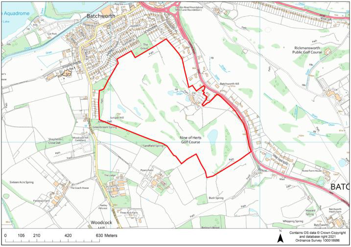
| Site Ref. | OSPF22 | Site | Batchworth Golf Course | Size (ha): | 49.4 (whole site) 17.5 (developable area) |
 |
Current Use | Golf Course | |||
| Dwelling Capacity | 618 | ||||
| Green Belt | Yes. If allocated, the Green Belt boundary would have to be revised | ||||
| Phasing | 6-15 years | ||||
| Comments Any development would be required to provide suitable mitigation to address surface water flood risk on the site. An area to the north of the site is Groundwater Source Protection Zone 1; a preliminary risk assessment to determine whether there is contamination of the site, and whether remediation works would be needed, would be required at the pre-application stage to support any proposals on the site. A detailed heritage impact assessment would be required prior to any development in order to protect and mitigate any potential adverse impacts to heritage assets. Development would also need to account of protected trees in the site as well as addressing any potential contamination due to the area of historic landfill within the site. The site would be required to provide a primary school, open space and play space. |
|||||
Question 25 Do you agree that that Site OSPF22 is an appropriate development site? If not, please outline your reasons. |
Indicative Masterplan (OSPF22):
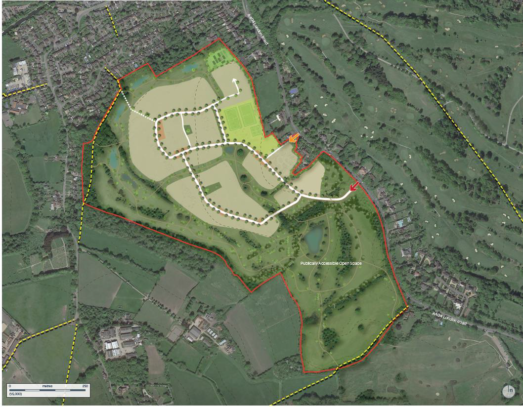
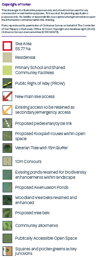
2.16 The following masterplan provides an indication of the quantum of housing, layout and infrastructure provision that could be supported on the site however the final detailed masterplan will be decided at the planning application stage should the site be allocated for housing. We are not seeking comments on the indicative masterplan and it is for illustrative purposes only.
CFS40a:
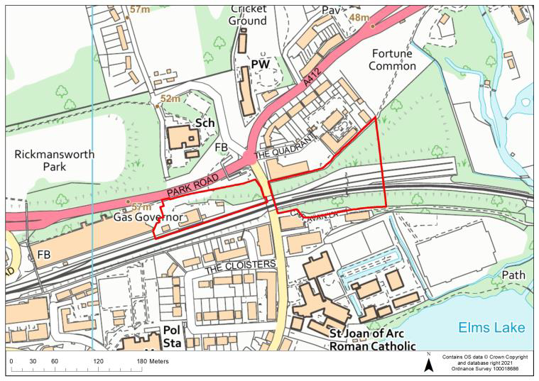
| Site Ref. | CFS40a | Site | Land at Park Road, Rickmansworth | Size (ha): | 1.8 |
 |
Current Use | Transport for London depot and car park, grassland/tree coverage | |||
| Dwelling Capacity | 112 | ||||
| Green Belt | No | ||||
| Phasing | 11-15 years | ||||
| Comments Any development would be required to provide suitable mitigation to address surface water flood risk and groundwater flood risk in the site. The site is in Groundwater Source Protection Zone 1; a preliminary risk assessment to determine whether there is contamination of the site, and whether remediation works would be needed, would be required at the pre-application stage to support any proposals on the site. A detailed heritage impact assessment and an archaeological assessment would be required prior to any development in order to protect and mitigate any potential adverse impacts to heritage assets. Potential noise and vibrations caused by the use of the railway line should be addressed through mitigation measures. Development would also need to account of protected trees in the site. The site would be required to provide open space and play space. |
|||||
Question 26 Do you agree that that Site CFS40a is an appropriate development site? If not, please outline your reasons. |
CFS41:
| Site Ref. | CFS41 | Site | Rickmansworth Station, Station Approach | Size (ha): | 0.9 |
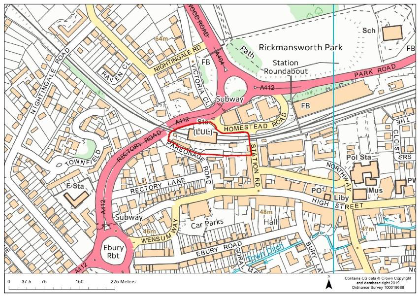 |
Current Use | Rickmansworth station, adjoining car park and vacant land | |||
| Dwelling Capacity | 70 | ||||
| Green Belt | No | ||||
| Phasing | 11-15 years | ||||
| Comments Any development would be required to provide suitable mitigation to address surface water flood risk on the site. The site is in Groundwater Source Protection Zone 1; a preliminary risk assessment to determine whether there is contamination of the site, and whether remediation works would be needed, would be required at the pre-application stage to support any proposals on the site. Potential noise and vibrations caused by the use of the station/railway line should be addressed through mitigation measures. Development would also need to account for protected trees on the site and a detailed heritage impact assessment would be required prior to any development in order to protect and mitigate any potential adverse impacts to heritage assets. The site would be required to provide open space and play space. The station use would remain as part of any development and proposals would need to safeguard parking provision for the station. |
|||||
Question 27 Do you agree that that Site CFS41 is an appropriate development site? If not, please outline your reasons. |
CFS59:
| Site Ref. | CFS59 | Site | Land on London Road | Size (ha): | 1.1 |
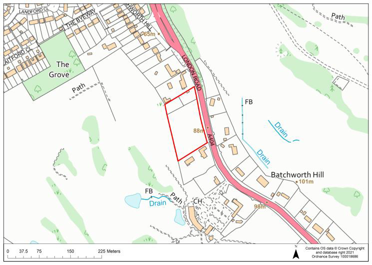 |
Current Use | Open grassland | |||
| Dwelling Capacity | 75 C2 bedrooms (equivalent to 40 dwellings) | ||||
| Green Belt | Yes. If allocated, the Green Belt boundary would have to be revised. | ||||
| Phasing | 1-5 years | ||||
| Comments The site is proposed for the provision of a residential care home (C2 Use Class). The site is in Groundwater Source Protection Zone 1; a preliminary risk assessment to determine whether there is contamination of the site, and whether remediation works would be needed, would be required at the pre-application stage to support any proposals on the site. The site would be required to provide open space. |
|||||
Question 28 Do you agree that that Site CFS59 is an appropriate development site? If not, please outline your reasons. |
CFS60
| Site Ref. | CFS60 | Site | Affinity Water Depot, Church Street | Size (ha): | 1.5 |
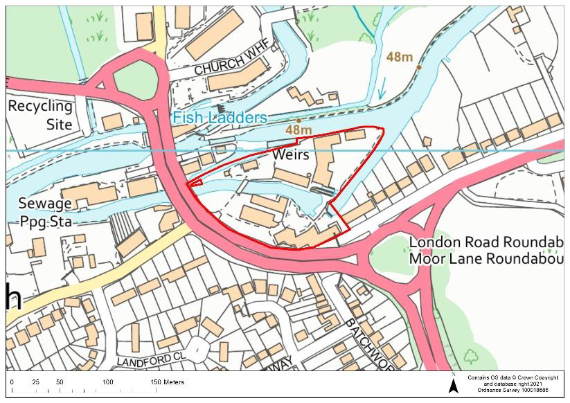 |
Current Use | Affinity Water offices (former), water abstraction & treatment facilities | |||
| Dwelling Capacity | 65 | ||||
| Green Belt | No | ||||
| Phasing | 1-10 years | ||||
| Comments The majority of the site is in Flood Zone 3a and approximately half of the site is in Flood Zone 3b; no new residential development will be permitted on Flood Zone 3b within the site and it is proposed that across the whole site, residential development will be delivered through the conversion of existing buildings only. Suitable mitigation to address surface water flood risk and groundwater flood risk on the site would also be required. The site is in Groundwater Source Protection Zone 1; a preliminary risk assessment to determine whether there is contamination of the site, and whether remediation works would be needed, would be required at the pre-application stage to support any proposals on the site. A detailed heritage impact assessment would also be required prior to any development in order to protect and mitigate any potential adverse impacts to heritage assets and the Locally Listed Buildings in the site would require protection. Affinity Water have stated that water treatment uses would remain on the site. The site would be required to provide open space and play space. |
|||||
Question 29 Do you agree that that Site CFS60 is an appropriate development site? If not, please outline your reasons |
CFS77:
| Site Ref. | CFS77 | Site | Rickmansworth Library | Size (ha): | 0.1 |
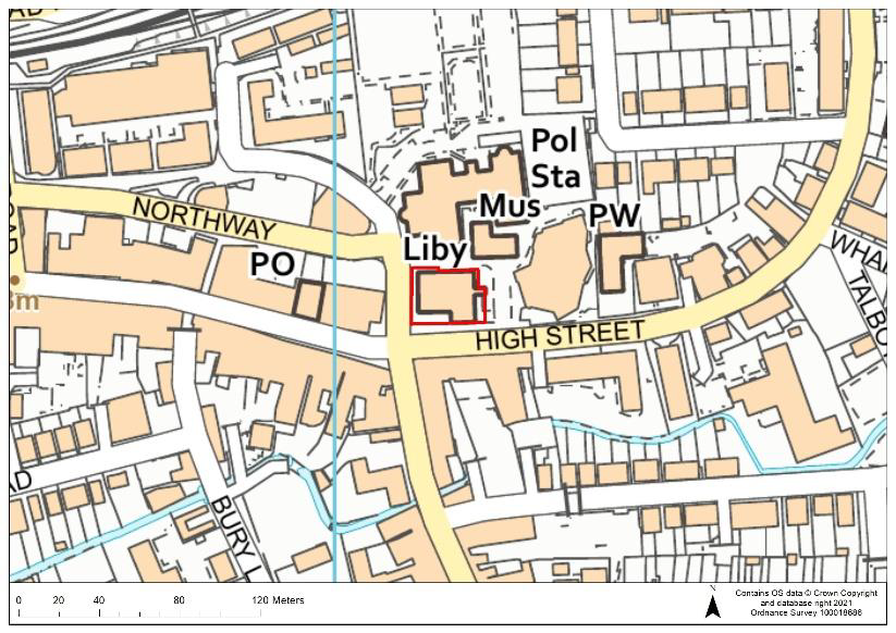 |
Current Use | Library | |||
| Dwelling Capacity | 7 | ||||
| Green Belt | No | ||||
| Phasing | 11-15years | ||||
| Comments Redevelopment of the site would require the re-provision of the library facility in a suitable, accessible location. A modern, upgraded library with improved facilities and access is potentially proposed for provision in the adjacent Council Offices. There is potential for a commercial use on the ground-floor of the redeveloped site. Suitable mitigation to address surface water flood risk and groundwater flood risk on the site would be required. The site is in Groundwater Source Protection Zone 1 so a preliminary risk assessment to determine whether there is contamination of the site, and whether remediation works would be needed, would be required at the pre-application stage to support any proposals on the site. A detailed heritage impact assessment and archaeological assessment would also be required prior to any development in order to protect and mitigate any potential adverse impacts to heritage assets. |
|||||
Question 30 Do you agree that that Site CFS77 is an appropriate development site? If not, please outline your reasons. |
RWA13:
| Site Ref. | RWA13 | Site | Banstead Down, Old Chorleywood Road | Size (ha): | 0.3 |
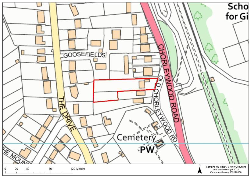 |
Current Use | Residential gardens and residential dwelling | |||
| Dwelling Capacity | 12 | ||||
| Green Belt | No | ||||
| Phasing | 1-5 years | ||||
| Comments The site is in Groundwater Source Protection Zone 1; a preliminary risk assessment to determine whether there is contamination of the site, and whether remediation works would be needed, would be required at the pre-application stage to support any proposals on the site. Development would need to account for protected trees on the site and it is proposed that the existing residential dwelling to the east would be retained. |
|||||
Question 31 Do you agree that that Site RWA13 is an appropriate development site? If not, please outline your reasons. |
2.17 The sites below are existing housing allocations in the Rickmansworth area. These sites were allocated in the Site Allocations LDD (adopted 2014) but have not yet been built out. The sites will therefore be carried forward into the new Local Plan.
H17:
| Site Ref. | H17 | Site | Police Station, Rectory Road | Size (ha): | 0.29 |
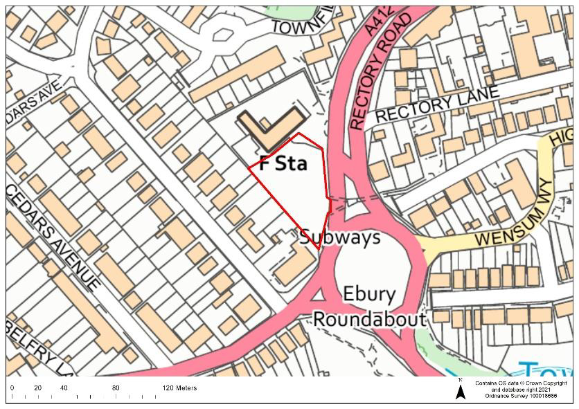 |
Current Use | Former police station | |||
| Dwelling Capacity | 24 | ||||
| Green Belt | No | ||||
| Phasing | 6-10 years | ||||
| Comments The site is an existing housing allocation in the Site Allocations LDD (adopted 2014). Suitable mitigation to address surface water flood risk and groundwater flood risk on the site would be required. The site is in Groundwater Source Protection Zone 1; a preliminary risk assessment to determine whether there is contamination of the site, and whether remediation works would be needed, would be required at the pre-application stage to support any proposals on the site. A detailed heritage impact assessment would also be required prior to any development in order to protect and mitigate any potential adverse impacts to heritage assets. The site would be required to provide open space and play space. |
|||||
H18:
| Site Ref. | H18 | Site | Royal British Legion, Ebury Road | Size (ha): | 0.08 |
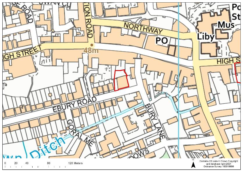 |
Current Use | Royal British Legion hall | |||
| Dwelling Capacity | 6 | ||||
| Green Belt | No | ||||
| Phasing | 6-10 years | ||||
| Comments The site is an existing housing allocation in the Site Allocations LDD (adopted 2014). Suitable mitigation to address groundwater flood risk on the site would be required. The site is in Groundwater Source Protection Zone 1; a preliminary risk assessment to determine whether there is contamination of the site, and whether remediation works would be needed, would be required at the pre-application stage to support any proposals on the site. A detailed heritage impact assessment would also be required prior to any development in order to protect and mitigate any potential adverse impacts to heritage assets. |
|||||
H21:
| Site Ref. | H21 | Site | Bridge Motors, Church Street | Size (ha): | 0.12 |
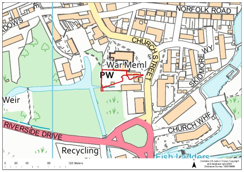 |
Current Use | Garage & car sales centre | |||
| Dwelling Capacity | 39 | ||||
| Green Belt | No | ||||
| Phasing | 1-5 years | ||||
| Comments The site is an existing housing allocation in the Site Allocations LDD (adopted 2014). Suitable mitigation to address groundwater flood risk on the site would be required. The site is in Groundwater Source Protection Zone 1; a preliminary risk assessment to determine whether there is contamination of the site, and whether remediation works would be needed, would be required at the pre-application stage to support any proposals on the site. A detailed heritage impact assessment would also be required prior to any development in order to protect and mitigate any potential adverse impacts to heritage assets. |
|||||
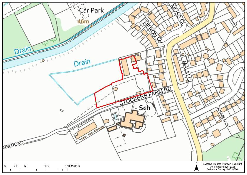
H22:
| Site Ref. | H22 | Site | Depot, Stockers Farm Road | Size (ha): | 0.8 |
 |
Current Use | Affinity Water depot | |||
| Dwelling Capacity | 60 | ||||
| Green Belt | No | ||||
| Phasing | 1-5 years | ||||
| Comments The site is an existing housing allocation in the Site Allocations LDD (adopted 2014). Suitable mitigation to address surface water flood risk and groundwater flood risk on the site would be required. A detailed heritage impact assessment would also be required prior to any development in order to protect and mitigate any potential adverse impacts to heritage assets. The public right of way running through the south-western part of the site would require protection. Part of the site, to the west, is located in a Local Wildlife Site, with the Local Wildlife Site also located adjacent to the north and east of the site; measures to avoid adverse impacts and enhance biodiversity would need to be provided. The site would be required to provide open space and play space. |
|||||
MILL END
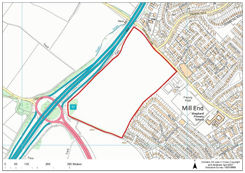
EOS7.0:
| Site Ref. | EOS7.0: | Site | Land to the south of Shepherds Lane and west of the M25 | Size (ha): | 20.8 |
 |
Current Use | Agricultural | |||
| Dwelling Capacity | 760 | ||||
| Green Belt | Yes. If allocated, the Green Belt boundary would have to be revised. | ||||
| Phasing | 6-15 years | ||||
| Comments An archaeological assessment would be required prior to any development in order to protect and mitigate any potential adverse impacts to heritage assets of archaeological interest. Potential noise and air quality issues arising from the site’s proximity to the M25 would need to be addressed as part of any development. Development would need to take account of protected trees in the site and the public right of way adjacent to the site. Suitable mitigation to address surface water flood risk and groundwater flood risk on the site would also be required. The site is in Groundwater Source Protection Zone 1; a preliminary risk assessment to determine whether there is contamination of the site, and whether remediation works would be needed, would be required at the pre-application stage to support any proposals on the site. The site would be required to provide a primary school, open space and play space. Strategic drainage infrastructure is likely to be required to ensure sufficient capacity prior to development of the site. |
|||||
Question 32 Do you agree that that Site EOS7.0 is an appropriate development site? If not, please outline your reasons. |
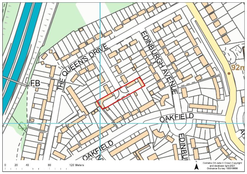
P4a:
| Site Ref. | P4a | Site | Quickwood Close Garages, Mill End | Size (ha): | 0.16 |
 |
Current Use | Garages | |||
| Dwelling Capacity | 7 | ||||
| Green Belt | No | ||||
| Phasing | 11-15 years | ||||
| Comments Suitable mitigation to address surface water flood risk on the site would be required. The site is in Groundwater Source Protection Zone 1; a preliminary risk assessment to determine whether there is contamination of the site, and whether remediation works would be needed, would be required at the pre-application stage to support any proposals on the site. |
|||||
Question 33 Do you agree that that Site P4a is an appropriate development site? If not, please outline your reasons. |
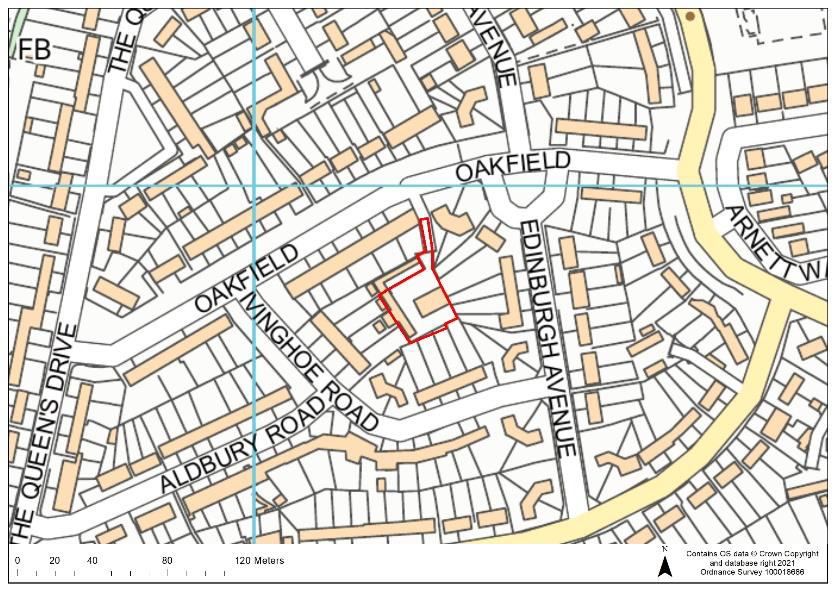
P7:
| Site Ref. | P7 | Site | Oakfield Garages, Oakfield, Mill End | Size (ha): | 0.1 |
 |
Current Use | Garages | |||
| Dwelling Capacity | 6 | ||||
| Green Belt | No | ||||
| Phasing | 11-15 years | ||||
| Comments The site is in Groundwater Source Protection Zone 1; a preliminary risk assessment to determine whether there is contamination of the site, and whether remediation works would be needed, would be required at the pre-application stage to support any proposals on the site. |
|||||
Question 34 Do you agree that that Site P7 is an appropriate development site? If not, please outline your reasons. |
P33:
| Site Ref. | P33 | Site | Chiltern Drive Garages | Size (ha): | 0.07 |
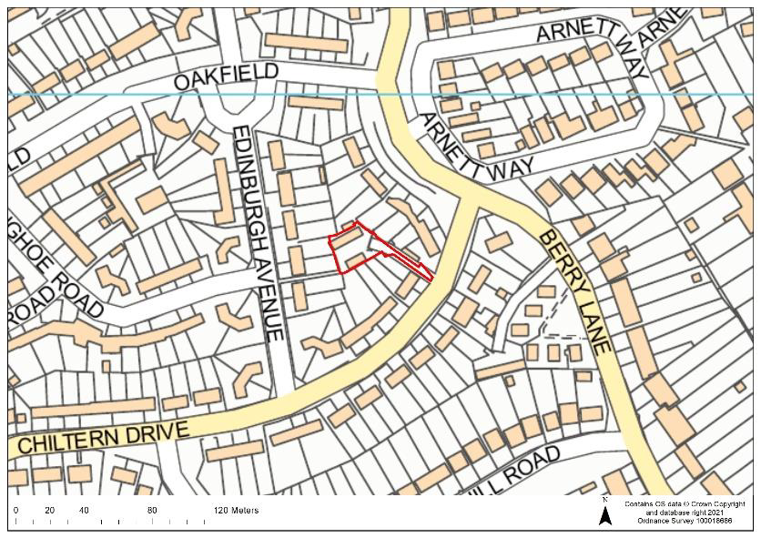 |
Current Use | Garages | |||
| Dwelling Capacity | 6 | ||||
| Green Belt | No | ||||
| Phasing | 11-15 years | ||||
| Comments The site is in Groundwater Source Protection Zone 1; a preliminary risk assessment to determine whether there is contamination of the site, and whether remediation works would be needed, would be required at the pre-application stage to support any proposals on the site.. |
|||||
Question 35 Do you agree that that Site P33 is an appropriate development site? If not, please outline your reasons. |
P38:
| Site Ref. | P38 | Site | Garages at Whitfield Way, Mill End | Size (ha): | 0.09 |
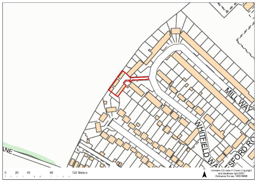 |
Current Use | Garages | |||
| Dwelling Capacity | 6 | ||||
| Green Belt | No | ||||
| Phasing | 11-15 years | ||||
Comments The site is in Groundwater Source Protection Zone 1; a preliminary risk assessment to determine whether there is contamination of the site, and whether remediation works would be needed, would be required at the pre-application stage to support any proposals on the site. |
|||||
Question 36 Do you agree that that Site P38 is an appropriate development site? If not, please outline your reasons. |
P39
| Site Ref. | P39 | Site | The Queens Drive Garages, Mill End | Size (ha): | 0.11 |
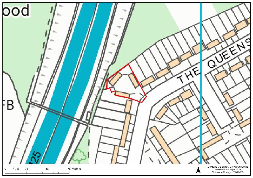 |
Current Use | Garages | |||
| Dwelling Capacity | 7 | ||||
| Green Belt | No | ||||
| Phasing | 1-5 years | ||||
| Comments The site is in Groundwater Source Protection Zone 1; a preliminary risk assessment to determine whether there is contamination of the site, and whether remediation works would be needed, would be required at the pre-application stage to support any proposals on the site. Potential noise and air quality issues arising from the site’s proximity to the M25 would need to be addressed as part of any development. |
|||||
Question 37 Do you agree that that Site P39 is an appropriate development site? If not, please outline your reasons. |
RW31
| Site Ref. | RW31 | Site | Garden land off Uxbridge Road, Mill End | Size (ha): | 0.17 |
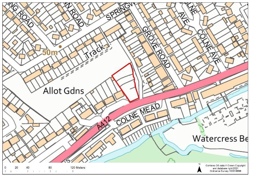 |
Current Use | Garden Land | |||
| Dwelling Capacity | 12 | ||||
| Green Belt | No | ||||
| Phasing | 11-15 years | ||||
| Comments Suitable mitigation to address surface water flood risk and groundwater flood risk on the site would be required. The site is in Groundwater Source Protection Zone 1; a preliminary risk assessment to determine whether there is contamination of the site, and whether remediation works would be needed, would be required at the pre-application stage to support any proposals on the site. |
|||||
Question 38 Do you agree that that Site RW31 is an appropriate development site? If not, please outline your reasons. |
2.18 The sites below are existing housing allocations in the Mill End area. These sites were allocated in the Site Allocations LDD (adopted 2014) but have not yet been built out. The sites will therefore be carried forward into the new Local Plan.
H15:
| Site Ref. | H15: | Site | Garages rear of Drillyard, West Way | Size (ha): | 0.22 |
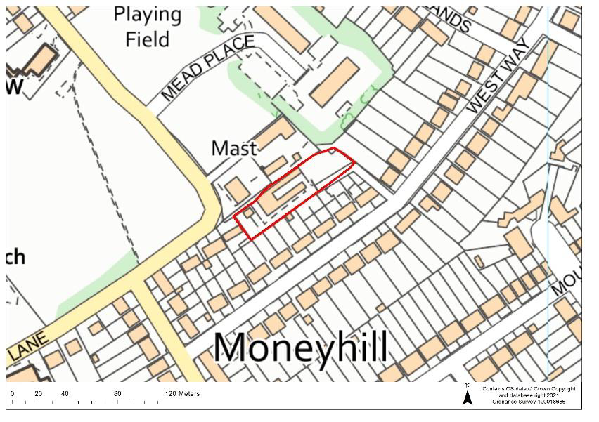 |
Current Use | Garages | |||
| Dwelling Capacity | 13 | ||||
| Green Belt | No | ||||
| Phasing | 1-5 years | ||||
| Comments The site is an existing housing allocation in the Site Allocations LDD (adopted 2014). Any development would need to take account of protected trees within and adjacent to the site. |
|||||
CHORLEYWOOD
CFS16:
| Site Ref. | CFS16: | Site | Land at Chorleywood Station (station car park and adjoining land) | Size (ha): | 2.3 |
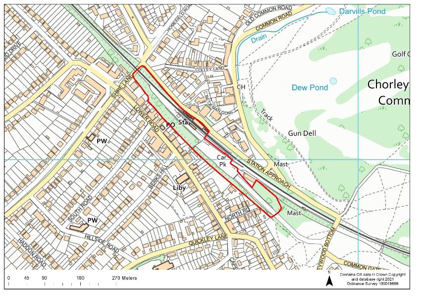 |
Current Use | Chorleywood station, car park and adjoining land | |||
| Dwelling Capacity | 190 | ||||
| Green Belt | No | ||||
| Phasing | 11-15 years | ||||
| Comments A detailed heritage impact assessment would be required prior to any development in order to protect and mitigate any potential adverse impacts to heritage assets. Any proposals would need to take account of protected trees within the site as well as providing suitable mitigation to address surface water flood risk in areas of the site. Potential noise and vibrations caused by the use of the station/railway line should be addressed through mitigation measures. Upgrades to the wastewater network would likely be required if the site were to be developed. The site would be required to provide open space and play space. The station use would remain as part of any development and proposals would need to safeguard parking provision for the station. |
|||||
Question 39 Do you agree that that Site CFS16 is an appropriate development site? If not, please outline your reasons. |
CFS18b:
| Site Ref. | CFS18b | Site | Hill Farm, Stag Lane | Size (ha): | 27 |
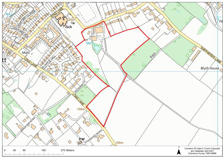 |
Current Use | Agricultural | |||
| Dwelling Capacity | 228 | ||||
| Green Belt | Yes. If allocated, the Green Belt boundary would have to be revised | ||||
| Phasing | 1-10 years | ||||
| Comments An archaeological assessment and detailed heritage impact assessment would be required prior to any development in order to protect and mitigate any potential adverse impacts to heritage assets. Any proposals would need to take account of protected trees and public rights of way within the site as well as providing suitable mitigation to address surface water flood risk in areas of the site. Upgrades to the wastewater network would likely be required if the site were to be developed. The site would be required to provide open space and play space. |
|||||
Question 40 Do you agree that that Site CFS18b is an appropriate development site? If not, please outline your reasons. |
CFS57:
| Site Ref. | CFS57 | Site | Pheasants Ridge Gap, Berry Lane | Size (ha): | 0.7 |
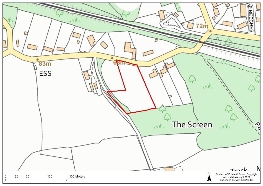 |
Current Use | Paddock | |||
| Dwelling Capacity | 40 | ||||
| Green Belt | Yes. If allocated, the Green Belt boundary would have to be revised. | ||||
| Phasing | 6-10 years | ||||
| Comments Part of the site is in Groundwater Source Protection Zone 1; a preliminary risk assessment to determine whether there is contamination of the site, and whether remediation works would be needed, would be required at the pre-application stage to support any proposals on the site. A detailed heritage impact assessment would be required prior to any development in order to protect and mitigate any potential adverse impacts to heritage assets and potential noise and air quality issues arising from the site’s proximity to the M25 would also need to be addressed. Any proposals would need to take account of protected trees adjacent within the site and provide suitable mitigation to address surface water flood risk in areas of the site. The site is adjacent to a Local Wildlife Site and measures to avoid adverse impacts and enhance biodiversity would need to be provided. The site would be required to provide open space and play space. |
|||||
Question 41 Do you agree that that Site CFS57 is an appropriate development site? If not, please outline your reasons. |
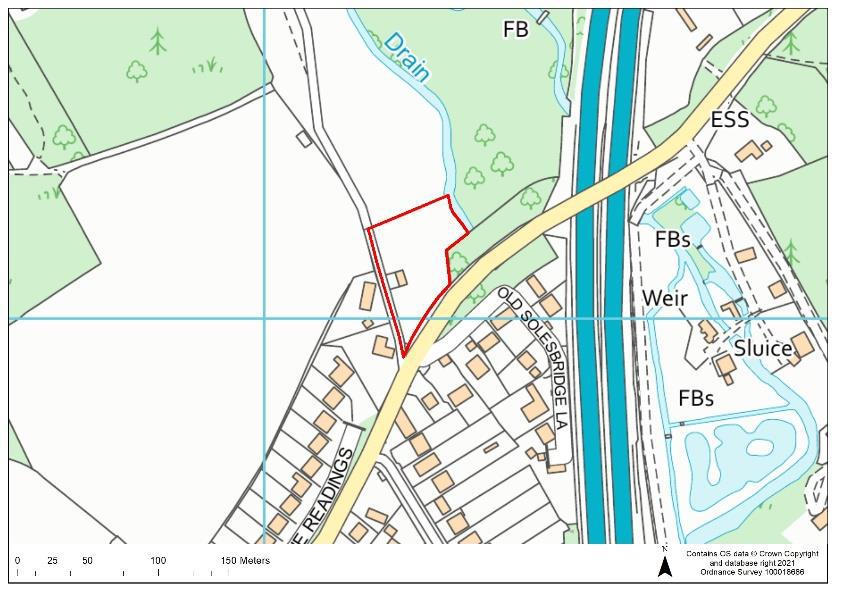
CFS72:
| Site Ref. | CFS72 | Site | Land off Solesbridge Lane, Chorleywood | Size (ha): | 0.4 |
 |
Current Use | Open land & barn | |||
| Dwelling Capacity | 19 | ||||
| Green Belt | Yes. If allocated, the Green Belt boundary would have to be revised. | ||||
| Phasing | 1-5 years | ||||
| Comments Part of the site is in Flood Zone 3b and there is an ordinary watercourse adjacent to the east of the site; a minimum 5 metre buffer between the ordinary watercourse and residential development would be required and no development would be permitted on the area of the site that is in Flood Zone 3b. Suitable mitigation to address surface water flood risk and groundwater flood risk in areas of the site would also be required and any proposals would need to take account of the public right of way adjacent to the site. A detailed heritage impact assessment would also be required prior to any development in order to protect and to mitigate any potential adverse impacts to heritage assets. The site is in close proximity to the Chorleywood NO2 AQMA; potential air quality issues and noise issues arising from the site’s proximity to the AQMA and M25 would also need to be addressed. |
|||||
Question 42 Do you agree that that Site CFS72 is an appropriate development site? If not, please outline your reasons. |
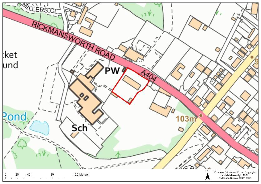
ACFS1:
| Site Ref. | ACFS1 | Site | Heath House, Chorleywood | Size (ha): | 0.2 |
 |
Current Use | Residential dwelling and garden | |||
| Dwelling Capacity | 10 | ||||
| Green Belt | Yes. If allocated, the Green Belt boundary would have to be revised. | ||||
| Phasing | 1-5 years | ||||
| Comments A detailed heritage impact assessment would be required prior to any development in order to protect and mitigate any potential adverse impacts to heritage assets. Any proposals would need to provide suitable mitigation to address surface water flood risk on areas of the site. |
|||||
Question 43 Do you agree that that Site ACFS1 is an appropriate development site? If not, please outline your reasons. |
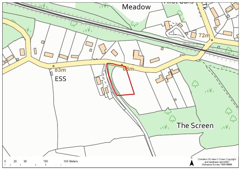
PSCFS19:
| Site Ref. | PSCFS19 | Site | Land south west of Berry Lane, Chorleywood | Size (ha): | 0.35 |
 |
Current Use | Grazing | |||
| Dwelling Capacity | 15 | ||||
| Green Belt | Yes. If allocated, the Green Belt boundary would have to be revised. | ||||
| Phasing | 1-5 years | ||||
| Comments A detailed heritage impact assessment and archaeological assessment would be required prior to any development in order to protect and mitigate any potential adverse impacts to heritage assets. Any development would need mitigate potential noise issues arising from the site’s proximity to the railway line and M25. The site is located in close proximity to the Chorleywood NO2 AQMA and potential air quality issues would also need to be addressed. Any proposals would need to provide suitable mitigation to address surface water flood risk on areas of the site and take account of protected trees along the southern boundary. |
|||||
Question 44 Do you agree that that Site PSCFS19 is an appropriate development site? If not, please outline your reasons. |
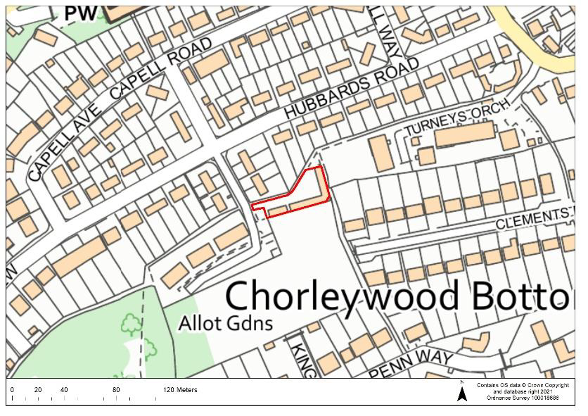
CW9:
| Site Ref. | CW9 | Site | Garages, Copmans Wick, Chorleywood | Size (ha): | 0.1 |
 |
Current Use | Garages | |||
| Dwelling Capacity | 6 | ||||
| Green Belt | No | ||||
| Phasing | 11-15 years | ||||
| Comments Any proposals would need to provide suitable mitigation to address surface water flood risk on areas of the site and ensure protection of the public right of way adjacent to the north of the site. |
|||||
Question 45 Do you agree that that Site CW9 is an appropriate development site? If not, please outline your reasons. |
CW24:
| Site Ref. | CW24 | Site | Garages, Green Street, Chorleywood | Size (ha): | 0.1 |
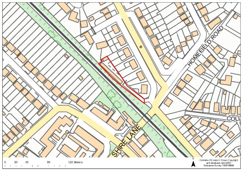 |
Current Use | Garages | |||
| Dwelling Capacity | 7 | ||||
| Green Belt | No | ||||
| Phasing | 1-5 years | ||||
| Comments Comments Any proposals would need to provide suitable mitigation to address surface water flood risk on areas of the site and mitigate potential noise issues arising from the site’s proximity to the railway line. |
|||||
Question 46 Do you agree that that Site CW24 is an appropriate development site? If not, please outline your reasons. |
CW25:
| Site Ref. | CW25 | Site | Garages, Green Street, Chorleywood | Size (ha): | 0.1 |
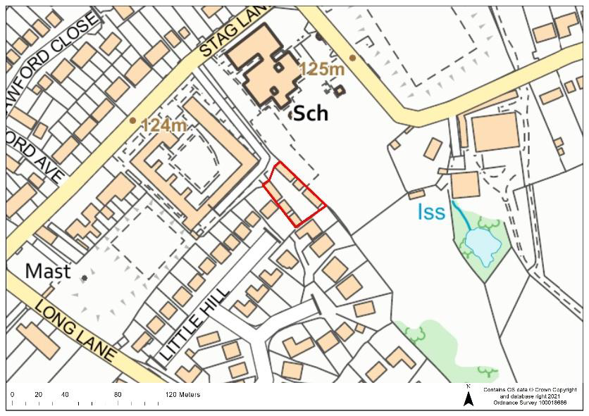 |
Current Use | Garages | |||
| Dwelling Capacity | 7 | ||||
| Green Belt | No | ||||
| Phasing | 11-15 years | ||||
| Comments A detailed heritage impact assessment and archaeological assessment would be required prior to any development in order to protect and mitigate any potential adverse impacts to heritage assets. |
|||||
Question 47 Do you agree that that Site CW25 is an appropriate development site? If not, please outline your reasons. |
MAPLE CROSS & WEST HYDE
CFS31:
| Site Ref. | CFS31 | Site | 24 Denham Way and land to rear, Maple Cross | Size (ha): | 1.1 |
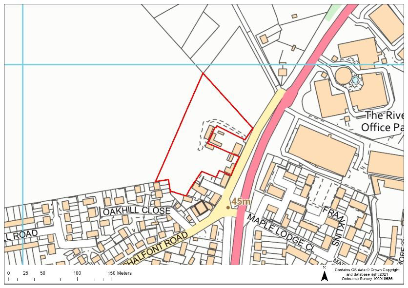 |
Current Use | Market gardening | |||
| Dwelling Capacity | 55 | ||||
| Green Belt | Yes. If allocated, the Green Belt boundary would have to be revised. | ||||
| Phasing | 1-5 years | ||||
| Comments A detailed heritage impact assessment and an archaeological assessment would be required prior to any development in order to protect and mitigate any potential adverse impacts to heritage assets in the vicinity of the site. Any proposals would need to take account of the protected trees in the site and provide suitable mitigation to address surface water flood risk and groundwater flood risk on areas of the site. The site is in Groundwater Source Protection Zone 1; a preliminary risk assessment to determine whether there is contamination of the site, and whether remediation works would be needed, would be required at the pre-application stage to support any proposals on the site. The site would be required to provide open space and play space. |
|||||
Question 48 Do you agree that that Site CFS31 is an appropriate development site? If not, please outline your reasons. |
MC11:
| Site Ref. | MC11 | Site | Garages to rear of Longcroft Road | Size (ha): | 0.06 |
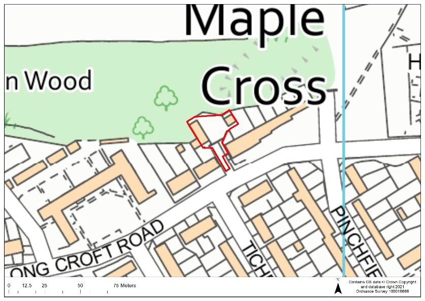 |
Current Use | Garages | |||
| Dwelling Capacity | 5 | ||||
| Green Belt | No | ||||
| Phasing | 11-15 years | ||||
| Comments The site is in Groundwater Source Protection Zone 1; a preliminary risk assessment to determine whether there is contamination of the site, and whether remediation works would be needed, would be required at the pre-application stage to support any proposals on the site. |
|||||
Question 49 Do you agree that that Site MC11 is an appropriate development site? If not, please outline your reasons. |
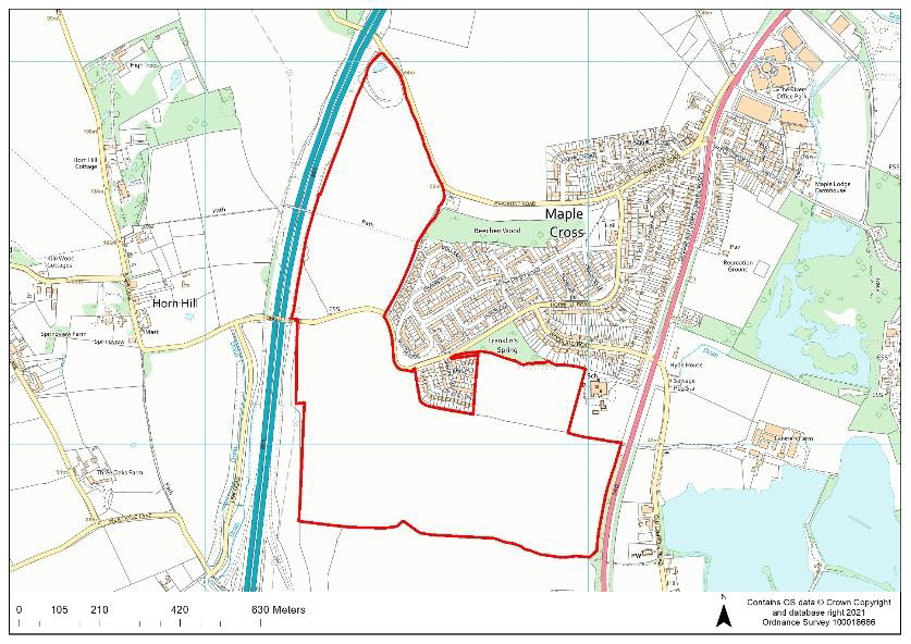
EOS12.2:
| Site Ref. | EOS12.2 | Site | Land to the west and south of Maple Cross | Size (ha): | 52.2 |
 |
Current Use | Agricultural | |||
| Dwelling Capacity | 1,500 & a 90-bedroom care home (equivalent to 47 dwellings) | ||||
| Green Belt | Yes. If allocated, the Green Belt boundary would have to be revised. | ||||
| Phasing | 1-15 years | ||||
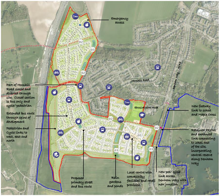
| Comments A detailed heritage impact assessment and an archaeological assessment would be required prior to any development in order to protect and mitigate any potential adverse impacts to heritage assets. Potential noise and air quality issues arising from the site’s proximity to the M25 would also need to be addressed. Any proposals would need to take account of the presence of public right of ways within the site and protected trees adjacent to the site as well as providing suitable mitigation to address surface water flood risk and groundwater flood risk on areas of the site. The majority of the site is in Groundwater Source Protection Zone 1 and the remainder in Groundwater Source Protection Zone 2; a preliminary risk assessment to determine whether there is contamination of the site, and whether remediation works would be needed, would be required at the pre-application stage to support any proposals on the site. Upgrades to the wastewater network would likely be required if the site were to be developed. The site would be required to provide primary education facilities (proposed as an extension to the existing Maple Cross JMI and Nursery School), a local centre (including local shops, community facilities, a nursery and flexible commercial space), a GP surgery, open space, play space and improvements to bus stops and an extended bus route through the site. |
|||||
Question 50 Do you agree that that Site EOS12.2 is an appropriate development site? If not, please outline your reasons. |
Indicative Masterplan (EOS12.2):
2.19 The following masterplan provides an indication of the quantum of housing, layout and infrastructure provision that could be supported on the site however the final detailed masterplan will be decided at the planning
application stage should the site be allocated for housing. We are not seeking comments on the indicative masterplan and it is for illustrative purposes only.
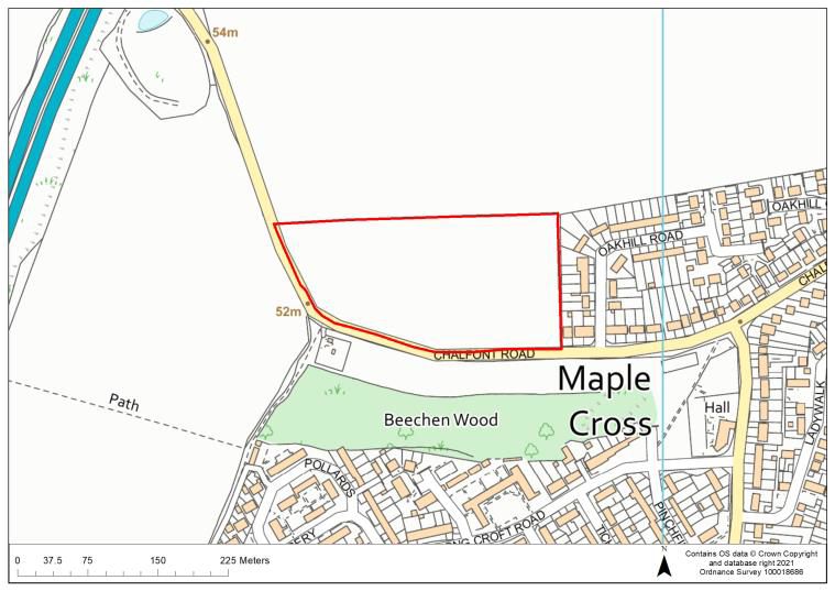
EOS12.3
| Site Ref. | EOS12.3 | Site | Land to the north of Chalfont Lane | Size (ha): | 3.7 |
 |
Current Use | Agricultural | |||
| Dwelling Capacity | 176 | ||||
| Green Belt | Yes. If allocated, the Green Belt boundary would have to be revised | ||||
| Phasing | 1-10 years | ||||
| Comments A detailed heritage impact assessment would be required prior to any development in order to protect and mitigate any potential adverse impacts to heritage assets. Potential noise and air quality issues arising from the site’s proximity to the M25 would also need to be addressed. Any proposals would need provide suitable mitigation to address surface water flood risk and groundwater flood risk on areas of the site. The site is in Groundwater Source Protection Zone 1; a preliminary risk assessment to determine whether there is contamination of the site, and whether remediation works would be needed, would be required at the pre-application stage to support any proposals on the site. The site would be required to provide open space and play space. |
|||||
Question 51 Do you agree that that Site EOS12.3 is an appropriate development site? If not, please outline your reasons. |
MOOR PARK & EASTBURY
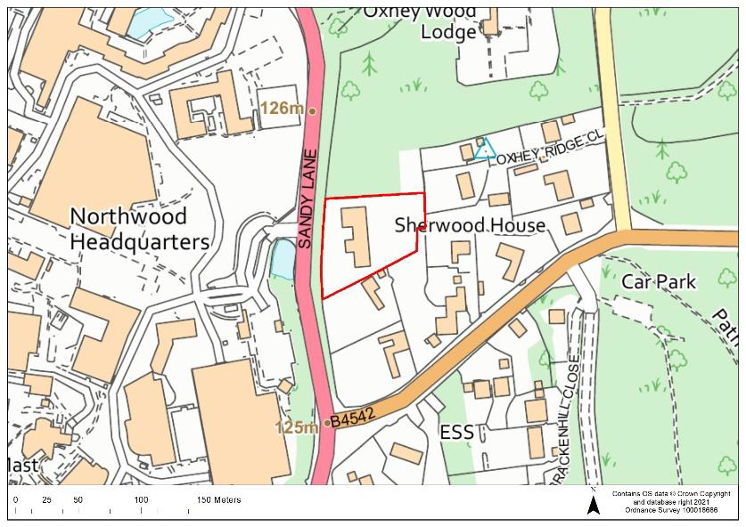
CFS22:
| Site Ref. | CFS22 | Site | Knoll Oak, Sandy Lane, Northwood | Size (ha): | 0.5 |
 |
Current Use | Residential dwelling (vacant) | |||
| Dwelling Capacity | 35 | ||||
| Green Belt | Yes. If allocated, the Green Belt boundary would have to be revised. | ||||
| Phasing | 1-5 years | ||||
| Comments Proposals would need to provide suitable mitigation to address surface water flood risk on areas of the site and development would need to take account of protected trees within the site. The site would be required to provide open space and play space. |
|||||
Question 52 Do you agree that that Site CFS22 is an appropriate development site? If not, please outline your reasons. |
OXHEY HALL
ACFS13b:
| Site Ref. | ACFS13b | Site | Land at Hampermill Lane (larger site) | Size (ha): | 2.8 |
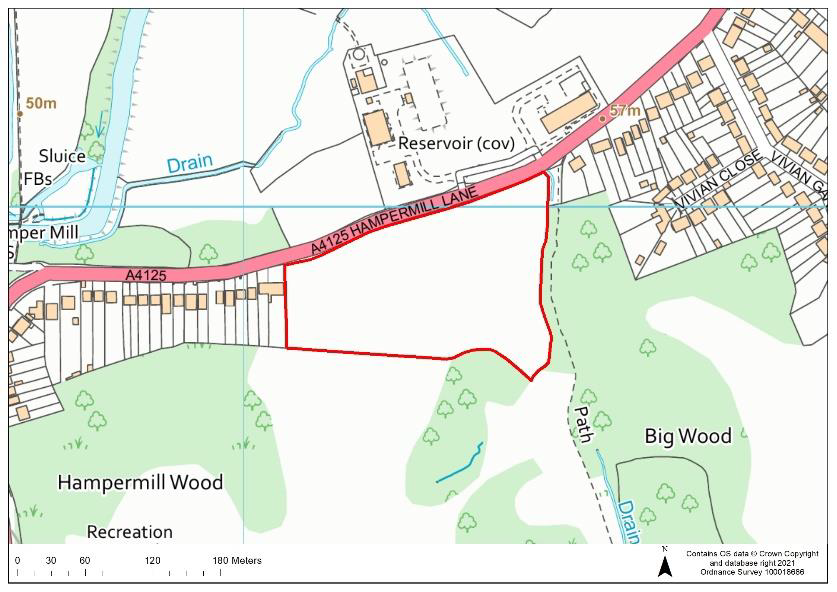 |
Current Use | Agricultural | |||
| Dwelling Capacity | 133 | ||||
| Green Belt | Yes. If allocated, the Green Belt boundary would have to be revised. | ||||
| Phasing | 6-10 years | ||||
| Comments A detailed heritage impact assessment would be required prior to any development in order to protect and mitigate any potential adverse impacts to heritage assets in the vicinity of the site. Any proposals would need to provide suitable mitigation to address surface water flood risk on areas of the site. The site is in Groundwater Source Protection Zone 1; a preliminary risk assessment to determine whether there is contamination of the site, and whether remediation works would be needed, would be required at the pre-application stage to support any proposals on the site. The site would be required to provide open space and play space. |
|||||
Question 53 Do you agree that that Site ACFS13b is an appropriate development site? If not, please outline your reasons. |
RWA6:
| Site Ref. | RWA6 | Site | 165-167 Hampermill Lane, Oxhey Hall | Size (ha): | 0.14 |
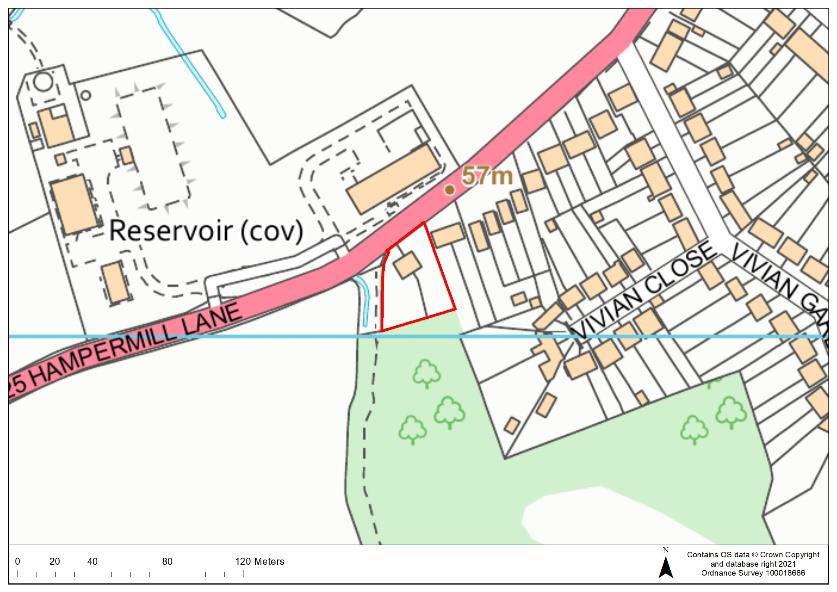 |
Current Use | Residential dwellings (vacant) | |||
| Dwelling Capacity | 6 | ||||
| Green Belt | No | ||||
| Phasing | 1-5 years | ||||
| Comments The site is in Groundwater Source Protection Zone 1; a preliminary risk assessment to determine whether there is contamination of the site, and whether remediation works would be needed, would be required at the pre-application stage to support any proposals on the site. Proposals would need to provide suitable mitigation to address groundwater flood risk on areas of the site. A detailed heritage impact assessment and an archaeological assessment would be required prior to any development in order to protect and mitigate any potential adverse impacts to heritage assets. |
|||||
Question 54 Do you agree that that Site RWA6 is an appropriate development site? If not, please outline your reasons. |
PCS16:
| Site Ref. | PCS16 | Site | Vivian Gardens, Oxhey Hall | Size (ha): | 0.33 |
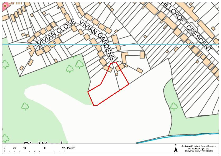 |
Current Use | Residential gardens | |||
| Dwelling Capacity | 8 | ||||
| Green Belt | No | ||||
| Phasing | 1-5 years | ||||
| Comments The site is in Groundwater Source Protection Zone 1; a preliminary risk assessment to determine whether there is contamination of the site, and whether remediation works would be needed, would be required at the pre-application stage to support any proposals on the site. Development would need also to take account of protected trees within the site. |
|||||
Question 55 Do you agree that that Site PCS16 is an appropriate development site? If not, please outline your reasons. |
2.20 The site below is an existing housing allocation in the Oxhey Hall area. The site was allocated in the Site Allocations LDD (adopted 2014) but has not yet been built out. The site will therefore be carried forward into the new Local Plan.
H24:
| Site Ref. | H24 | Site | The Fairway, Green Lane, Oxhey Hall | Size (ha): | 0.35 |
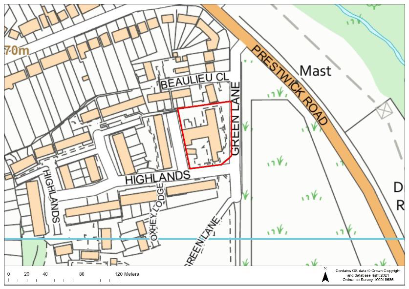 |
Current Use | Residential care home | |||
| Dwelling Capacity | 32 | ||||
| Green Belt | No | ||||
| Phasing | 1-5 years | ||||
| Comments The site is an existing housing allocation in the Site Allocations LDD (adopted 2014). The site is in Groundwater Source Protection Zone 1; a preliminary risk assessment to determine whether there is contamination of the site, and whether remediation works would be needed, would be required at the pre-application stage to support any proposals on the site. Development would need to take account of protected trees within the site and would need to provide suitable mitigation to address surface water flood risk on areas of the site. Delivery of the site depends on an alternative mode of provision being made for the care home. The site would be required to provide open space and play space. |
|||||
SOUTH OXHEY
CFS52a:
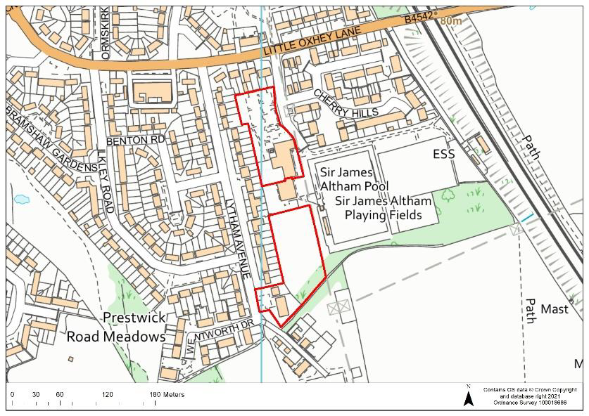
| Site Ref. | CFS52a | Site | Former Sir James Altham School, Little Oxhey Lane, South Oxhey | Size (ha): | 1.3 |
 |
Current Use | Former swimming pool & car park, grassland, vacant residential care home | |||
| Dwelling Capacity | 43 | ||||
| Green Belt | No | ||||
| Phasing | 6-10 years | ||||
| Comments The southern part of the site is an existing housing allocation in the Site Allocations LDD (adopted 2014) (Site H32). An archaeological assessment would be required prior to any development in order to protect and mitigate any potential adverse impacts to heritage assets of archaeological interest and proposals would need to provide suitable mitigation to address surface water flood risk on areas of the site. The former swimming pool has now been replaced by a newly constructed facility in the locality. As part of any development, the residential care home on the site would need to be re-provided on the site or on an alternative site in the local area. Development of the site would also be required to provide an additional 15 car parking spaces and a coach parking space to serve Oxhey Jets Football Club which is adjacent to the site. The site would be required to provide open space and play space. |
|||||
Question 56 Do you agree that that Site CFS52a is an appropriate development site? If not, please outline your reasons. |
AS13:
| Site Ref. | 58 AS13 |
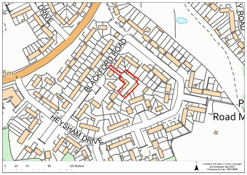
Site | Garages at Blackford Road, South Oxhey | Size (ha): | 0.1 |
 |
Current Use | Garages | |||
| Dwelling Capacity | 7 | ||||
| Green Belt | No | ||||
| Phasing | 11-15 years | ||||
| Comments Development would need to provide suitable mitigation to address surface water flood risk on areas of the site. |
|||||
Question 57 Do you agree that that Site AS13 is an appropriate development site? If not, please outline your reasons. |
AS31:
| Site Ref. | 58 AS31 |
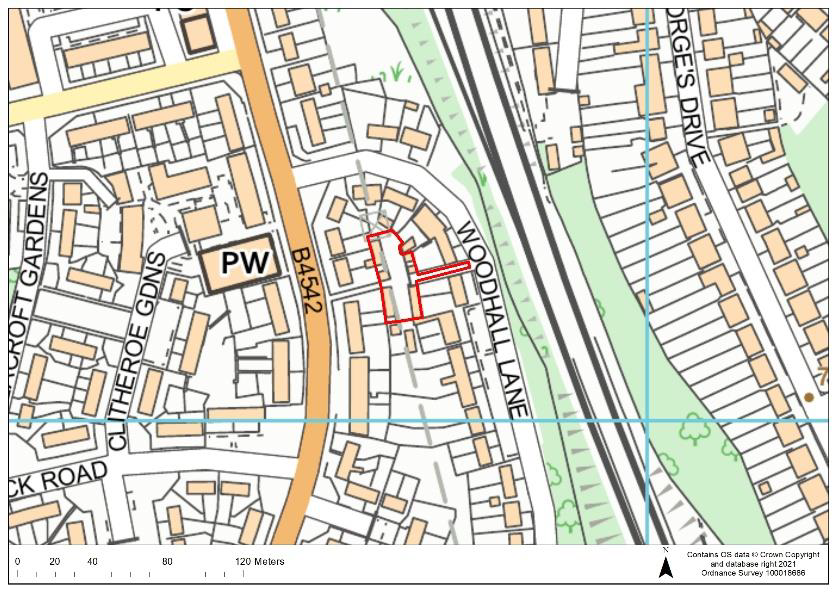
Site | Garages at Woodhall Lane, South Oxhey | Size (ha): | 0.09 |
 |
Current Use | Garages | |||
| Dwelling Capacity | 6 | ||||
| Green Belt | No | ||||
| Phasing | 11-15 years | ||||
| Comments Development would need to provide suitable mitigation to address surface water flood risk on areas of the site. |
|||||
Question 58 Do you agree that that Site AS31 is an appropriate development site? If not, please outline your reasons. |
NW34a:
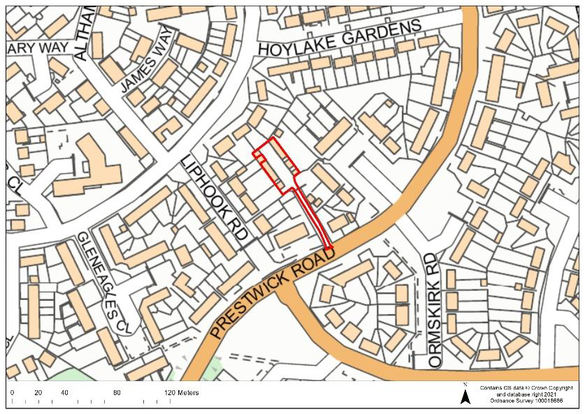
| Site Ref. | NW34a | Site | Garages rear of the Dick Whittington Pub, South Oxhey | Size (ha): | 0.09 |
 |
Current Use | Garages | |||
| Dwelling Capacity | 6 | ||||
| Green Belt | No | ||||
| Phasing | 11-15 years | ||||
| Comments Development may need to provide mitigation to address surface water flood risk along the access road to the site. |
|||||
Question 59 Do you agree that that Site NW34a is an appropriate development site? If not, please outline your reasons. |
2.21 The site below is an existing housing allocation in the South Oxhey area. The site was allocated in the Site Allocations LDD (adopted 2014) but has not yet been built out. The site will therefore be carried forward into the new Local Plan.
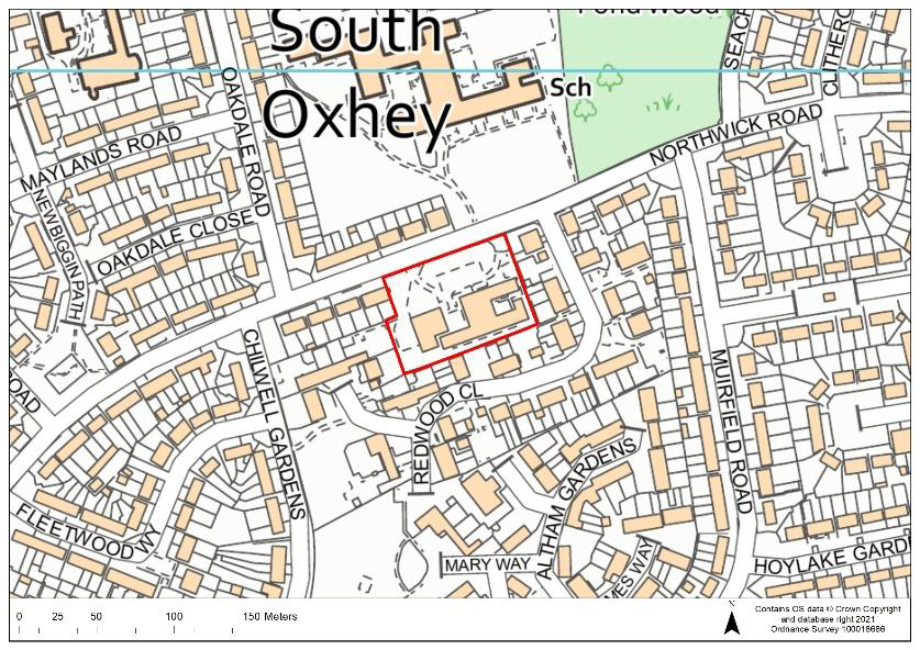
BR20:
| Site Ref. | BR20 | Site | Northwick Day Centre, Northwick Road, South Oxhey | Size (ha): | 0.56 |
 |
Current Use | Day centre | |||
| Dwelling Capacity | 48 | ||||
| Green Belt | No | ||||
| Phasing | 1-5 years | ||||
| Comments The site is part of an existing housing allocation in the Site Allocations LDD (adopted 2014) relating to the wider South Oxhey regeneration area (H29). Development would need to provide suitable mitigation to address surface water flood risk impacting the site and proposals would need to take account of protected trees within the site. The Northwick Road Day Centre facility would need to be re-provided in the local area as part of any development. The site would be required to provide open space and play space. |
|||||
CARPENDERS PARK
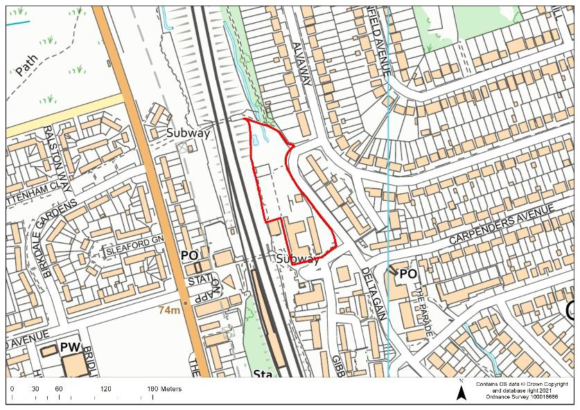
CFS12:
| Site Ref. | CFS12 | Site | Kebbell House and land to rear Delta Gain, Carpenders Park | Size (ha): | 0.9 |
 |
Current Use | Offices | |||
| Dwelling Capacity | 68 | ||||
| Green Belt | No | ||||
| Phasing | 1-10 years | ||||
| Comments Part of the site, to the north, is located in Flood Zone 3b; no development would be permitted on the area of the site in Flood Zone 3b. An 8 metre buffer from residential development and the main river which flows through the site will also be required. Proposals would need to provide suitable mitigation to address groundwater flood risk, surface water flood risk and fluvial flood risk on areas of the site. Any development would need protect the public right of way adjacent to the north of the site and take account of potential noise issues arising from the site’s proximity to the railway line. The site would be required to provide open space and play space. |
|||||
Question 60 Do you agree that that Site CFS12 is an appropriate development site? If not, please outline your reasons. |
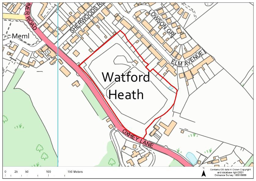
CFS13:
| Site Ref. | CFS13 | Site | Land at Oxhey Lane, Watford Heath | Size (ha): | 2.8 |
 |
Current Use | Agricultural | |||
| Dwelling Capacity | 119 | ||||
| Green Belt | Yes. If allocated, the Green Belt boundary would have to be revised | ||||
| Phasing | 1-10 years | ||||
| Comments Any development will need to take into consideration the medium pressure gas pipeline which runs along the northern and eastern boundaries and an appropriate buffer from the pipeline to development will be required. A detailed heritage impact assessment and an archaeological assessment would be required prior to any development in order to protect and mitigate any potential adverse impacts to heritage assets. Proposals would need to provide suitable mitigation to address the surface water flood risk along the southern boundary and development would be required to take account of the presence of the protected trees. The site would be required to provide open space and play space. |
|||||
Question 61 Do you agree that that Site CFS13 is an appropriate development site? If not, please outline your reasons. |
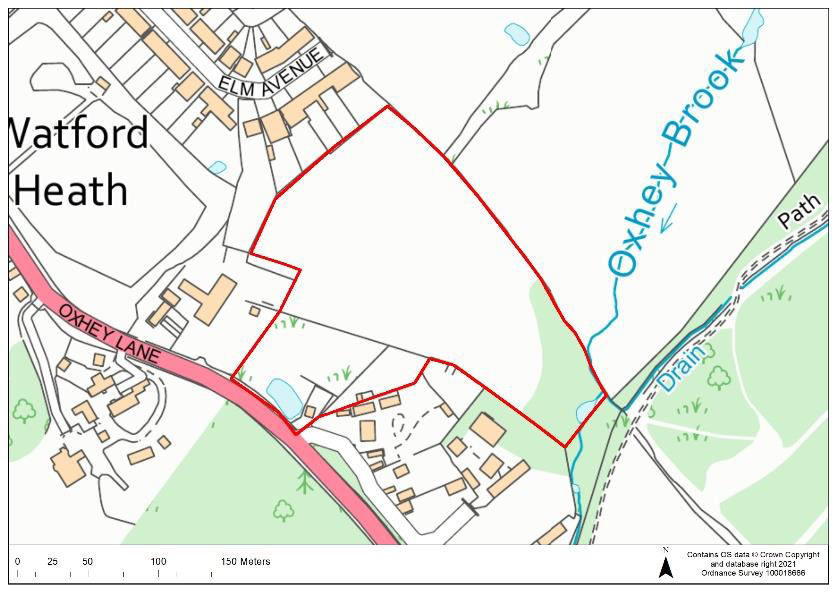
CFS14:
| Site Ref. | CFS14 | Site | Land north of Oxhey Lane | Size (ha): | 3.4 |
 |
Current Use | Agricultural | |||
| Dwelling Capacity | 149 | ||||
| Green Belt | Yes. If allocated, the Green Belt boundary would have to be revised | ||||
| Phasing | 1-10 years | ||||
| Comments Any development will need to take into consideration the medium pressure gas pipeline which runs through the north of the site and an appropriate buffer from the pipeline to development will be required. A detailed heritage impact assessment and an archaeological assessment would be required prior to any development in order to protect and mitigate any potential adverse impacts to heritage assets. Proposals would need to provide suitable mitigation to address the surface water flood risk along the southern boundary and development would be required to take account of the presence of the protected trees. Potential contamination of the site due to the area of historic landfill within the site would also need to be addressed. The site would be required to provide open space and play space. |
|||||
Question 62 Do you agree that that Site CFS14 is an appropriate development site? If not, please outline your reasons. |
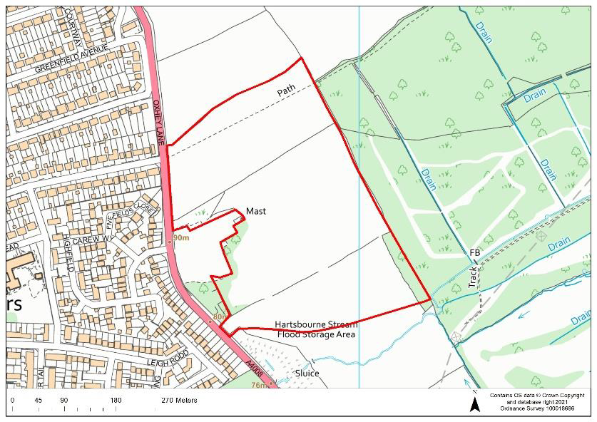
CFS69a:
| Site Ref. | CFS69a | Site | Land at Carpenders Park Farm – Northern Parcel | Size (ha): | 12.7 |
 |
Current Use | Agricultural | |||
| Dwelling Capacity | 485 | ||||
| Green Belt | Yes. If allocated, the Green Belt boundary would have to be revised | ||||
| Phasing | 6-15 years | ||||
| Comments The southern boundary of the site is a 10 metre distance from the Hartsbourne Flood Storage Area and development would need to ensure protection of this designated flood risk asset. Proposals would need to provide suitable mitigation to address the surface water flood risk on areas of the site and development would need protect the public right of way running through the site to the north. The site would be required to provide open space, play space and a primary school. |
|||||
Question 63 Do you agree that that Site CFS69a is an appropriate development site? If not, please outline your reasons. |
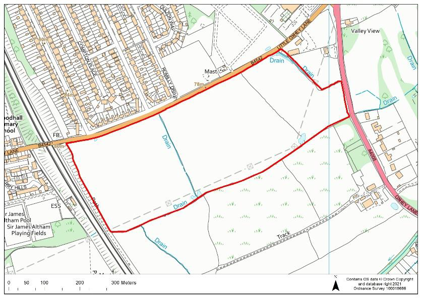
PCS47:
| Site Ref. | PCS47 | Site | South of Little Oxhey Lane | Size (ha): | 19.4 |
 |
Current Use | Agricultural | |||
| Dwelling Capacity | 678 | ||||
| Green Belt | Yes. If allocated, the Green Belt boundary would have to be revised | ||||
| Phasing | 6-15 years | ||||
| Comments Any development will need to take into consideration the medium pressure gas pipeline which runs along the southern boundary and an appropriate buffer from the pipeline to development will be required. A buffer would also be required between development and the overhead electricity cables which run through the site. A detailed heritage impact assessment and an archaeological assessment would be required prior to any development in order to protect and mitigate any potential adverse impacts to heritage assets. Proposals would need to provide suitable mitigation to address the surface water flood risk on areas of the site as well as providing appropriate buffer distances to the ordinary watercourses within the site. The site is adjacent to Harrow AQMA so potential air quality issues would also need to be addressed. The site would be required to provide open and play space and there may be a requirement for a primary school on site. |
|||||
Question 64 Do you agree that that Site PCS47 is an appropriate development site? If not, please outline your reasons. |
5 This relates to the numbers of years following adoption of the Local Plan, which is anticipated for 2023 according to the Local Development Scheme: https://www.threerivers.gov.uk/egcl-page/local-development-scheme. Appendix 1 shows the indicative housing delivery trajectory which the indicative phasing for each site is based on; it is requested that in response to this consultation, landowners/promoters provide information on their anticipated delivery trajectories for sites.
< Previous | ^ Top | Next >