
2.1.1 This section contains an overview of the opportunities and constraints of the whole town, how the WNP area fits within it, and what makes it special. In order to plan the town’s future, we must understand the area, the issues facing it, and the problems and opportunities that the plan could address, as well as any constraints.
2.1.2 Windsor is internationally famous as the home of Royalty and has international significance as a major heritage site and showcase for the UK. Nearly 7 million tourists visit the town every year, mostly on day trips, to the Castle, River, LEGOLAND, Racecourse and Great Park. The 2018 Royal Wedding was viewed by 2 billion people worldwide and attracted over 100,000 visitors on the day. The town’s appearance and heritage are therefore extremely important.
2.1.3 Its historic attractions and royal links, its location in the South East of England and commutable proximity to London and the Thames valley, along with good external transport links make it a small/medium sized town that punches above its weight in terms of facilities for residents and tourists. The 32,000 or so residents consequently have access to many more amenities than would normally be expected of a town of similar size, and people as a result aspire to live here. It is the main shopping town for the Royal Borough of Windsor and Maidenhead, and attracts shoppers from a wide area, and visitors nationally and internationally.
2.1.4 It has traditionally been a mixed “working” town, generally prosperous with numerous businesses, low unemployment and with residents from a wide range of socio-economic levels, a variety of business types and buildings of varied architectural periods and forms. The WNP area is encircled by Green Belt and special landscapes, although set within this Green Belt are two tourism businesses, LEGOLAND and Windsor Racecourse, which are important for the local economy. The economy is not wholly tourism though, and has always been mixed with several major health and military institutions, some medium sized commercial offices and some small-scale light industry, and small businesses scattered through the town.
2.1.5 The town’s popularity brings considerable pressures on housing, parking, on movement of both pedestrians and vehicles, and on the green and open spaces, parks and gardens that are within and surround it, as well as on business and essential employment land. The pressure for development sometimes means that green space becomes a key target for those seeking a new plot, if not sympathetically handled this leads to a deterioration of the attractiveness of the town.
2.1.6 Surrounded by Metropolitan Green Belt, geographically the urban area of Windsor is a rectangular shape, with Windsor Castle and the town centre in one corner. Sandwiched between the River Thames and Windsor Castle and Great Park, the town has of necessity grown out westwards.
2.2.1 The town centre and central riverside are not in the WNP area (they are in the W2030 area which intends to do a business-led Neighbourhood Plan) but there is large degree of interdependence between the two areas. The WNP area depends upon all of the amenities in the central Windsor area, and vice versa.
2.3.1 The WNP area comprises the mostly suburban part of the town. It is socially, economically and architecturally mixed with the majority being family housing with gardens. There are higher density Georgian and Victorian terraces mostly in the inner suburbs and mostly low-density family housing with gardens in the outer suburbs along with an increasing number of flats on re-developed plots. There are historic pockets mixed with assorted 20th century suburbs, (some of which are more attractive than others), some wealthy areas of private housing, some social housing, and one area of above average deprivation, and the majority is everything in between.
2.3.2 House and land prices have increased to around fourteen times average incomes, and redevelopments mean the town is becoming increasingly dense. At present there are still green surroundings, from the green belt all around the town, as well as gardens, parks and green pockets and tree lined streets in the urban area, although the urban greenery is under pressure particularly through the need for parking and more homes.
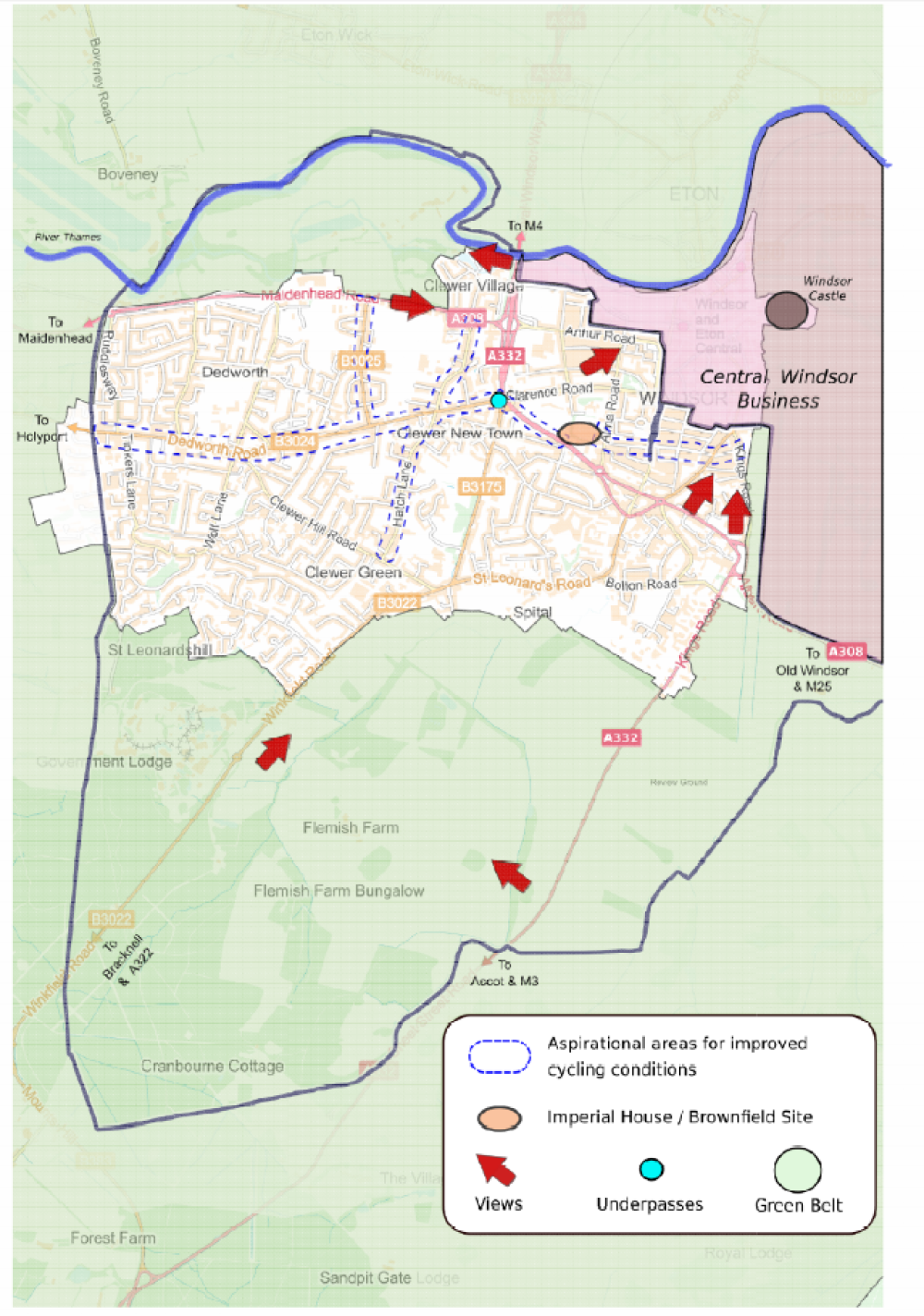
2.3.3 The town centre and suburbs are separated by busy “A” roads, some of which are dual carriageways (A308, A332) and “B” roads (B3022, B3173) which are through roads. This configuration leads to issues for people and businesses who live and work here as the distance between the town centre and southern and western suburbs are a long walk, bike or car journey away and the issues are exacerbated by underpasses, busy roads and traffic congestion and parking pressures.
2.3.4 The immediate population close to the town centre is relatively small4, with relatively more living in the middle and outer suburbs where there are fewer facilities within walking distance. Community facilities are also under pressure and these will become increasingly important as densities increase. The total Windsor population was 308515 at the 2011 census having increased by just under 10% since 2001. At the same growth rate, it is estimated that the current population in 2020 is around 32500.
2.3.5 The area economy is changing as it is losing offices and small business premises including light industrial which are being redeveloped to housing both through RBWM policy as well as under Permitted Development Rights. Small and growing businesses are finding it hard to find space to operate.
2.4.1 Under the NPPF there is a presumption in favour of sustainable development and this is a thread that runs through the NP. However, it is important to understand any limitations for development around the WNP area. There are a considerable number of constraints discussed below.
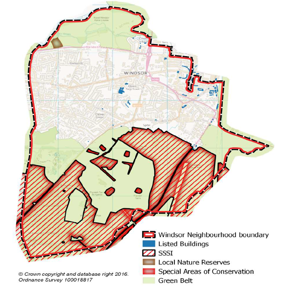
2.4.2 Green Belt The built area of Windsor is totally surrounded by Metropolitan Green Belt, not all of which is publicly accessible, and this green feel defines the surround of the town and much of the suburban area.
2.4.3 Within this Green Belt is Windsor Great Park to the south and east of the town which has been under Crown ownership for over 800 years and is very environmentally and historically important. This parkland, farmland and forest is on the Register of Parks and Gardens of special historic interest in England6. Parts are also internationally designated (EU) as a Special Areas of Conservation (such as Windsor Forest) and have national biodiversity and landscape designations such as Sites of Special Scientific Interest, and areas of Special Landscape Importance. These are recognised in the Conservation of Habitats and Species Regulation 2010, and the Wildlife and Countryside Act 1981.
2.4.4 The Crown Estate manages Windsor Great Park which is designated under the Crown Estate Act and as such cannot be sold. The Crown also owns the freehold of urban land and buildings in the eastern and southern fringe of the urban area of the town. Their historically cautious approach to development is likely to continue, limiting development in these areas.
2.4.5 The Crown Estate allows public access to some parts of the Great Park and this is extremely important for recreation for the people from the WNP area as well as for the whole region. However large parts of the Great Park are private. As population increases across the whole region RBWM and the Crown Estate consider that the edges of the Great Park are deemed at increasing threat from change and potential environmental stresses from public access. Where there are some more sensitive areas access is “permissive7” and there are a limited number of on-foot only access points (such as off Winkfield Road where a footpath runs through Crown farmland) and limited nearby parking capacity at those access points.
2.4.6 Tourist businesses in the Green Belt. LEGOLAND to the south and Windsor Racecourse and Windsor Racecourse Marina sites are to the north in the Area. All are “washed over” by the Green Belt so any development on these sites is subject to national and local Green Belt policy.
2.4.7 The Thames River Corridor runs to the north of the WNP and is protected for its landscape value and is a RBWM designated Green Corridor. It includes Sutherland Grange Nature Reserve (also designated by RBWM).
Map 3: Green Belt and Special Landscapes and Listed Buildings in the WNP area
2.4.8 A large part of the north of the Area is within areas of flood risk (flood risk zones 2 and 3). Policies to protect the area from flood risk are covered at National and Borough level, and the town benefits from the Jubilee River Flood Protection scheme, and the Bourne Ditch embankment and sluice gate, next to Stag Meadow. Many other streams and “river ditches” cross the area although are not always visible, such as beside Imperial Road and under Hatch Lane and its adjoining roads.
2.4.9 There is still a growing flood risk from climate change, from both river, surface water, and ground water levels, and there is also risk to a critical drinking water catchment area which is spread across part of the area.
2.4.10 Green and Community Infrastructure. Open Spaces within the urban environment are valuable community resources which underpin the quality of life. Various urban open spaces, including parks, natural and semi-natural areas, amenity green spaces, allotments, school playing fields, sports pitches, and play areas are relied on by the population. RBWM Open Space Study 2019 and the earlier Open Space Audit 2008 identified that there are shortages of some types of open space against established standards and they are unevenly distributed.
2.4.11 Windsor is generally well provided with various community centres, sports and recreation and leisure facilities, and churches, which provide essential facilities and support an active leisure, recreation and community life in the WNP area8. Many leisure and sports facilities are along the riverside or in the Home Park east of the town centre, (W2030 area) so some distance from peoples’ homes, particularly for those in the west of town.
2.4.12 Heritage. Protecting Windsor’s heritage and enhancing the wider overall setting for Windsor Castle (probably the most recognised and important castle in the country and a designated Ancient Monument) is of the utmost importance for Windsor. There are four designated Conservation Areas in Windsor, three of which are in the WNP area (Inner Windsor, Mill Lane/Clewer Village, Trinity Place/Clarence Crescent) and around 70 Listed buildings are spread across the WNP area, mostly in the Clewer Corridor, Clewer Village, on the fringe of the town centre and on the edge of the Great Park. (See Map 3). There are also many more in the centre of town in the neighbouring Windsor2030 NP area. There are also a considerable number of buildings that are not listed but that are locally significant, and which enable an appreciation of Windsor’s history, including churches and churchyards.
2.5.1 Our consultations with local people and SWOT analysis showed that the area is generally well served with community and leisure facilities, and the main planning concerns centre around the appearance of the town, fewer facilities in the west of the neighbourhood area, the threats to and gradual erosion of heritage, preserving community facilities, open spaces, employment and shopping, Green Belt, and dealing with increasing traffic congestion. The need for affordable housing was also a concern. Each of these challenges presents opportunities to make a positive change via the WNP.
2.5.2 Our investigations have shown that there are no obvious or substantial greenfield or brownfield sites within the WNP which do not already have planning permission within the area boundary or are not covered by existing Borough plans or by Green Belt or other designations restricting developments. We therefore predict that we will see new housing or business development mostly consisting of redevelopments of “windfall sites”, (that is as yet unknown sites which will be put forward for development by their owners), or infill between them, or attempts to use some existing open spaces against community wishes, and some increased development in already-developed Green Belt business sites such as LEGOLAND and Windsor Racecourse.
2.5.3 We have therefore concentrated mostly on the design aspects to help to shape any future windfall redevelopments which will inevitably come forward. We have an opportunity to influence the design of redevelopments and infill to improve the appearance of the town and the way it functions, and to direct developments to where local people want to see them. The WNP approach is to create policies and projects which can help to deal with the increasing densities in a way that is acceptable to the community through better design that is more aligned with the wishes of the community.
2.5.4 The plan sets out what would be permissible in terms of design and character, and also gives some suggestions as to general locations where development could occur both for housing and retail sites. It is very difficult to be specific on what densities should be in a town where character is so diverse as what might be appropriate in St Leonards Hill will not be in central Windsor9. The appropriate quantum of development would be based on professional judgements on a case-by-case basis guided by strategic policies in the Borough Local Plan.
2.5.5 The WNP has tried to avoid repeating policies which are already covered in the adopted and emerging BLP, while at the same time being aware of the likely time lag between the WNP and BLP adoption timetable.
2.5.6 The WNP is required to generally conform to the strategic policies of the BLP, whilst it has to take into account evidence on the allocated strategic sites. It can seek to influence some aspects such as design and detail through its policies.
The opportunities for specific places are summarised overleaf (See Map 4: Main Area Opportunities).
Map 4 Main Area Opportunities
3 Based on 2011 census data www.rbwm.gov.uk/public/jsna_ward_profiles the most common housing types are as follows; Park Ward; Detached 37.74%, Castle Without Ward 35.78% terraced, Clewer East Ward Flats 33.02%Clewer North Ward Semi Detached 41.49%, Clewer South ward not available
4 Castle Without ward in 2011 census had a population of 6952, Clewer North 7728, Clewer South 5341, Clewer East 5450, Park 5290.
5 The Register of historic parks and gardens is managed by Historic England
6 Excluding Eton and Castle Ward had 2748 in 2011 of which it is estimated that 800 are in the Windsor2030 area.
7 To the right of the Crown and can be withdrawn at any time.
8 See the WNP website Evidence Base for the list of community facilities
9 AECOM (The Former Imperial House and Adjacent sites Masterplanning and Design Advice) estimates housing density in central Windsor (terraced streets of Queens Road/St Marks Road) as 52 dwellings per hectare
< Previous | ^ Top | Next >