< Previous | Next >
Appendix A – Allocated Sites
1. The following appendix provides information on the minerals and waste sites (listed alphabetically) that are allocated within the Plan:
| Site Reference |
Site Name |
Location |
Local Plan Authority |
Proposal |
| WA 1 |
Berkyn Manor Farm |
Horton |
RBWM |
Waste Management |
| WA 2 |
Horton Brook Quarry |
Horton |
RBWM |
Waste Management |
| MA 1 |
Horton Brook and Poyle Quarry Extension |
Horton |
RBWM |
Sand and Gravel Extraction |
| TA 1 |
Monkey Island Wharf |
Bray |
RBWM |
Aggregate Wharf |
| MA 2 |
Poyle Quarry Extensions |
Horton |
RBWM |
Sand and Gravel Extraction |
| WA 3 |
StubbingsCompound |
Pinkneys Green |
RBWM |
Waste Management |
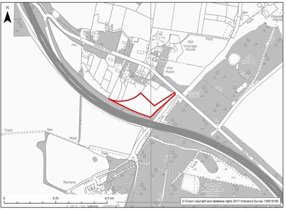
2. The delineation of the site is shown by the red boundary. In the case of mineral extraction sites, it does not mean that working would extend to the site boundary as the allocation needs to include provision for buffer zones and mitigation measures. These will be determined through detailed site investigation, taking into account the development considerations for each site. Such measures will be covered by the planning permission, including the relevant conditions and / or legal agreements. It may also include provision for ancillary development such as plant, offices, access and weighbridge.
3. In the case of waste sites, types of waste activity that are considered suitable are provided. More detail on these activities is provided in Appendix B.
4. Development considerations are identified in the text accompanying each map in this appendix. They should be addressed alongside the other policies of the Plan. Development should be designed with appropriate mitigation measures, where applicable, to avoid or mitigate its impacts on the environment and local communities. Development considerations apply to minerals and waste developments in Central and Eastern Berkshire but may also include impacts that extend beyond the Plan boundary.
5. Development cannot be permitted if it may negatively affect the integrity of European protected sites. The development requirements for maintaining this integrity are identified with an asterisk (*) in the text and must be addressed.
6. The Plan does not specify how the development considerations may be addressed. This will be assessed at the planning application stage, which should present the most appropriate responses, which are likely to include detailed site appraisals and Environmental Impact Assessment (EIA). These will identify what effects the development will have, and how to tackle them. All assessment information and suggested mitigation measures should be clearly identified and form part of the pre-application discussions and consultation with communities.
7. For any development proposal at the sites identified in the Plan, all elements of the Plan need to be considered as well as the site-specific development considerations outlined in this Appendix.
Berkyn Manor, Horton (WA 1)

Local Planning Authority: The Royal Borough of Windsor & Maidenhead
Existing Use: Working farm estate with some industrial use.
Proposal: Green waste and / or energy recovery.
Waste activity categories:
| Category |
Activity |
| 1 |
Open sites or ancillary open areas (possibly biological treatment) |
| 2 |
Mix of enclosed buildings/plant and open ancillary areas (possibly involving biological treatment) |
| 3 |
Enclosed industrial premises (small scale) |
| 4 |
Enclosed industrial premises (large scale) |
Area: 2.7 ha
Development Considerations:
Ecology
- Protection of South West London Waterbodies Special Protection Area (SPA)/Ramsar*.
- Impacts on all roosting and foraging areas used by qualifying bird species of South West London Waterbodies SPA and Ramsar, in particular open grasslands within and adjacent to the site*.
- Impacts to Wraysbury reservoir Site of Special Scientific Interest (SSSI), Staines Moor SSSI, Wraysbury No.1 Gravel Pit SSSI, Wraysbury and Hythe End Gravel Pit SSSI.
- Impacts to Queen Mother Reservoir Local Wildlife Site (LWS), Arthur Jacob Nature Reserve LWS, Colne Brook LWS Horton and Kingsmead Lakes LWS.
- Consideration of hydrological impacts.
- Retention and buffering of hedgerows within site.
- Consideration of the Colne Valley Gravel Pits and Reservoirs Biodiversity Opportunity Area in restoration or operational landscaping.
Landscape & Townscape
- Existing vegetation should be conserved and protected, and additional buffer planting established to all boundaries.
- Enhanced screening is required.
- Green Belt compensation due to development of the site must take into consideration the Colne and Crane Valleys Green Infrastructure Strategy (2019) and its key principles.
- Particular consideration should be given to whether the development is not inappropriate in the Green Belt, preserves its openness and does not conflict with the purposes of including land within it.
Historic Environment:
- A Heritage Impact Statement is required.
- The setting of Grade II Listed Building to the south needs to be considered.
Transport:
- Further investigation is required for a suitable access onto Stanwell Road for waste uses.
- A Transport Assessment or Statement is required.
- A HGV Routeing Agreement will be required.
Flood Risk & Water Resources
- A Flood Risk Assessment and Hydrological/Hydrogeological Assessment will be required. The Flood Risk Assessment will need to ensure that the development will be safe, not increase off site flood risk and consider all sources of flooding. Only development classified as water compatible or essential infrastructure (with exception test) will be permitted in Flood Zone 3b.
- Proximity to major / minor aquifers, in addition to Source Protection Zones.
Horton Brook Quarry, Horton (WA 2)
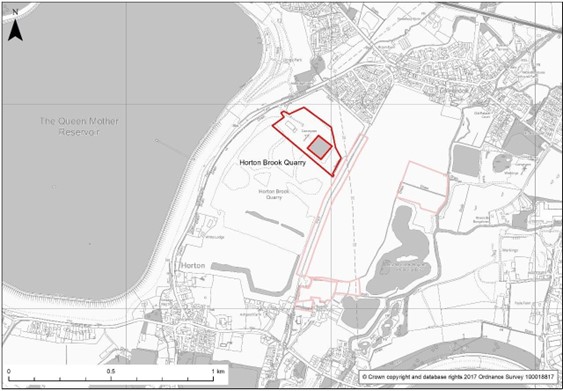
Local Planning Authority: The Royal Borough of Windsor & Maidenhead
Existing Use: Existing operational sand and gravel quarry.
Proposal: Inert recycling
| Category |
Activity |
| 1 |
Open sites or ancillary open areas (possibly biological treatment) |
| 2 |
Mix of enclosed buildings/plant and open ancillary areas (possibly involving biological treatment) |
| 3 |
Enclosed industrial premises (small scale) |
| 4 |
Enclosed industrial premises (large scale) |
Area: 5.5 ha
Development Considerations:
Ecology
- Protection of South West London Waterbodies Special Protection Area (SPA)/Ramsar*.
- Impacts on all roosting and foraging areas used by qualifying bird species of South West London Waterbodies SPA and Ramsar, in particular open grasslands within and adjacent to the site*.
- Impacts to Wraysbury reservoir Site of Special Scientific Interest (SSSI), Staines Moor SSSI, Wraysbury No.1 Gravel Pit SSSI, Wraysbury and Hythe End Gravel Pit SSSI.
- Impacts to Queen Mother Reservoir Local Wildlife Site (LWS), Arthur Jacobs Nature Reserve LWS, Colne Brook LWS, and Horton and Kingsmead LWS
- Retention and protection of a part of the site for nature conservation purposes during operation.
- Considerations of the objectives of the Colne Valley gravel Pits and Reservoirs Biodiversity Opportunity Areas (BOA) in restoration or operational landscaping proposals.
Landscape & Townscape
- Proposals should ensure adequate space is set aside for the establishment of a strong new landscape structure for this group of sites (Poyle Quarry and extensions, Berkyn Manor and Horton Brook) including large scale native species tree belts.
- Integrate new structures with effective screen planting, including along boundaries.
- Restoration proposals should have reference to the Colne Valley Gravel Pits and Reservoirs BOA.
- Green Belt compensation due to development of the site must take into consideration the Colne and Crane Valleys Green Infrastructure Strategy (2019) and its key principles.
- Particular consideration should be given to whether the development is not inappropriate in the Green Belt, preserves its openness and does not conflict with the purposes of including land within it.
Transport:
- A Transport Assessment or Statement is required.
- An HGV Routeing Agreement will also be required (or maintain existing).
Flood Risk & Water Resources
- A Flood Risk Assessment and Hydrological/Hydrogeological Assessment will be required. The Flood Risk Assessment will need to ensure that the development will be safe, not increase off site flood risk and consider all sources of flooding. The site is adjacent to the Queen Mother Reservoir. Any works will need to demonstrate that they do not impact on the structural stability of the reservoir embankment.
- Proximity to major / minor aquifers, in addition to Source Protection Zones.
- Consideration of the Colne Brook and its river corridor.
Utilities
- Statutory safety clearance of National Grid infrastructure.
Horton Brook and Poyle Quarry Extension, Horton (MA 1)
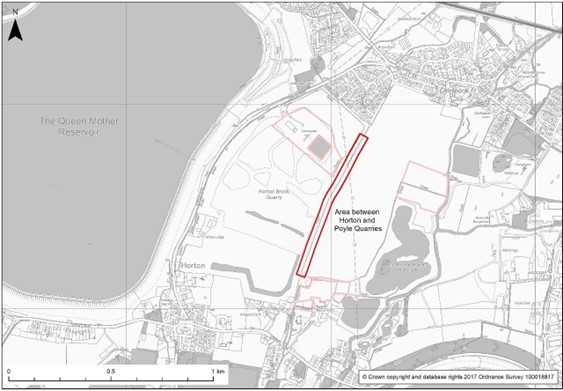
Local Planning Authority: The Royal Borough of Windsor & Maidenhead
Existing Use: Bridleway (Colne Valley Way).
Proposal: Extension to Horton Brook and Poyle Quarry extracting 150,000 tonnes of sand and gravel with no processing on site.
Area: 3.75 ha
Development Considerations:
Ecology
- Protection of South West London Waterbodies Special Protection Areas (SPA) and Ramsar*.
- Impacts on all roosting and foraging areas used by qualifying bird species of South West London Waterbodies SPA and Ramsar, in particular open grasslands adjacent to the site*.
- Impacts on Arthur Jacob Nature Reserve Local Wildlife Sites (LWS), Queen Mother Reservoir LWS, Colne Brook LWS and Horton and Kingsmead Lakes LWS.
- Consideration of indirect impacts such as air and noise pollution.
- Restoration proposals should have reference to the Colne Valley Gravel Pits and Reservoirs Biodiversity Opportunity Area.
Landscape & Townscape
- The Colne Valley Way Trail will need to be temporarily diverted and re-established as part of the restoration and applicants will need to work closely with the relevant authorities and the Colne Valley Regional Park.
- The bridleway route and restoration of the site must seek to improve connectivity and enhance the local public access network and give consideration to the Colne and Crane Valleys Green Infrastructure Strategy (2019).
Transport:
- A Transport Assessment or Statement is required.
- An HGV Routeing Agreement will also be required (or maintain existing).
Historic Environment
- The archaeological potential is high and will need to be addressed during the determination of the planning application.
Flood Risk & Water Resources
- A Flood Risk Assessment and Hydrological/Hydrogeological Assessment is required. The Flood Risk Assessment will need to ensure that the development will be safe, not increase off site flood risk and consider all sources of flooding.
- Consideration of near-by private and licenced abstractions.
- Site located within a principal aquifer.
Utilities
- Statutory safety clearance of National Grid infrastructure.
Monkey Island Lane Wharf, Bray (TA 1)
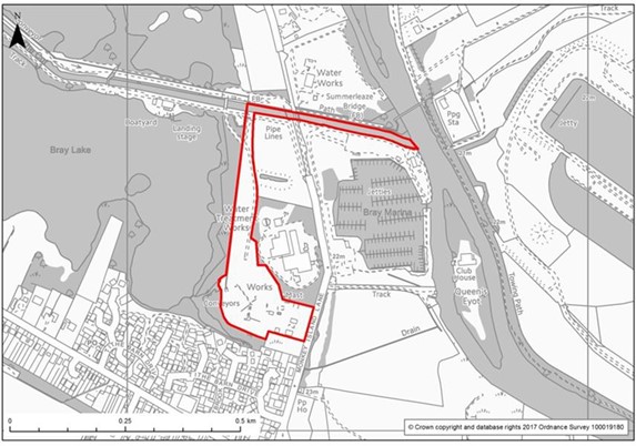
Local Planning Authority: The Royal Borough of Windsor & Maidenhead
Existing Use: No current use.
Proposal: Transport sand and gravel along the River Thames, through a waterway known as the ‘Cut’ to a proposed new barge unloading facility. Sand and gravel then sent to Monkey Island Lane processing plant via conveyor.
Development Considerations:
Ecology
- Protection of Bray Pennyroyal field Site of Special Scientific Interest (SSSI) and Bray Meadows SSSI.
- Impacts to Greenway corridor Local Wildlife Site (LWS) within site, ensuring functionality as wildlife corridor is not compromised, and losses compensated.
- An ecological assessment of the impact of making The Cut (Greenway Corridor LWS) navigable will be required.
- Impacts to Bray Pit Reserve LWS.
- Consideration of the Biodiversity Opportunity Area including ecological improvements to the Cut in line with the LWS citation.
- A River restoration compensation scheme will be required and is subject to approval by the Environment Agency. This should consist of habitats restoration for the equivalent amount of the river that will be made navigable and should be located immediately upstream. River restoration should include bed raising by adding gravels and creating marginal shelves to restore the channel to more natural dimensions.
- Retention of semi-natural habitats within site to accommodate protected species.
- Consideration of pollution impacts to riverine habitats both from construction and the ongoing impacts of using the river for navigation purposes.
- A morphological assessment of the impact of making The Cut navigable will be required including related impacts on the River Thames and its river corridors.
- A Water Framework Directive Assessment is required.
Landscape & Townscape
- Strengthen existing landscape structure with new tree and hedgerow planting to integrate new structures.
- Maintain and enhance the setting of the public access route to Bray Lake Recreation Area.
Historic Environment
- Archaeological issues would remain a material consideration and will need to be addressed during the determination of the planning application.
Transport:
- A Transport Assessment or Statement is required.
- An HGV and Barge Routeing Agreement will be required.
Flood Risk & Water Resources
- Site largely within Flood Zone 2/3 and Groundwater Source Protection Zone (1) – a Flood Risk Assessment and Hydrological/Hydrogeological Risk Assessment will be required. The FRA will need to ensure that the development will be safe, not increase off site flood risk and consider all sources of flooding. Fluvial modelling will need to be undertaken to provide a detailed assessment of fluvial flood risk and to ensure floodplain compensation is provided where required. Modelling should include the 5%, 1% and 1%+ climate change AEP.
- Proximity to major / minor aquifers, in addition to Source Protection Zones.
- A morphological assessment of the impact of making The Cut navigable will be required including related impacts on the River Thames and its river corridors.
Poyle Quarry (Extensions), Horton (MA 2)
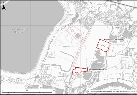
Local Planning Authority: The Royal Borough of Windsor & Maidenhead
Existing Use: Arable fields
Proposal: Extension to Poyle Quarry extracting 250,000 tonnes of sand and gravel with no processing on site.
Area: 4 ha and 2 ha
Restoration: Agriculture at original ground levels.
Development Considerations:
Ecology
- Protection of South West London Waterbodies Special Protection Areas (SPA) and Ramsar*.
- Impacts on all roosting and foraging areas used by qualifying bird species of South West London Waterbodies SPA and Ramsar, in particular open grasslands within and adjacent to the site*.
- Impacts on Arthur Jacob Nature Reserve Local Wildlife Sites (LWS), Queen Mother Reservoir LWS, Colne Brook LWS and Horton and Kingsmead Lakes LWS.
- Consideration of indirect impacts such as air and noise pollution.
Landscape & Townscape
- Proposals should ensure adequate space is set aside for the establishment of a strong new landscape structure for this group of sites (Poyle Quarry and extensions, Berkyn Manor and Horton Brook) including large scale native species tree belts.
- Consideration needs to be given to the realignment of the Colne Valley Way, and the quality of its setting.
- Restoration proposals should have reference to the Colne Valley Gravel Pits and Reservoirs Biodiversity Opportunity Area.
Historic Environment
- A Heritage Impact Assessment is required.
- The archaeological potential is high and will need to be addressed during the determination of the planning application.
- The setting of Grade II Listed Building to the south needs to be considered.
Transport:
- A Transport Assessment or Statement is required.
- An HGV Routing Agreement will be required.
Flood Risk & Water Resources
- Both sites partly within Flood Zones 2 and/or 3
- The site is not located within a Source Protection Zone (SPZ) but the closest SPZ is located to the west of the site approximately under 1km away.
- Proximity to major / minor aquifers, in addition to Source Protection Zones. A Flood Risk Assessment and Hydrological/Hydrogeological Assessment will be required. The FRA will need to ensure that the development will be safe, not increase off-site flood risk and consider all sources of flooding. Fluvial modelling will need to be undertaken to provide a detailed assessment of fluvial flood risk and to ensure floodplain compensation is provided where required. Modelling should include the 5%, 1% and 1%+ climate change AEP.
- Consideration of the Colne Brook and its river corridor
Utilities
- Statutory safety clearance of National Grid infrastructure.
Stubbings Compound, Pinkneys Green, Maidenhead (WA 3)
Local Planning Authority: The Royal Borough of Windsor & Maidenhead
Existing Use: Hardstanding with permission for agricultural barn.
Proposal: Green waste processing (excluding open windrow composting).
Waste activity categories:
| Category |
Activity |
| 2 |
Mix of enclosed buildings/plant and open ancillary areas (possibly involving biological treatment) |
| 3 |
Enclosed industrial premises (small scale) |
Area: 2 ha
Development Considerations:
Ecology
- Impacts and adequate buffering of Maidenhead Thicket Local Wildlife site (LWS).
- Impacts to Carpenters Wood, Dungrove Hill LWS, and Temple Golf Course LWS.
- Retention and buffer of mature boundaries.
- Consideration of surface water discharge to ground pollution.
Landscape & Townscape
- Enhanced screen planting is required for adjacent residential properties.
- Particular consideration should be given to whether the development is not inappropriate in the Green Belt, preserves its openness and does not conflict with the purposes of including land within it.
Transport:
- A Transport Assessment or Statement will be required – this would need to demonstrate sufficient splays from the existing access.
- An HGV Routeing Agreement will be required.
Flood Risk & Water Resources
- Site in Groundwater Source Protection Zone (3) – a Hydrogeological Risk Assessment will be required. A site-specific Flood Risk Assessment (FRA) is required. The FRA will need to ensure that the development will be safe, not increase off site flood risk and consider all sources of flooding.
- Proximity to major / minor aquifers, in addition to Source Protection Zones.
< Previous | ^ Top | Next >
