
GENERAL OVERVIEW
As previously stated, our Neighbourhood Plan has a significant percentage of land that is within the Green Belt and the Flood Plain. In the main, we are restricted from being able to develop in any meaningful way to satisfy an increase in population in our ward.
The most common form of building that has taken place over the past few years has been redevelopments of properties and domestic extensions, and this is the most likely form of future development.
In Wraysbury, there may well be pockets of land that could be developed, particularly on dry islands with a recognised escape route. Whilst in Horton, it is recognised that there is greater potential for development.
The community has expressed strong views about its desire to retain the character of the area and to protect our green and leafy environment. The following policies have been designed to respond to these demands.
a) SUSTAINABLE DEVELOPMENT
REASONED JUSTIFICATION
The intention of this policy is to indicate the overall support for development that is sustainable within the community and that reflects the presumption in favour of sustainable development contained in the National Planning Policy Framework.
The Plan supports a collaborative approach to development and, in particular, subscribes to the principle of early engagement of the public and stakeholders in the preparation of major residential developments that will affect their community in the long term. The NPPF states:“Early engagement has significant potential to improve the efficiency and effectiveness of the planning application system for all parties. Good quality pre-application discussion enables better co-ordination between public and private resources and improved outcomes for the community.”
Development proposals which accord with the policies in the Neighbourhood Plan will be supported, unless material considerations indicate otherwise. Development proposals will also be supported where relevant policies in the Neighbourhood Plan are out of date or silent unless:
The Borough Council and the two Parish Councils will take a positive approach and seek to work with applicants and other stakeholders to encourage the formulation of development proposals that can be approved.
To achieve this, development proposals of 10 or more dwellings should actively engage with the relevant Parish Council and the community in the preparation of the planning application by way of Development Details (see Appendix). In particular this will include the mix of units, the design and layout of the development and should be in accordance with all other Neighbourhood Plan policies.
MANAGEMENT OF THE WATER ENVIRONMENT
REASONED JUSTIFICATION
With the rivers Colne, Thames and the Colne Brook being nearby, severe flooding has happened on several occasions over the past few years. It is necessary, therefore, for the design and layout of new development to show how it will address the specific requirements of our area in relation to flood risk, especially since our vacuum operated sewerage system is vulnerable to flooding.
The experience from the recent 2014 floods has put the importance of flood risk management at the forefront of the community’s mind when considering new development in the Plan area. National planning policy regarding flooding is set out in paragraphs 100–104 of the NPPF 2012, which is further elaborated in the Planning Practice Guidance.
The thrust of national policy is to avoid putting vulnerable development, which includes residential development, into areas that are at risk of flooding. The approach is that wherever possible, such development should be placed outside Flood Zones 2 and 3, as shown on the Environment Agency’s Flood Maps, thereby avoiding putting more people and property at risk. This is known as the sequential approach i.e. identifying locations for new development which lie outside the Flood Plain. This would require any allocation in the Plan area to be where the buildings or structures will not be at risk of flooding.
This is complicated by the fact that so much of the Neighbourhood Plan area lies within the Green Belt. At the wider Royal Borough level, the opportunity arises of locating new development elsewhere in areas that do not flood. This is the approach that was identified in the Royal Borough’s Strategic Flood Risk Assessment. The avoidance of flood risk areas is one of the strategic policies set out in the adopted local plan which, while it predates the NPPF, has followed established national advice on flood risk. Recent national advice in the Planning Practice Guidance recognises that some constraints outweigh the benefits of providing more housing developments and specifically quotes locations where development is to be restricted as those at risk from flooding along with other examples that include Green Belt and Local Green Space.
The relevant Local Plan policy is Policy F1 of the adopted Local Plan which includes a general presumption against residential and non-residential development if, by itself or cumulatively with other development, it will:
These principles are reflected in the Neighbourhood Plan policy on this important topic. Policy F1 does allow the replacement of homes on a site, allowing for a floorspace by floorspace basis, but also allowing for the property to be extended by a maximum of 30 2m. A similar limit applies to those extensions that require planning permission.
This Neighbourhood Plan reflects both national advice and local plan policy by including general presumption against all new buildings in areas liable to flood unless it is infrastructure or facilities that have to be located by the river such as boathouses. This is to ensure that no additional people are placed at risk when flooding reoccurs nor should the placing of new buildings in the floodplain take up flood storage capacity which could lead to the flooding of areas not currently liable to flood.
New development in the Plan area can be allowed in terms of flood plain policy if it can be demonstrated that the levels of the site are above the level of water in the 1 in 1000-year flood event – these are known as Dry Islands.
However, to be allowed, the applicant will be expected to demonstrate that any residents will have a safe exit route to land which will remain outside the flood area in serious events, as the flood water can remain in place for many weeks. Experience of recent floods has demonstrated that there is a viable evacuation route down Staines Road.
It is likely that in the context of flood plain policy the only acceptable residential development in Flood Zones 2 and 3 will be replacement dwellings and the extension of dwellings. Current policy allows a 302m increase in floor space. However, notwithstanding the national and local policy presumption against inappropriate development in flood areas, existing properties generally still have permitted development rights (unless previously withdrawn) which now allow sizeable extensions and the construction of large ancillary buildings within the curtilage. The extent of an enlargement built using the permitted development route can be greater than allowable under planning policy and additionally imposes no controls over the method of construction and floor levels. This could allow solid substructures which do not allow water to flow or be stored under the living accommodation thereby displacing flood water and increasing flood risk to neighbouring properties.
The Neighbourhood Plan wishes to encourage development that is as flood resilient as possible and recognises that pushing residents to utilise their permitted development rights will generally result in less sustainable development. This can be achieved by a policy that allows properties still to be extended to the extent allowable by the permitted development rights but must be constructed in a way that maximises flood resilience and resistance through the exercise of planning control.
POLICY NP/SUSTDEV 02 – MANAGEMENT OF THE WATER ENVIRONMENT
Development proposals for residential or non-residential development within the areas shown within Flood Zones 2 and 3 as shown on the Environment Agency’s Flood Maps will not be supported apart from the one-for-one replacement of houses and extensions to existing houses up to the limit allowable under the permitted development rights granted by Parts A and E of Schedule 2 of the Town and Country Planning (General Permitted Development Order) 2015 or such secondary legislation that replaces it.
The design and construction of new buildings should have regard to national flood resilience guidance and other relevant policies in the development plan. Additionally, action should be taken where appropriate to improve and reduce the overall flood risk.
b) HOUSING
GOOD QUALITY DESIGN
REASONED JUSTIFICATION
This Neighbourhood Plan supports the NPPF’s objective to achieve excellence in design, especially design that will help establish a “strong sense of place” and “create attractive and comfortable places to live, work and visit” (NPPF para 58).
We already have a rich variety of architectural styles in the area and we would like to see new development contribute to this variety, while at the same time being sympathetic to the existing character of the area and natural environment (as is also reflected in our policy NP/DG2 regarding density, scale and bulk of new builds).
Our policies do not restrict development; instead they challenge applicants to deliver innovative development of high quality design that responds to its surroundings and is appropriate for our area.
Our Character Assessment should be used to inform the design approach in a planning application. The extent to which this is demonstrated in the development proposals should determine whether the proposal is in keeping with the character of an area.
POLICY NP/HOU1 – GOOD QUALITY DESIGN
Development proposals should:
| Accommodation type | Number of car parking spaces |
|---|---|
| 1 bedroom house or flat | Minimum of 1 off road space |
| 2–3 bedroom dwelling | Minimum of 2 off road spaces |
| 4 or more bedrooms | Minimum of 3 off road spaces |
| Developments of 5+ dwellings | Additional 2 spaces per 5 dwellings |
FOOTPRINT, SEPARATION, SCALE & BULK
REASONED JUSTIFICATION
The trend in the last few years has been for new developments to be built to a much larger scale than that which is the general norm in our area. This is typified also where houses are built much closer to the boundaries of properties, resulting in loss of green frontage, space around the buildings, loss of privacy to surrounding properties and, when repeated, has a negative impact on the overall streetscape and the built environment.
The bulk and scale of the houses in new developments in the residential neighbourhood has also frequently been much greater than the properties they replace, so that they dominate their surroundings. There is serious concern within the community that this is harming the character of the area which we strongly want to protect and is adversely impacting on the amenity of neighbouring properties.
In the event of new homes being permitted, RBWM will consider the appropriateness or otherwise of a condition being imposed removing permitted development rights to erect side extensions without planning permission.
NP/HOU2.1
New development should respect the footprint, separation, scale, bulk and height of the buildings in the surrounding area generally and neighbouring properties in particular, unless it can be demonstrated that the proposed development would not harm local character.
NP/HOU2.2
All new development should respect:
SMALLER PROPERTIES & HOUSING MIX
REASONED JUSTIFICATION
As typical of villages across the country, a big issue in Horton and Wraysbury is to provide and protect the supply of smaller properties to meet the needs of our community.
It is important to the sustainability of the social fabric of our village community that we ensure a continued mix of housing types that allow people of all generations to live here. Evidence shows there is a demand for smaller units for both first time buyers and those wishing to downsize which is also backed up by the evidence contained within the Berkshire Strategic Housing Market Assessment (Chapter 9). This was a strong and consistent theme that emerged from the public consultation responses and which is one of the key themes that the Neighbourhood Plan needs to address.
Allocation in our neighbourhood of new developments to supply smaller houses is hugely restricted by the Green Belt and the Flood Zones, and recent years have seen the loss of two or three bedroom homes to much larger replacement dwellings. We want to encourage the provision of small houses where possible. In the event of new homes being permitted, RBWM will consider the appropriateness or otherwise of a condition being imposed removing permitted development rights to erect side extensions without planning permission.
NP/HOU3.1
All housing proposals of five or more units should deliver at least 20% of these units as one- or two-bed properties.
NP/HOU3.2
The provision of small properties (one to two bedrooms) suitable for older people and starter homes for young people will be supported, subject to other policies in the Plan.
CHANGE OF USE
REASONED JUSTIFICATION
Because of the difficulties of identifying housing sites to meet local needs, both within and outside the Green Belt, the Plan encourages the redevelopment of previously developed land, i.e. brownfield sites, for housing purposes (so long as there is no greater impact on the openness of the Green Belt). In addition, it also seeks to support the conversion of existing commercial premises, especially if the existing use is no longer viable, or is unneighbourly, to new homes. This could be a ready source of a supply of smaller properties which the Plan is seeking to promote. Such proposals would need to comply with other policies in the development plan, including those related to flooding.
Development proposals for a change of use of existing buildings including commercial sites or for their redevelopment for residential use will be supported where they comply with other relevant policies in the Development Plan.
Where the properties or sites are located within the Green Belt, the developments concerned should have no greater impact on the openness of the Green Belt than that of the existing building or buildings.
WATER SUPPLY, WASTE WATER DRAINAGE, SURFACE WATER AND SEWERAGE INFRASTRUCTURE
REASONED JUSTIFICATION
It is important that with any new development within the Horton and Wraysbury area there is existing capacity for both the water supply and sewerage/wastewater infrastructure. Applicants will be expected to show that there will not be a net increase in demand as a result of the development unless it can be shown that sufficient capacity exists and it will not cause problems for existing residents and businesses. This may require discussions with Thames Water to establish:
Development proposals should demonstrate that there is adequate water supply, waste water capacity and surface water drainage, both on and off the site to serve the development and that it would not lead to problems for existing or new users.
Drainage on the site must maintain separation of foul and surface water flows.
c) BUILT ENVIRONMENT & COMMUNITY ASSETS
EDUCATION
REASONED JUSTIFICATION
Wraysbury Primary School on Welley Road primarily serves Horton and Wraysbury and whilst it has recently been extended, the Neighbourhood Plan is mindful of any future need for further expansion e.g. an attached nursery.
Proposals to extend the Wraysbury Primary School and/or to provide a nursery school on the Primary School site will be supported where:
PROTECTION OF BUILDINGS VALUED BY THE COMMUNITY
REASONED JUSTIFICATION
Heritage assets are defined as a “building, monument, site, place, area or landscape identified as having a degree of significance meriting consideration in planning decisions, because of its heritage interest”. Heritage assets include designated heritage assets and assets identified by the local planning authority (including local listing) (Annex 2, NPPF).
Throughout the Plan area there are buildings and structures that, while not of specific special historic or architectural interest to warrant designation as listed buildings, have a distinct and valued local character and/or appearance that are worthy of retention as part of any proposal.
Remenham House, The Drive, Wraysbury: Part of the Mansion of Remenham and Cow built around 1884.
North Lodge, The Drive, Wraysbury: One of the Remenham lodges built around 1884.
The Windmill, The Splash, Wraysbury: Built in 1995 using timber salvaged from Tilbury Docks Tall Ships sidings by prisoners from the Napoleonic Wars. The windmill is similar in design to one built at Lacey Green near High Wycombe c1650.
The Grange, Windsor Road, Wraysbury: Dating back to the 14th century and used as a vicarage until the late 17th century when it became privately owned. The Great Hall includes large stained glass windows and a minstrels’ gallery.
The former school, Horton Road, Horton: Originally a Church of England Primary School built in 1878 with the aid of a grant from St. Michael’s Church. It remained the school for children from Horton village until it was finally closed in 1973. Since then the building has been renovated and used as offices.
Wraysbury High Street Area: Many of these buildings are Victorian, as recognised in the RBWM Townscape Assessment, which recommends the conservation of the historic gateways of the High Street/Station Road/The Green and High Street/Staines Road/Windsor Road, plus the views along the historic High Street, which includes the Baptist Church and the Perseverance Public House.
Any planned changes will also be given consideration and advice by the established ‘Wraysbury & Horton Heritage Committee’.
POLICY NP/BE2 – HERITAGE ASSETS
The following properties are identified as locally important heritage assets:
Remenham House, The Drive, Wraysbury
North Lodge, The Drive, Wraysbury
The Windmill, The Splash, Wraysbury
The Grange, Windsor Road, Wraysbury
The former school, Horton Road, Horton
Wraysbury High Street Area as per the schedule of buildings below:
The Oast Barn, Staines Road
‘Albert Place’, 6–12 Staines Road
‘Alexandra Villas’, 4 Staines Road
2 Staines Road
56 High Street
14, 16 High Street
Wraysbury Baptist Church
4–12 High Street
15–23 High Street
25 High Street
27–33 High Street
1–3 Station Road
5–7 Station Road
Brook Villa, The Green
Development proposals which would directly or indirectly affect the locally important heritage assets should safeguard and where possible enhance the heritage asset. The effect of a development proposal on the significance of the identified locally important heritage assets will be taken into account in determining the relevant planning application having regard to the scale of any harm or loss and the significance of the heritage asset concerned.
Listed buildings (see panel below) are already afforded protection by national policy and existing local plans as well as enjoying statutory protection, so there is no need for a separate Neighbourhood Plan policy.
LISTED BUILDINGS
Horton
Wraysbury
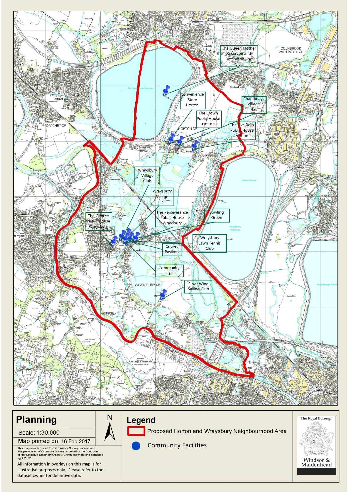
PROTECTION OF COMMUNITY FACILITIES
REASONED JUSTIFICATION
This policy identifies those built community facilities that will be protected from a change of use that will result in a loss of their community value. Some may already have protection from demolition given they are designated heritage assets but this policy seeks to ensure their community value is sustained.
Further, it encourages proposals to enable the facilities to remain viable community facilities, in line with the 2003 Borough Local Plan CF1.
POLICY NP/BE3 – COMMUNITY FACILITIES
Development proposals to sustain or extend the existing community use of the following buildings and the development of new facilities will be supported where they complement the use or viability of the community element of the facility concerned; (as identified on the Community Facilities Map below)
Horton Parish Sites:
Wraysbury Parish Sites:
Proposals that will result in the loss or significant reduction in scale, of a community facility identified in this policy will not be supported unless suitable alternative facilities are provided or it can be demonstrated the existing facility is no longer viable and that an alternative community use cannot be identified for the building concerned.
d) OPEN ENVIRONMENT
LANDSCAPE
REASONED JUSTIFICATION
To protect and maintain our existing green spaces, footpaths and the natural environment for recreation and wellbeing, taking the opportunities offered by the River Thames Scheme to enhance the accessibility, leisure and ecological amenities where possible whilst working in conjunction with the National Trust, Natural England and the Colne Valley Regional Park.
POLICY NP/OE1 – LANDSCAPE
Development should conserve and enhance the quality and character of the landscape in the Neighbourhood Plan area and within the context of the Colne Valley Regional Park. In particular, development will be expected to retain and where possible improve the visual appearance of the land within the Plan area by protecting and enhancing the landscape features such as vegetation, existing trees and hedgerows, and the open nature of the riverside meadows as well as the riparian setting of the Rivers Colne, Thames and the Colne Brook and the flooded gravel pits which are situated in the Plan area.
PROTECTION OF ECOLOGICALLY IMPORTANT SITES
REASONED JUSTIFICATION
The Horton and Wraysbury Plan area has a wide range of ecologically important sites ranging from the Ramsar Sites (e.g. Wraysbury Lakes which are sites of international importance linked to the migration of birds) and nationally designated SSSIs such as Wraysbury & Hythe End Gravel Pits.
POLICY NP/OE2 – ECOLOGY
Development proposals that conserve and enhance biodiversity and comply with other relevant policies will be supported.
Development proposals should give particular regard to ecological networks and should:
Development proposals that would have an unacceptable adverse impact on the ecological or biodiversity resources in the neighbourhood area, and which cannot be appropriately avoided or mitigated, will not be supported.
PROTECTION & MAINTAINING OF FOOTPATHS
REASONED JUSTIFICATION
There exists a network of public rights of way around the two villages which provide access into the countryside and are a valued recreational resource. However, this network is limited compared to other parishes in the Colne Valley and opportunities should be taken to enhance the network and create circular walks for the benefit of local residents. The network of footpaths and bridleways must be protected, maintained and enhanced through such initiatives as the River Thames Scheme and by negotiations with private landowners.
The network of lakes between Horton and Wraysbury are disused gravel pits which are now used for leisure pursuits. They form private fishing lakes, sailing clubs, and a dive centre. There are some lakeside public footpaths, while over time other paths have developed as locals regularly used them for walking and bird watching.
Most of the lakes benefit from designation as Sites of Special Scientific Interest (SSSI) and European Ramsar protection, as the landscape is colonised by a variety of birds and wildlife habitats.
It is the Parish Councils’ intention to keep public footpaths accessible by walking the routes (sometimes referred to as “Beating the Bounds”). In addition, the Wraysbury Walking Group has been formed to ensure established routes and footpaths are regularly used and enjoyed around Horton and Wraysbury by residents of the villages.
POLICY NP/OE3 – PUBLIC RIGHTS OF WAY
Development proposals should be designed and arranged to safeguard existing public rights of way and their settings. Proposals which would involve the loss of a public right of way or where an appropriate and attractive redirection could not be achieved will not be supported.
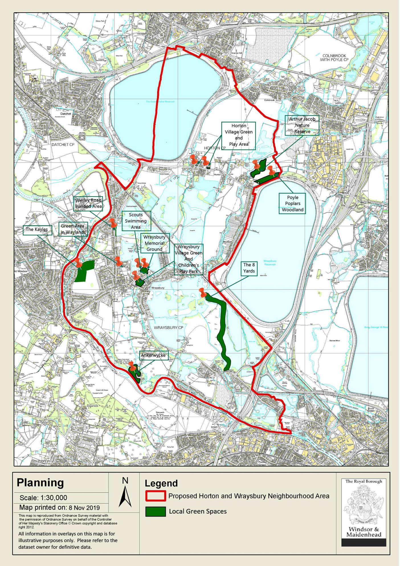
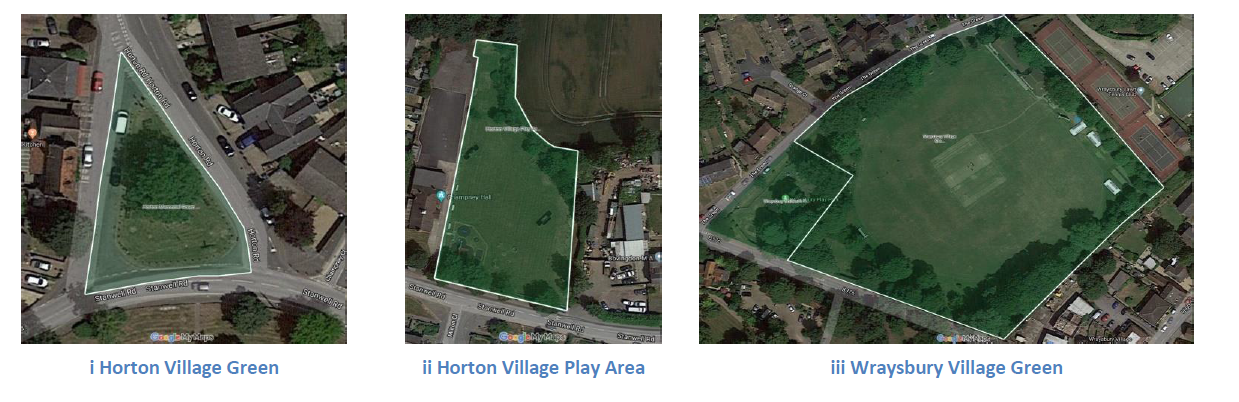
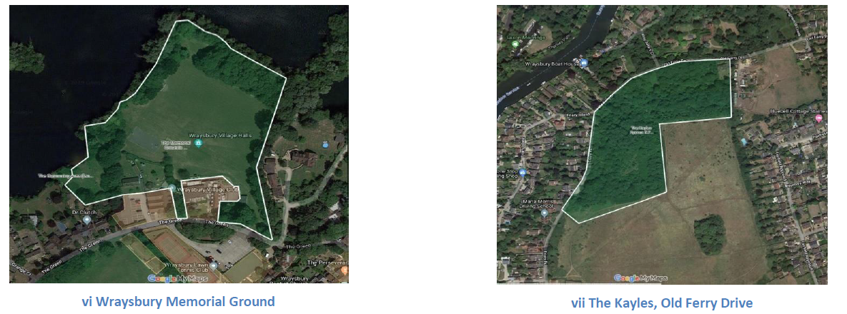
LOCAL GREEN SPACES
REASONED JUSTIFICATION
Under the NPPF, Neighbourhood Plans have the opportunity to designate Local Green Spaces which are of particular importance to the local community. This will afford protection from development other than in very special circumstances.
Paragraph 77 of the NPPF says that Local Green Spaces can be designated:
“where the green area is demonstrably special to a local community and holds a particular local significance, for example because of its beauty, historic significance, recreational value (including as a playing field), tranquillity or richness of its wildlife; and is not an extensive tract of land.”
Green spaces have been identified in the villages of Horton and Wraysbury as detailed below.
Policy OE4 designates Local Green Spaces and applies the approach in the NPPF to their long-term maintenance. The very special circumstances where development may be supported within Local Green Spaces will be a matter for RBWM to determine on a case-by-case basis. However, these circumstances may include proposals which enhance the role and function of a designated Local Green Space and where the proposal would result in the development of appropriate community infrastructure.
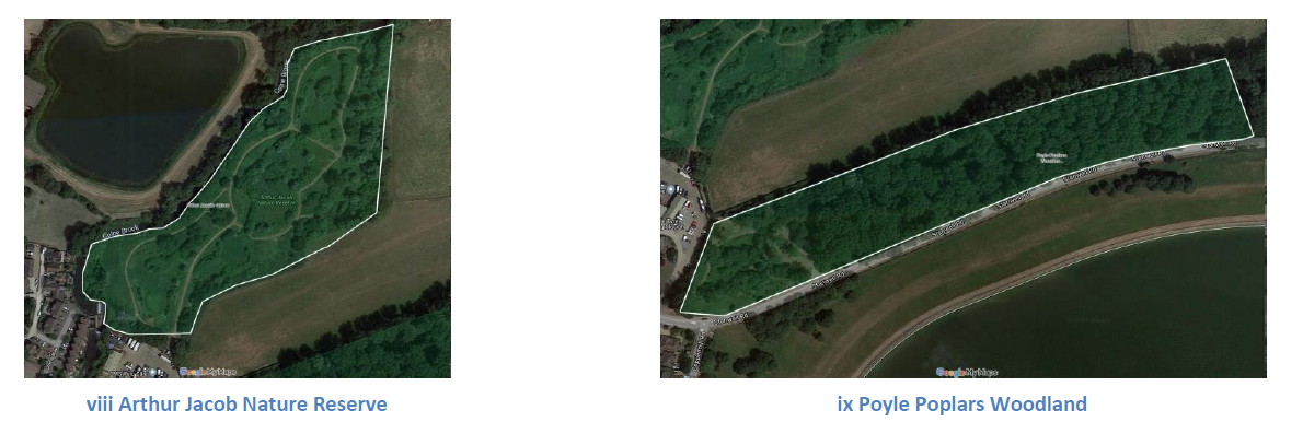
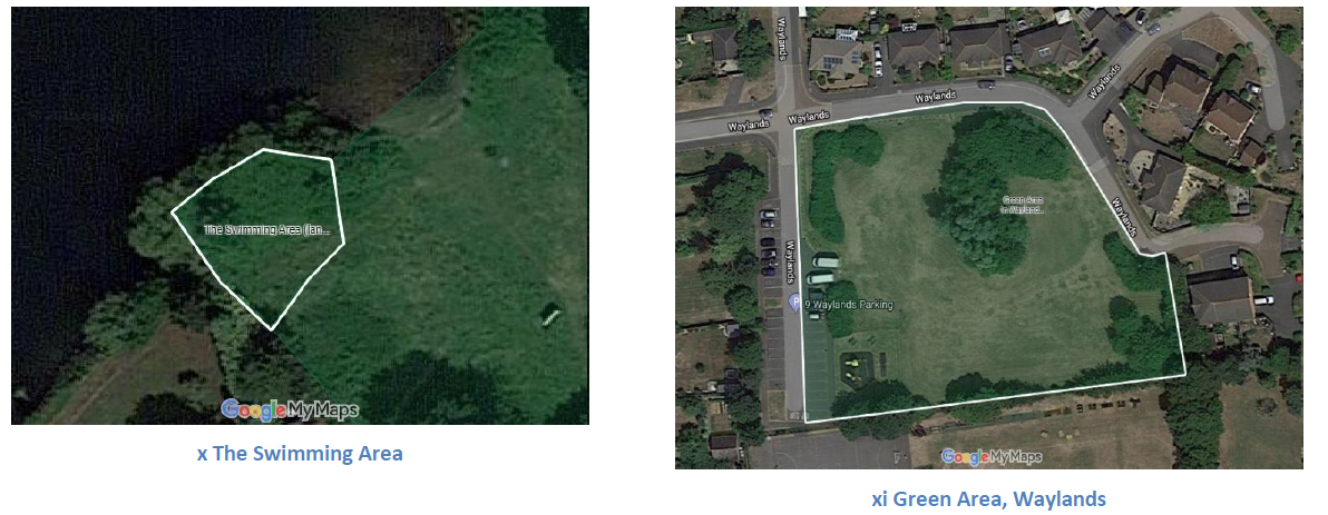
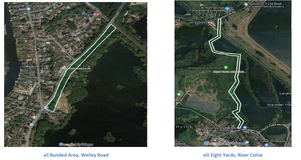
POLICY NP/OE4 – LOCAL GREEN SPACES
The Neighbourhood Plan designates Local Green Spaces in the following locations, as shown on the Local Green Spaces maps on pages 37 to 39.
Development will not be supported within local green spaces unless in very special circumstances.

e) BUSINESS & ECONOMY
RETAIL BUSINESSES
Reasoned Justification
Horton has a single convenience store and Wraysbury has a number of shops that provide services to the villages which are highly valued and which avoid longer trips by car to neighbouring towns and villages. In addition they provide valuable employment to the villages. The protection of local facilities through neighbourhood plans is commended in national planning guidance.
POLICY NP/BUSEC1 – RETAIL BUSINESS
Proposals for the change of use of properties in retail or retail-related use (Class A1 to A5 inclusive) to other uses will not be supported unless it can be demonstrated that the continued retail use is no longer viable and that there is evidence that the property has been marketed on reasonable terms for a 12 month period.
COMMERCIAL PREMISES
REASONED JUSTIFICATION
The Plan recognises the importance to the balance of the community of the importance of existing businesses in the Plan area, both in terms of the services they deliver and also the employment and economic benefits they provide. The policy recognises that often businesses will need to redevelop their property or alter or extend them and the Plan generally supports that investment so long as the proposals comply with other relevant development plan policies.
POLICY NP/BUSEC2 – COMMERCIAL PREMISES
Proposals for the redevelopment of existing employment and commercial premises, or their extension or alteration for continued employment generating uses will be supported subject to the proposals also complying with other relevant policies in the Development Plan.
< Previous | ^ Top | Next >