
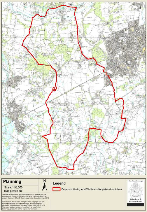
1.1. The Parish Councils of Hurley, Waltham St Lawrence and White Waltham and the Parish Meeting of Shottesbrooke (“the Parish Councils”) have jointly prepared this Neighbourhood Plan for the area designated by the Royal Borough of Windsor and Maidenhead under the provisions of the Localism Act 2011 and the Neighbourhood Planning (General) Regulations 2012. The designated area is shown in Plan A below.
1.2. The purpose of the Neighbourhood Plan is to make planning policies that can be used to determine planning applications in the area.
1.3. Neighbourhood Plans provide local communities with the chance to shape the future development of their areas. Once approved at a referendum, the Plan becomes a statutory part of the development plan for the area and will carry significant weight in how planning applications are decided. Plans must therefore contain only land use planning policies that can be used for this purpose. This often means that there are important issues of interest to the local community that cannot be addressed in a Plan if they are not directly related to planning.
1.4. Although there is considerable scope for the local community to decide on its planning policies, Plans must meet four 'basic conditions'. These are:
1.5. In addition, the Parish Councils must be able to show that they have properly consulted local people and other relevant organisations during the process of making the Plan and have followed the Regulations.
1.6. The Hurley and the Walthams Neighbourhood Plan Group (HWNP) was constituted in 2011 for the purpose of preparing a neighbourhood development plan that sets out the spacial vision for the parishes of Hurley, Shottesbrooke, Waltham St Lawrence and White Waltham, for the next 15 years.
1.7. The HWNP was instigated as a 'front-runner' group by the Royal Borough of Windsor and Maidenhead. The HWNP comprises an entire ward area of the RBWM, rather than a single parish area.
1.8. An initial workshop was held at the Berkshire College of Agriculture in February 2011. A registry of interest was formed of members from the 3 parish councils and the parish meeting and included members of the village associations and other local interest groups. This was the basis for the creation of the Steering Group and topic groups of the HWNP.
1.9. The HWNP Steering Group comprises a Chairman, Maureen Hunt, and representatives from all of the constituent Parish Councils and Shottesbrooke Parish Meeting as well as representatives from local interest groups and organisations such as village associations, local historians and the Rural Housing Enabler for Berkshire from the Community Council of Berkshire.
1.10. The plan has had the support of a raft of local volunteers during its formulation. Apart from our dedicated Steering Group and Task Group Members, we have benefited at various times from local volunteers who have provided expertise in project management, public relations, media communications, survey analysis, research, marketing expertise and design consultants. Five separate topic groups were formed to explore specific themes that are covered in the plan: Housing, Transport, Environment, Community and Business.
1.11. In 2012, a resident professional project manager volunteered his services and produced a Project Plan for delivery. This helped the group to focus its efforts, which resulted in 8 very successful consultation events and the household survey that took place in 2012-13. The Plan was delayed while the group re-examined its relationship with the RBWM Local Plan and considered the implications of Green Belt constraints on the possible achievable objectives of the Neighbourhood Plan.
1.12. Then, in September 2014, HWNP appointed rCOH to act as the Planning Consultants to provide the technical planning expertise that would enable the production of this plan. A visioning workshop was held in October 2014, with the result that the Steering Group created the Pre-submission Plan which was sent out for consultation in December 2015 through to18th March 2016.
1.13. The Consultation Report that accompanies this Plan contains full details of the consultation activity undertaken and response to feedback that was considered in order to arrive at the policies in this plan.
Character of the Area
1.14. The whole of the Hurley & the Walthams Neighbourhood Plan area is characterised by its close proximity to London via rail links at Maidenhead and Twyford, access to the M4 and M40 motorways. The area is only half an hour from Heathrow Airport. That said, Hurley and the Walthams is the most rural ward in RBWM and is more than 99% Green Belt. The area includes a significant network of footpaths, cycle paths and bridleways through countryside and woodland. For all of these reasons, it is a desirable area to live in and house prices are high.
1.15. There is limited public transport and no train station located in the area. There is also no permanent post office in the area, although there are satellite services in Hurley Village and Waltham St Lawrence. There is a fixed doctors’ surgery in Woodlands Park and a visiting service 2-3 times a week in Waltham St Lawrence, Knowl Hill and Hurley.
1.16. It is useful to review a little background on the character of each parish before reading the data summary. All of the parishes are rural in nature and by definition.
Hurley
1.17. Hurley is geographically a large parish characterised by 6 separate areas: Hurley village, Warren Row (hamlet) parts of Burchetts Green, Littlewick Green, Knowl Hill, and Cockpole Green. These areas are distinct in character and do not necessarily relate to each other as a single unit apart from through a united parish council. There is little or no public transport between the hamlets, and no single centre that would attract residents as a hub for shopping, community etc.
1.18. However it is important to identify key characteristics of the villages:
1.19. Shottesbrooke is a historic hamlet characterised by a single large estate, Shottesbrooke Park, and an important 14th century church. The area is largely agricultural with some significant woodland. The entire area is Green Belt. It does not have a Parish Council, but instead has a Parish Meeting based on its small size of approximately 155 people living in fewer than 60 households.
1.20. Possibly the most rural in character of the parishes, WSL comprises 3 distinct areas: Waltham St Lawrence, West End and Shurlock Row, also encompassing Beenhams and Billingbear. WSL is largely agricultural and wooded, and includes several equestrian enterprises. There is limited social housing with few services beyond two popular public houses. WSL has a considerable area designated as Flood Zone 3 that is inappropriate for development. The parish includes 3 conservation areas, two of which contain many listed buildings of significant historic interest.
1.21. In many respects residents relate more closely to Twyford and Wokingham than they do to Maidenhead and Windsor, and the village shops in Hurst and Twyford provide the nearest amenities.
1.22. The largest of the parishes in population terms, White Waltham is divided into distinct areas, White Waltham and Woodlands Park and a number of smaller hamlets namely part of Littlewick Green, and Paley Street. White Waltham village and Littlewick Green village contain conservation areas of considerable architectural value.
1.23. Between the villages of White Waltham and Woodlands Park the parish is home to Europe’s largest grass runway airfield at West London Aero Club. As well as providing valuable leisure activity it is also a huge open green space that characterises this part of the parish. It is a key restrictor on further increases to the parish’s rural population density which could potentially extend from the Woodlands Park settlement area.
1.24. Woodlands Park has a character very different from the rest of the Neighbourhood Plan area as it is the only part of the NP that is not in the Green Belt, therefore is the most densely populated and developed but also the most susceptible to further development. It is only 0.62% of the geographic area of HWNP but houses 24.75% of its population. It is often mistaken as being part of Cox Green or Maidenhead; however, local residents want to preserve its identity as a rural village and part of the wider parish of White Waltham. It has a thriving Community Centre located on the perimeter of the settlement between Woodlands Park and White Waltham Village and offering a wide range of services to the community.
1.25. It features some significant business park areas, some of which may be open for redevelopment. However, there is little available in terms of local retail or amenities for local residents. There are shops, a takeaway, chemist, and a surgery.
1.26. The roads through the parish experience heavy traffic as a result of proximity to Maidenhead and access to the M4, A404M and Maidenhead Rail Station, as well as having to bear the brunt of heavy traffic from local businesses including large-lorry traffic and parking.
The Planning Policy Context
1.27. The Neighbourhood Plan must be in line with national and local planning policies. The National Planning Policy Framework (NPPF) and Planning Practice Guidance set out national planning policy and advice. These documents set out the key planning principles that apply to preparing plans and managing development proposals across the country.
1.28. At the local level, the key document is the Royal Borough of Windsor and Maidenhead Local Plan adopted in 2003. It contains a variety of strategic policies to guide the policies of the Neighbourhood Plan. Given its age, the Royal Borough is preparing a replacement Borough Local Plan. This new Plan will take forward many of those strategic policies from 2003 but, importantly, it will also provide an up-to-date housing supply strategy for the period from 2011 to 2030.
1.29. A ‘preferred options’ version of the Borough Local Plan was published for public consultation in January 2014. This is the latest published version and has therefore been used to inform the Neighbourhood Plan. However, the Royal Borough indicated in February 2015 that a second preferred options version of the Borough Local Plan will be published for further consultations in summer 2015. Importantly, it proposes not to proceed with any Green Belt land releases in the Hurley & Walthams Neighbourhood Area but rather to focus on the major urban areas of the borough and only established sites in the Green Belt for housing growth in the plan period.
1.30. The HWNP Steering Group consists of a large and representative group of committed volunteers from the area, including Parish Council members, Village Association members and other dedicated local residents. Members have had consistent input into the plan since the Steering Group was constituted in 2011. A project plan was agreed in May 2012.
1.31. The HWNP website, www.hurleyandthewalthams.org.uk, was created in 2011 and is maintained on a regular basis with updated information on progress and consultation activities.
1.32. The Steering Group meets regularly as required. There are five topic task groups, each chaired by a Steering Group member:
1.33. The Chairman writes progress updates to local parish magazines and press. She also attends parish council meetings and reports on HWNP progress, and provides updates at other local meetings as required. In October and November 2012, a series of eight community consultation events were run across the neighbourhood plan area to launch the work of the group to the community at large and capture initial feedback. 449 people attended these events.
1.34. A household questionnaire was formulated using the feedback from the consultations to provide an opportunity for all area residents to input their views. The survey was delivered to all households in the area (2,500) in November 2013. There were 784 responses (31%). The report can be viewed on the HWNP website. All three of the Parish Councils (but not Shottesbrooke Parish Meeting) have undertaken rural housing need surveys to identify local affordable housing needs. The Steering Group and five Task Groups have met independently with local businesses, landowners, schools and other community organisations to get additional feedback for this plan.
1.35. The pre-submission version of the plan was issued for formal consultation from December 2015 until 18th March 2016. In addition to online and written feedback, two additional consultation events were held to give residents, landowners and businesses an opportunity to meet with the Steering Group and discuss the plan and provide feedback.
1.36. Full details of the Regulation 14 Consultation and the Steering Group response are set out in the separate Consultation Report.
1.37. The Royal Borough has determined that the Neighbourhood Plan does not require a Sustainability Appraisal under the Environmental Assessment of Plans and Programmes Regulations 2004. However, the submission documentation shows that the policies contribute to the achievement of sustainable development, which is one of the basic conditions it must meet if it is to proceed to referendum in due course.
1.38. The Neighbourhood Plan website contains all the necessary background information on the Plan, including an electronic copy of the Plan. Its web address is: www.hurleyandthewalthams.org.uk
< Previous | ^ Top | Next >