
Hurley Parish:
Warren Row
|
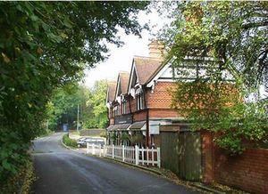
Warren Row is a hamlet of some sixty dwellings set on either side of a quiet country road bounded by bluebell woods to the south with open views stretching to the Chiltern Hills in the north. In the centre of the village is The Snooty Fox, a pleasant pub that acts as a centre for village socializing. St Paul’s Church (a late 19th century prefabricated mission church of the ‘Tin Tabernacle’ type) is an unusual building, erected in 1894 that is finished on the exterior in green corrugated iron. The village has some groups of pretty terraced cottages as well as larger detached properties. Many public footpaths radiate from the village, and to the north, is the working stud farm of Juddmonte. On the south side of the village is the entrance to a network of tunnels, used in WW2 as an underground factory producing aircraft components. Later, during the Cold War, it was maintained by the Ministry of Supply as a Regional Seat of Government. It is now a depository for a wine merchant and provides archiving storage for commercial clients. This rural community does not have the status of a Conservation Area but is typical of a quiet country village (of which there are only a few in east Berkshire) in need of protection from overdevelopment. |
Shottesbrooke Parish:
Shottesbrooke Park
|
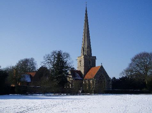
A private, old established rural park belonging to Shottesbrooke House (grade 2* listed, dating from the 16th century with later alterations), with St John the Baptist church (grade 1 listed, 14th century) adjacent and a collection of other buildings and structures (some also listed) that include the offices of the Landmark Trust. The parkland is mainly grass but with a small lake and several avenues of mature trees radiating from the house, as well as other considered planting. The grass is often grazed by sheep. The park is crossed by a bridleway (north to south) and a footpath (east to west) both of which have delightful views of the house and church and which understandably are popular. With public access at four separate points it is and has been regularly used by local people for walking, riding and cycling over many years. These connect to the extensive public rights of way network beyond the park. Although there is no known present threat to the character of the park, it being classed as an Area of Special Character should help ensure that any future developments are carefully considered with this wider role in the community in mind. |
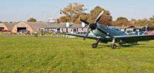
White Waltham Airfield
White Waltham Parish:
|
The airfield was the headquarters of Air Transport Auxiliary from February 1940 until 30th November 1945. It was from here that all the operational work needed to organise the task of ferrying RAF and RN warplanes between factories, maintenance units and front-line squadrons took place, i.e. all the planning and logistics needed to recruit and organise the activity of the 1,245 men and women from 25 countries who ferried a total of 309,000 aircraft of 147 different types, without radios, with no instrument flying instruction and at the mercy of the British weather. White Waltham is still widely regarded as the spiritual home of ATA. Consequently, any building still remaining on the airfield to represent this important heritage should be protected when considering development applications in accordance with our Policy 3 statement concerning the Airfield. The main clubhouse and administrative building (an original wartime structure), plus remaining original hangars, fall in this category. |
< Previous | ^ Top | Next >