
The many green spaces, both within and external to Eton and Eton Wick, are highly valued by the community. These areas notably include the Brocas, South Meadow, playing fields and a number of farms and riverside areas of natural beauty. It is the intention of the Neighbourhood Plan to preserve and to enhance these outdoor spaces so that future generations may benefit from the environmental and amenity value they provide.
The neighbourhood area is surrounded by quality green spaces; however, much of this is grassland or farmland and high biodiversity in a landscape like this is dependent on a wide variety of species in hedgerows and the trees with continuance to allow free movement of species. The countryside surrounding Eton and Eton Wick is identified in the Landscape Character Assessment for the Royal Borough (2004) as being Settled Farmed Flood Plain, including the following features:
There has been considerable neglect over the last 40 years of the field boundary hedgerows with many species growing out into trees with a loss of the under-storey. This has led to the loss of suitable habitat for nesting birds and of species requiring cover. A small amount of enhancement of some hedgerows by adjacent planting has taken place. Little or no work has been done to encourage rejuvenation of the ancient hedgerow plantings. It is critical that rejuvenation and on-going maintenance of hedgerows takes place and if at all possible should be linked by conditions to planning applications.
Much of the housing within Eton Wick has gardens both back and front and some roads have wide verges which are tree planted. Although there may be some areas of restricted travel for species the distance between green areas and trees is minimal. This should be continued and enhanced wherever possible. The western boundary of Eton Wick adjoins Dorney Common an open expanse of grassland with only hedgerows on its boundaries.
Similarly the housing areas either side of Royal Windsor Way at the boundary of Eton and Eton Wick have gardens and tree planting encouraging free movement of species and biodiversity and again enhancement should be encouraged. The linking of these to the main areas of Eton Wick and Eton is mainly by historic hedgerows and fields.
Eton College has many green spaces with considerable tree planting between its buildings. The only area lacking is around the central area of Keate's Lane and Slough Road and along with the height of the buildings interrupts the free movement of species. The playing fields to the north-east although having some tree planting are mainly devoid of hedgerows or low planting except at the boundaries.
Eton town is very linear and the High Street creates a break in green space. The old brook and Barnes Pool in the north of the town give the only green connection between west and east. Church Close and the church yard bring green space in to the High Street from the west but then the link to gardens beyond is interrupted by the High Street and the tall buildings.
The free flow of species along the river corridor is also interrupted by built up areas on both banks with little green space or trees for some distance. The river corridor to the west of the town is meadow land until west of the Brocas then some forestation takes place for a short distance and includes what was the Bird Sanctuary which is now mainly neglected. To the west of Royal Windsor Way there is a return to meadowland and then farmland where along the bank there is some scrub.
Generally much work is needed to increase the quality of habitat through our area to increase biodiversity.
Flooding is also a major driver of the policies contained in this section. Eton has one of the eldest public sewerage systems in England, as such increasing the number of houses and commercial premises (particularly restaurants) can exacerbate sewer flooding which in turn has knock on effects for the wider natural and physical drainage systems in times of heavy rainfall. The policies in this section are aimed at addressing these issues and ensuring infrastructure is adequately reinforced or upgraded alongside new development, in addition to enhancements to the area's natural blue and green infrastructure.
The principal issues/opportunities identified during the consultation exercises for the Neighbourhood Plan are as follows:
The Town Council wishes to see trees and hedgerows retained and protected and for further trees to be planted to maintain our green town and village for future generations. Wood pasture and parkland and floodplain grazing marsh are significant features and habitats within the neighbourhood area.
At present, many public ways run alongside the venerable water courses and historic hedgerows. The community values these spaces as a recreational facility owing to their visual appeal and ecological biodiversity. In summary, the streams and historic hedges are seen by the community as essential to the character and environmental strength of the area.
EN1 - Biodiversity
There is strong evidence to support for preserving green corridors, very strong support for the protection of open spaces, and strong support for preserving hedgerows, meadows, woodland and waterways.
Eton Wick and Eton are fortunate to have many mature trees that help provide a green landscape for the environment. Many of the trees are protected by the Conservation Areas provisions or by tree preservation orders, but the Town Council is keen for ways to be found to maintain and enhance this essential feature of our area.
Introduction
Open spaces are important to the town and village environments. The principal green spaces in Eton are Common Land or Lammas Land and/or in close proximity to listed buildings, such that their inclusion as a Local Green Space Designation is not necessary. Consultation exercises have indicated that quality open and recreation spaces in Eton Wick are required to a greater degree than in Eton, which already has high quality community spaces in an area that is relatively built up.
The listed Local Green Spaces have been identified as important areas which contribute to the town and village feel, access to leisure spaces and are an asset for environmental reasons.
The following green spaces all contain important views that have been identified by local residents. Though these views do not qualify as Local Views according to best practice criteria, they have been identified by local residents as contributing an essential role to the character of Eton and Eton Wick and it is intended that the Local Green Space designation will serve to support these inner-village views. Pictures of key views accompany the detailed plans of these Local Green Spaces in Appendix 5.
It should be noted that there are other important green spaces across the Neighbourhood Plan. The Brocas, for example, plays a vital role in the community, successfully serving as open spaces for numerous leisure activities and preserving views to Windsor Castle from across the fields. However, many of these spaces already benefit from protections meaning that they do not need to be designated under the Local Green Space Designation.
EN2 - Local Green Space Designations
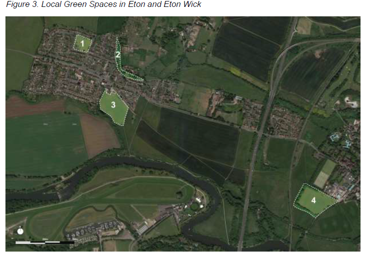
All of the identified green spaces are in close proximity to the communities of Eton and Eton Wick and none can be deemed extensive tracts of land. These Local Green Spaces have been identified as being demonstrably special for the following reasons:
1. The recreation ground at Stockdales Road / Colenorton Crescent - The green square and children's playground at Stockdales Road provides a valuable recreation and amenity space for residents living on the northeast side of the village.
2. Bell Lane and Common Road - There is a greenway connecting Bell Lane and Common Lane, running next to a local brook providing a tranquil and beautiful setting for contemplation, walking, running and cycling. This space has a high ecological value as it contains a number of mature trees and hosts a number of aquatic plants and vegetation due to the brook. Furthermore, the green space holds heritage significance as it contains a historic oak tree planted to celebrate the 60 years reign of Queen Victoria.
3. Eton Wick Recreation Ground (Haywards Mead) - Eton Wick Recreation Ground contains playing fields and is used for sporting and leisure events by a number of different community groups. It features a children's playground on the northern side of the green space.
4. Eton Recreation Ground on South Meadow Lane - The space is used for sporting and recreational activities and has Footpath 11 and a children's playground to its northern boundary. The space provides valuable local play space for young children, recreational space for walkers/dog walkers and facilities for local sports clubs.
Paragraph 76 of the NPPF encourages local communities to identify green areas for special protection that are of particular importance to them, through the development of a neighbourhood plan. By designating land as Local Green Space local communities are able to rule out new development other than in very special circumstances. Paragraph 77 of the NPPF states that the Local Green Space designation should only be used: where the green space is in reasonably close proximity to the community it serves; where the green area is demonstrably special to a local community and holds a particular local significance (e.g. because of its beauty, historic significance, recreational value, tranquillity or richness of its wildlife); and where the green area concerned is local in character and is not an extensive tract of land.
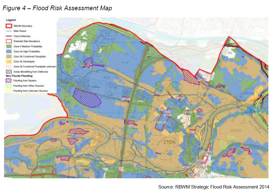
The majority of the Neighbourhood Plan area intersects with Flood Zones 2 or 3, and there is a significant risk that new development may be unsuitable or have a wider environmental impact. The Town Council is concerned to ensure that developers consider the net increase in water and waste water demand to serve their developments and also any impact the development may have off site further down the network, if no/low water pressure and internal/external sewage flooding of property are to be avoided. It will be important for Thames Water to be consulted as appropriate and developers are recommended to engage with Thames Water at the earliest opportunity. Thames Water must also be consulted regarding proposals involving building over or close to a public sewer. Developers should engage with Thames Water at the earliest opportunity.
Increases in maximum flood levels within adjoining properties could be achieved by ensuring (for example) that the existing building footprint is not increased, that overland flow routes are not truncated by buildings and/or infrastructure, or hydraulically linked compensatory flood storage is provided within the site (or upstream).
EN3 - Flooding
i. Development should not result in an increase in maximum flood levels within adjoining properties using mitigation appropriate to the site circumstances.
ii. The recreation of river corridors and wetland habitats in urban areas will be supported. This might comprise:-
- the design of site layouts; setting development back, allowing space for water, habitat, wildlife and recreation;
- reinstating the natural open waterway within existing culverted reaches of the river(s).
Both Eton and Eton Wick are prone to fluvial flooding (see Figure 4 overleaf). Some areas of Eton Wick also face significant danger from sewage flooding. The evidence in the SFRA highlights the severity of flood issues in the neighbourhood area. The recommendations contained within the SFRA are transposed as policy where applicable to respond to local flood risks and to help the area to adapt to a changing climate.
Alongside traffic congestion and heritage, flooding and sewerage concerns were most prominent from consultees. The community have a great understanding of the flood risks of living in Eton or Eton Wick, and have consistently attended consultation events reflecting these concerns. They have raised concerns about flooding and pollution, as well as the need to include flood mitigation measures in new buildings work across the Neighbourhood Plan.
< Previous | ^ Top | Next >