
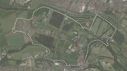
Figure 1 Map of Eton and Eton Wick designated Neighbourhood Plan boundary
Our neighbourhood has a unique and historic environment and comprises two settlements- the town of Eton and the village of Eton Wick. Eton has close links with Windsor and has the unique characteristic of hosting the world-famous institution for education, Eton College. Eton has a vibrant high street that serves local residents, visitors and tourists travelling to Windsor and Eton. Eton Wick, by contrast, is a predominantly residential settlement surrounded by farmland- indeed, wick means farm in Old English.
Eton College comprises much of the north-eastern boundary of our neighbourhood plan area, whilst the south and east are bound by the River Thames. To the north runs the Jubilee River and Dorney Common is situated to the west.
The town of Eton and the village of Eton Wick both have a small to moderate population size, which is slowly decreasing in contrast to the rest of the Borough and the UK. According to the 2001 and 2011 Census, Eton town has witnessed a significant population decline from an estimated 2,397 to 2,123. This is in stark contrast to the 7% average growth seen across the UK, and 8.2% growth in RBWM, over the same timescale.2 The population of Eton Wick has stayed largely static at 2,578 in 2001 and 2,569 residents in 2011.3 4
The demographics of our community vary in a number of ways. The similarities are that both Eton and Eton Wick have history, and there are many residents in both whose families have lived locally for several generations, although this has declined over time.
Eton features the unusual characteristic of accommodating an additional population of around 1,320 boys studying at Eton College for the duration of the school year, which runs from September to July with 3–4 week breaks at both Christmas and Easter. Eton College also accommodates approximately 350 teaching and support staff, together with their families, in Eton and Eton Wick. This equates to approximately 1,000 people resident in Eton and Eton Wick during term time (taking account of family members), dropping to around 300 outside of term time.
The significance of the College as both a local source of employment and an internationally renowned institution has its own effect on the local economy. For example, during the summer months, Eton features a high number of tourists.
According to the 2011 Census, Eton comprises 617 dwellings, whilst Eton Wick has 1,128 dwellings. This number may have increased slightly due to new homes created between March 2011 and March 2015.
The buildings in both the town and the village are predominantly built of brick and roofed in tiles and slate. A large proportion of buildings have heritage value within the neighbourhood area, particularly in Eton. For example, there are 132 buildings designated as either ‘listed’ or ‘significant not listed’ – a notable figure given that there are only 617 dwellings in the town. Eton is within a designated Conservation Area.
Conserving and protecting the heritage features in and around Eton and Eton Wick are extremely important. Eton’s historic character is supported primarily by the presence of Eton College and the High Street, which has medieval origins. Eton Wick hosts a number of heritage terrace streets and is home to a few historic landmarks, such as an oak tree planted to celebrate Queen Victoria’s 60th birthday. In both Eton and Eton Wick there are also a number of buildings which, although not listed, remain locally significant owing to their contribution to the historical character across the Neighbourhood Plan area. Both Eton and Eton Wick are united in their relationship with the wider countryside, which contains historic farmland and offers scenic views to landmarks such as Eton College Chapel, the Brunel Railway Bridge, and Windsor Castle, which is a Scheduled Monument.
The groupings of homes, local farms, open spaces, and linking lanes and footpaths have facilitated people movement within and across each community for centuries. As a consequence, Eton and Eton Wick are very friendly settlements, and the community wishes to preserve this amenable relationship over the Neighbourhood Plan period and beyond.
The policies in our Neighbourhood Plan need to be in general conformity with the strategic policies set out in the Royal Borough of Windsor and Maidenhead (RBWM) Local Plan and have regard to the National Planning Policy Framework (NPPF).
Our Plan considers the following strategic factors as critical to our town and village:
Housing growth in the Neighbourhood Plan area will be concentrated in the main communities of Eton and Eton Wick. In Eton Wick, there may be opportunities for housing development on the fringes of the village. In Eton, there are more limited opportunities other than infill, as expansion of the town has been constrained by the river, Lammas land and Eton College. The area between Eton and Eton Wick has offered some land for development in recent years near the A332 flyover. Both areas are constrained by flood risk, conservation requirements and the extensive Lammas and Common Land designations.
This Plan endeavours to promote the following principles to the period to 2036, so that Eton and Eton Wick may both be maintained as successful, friendly and sustainable settlements for future residents and visitors in the years to come. In particular:
A vital element of producing the Neighbourhood Plan has been the gathering, collecting and use of data and evidence. Wherever possible, the Steering Group has worked with RBWM to collate accurate sources of data and to establish facts and expert knowledge.
In addition to statistics, the Steering Group has committed to frequent dialogue and regular consultations with the communities and stakeholders across the Neighbourhood Plan area including residents, local traders, councillors, RBWM, and Eton College. Area-wide consultation events for Eton and Eton Wick were conducted during Autumn 2014, Autumn 2015 and Autumn 2016 (pre-submission consultation that ran for 7 weeks under Regulation 14 of The Neighbourhood Planning (General) Regulations 2012). Details of all consultations that have fed into this plan’s production are contained in the accompanying Consultation Statement.
It is a requirement of Neighbourhood Plans that they contribute towards the achievement of sustainable development. Our adopted definition of sustainable development is that “which meets the needs of the present without compromising the ability of future generations to meet their own needs.”
The Plan should seek proportionate and appropriate opportunities to meet the development needs of our area by promoting sustainable development:
2 It is worth noting that some of the decrease in population in Eton town may be explained by changing methodologies regarding how boarding students are registered in the census. Census statistics show that there is a significantly larger population of under 18s in the 2001 census compared to the 2011 census, suggesting that it might be the case that more Eton college boys have registered at their parent or guardian home rather than at the college.
3 These figures use the ONS Ward Geography to determine the population for the entire area, and the following 2011 Output Area geographies to indicate the statistics for Eton Wick: Windsor and Maidenhead 010C, Windsor and Maidenhead 010D, E00083648.
4 Also see historical population of 3984 in 1887: Eton, town and par., on S. border of Bucks, on left bank of river Thames, opposite Windsor (with which it is connected by a bridge), and 21 miles SW. of London -- par., 786 ac. (23 water), pop. 3984; town, pop. 3464; P.O., T.O. (Bartholomew Gazetteer of the British Isles (1887).
5 Lands or meadows held in severalty during the crop-raising period but subject to rights of common at other times (as for pasturage). Such rights sometimes had the effect of preventing enclosure and building development on agricultural land.
< Previous | ^ Top | Next >