
7.1 With its location on the River Thames, coupled with its rich heritage including the attractive area in the heart of the village, there are many views and vistas which are part of what defines the character of Datchet.
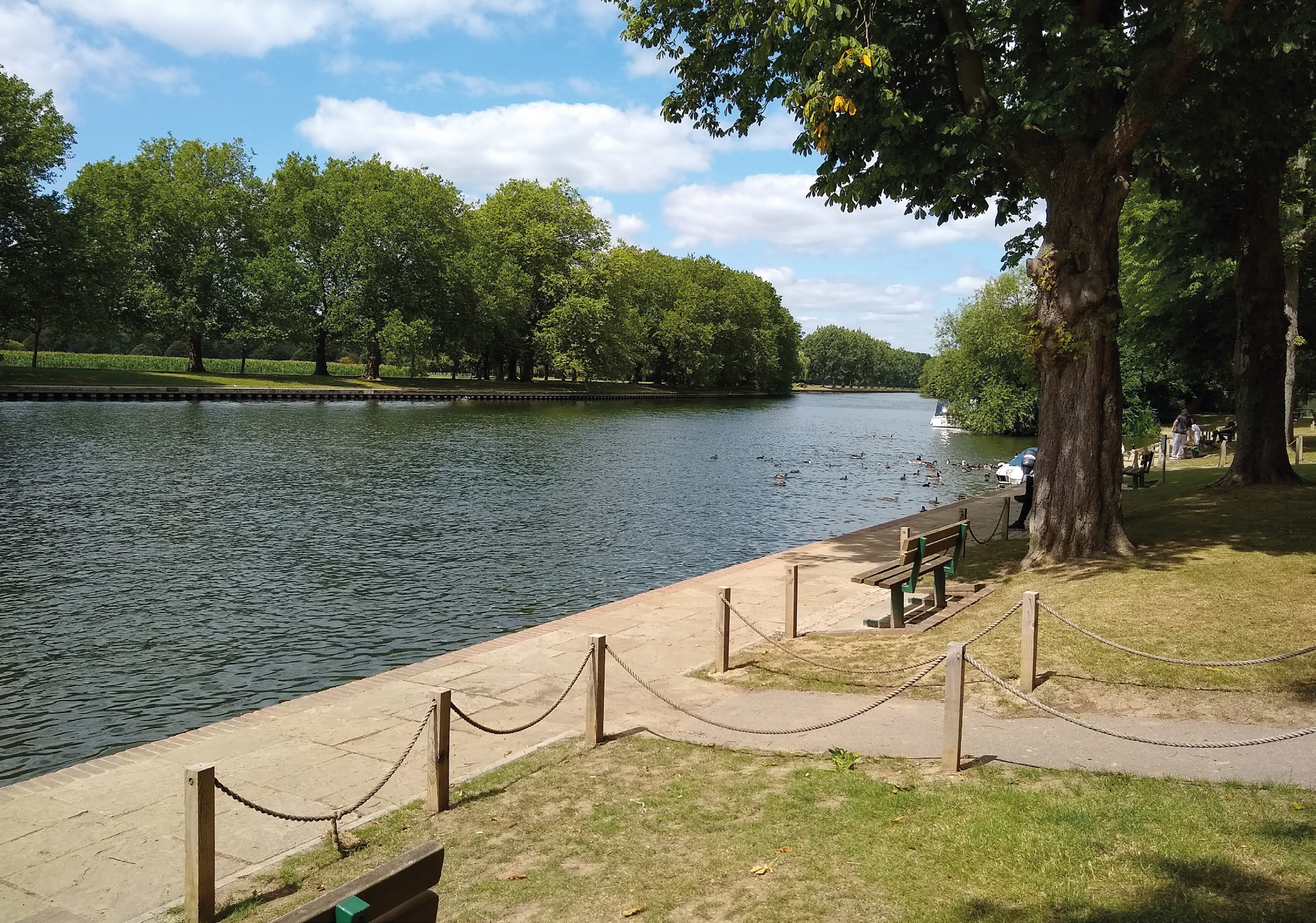
7.2 There is an element of surprise to the river views in Datchet. Although the village is situated beside the Thames, the river is mostly hidden from public view behind fences, hedges and tree-lined curtilages of private riverside gardens. Even along the Thames Path, on the outskirts of the village, views of the river are mainly short and narrow, restricted or obscured by dense trees and undergrowth. Nevertheless, it is important that such views for those using the Thames Path are respected, are improved where possible and are not adversely impacted by riverside development. Moreover, the limited views of the Thames mean that the importance of the views from the public Riverside Garden cannot be under-estimated.
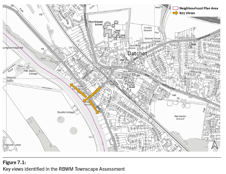
7.3 The RBWM Townscape Assessment 201016 identified these key views both up- and down-river as well as the view to the Riverside from the High Street (see Figure 7.1). The view out to the expansive Home Park, which has remained little altered from the early 17th century when it was the public route from Datchet to Windsor, is also mentioned in the Datchet Conservation Area Statement17. Glimpses of the tree-lined route can still be seen. RBWM Borough Local Plan Policy QP3 requires that development ‘retains important local views of historic buildings or features and makes the most of opportunities to improve views wherever possible (including views of key landmarks such as Windsor Castle, Eton College and the River Thames)’. Policy DAT5 seeks to ensure that these and other views along the Thames Path — no matter how small — are protected from harm.
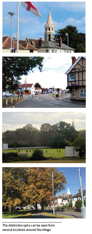
7.4 One specific landmark identified in the Townscape Assessment and Conservation Area Statement is the spire of St Mary’s Church. Its distinctive octagonal broach spire can be seen from several locations around the village and beyond. It is the only structure in Datchet which stands out above the treeline and can be seen from as far away as the Queen Mother Reservoir and the Copper Horse high point in Windsor Great Park. It is important that views of the spire are protected from harm.
POLICY DAT5: VIEWS
A. It is expected that development proposals will be designed so that they do not have a significant adverse impact on views along the River Thames from any footpath, cyclepath or public right of way. In particular, views identified in the Royal Borough of Windsor & Maidenhead Townscape Assessment 2010 (or successor document) are expected to be respected.
B. Development is expected to conserve the setting of St Mary’s Church and proposals are required to consider the impact on the view to the church spire and ensure that it does not have a significantly detrimental impact.
7.5 Datchet is home to three Local Wildlife Sites which are of importance for a range of wildlife habitats (see Figure 7.2). Two of these are areas that give waterside access and both have seen significant levels of commercial activity which has sought to take advantage of this access. However, there are significant concerns that such activities and the increased human presence is harming the wildlife in these Local Wildlife Sites. Development to expand commercial leisure activities is being proposed in these locations. What is certain is that this will result in more human activity and therefore disturbance of wildlife.
7.6 It is important that the Local Wildlife Sites are protected. As well as seeking to ensure that development minimises its impact on wildlife, national policy is clear in establishing that development has a role to enhance the natural environment by providing net gains for biodiversity (see also Policy DAT8).
POLICY DAT6: BIODIVERSITY
Development impacting on Datchet Common and Gravel Pits, and-or Queen Mother Reservoir Local Wildlife Sites must enhance biodiversity and must not result in any significant harm.
7.7 Under the NPPF, Neighbourhood Plans have the opportunity to designate Local Green Spaces which are of particular importance to them. This will afford protection from development other than in very special circumstances. Paragraph 100 of the NPPF says that the Local Green Space designation should only be used where the green space is:
7.8 The following five areas (shown on Figure 7.3) are considered to fulfil all of the criteria of the NPPF:
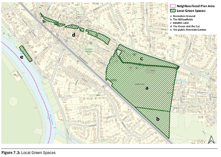
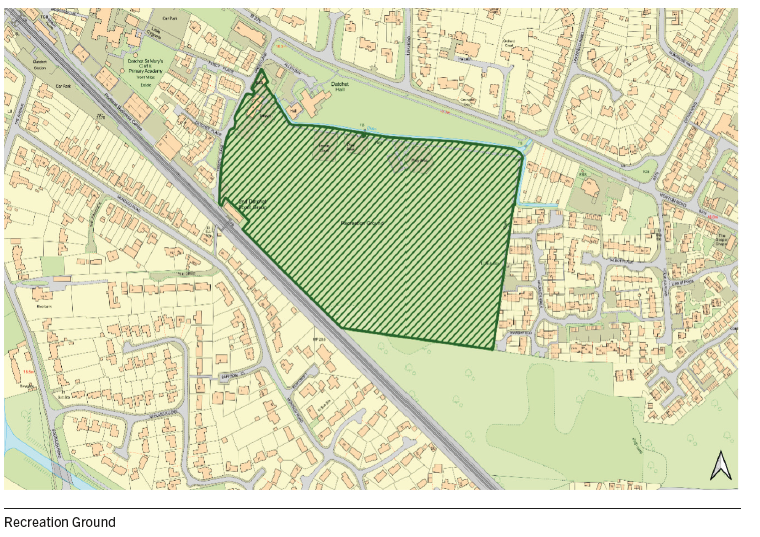
7.9 At 6.37 hectares, the Recreation Ground, or ‘Rec’, is the largest green space in the heart of the village and an important public leisure amenity. It has great recreational value for the community. It is separated from the Sabatini Land by a ditch which runs along its length.
7.10 The Rec has a NEAP (Neighbourhood Equipped Area for Play) for play and informal recreation with provision for children and young people that is rated good. There is a junior play area for the under 10s and a senior play area for 10s and over. The latter has recently undergone an extensive refurbishment programme. There are wooden tables and benches and other items of play equipment in the grass area between these two sites.
7.11 Sports facilities include two tennis courts, basketball court, two full-size football pitches and a Green Gym (outdoor exercise equipment). There are changing rooms, used by the football teams, in the Village Hall complex.
7.12 The space, which has some benches along its border with Green Lane, is also used for general exercise and is popular with dog-walkers. Large village events are sometimes held here as an alternative to The Green, including Royal Wedding celebrations in 2018.
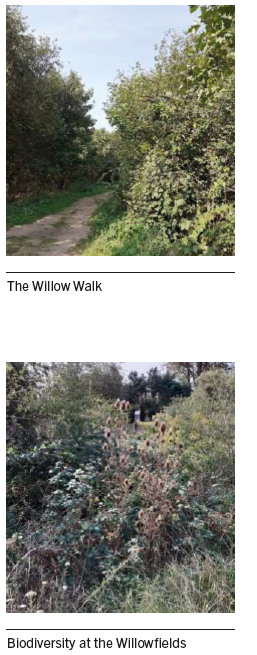
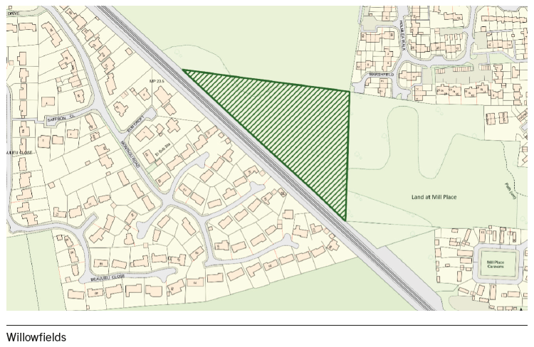
7.13 The Willowfields is 1.5 hectares of mixed shrub and woodland situated along the north side of the railway line to the south-east of the Datchet Rec. In the 1950s the present site and the land further east, the Land at Mill Place, were used for gravel extraction and the name is derived from the willow trees which grew around the gravel pit. Eventually the pit was used for landfill, which was capped with soil by the local authority and allowed to develop as a wild grassy area. Today it is used by people walking dogs and those wishing to explore a lesser known part of Datchet. It is increasingly being used by the local wildlife group, Wild About Datchet, for study and surveys of one of the few ‘natural’ areas in Datchet.
7.14 In contrast to the neatness of The Green with formal beds and planters of brightly coloured flowers, and the closely-cropped Rec, the Willowfields appear untidy. However the area has a different beauty which is being appreciated more today as local people seek to preserve habitats where wildlife and biodiversity can thrive.
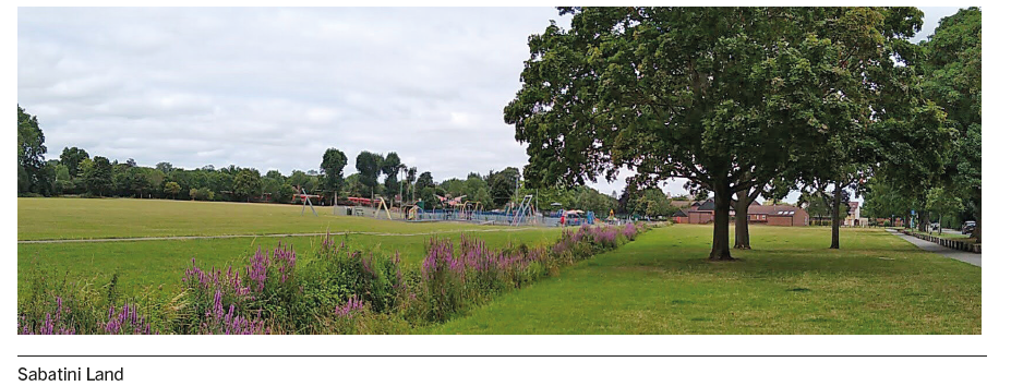
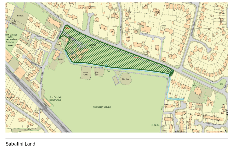
7.15 Located just east of the centre of Datchet, the Sabatini Land is a 1.4 hectare strip of well-tended grassland with some trees, to the north of the Recreation Ground. In the west is the Village Hall and other buildings. It is an important space that allows extensive views across the Recreation Ground and is an integral part of the character of that area. In addition it is an important space in its own right as it both facilitates the key cycle-/footpath which forms the link between east and west Datchet, and on approach from Horton it ‘sets the scene’ for the Conservation Area to the west.
7.16 It is an attractive setting for the Recreation Ground and, combined with the trees on the grass verge and the lovely mature trees in the gardens on the opposite side of the road, creates an avenue which forms a leafy gateway to the historic village. Views across the Recreation Ground are significant and highlight the ‘ring’ of tall trees which encircle it. From the north-east corner of the Sabatini Land there is a view of Windsor Castle.
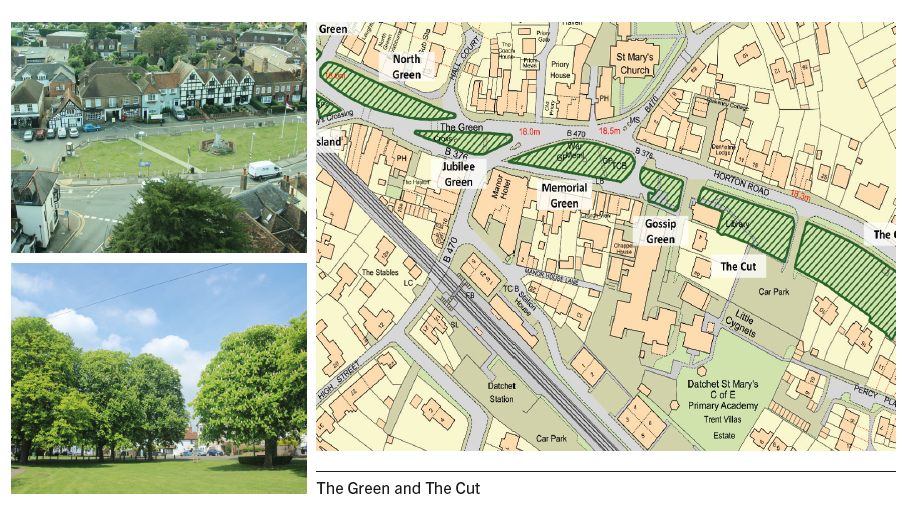
7.17 The Green is the most important open space in Datchet and forms the heart of the Conservation Area. Most of the historic and commercial buildings are clustered around it and major routes circumvent it. An area of 0.23 hectares, The Green is made up of separate areas laid to lawn and bordered with white posts and chains. The Green was gifted to the village by the Lord of the Manor in 1895. Grass verges at Hall Court and Slough Road also contribute to the green setting as do commemorative and ornamental trees while flowerbeds and planters add year-round colour to the space.
7.18 Apart from being the traditional centre of an English village, as a green core from where the residents can sit and observe the settlement’s finest buildings and watch the world go by, the purpose of The Green is the site of important village memorials and commemorative features as well as the location for village ceremonies and entertainments. In addition, around The Green and High Street are clustered most of Datchet’s shops and businesses.
7.19 It is a focus for community events such as the annual ‘Christmas on The Green’, a festive event with stalls, entertainment, food and drink to celebrate the lighting of the community Christmas tree; and ‘The Ellis Journey’, a re-enactment of the first recorded journey in a motor car, made in 1895 by Datchet resident, Evelyn Ellis, from Micheldever to his home in Datchet, which culminates with a display of veteran vehicles on The Green. National events such as Remembrance Day ceremonies and wreath-laying, and royal occasions are also traditionally commemorated and celebrated here.
7.20 The Cut is a strip of open grassland, about 0.3 hectares, with a double row of trees and park benches, which borders Horton Road and forms a green link between the Recreation Ground and The Green in the historic centre. It was also gifted to the village by the Lord of the Manor and is used by walkers, joggers, shoppers, pram-pushers, families on the school run, and cyclists. Some like to just sit on the benches. It is attractive and encourages pedestrians to walk across it to the Village Hall, Health Centre and Recreation Ground in one direction, and the village centre in the other. The pathways are also accessible to wheelchair users, linking The Green and the Sabatini Land.
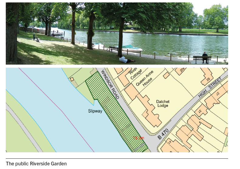
7.21 The public Riverside Garden is adjacent to the Windsor Road, B3021, where the road swings close to the north-east bank of the River Thames. It is a small area (about 0.17 hectares) of grass and trees which lies away from the village centre and sits between the privately-owned, fenced-off river gardens and a busy boatyard. Due to extensive ownership of the riverbanks, mainly by the Crown Estate, it is the only place in Datchet where the public have free access to the river and where the views are open and extensive. This gives it special status.
7.22 The Riverside Garden has recently been refurbished to create an attractive park with benches looking out over the river and a picnic area. Consequently it is very popular as a place where people go to sit, sunbathe, picnic and generally enjoy the views. Other regular users include anglers, kayakers, canoeists and paddleboarders, walkers from the Thames path, and families who go to feed the ducks. The value of this space was widely appreciated during the coronavirus pandemic when it was used more than ever.
POLICY DAT7: LOCAL GREEN SPACES
A. The following spaces as shown on the Policies Map are designated as Local Green Spaces:
B. The management of development within areas of Local Green Space will be consistent with that for development within Green Belts, as set out in national policy.
7.23 National planning guidance requires development to achieve net biodiversity gain. The Environment Act 2021 requires all development to deliver a minimum uplift of 10% in the amount of biodiversity. In practice this is challenging, highlighting firstly the importance of retaining the biodiversity assets on the site if at all possible. Mature trees and hedgerows are significant biodiversity assets and therefore their retention is a vital part of this. Equally, new planting and the creation of new habitats needs to be carefully planned. In order to achieve biodiversity net gains — with the associated benefits for wildlife and reducing the impacts of development on climate change — all opportunities large and small need to be embraced.
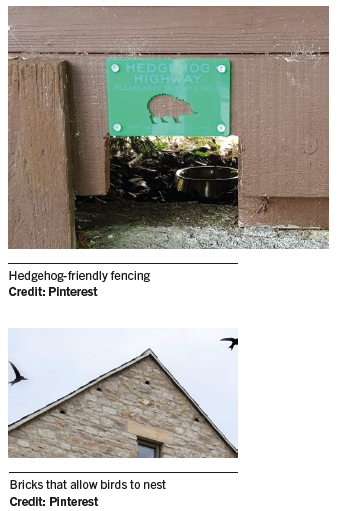
7.24 The design of individual buildings and of neighbourhood-scale green and open spaces, including private gardens, will help to ensure that the species present in Datchet can thrive. Examples of the simple, small scale but positive solutions that well-thought-out design can easily incorporate are:
POLICY DAT8: PROVISION FOR WILDLIFE IN NEW DEVELOPMENT
All development proposals are expected to deliver net biodiversity gains in addition to protecting existing habitats and species. Development proposals (particularly residential developments) which seek to address this requirement on site (in part or in full) by incorporating design features that encourage local wildlife to thrive, will be strongly supported.
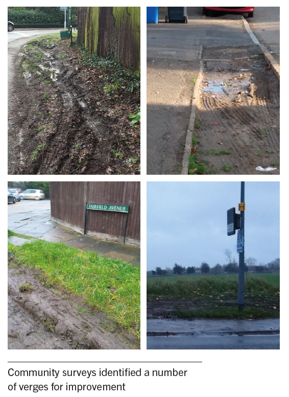
7.25 Generous grass verges to roadways and tree-lined streets are a key characteristic of Datchet. In built-up areas, the value of green verges to biodiversity is significant. Equally, such verges are all too often lost to parking, particularly where they are wide verges and cars can park entirely off-road. This results in significant degradation of the verge, loss of wildlife or loss of the opportunity for species-rich planting.
7.26 Policy NR2 of the Borough Local Plan recognises the role that verges play and requires development proposals to protect and enhance biodiversity by measures to ‘recognise the importance of … green verges’. This is supported but it is considered that in Datchet, where parking on verges and their subsequent degradation is considerable, there needs to be a more explicit policy requirement to protect and enhance verges.
7.27 The Neighbourhood Plan community surveys identified a number of verges for improvement. These include those along and off Slough Road, Horton Road, London Road, Majors Farm Road, Montrose Avenue, Montagu Road, The Avenue, Windsor Road and Ditton Road.
POLICY DAT9: ROADWAY VERGES
A. Green verges along roadways should be retained. Development should seek to provide new grass verges where possible. These should be designed to prevent degradation, for example, by preventing vehicles from driving over them or from using them for parking.
B. The protection and-/or enhancement, including biodiversity enhancement, of existing grass verges will be supported.
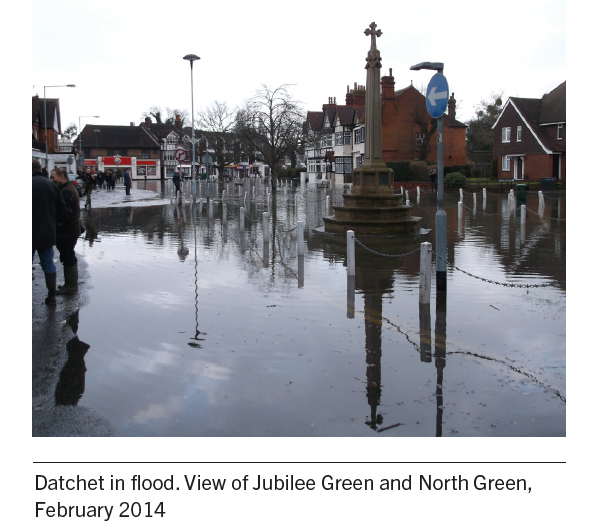
7.28 Flooding is one of the topics raised most frequently by residents during consultation. Events in recent years, including widespread flooding in 2014 which affected a large number of homes and businesses, have highlighted the extent of the threat that the community lives with. There are four designated main rivers in Datchet, all with the potential to flood. These are the Thames and Jubilee rivers, the Myrke stream and the Datchet Common Brook. In addition there is an extensive latticework of smaller watercourses, drains and ditches. An estimated 80-85% of Datchet is designated as Flood Zones 2 and 3 and there is significant concern that new development would increase the number of people at risk.
7.29 It is imperative that any new development does everything that it possibly can to actively reduce flood level risk in Datchet, principally by locating development away from areas of high flood risk. The National Planning Policy Framework 2021 (paragraph 166) states that, when determining any planning applications, local planning authorities should ensure that flood risk is not increased elsewhere — this includes adjoining properties. Where appropriate, applications should be supported by a site-specific flood-risk assessment. Development should only be allowed in areas at risk of flooding where, in the light of this assessment (and the sequential and exception tests, as applicable), it can be demonstrated that development is flood resistant and resilient and risks can be managed, including appropriate emergency planning.
7.30 According to The Woodland Trust, the importance of natural processes in flood defence is increasingly recognised. When combined with other flood defences, trees provide a sustainable and low maintenance solution to lessening the risk of flooding as well as delivering other environmental and economic benefits. Retaining and planting trees can be effective in increasing water infiltration and reducing and slowing surface-water runoff18.
7.31 Due to its geology, Datchet is prone to groundwater flooding as well as fluvial and surface water flooding. This is due to the high water table and can mean that traditional sustainable drainage systems (SuDS), provided as part of new development, are ineffective. Susdrain reports that locations with high groundwater levels are not only susceptible to flooding but may also damage deep SuDS components. It states,
“If the surface of an infiltration system is too close to the water table (i.e. normally less than 1 m), a rise in water levels during particularly wet periods could cause groundwater to enter the infiltration system, reducing the amount of storage available, it could also cause floating of storage tanks. Groundwater must also be protected from contamination and pollutants19.”
7.32 Susdrain recommends that in such locations, SuDS solutions need to focus on surface and shallow features to avoid infiltration. This could include kerb drains. Some SuDS components (e.g. permeable pavement, swales etc.) that usually allow infiltration may possibly still be suitable if used in conjunction with an impermeable liner (such as a waterproof membrane or compacted native clay) to prevent infiltration.
7.33 The Borough Local Plan Policy NR1 (Managing flood risk and waterways) requires development proposals to ‘be constructed with adequate flood resilience and resistance measures suitable for the lifetime of the development’. Following engagement with the Environment Agency, a number of recommendations for building design to achieve this were identified:
7.34 In planning for the provision of appropriate flood attenuation measures, applications are encouraged to take account of good practice advice, including the ‘Property Flood Resilience Measures’ guidance prepared by CIRIA20 and guidance from the Environment Agency21.
7.35 There are still cess pits in Horton Road to the east of Mill Place and the Thames Water site. In the 2014 floods, some sewers overflowed.
7.36 Drainage schemes proposed to support new development should protect people and property on the development site from flooding and should not create an additional risk from flooding outside the development or have a detrimental impact on surface water run-off and sewage discharge networks in the village.
7.37 It is the responsibility of a developer to make proper provision for surface water drainage to ground, watercourses or surface water sewer. It must not be allowed to drain to the foul sewer, as this is the major contributor to sewer flooding.
7.38 There are two bunds in Datchet that were constructed to act as a flood defence mechanism — Sumptermead and Southlea bunds (see Appendix C). Both are in private ownership and it is the responsibility of the riparian owners to maintain them. Bunds can perform an important function to reduce the worst effects of fluvial flooding. They are most effective when used in conjunction with other flood alleviation measures and when it can be ensured that their use does not increase flood risk elsewhere, by moving the risk of flooding from one site to another.
7.39 Whilst responsibility for their maintenance as effective flood risk measures is determined by the individual deed of covenant for each bund, the continuing use and maintenance of bunds is supported by the Datchet Neighbourhood Plan.
7.40 Despite the prevalence of water in and around Datchet, it is a precious resource that needs to be used efficiently. Climate change is placing increased pressure on water resources due to the increased incidence of drought during our summers. Development should therefore be designed to be water efficient and reduce water consumption. Building regulations require this to be enforced by way of a condition22.
POLICY DAT10: FLOODING DRAINAGE AND WATER EFFICIENCY
7.41 A survey on renewable energy and design matters undertaken to inform the Neighbourhood Plan identified very high support for improvements to the environmental efficiency of building.
7.42 The Climate Change Act 2008 committed the UK to an 80% reduction in CO2 emissions by 2050. In June 2019, an announcement was made by Government to reduce this further to almost 100% by 2050. This will be a major task that will require everyone to be engaged, from households and communities, to businesses and local and national government.
7.43 In 2016, the residential sector alone accounted for over 16% of the UK’s annual greenhouse gas emissions (source: Department for Business, Energy & Industrial Strategy). The total emissions from all building types will therefore be much greater. Standards for ecologically sustainable homes and developments are now optional23.
7.44 It is vital that new homes and other buildings are built to the highest possible standards and are designed in a way that minimises their carbon footprint. This not only means that they should be exceptionally well insulated, but they must have low water demand (and maximise use of grey water) and maximise renewable sources in the provision of their energy. Policy SP2 of the Borough Local Plan requires development to incorporate measures to adapt to and mitigate climate change. It therefore covers these issues and is supported by RBWM's Sustainable Design and Construction Supplementary Planning Document (SPD)24.
7.45 This is supported by the Neighbourhood Plan and development is encouraged to go as far as it can to minimise the impact of development on the environment and climate. In particular, development of the land at Riding Court Road and London Road allocated in the Borough Local Plan (Policy ref AL39) is encouraged to install sustainable alternative heating methods rather than gas boilers.
“It is vital that new homes and other buildings are designed in a way that minimises their carbon footprint.”
7.46 New development is required to provide a minimum 10% net gain in biodiversity and, where this is not possible, to make contributions towards offsetting biodiversity actions. Such actions could be used in any part of the borough, therefore it is important that opportunities to improve local biodiversity are identified. The following list identifies such opportunities in Datchet.
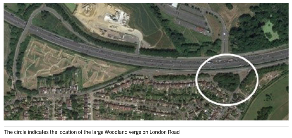
7.47 Near the junction of London Road and Ditton Road, there is a semi-derelict roadside strip of woodland, an outlier of Ditton Park Woods (see aerial view below). Before the M4 was built, Ditton Road used to lead to Ditton (listed house and garden). This wooded area is used by delivery drivers in need of a ‘comfort break’; it suffers from fly-tipping and has been the location of serious criminal activity. There is much scope for improvement and potential to enhance biodiversity.
7.48 In 2018 Datchet Parish Council applied for a Greater West biodiversity off-setting grant from Network Rail. A plan was drawn up with the help of the Berks, Bucks and Oxfordshire Wildlife Trusts to improve the areas alongside the railway (at the back of the Recreation Ground and at Willowfields and the Land at Mill Place). The bid was unsuccessful but the plan still exists for improving and enhancing the area. The railway line is also identified in the RBWM Green and Blue Infrastructure Study as an opportunity to protect and enhance it as an ecological corridor.
7.49 The stream which is culverted under The Green, known locally as the Barrel Arch, runs into the Recreation Ground Ditch. This joins the Linchfield Brook (also culverted) and the Datchet Common Brook (designated main river) which runs into the Thames. There have been some initial investigations and plans drawn up for how the Recreation Ground Ditch area could be improved with planting to support biodiversity. Wild About Datchet has surveyed the wildflowers in the ditch.
7.50 There is a small section of the Jubilee River (Thames flood relief scheme) in Datchet. The area is identified by the Thames Valley Environmental Records Centre as part of the Bray to Eton Pits and Meadows Biodiversity Opportunity Area with substantial opportunities to make positive changes for biodiversity. It comprises a mixture of uncultivated grassland, scrub, hedgerows and woodland. The Jubilee River runs through it as does the Myrke Stream, and the river margins are populated by water-loving plants. Common river species from stickleback to pike are present in the Jubilee River and there are screens on weirs to protect eels. Previous surveys indicate that the site was rich in ornithological life and small mammals such as shrew, otters and water vole. Their current status is unknown, for example, water voles are threatened by a growing mink population and American Signal Crabs may have eradicated native crayfish. Larger mammals such as Muntjac, Roe and Fallow deer transit through.
7.51 The area provides access to nature for the wellbeing and enjoyment of residents. It is quiet and traffic-free with an adopted cycle path, also used as a footpath, running through it. This is used to connect with the Sustrans National Cycle Network, the Thames Path and other footpaths. It is also used as a pedestrian shortcut between Slough Road and Pococks Lane.
7.52 The Myrke Stream is generally overgrown and strewn with rubbish which is detrimental to the health of local wildlife. Better land management would improve the habitat for certain species.
7.53 When the Jubilee River was constructed, the Environment Agency took responsibility for restoring and maintaining the surrounding land. However, its 25-year ecological maintenance plan was abandoned several years ago due to funding issues and responsibility was handed back to landowners and the local authorities. With the assistance of appropriate surveys, there is potential to further enhance the river margins and grassland areas by creating additional wildlife habitats and improving biodiversity.
7.54 As of 2020, Channel 1 of the proposed River Thames Scheme from Datchet to Teddington is not going ahead due to lack of funding. However, the Environment Agency and Surrey County Council intend to build Channels 2 and 3 in such a way that Channel 1 could be added at a later date. The RBWM Borough Local Plan proposes to safeguard the route for Channel 1 for this purpose. The Environment Agency has stated that this will not put Datchet at greater risk of flooding. Proposals in respect of the River Thames Scheme are therefore supported in principle. Local flood defences to protect Datchet are being considered in conjunction with the Environment Agency as are the repair and improvement of existing defences. No timescale is available for these at present as options are being developed but any additional or improved defences should provide permanent, long-term solutions and protection.
16 LUC (2010) RBWM Townscape Assessment, for the Royal Borough of Windsor and Maidenhead
17 RBWM (1995) Conservation Area Statement: Datchet
18 https://www.woodlandtrust.org.uk/media/1794/stemming-the-flow-trees-in-flood-protection.pdf.
19 www.susdrain.org/files/resources/fact_sheets/site_challenges_for_designing_suds_v4.pdf.
20 https://www.ciria.org/Resources/Free_publications/CoP_for_PFR_resource.aspx.
21 https://environmentagency.blog.gov.uk/2016/11/11/make-your-home-more-flood-resilient.
22 https://thebuildingregulations.org.uk/guides/Part_G/Section_G2_Water_efficiency.
23 The Code for Sustainable Homes was withdrawn by the Government in 2015 and this has been replaced by national technical standards, which include optional Building Regulations standards regarding water and access as well as a national space standard (this is in addition to the existing mandatory Building Regulations)
< Previous | ^ Top | Next >