
6.1.1 A key objective of planning is to maintain and where possible enhance the quality of a place. This quality is not only about how an area looks, but also about how it feels and is used. The quality of an area is important to the social, economic and environmental vitality of its community, and is often important beyond the immediate vicinity. These factors make it important to ensure that the qualities of our towns, villages, hamlets, spaces, and countryside are maintained and enhanced, and that new development contributes to these values.
6.1.2 Development can help build community cohesion, define local distinctiveness, and foster a sense of place, or conversely it can harm these assets by not considering fully the impacts or opportunities within a scheme or proposal. Development should be a long-lasting feature within an area, so it is important to get it right.
6.2.1 The Government has identified in the National Planning Policy Framework (NPPF) that the main purpose of planning is to contribute to the achievement of sustainable development by:
6.2.2 The Council is committed to supporting in full, the growth anticipated to occur in the Borough over the 20 year plan period to 2033. It is also committed to achieving a sustainable balance between meeting growth needs and the creation of high quality, well-functioning places with distinctive local identities. Delivering this balance is at the heart of placemaking.
6.2.3 As a place the Royal Borough is defined by its varied mix of towns and villages set in an attractive rural landscape of pasture, forests, Royal parkland and water bodies. The unique and long association with the Crown has left the Borough with many exceptional buildings and places and a rich portfolio of heritage assets, whilst the River Thames and the large number of trees and open spaces create a green character to the Borough as a whole. Together these features create a unique identity for the Borough based on its Royal connections, heritage legacy and attractive, high quality and green places.
6.2.4 Within this wider place context are a series of smaller communities and places, each with its own distinctive character and unique identity. Work undertaken by communities through Neighbourhood planning processes has helped to refine understanding of some of the areas of the Borough and the qualities that make these smaller places unique and distinct. This work can further inform site development briefs through Neighbourhood Plans, to support local aspirations for future development proposals.
6.2.5 The driving principle for placemaking in the Royal Borough of Windsor and Maidenhead is to plan for the Borough as a whole place whilst also supporting placeshaping by local communities for the smaller places which together make up the entity of the Royal Borough.
6.2.6 As part of the placemaking process the Council will expect new growth to:
6.2.7 The broad approach to sustainability and placemaking at the local level is set out in the vision, objectives and spatial strategy of the BLP, with detail in subsequent policies.
6.2.8 In addition to the broad framework set out by the BLP, the Council will continue its sustainable placemaking through further work in the form of neighbourhood plans, the ongoing Infrastructure Delivery Plan, and Supplementary Planning Documents.
6.2.9 The Council will also work with landowners and developers to ensure ‘stakeholder masterplans’ are prepared for sites above the thresholds set out in Policy QP1(3). The stakeholder masterplanning process formalises good practice in relation to pre-application discussions, by requiring developers of larger sites to engage with the Council, local community and other stakeholders at an early stage in the development process.
6.2.10 The stakeholder masterplanning process and output should be proportionate to the scale of the proposed development, and likely complexity of the issues needing to be addressed. Larger, more complex proposals will require a more involved process, engaging a wider range of stakeholders and local interest groups; considering a wider range of issues and site options; and the final stakeholder masterplan document providing a fuller framework for the preparation and submission of the subsequent planning application.
6.2.11 The site promoter/developer will be responsible for preparing the stakeholder masterplan document. The main stages of the stakeholder masterplanning process will be engagement with the Council and other stakeholders on key issues, priorities and development options; preparation of the draft stakeholder masterplan document; consultation on the draft document; consideration of the consultation responses and preparation of final stakeholder masterplan document (with evidence of how the consultation comments have influenced its contents); and approval of the final stakeholder masterplan document by the Council.
6.2.12 The Council will work with site promoters/developers to agree the most appropriate scope and form for the stakeholder masterplan document, with a view to ensuring that the process adds value from a placemaking perspective.
6.2.13 'Stakeholder Masterplans' will not need to be prepared for sites that sit within one of the three placemaking areas (Maidenhead Town Centre, South West Maidenhead and Ascot), with the comparable pre-planning application engagement and consultation with local communities and other stakeholders being undertaken as part of the Supplementary Planning Document (SPD) process for these areas.
Policy QP1 Sustainability and Placemaking
|
6.4.1 Maidenhead has a compact town centre containing an evolving shopping, office, leisure and cultural offering. It is enclosed by major highways on its western and northern sides, the Great Western railway line to the south and on the eastern side its waterways. The presence of the railway station within the town centre, together with the major highways means that it is easily accessed (although this is not the case in respect of the provision of local pedestrian and cycle access). There are excellent green spaces just outside of the core retailing area and the waterways in the town centre also provide recreational opportunities.
6.4.2 Maidenhead has been identified as the key focus in the Borough for accommodating future development and the town centre area will play a major role in delivering the scale and mix of development types that the Borough requires. 12 of the Plan’s 40 allocated development sites lie in the town centre area delivering retail, employment, housing, leisure and community uses. The range of uses, scale of development, intensity of activity and large number of different sites makes it important that the future development of the town centre is considered holistically and compels the need for a bold vision of placemaking.
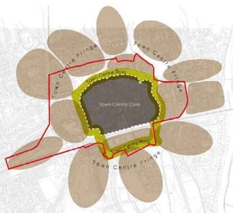
6.4.3 The comprehensive placemaking approach to the town centre has expanded the concept of the town centre beyond the traditional central retail focus. The Maidenhead Town Centre Placemaking Area (MTCPA) that this policy relates to encompasses a Town Centre Core, the Town Centre Ring and the Town Centre Fringe (as shown on Figure 2(2)). The MTCPA is encompassed within the Maidenhead strategic growth area (shown on the Key Diagram), and its full extent is included on the Policies Map. Improvements in each of the Core, Ring and Fringe areas must complement each other and into the wider surrounding areas of the Town, including the adjoining South West Maidenhead Placemaking Area.
Maidenhead Town Centre strategic placemaking map
6.4.4 This policy seeks the delivery of the MTCPA as a high quality, sustainable and vibrant heart for the town that is accessible, attractive and enticing. It sets out a series of placemaking principles to ensure a comprehensive, positive and proactive approach to the development of the allocated sites. It seeks to ensure that sustainable, green and innovative design solutions come forward that meet the Council’s transformation and regeneration ambitions for the town centre.
6.4.5 Maidenhead town centre is often characterised by the historic form, centred around the conservation area. This gives the town a distinctive historic environment. The retention and enhancement of this historic core is a key consideration for future development. Good contemporary design can be integrated to utilise the character of the area and enhance the distinctiveness.
6.4.6 All development in MTCPA will be required to provide high quality architectural and urban design. It will also be expected to extend, deepen and enhance the green and blue infrastructure networks across the town centre, linking into areas beyond.
6.4.7 The scale of development and the compact physical form of the town centre provide enhancement opportunities for intensification and high-density development. This includes potential for raising context heights in specific locations as well as tall building development in appropriate identified locations, outlined in greater detail in the Tall Building Study (2019). Increases in height will be expected to provide meaningful enhancement to character and distinctiveness and enable green infrastructure networks to extend upwards. The quality of tall buildings will be required to be exemplar.
6.4.8 Gateways into Maidenhead provide a main route into the town centre and are therefore important distinctive features. There is need to enhance these gateways and movement routes for all modes of transport to improve the overall permeability into the town centre. The historic gateway to the western end of the Historic Town Centre Core near the ring road is an example of a gateway that can be significantly enhanced whilst keeping the historic character.
6.4.9 New public realm development with high quality design help create landmarks and destinations to create a key characteristic. Opportunities for new public spaces must incorporate urban greening methods that are implemented into the existing green infrastructure network. Additionally, existing public spaces should take the opportunity to enhance the green infrastructure of the place, to respond to the challenges of climate change. Integrating biodiversity gain across the town centre core with links and connections in free infrastructure into and around the town centre improves the ecological function of the area, but also underpins the town’s identity as a green place, and its attractiveness as a place to enjoy. The waterways are also key contributors to biodiversity and place identity, which also provide recreational amenity. This will positively contribute to people’s health and wellbeing.
6.4.10 The Council, in partnership with the local community, landowners, developers and other stakeholders, will prepare a Maidenhead Town Centre Supplementary Planning Document (SPD) that will expand on the policy and provide a more detailed framework to guide new development in the town centre. It will ensure that there is a comprehensive and coordinated approach to delivery of the site allocations within the MTCPA as a whole (including in relation to infrastructure delivery). The SPD will draw on the Maidenhead Town Centre (MTC) Placemaking Study 2019 and a range of other evidence documents (including the Tall Buildings Study) as well as other placemaking work being undertaken, such as the Maidenhead Vision Charter.
Policy QP 1a QP1a Maidenhead Town Centre strategic placemaking area
Town Centre Core
Town Centre Ring
Town Centre Fringe
|
6.6.1 The South West Maidenhead Strategic Placemaking Area (SWMPA) is a large area of land to the south-west of Maidenhead railway station, extending from the railway line southwards to the M4. The land has a range of topographies and is currently used for a mix of open space, leisure, residential and employment activities. A number of key local roads into Maidenhead Town Centre run through the area which is well located in relation to the A404(M), A308(M) and the M4. Maidenhead town centre lies to the north of the area.
6.6.2 The area covered by the SWMPA is encompassed in the Maidenhead strategic growth area shown on the Key Diagram, and its full extent and component site allocations is included on the Policies Map.
6.6.3 This Plan proposes accommodating some 2,600 new homes in the SWMPA, together with a large employment site with scope to accommodate a range of uses with a mix and quality that meets the Borough’s needs and aspirations for commercial land. The Plan also allocates Braywick Park as a mixed use strategic green infrastructure space, accommodating indoor and outdoor sports facilities, a public park, special needs school and wildlife site.
6.6.4 This policy seeks the delivery of the SWMPA as a high quality, sustainable development area for Maidenhead and sets out a series of placemaking principles to ensure a comprehensive approach to the development of the allocated sites. The scale of development compels the need for a bold vision of placemaking and this can only emerge through a structured framework to ensure the necessary infrastructure, community needs and design objectives are met.
6.6.5 Given the importance and scale of the new development in the SWMPA, development proposals will be required to accord with a range of placeshaping principles. These principles will ensure that a comprehensive approach is taken to the development of the area as a whole which will bring together all of the component parts of a successful place.
6.6.6 The scale of development in this area provides an opportunity to deliver a high quality, sustainable development with a distinct character and degree of self-containment supported by the provision of on-site services and facilities including primary and secondary schools, a local centre; new and enhanced open spaces, community and health facilities.
6.6.7 Development in the SWMPA will need to address a number of issues including tackling congestion, improving connectivity both north-south and east-west through the area and into the surrounding town and local communities. The northern part of the SWMPA adjoins the Maidenhead Town Centre Air Quality Management Area (AQMA) and, as development in such close proximity to the AQMA may worsen emissions in the area, mitigation measures such as enhanced public transport routes, and opportunities for sustainable and active travel should be maximised to reduce negative impacts on air quality.
6.6.8 North-south connections are currently provided by the existing road corridors of Shoppenhangers and Braywick Roads although these corridors are constrained and, in their current form, present limited opportunities for accommodating bus or cycle lanes. Further to the south, the Triangle strategic employment site is separated from the new Desborough housing allocation by the strategic road network, which, if not addressed, would perpetuate the dominance of the private car for journeys between Desborough and future employment opportunities there. A new, car free green spine, running north-south through the heart of the SWMPA provides the opportunity to create a new public transport corridor, fast cycle links, safe pedestrian connections and an attractive variety of open space.
6.6.9 East-west connections from the South West Maidenhead Strategic Area (SWMSA) out to adjoining areas, especially Braywick Park and south-west to Ockwells are also currently limited, both for vehicular and non-vehicular modes as well as for wildlife and biodiversity. Measures to improve connectivity will therefore need to seek to increase opportunities for active travel and to enhance access to public transport.
6.6.10 In addition to the transport challenges, the scale of development and the transformation of the open space poses challenges for the retention and enhancement of green infrastructure to serve the new community and for the delivery of net gains in biodiversity. Furthermore, the current approach to Maidenhead from the south is characterised by green, leafy corridors. The challenge for the development of the SWMPA is to provide sufficient green infrastructure and accessible open space for the benefit of existing and new communities. Whilst on-site provision of open space and green infrastructure is important, the improvement and provision of new connections to areas of formal and informal open space elsewhere in the SWMPA area for pedestrians, cyclists and nature will be key to creating a healthy, sustainable community.
6.6.11 Areas in the southern half of the SWMPA fall within Flood Zones 2 and 3, including a small part of Desborough residential site and a large part of the Triangle strategic employment site. The majority of Ockwells open space either side of the channel of The Cut watercourse falls within Zone 3b and the Council will work with the Environment Agency to create backwaters in the river to enhance habitats for fish and other wildlife. The eastern part of Braywick Park lies within Zone 2.
6.6.12 Building at scale presents a range of opportunities, for example for modal shift, whereby the development of the SWMPA can encourage a movement towards lower car-ownership in those parts of the area that are well-served by public transport and by delivering services and facilities within walking distance of a large proportion of residents. The scale of development here also presents the opportunity for innovation in building types, incorporating green buildings and exploiting opportunities for low carbon lifestyles.
Vision SWMPA will be an area that fulfils a variety of roles for both the local area and Maidenhead as a whole. The provision of infrastructure and other functions will contribute in a number of ways to a more sustainable, more distinctive and more desirable part of town. A sense of place and distinctiveness will emerge in different ways across the SWMPA. Maidenhead is renowned for being a green town with leafy approaches benefitting from the rich landscape backdrop of the Thames valley to the east and north, the Chilterns margins to the north-west and wider open countryside to the west and south. Retaining the existing trees and landscape buffers along the strategic road corridors at the southern end of the SWMPA will maintain the sense of leafy enclosure and new residents will benefit from improved access to and integration with the significant green spaces of Ockwells Park and Braywick Park as well as new and improved blue infrastructure. New and existing communities alike will live a greener existence among a flourishing network of green streets and spaces which will accommodate biodiversity and people harmoniously. In 2019 the Council committed the Royal Borough of Windsor and Maidenhead to become carbon neutral by 2050. This challenging commitment will require a proactive approach by many parties, including the residents of Maidenhead. As new communities become established, more sustainable patterns of living will become enshrined to enable new residents to instinctively choose to reduce their environmental impact. The choice to live in South West Maidenhead will be a choice to live more sustainably and with this will come the opportunity to live better, more sociable, more connected and healthier lives. |
Framework Plan
6.6.13 New development within the area should come forward in accordance with the South West Maidenhead (SWM) Placemaking Area Framework Plan, which provides a high level planning context to guide and enable a comprehensive approach to be taken to the future change and evolution of the area in a subsequent Supplementary Planning Document (SPD) and planning applications.
6.6.14 The Framework Plan illustrates key guiding principles and broad land use distributions across the area and assists in articulating and interpreting some of the key elements of the policy, including:
6.6.15 The Council will work with the landowners, developers, stakeholders and other interested parties to prepare the SWM Development Framework SPD, with a target date for adoption no later than March 2022. It is expected that planning applications for development within the SWMSA will be determined following adoption of the SPD, to ensure individual proposals can be assessed and determined within the context of a comprehensive masterplan for the site, and a comprehensive understanding of the infrastructure needs (and related delivery programme).
6.6.16 If adoption of the SWM Development Framework SPD is delayed (i.e. has not been adopted by March 2022), any planning applications coming forward would need to demonstrate how the proposals form part of a comprehensive and coordinated approach to delivery of the SWMSA as a whole (including in relation to infrastructure delivery), taking account of the matters set out in Policy QP1b, the Site Allocation Proforma and where available the emerging SPD.
South West Maidenhead Development Framework Plan
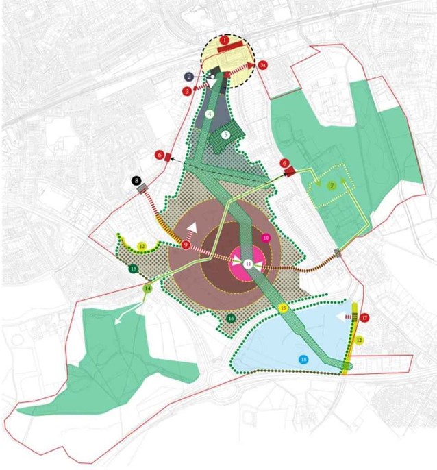
South West Maidenhead Strategic Placemaking Area: Framework Plan (see next page for key to map) (3)
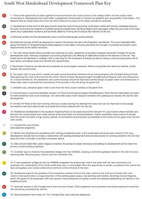
South West Maidenhead Strategic Placemaking Area: Framework Plan Key
Policy QP 1b QP1b South West Maidenhead strategic placemaking area
|
6.8.1 Ascot, one of the three main settlements in the Borough, is renowned for its royal racecourse, established in 1711. It has been identified as one of the locations to accommodate future development as part of a wider spatial strategy for the area. The Spatial Strategy (Policy SP1) states that development within the Ascot growth location will largely be focused on the High Street and its immediate vicinity, with the coordinated development of several sites related to Ascot High Street providing the opportunity to strengthen its role as a significant centre in the Borough.
6.8.2 Ascot’s District Centre (Policy TR1) provides a range of shops for the surrounding area but it is constrained by having the racecourse on one side and Green Belt on the other. The High Street has a limited mix of shops, is narrow and is dominated by traffic. There is strong support from the community(4) to see Ascot improved and enhanced, with the rejuvenation of the High Street.
6.8.3 Ascot has good transport links including railway services to London, Reading and Guildford. However, some roads suffer from congestion, including the A332 and the Heatherwood roundabout. Bus services are relatively infrequent. Pedestrian and cycle routes are poor, including from the High Street and proposed development sites to the Railway Station.
6.8.4 The built up part of Ascot is within the Metropolitan Green Belt. The Edge of Settlement Green Belt Purpose Study found that some parcels of land to the south of the High Street provide opportunities to support regeneration initiatives. Most of Ascot is within 5km of the Thames Basin Heaths Special Protection Area (SPA) where mitigation needs to be provided in the form of Suitable Alternative Natural Greenspace (SANG).
6.8.5 Ascot has a green and leafy, semi-rural character with areas of Ancient Woodland and good quality greenspace, including Allen’s Field and South Ascot Recreation Ground. However, there is more limited access to Public Parks and Gardens and amenity greenspace. The Ascot, Sunninghill and Sunningdale Neighbourhood Plan was made in 2014. This identifies existing green corridors, including a primary corridor that runs from Allen’s Field in the west through to (and beyond) the land to the south of St. George’s school and a secondary corridor running along the railway embankment from Ascot to Sunningdale.
6.8.6 Ascot has high house prices and a high proportion of older people. There is a lack of an evening economy and facilities for young people. There is a strong community aspiration for a new village square or community hub, with a relocated library and parish council offices as well as a community/arts centre and public open space.
6.8.7 The Ascot, Sunninghill and Sunningdale Neighbourhood Plan was formally 'made' by the Borough Council in 2014 and remains part of the development plan. Policy QP1c, and indeed the BLP as a whole, are not intended to supersede the policies in the Neighbourhood Plan, although where any conflicts arise in the application of the policies, the more recently adopted Local Plan will take precedence. This will be the case, for example, in relation to the uses proposed for some of the allocations within the Policy QP1c area, with the Local Plan requiring a different use on some sites, such as AL17, than was set out in the Neighbourhood Plan.
6.8.8 The BLP allocate several strategic housing sites close to the High Street, including AL16 (Ascot Centre), AL17 (Shorts) and AL20 (Heatherwood Hospital). One smaller site has also been allocated, AL18 (Ascot Railway Station car park). The Heatherwood Hospital site now has planning permission for up to 230 homes and a new hospital. Together these sites will deliver about 720 new homes. It is important to ensure that these sites come forward in an integrated and coordinated way rather than in isolation. It is also important that new residential development is exemplar quality and sympathetic to local character.
6.8.9 The Borough Council recognises the importance of ‘placemaking’ as part of planning for future growth and development, and that that the quality of the place that people live in and use will have a powerful impact on quality of life. To address the above issues, a Strategic Placemaking Policy has been developed for Ascot addressing the area shown at Figure 5. The diagram below shows the boundaries of the placemaking area, which is centred on the railway station. It includes the High Street, several proposed housing development sites, Ascot Business Park and also several green and blue infrastructure sites, including one or more new SANG sites.
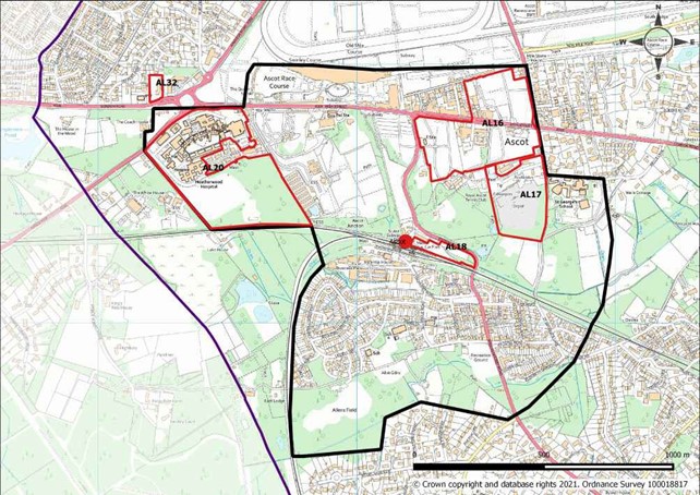
6.8.10 The boundary of the Ascot Strategic Placemaking Area includes the area to the south of the railway line (South Ascot), even though there are no allocations in this area. The Placemaking Area has Ascot Railway Station at its centre, in order to emphasise the importance of public transport. Whilst the railway station is a significant asset, the railway line acts as a barrier between the parts of the Area to the north, including the High Street (and the Racecourse) and the Area to the South, which contains existing residential development, networks of green infrastructure, such as Allen's Field and the South Ascot Recreation Ground, as well as employment uses at the Ascot Business Park. The inclusion of South Ascot will ensure that any unallocated (windfall) development sites that come forward contribute towards the wider vision for the Placemaking Area, including improving connectivity between the High Street and South Ascot.
6.8.11 The policy below seeks to rejuvenate Ascot to create a vibrant place with an improved High Street and high quality new development that is integrated into Ascot and retains its green and leafy character. It also seeks to improve connectivity so that those residents living in South Ascot are better connected to the High Street. The policy contains a set of placemaking principles that all new development will have to adhere to.
6.8.12 The Council, in partnership with the local community and other stakeholders, will prepare an Ascot Strategic Placemaking Area Supplementary Planning Document (SPD) that will expand on the policy and provide a more detailed framework to guide new development. The SPD will draw on both the aims and vision underpinning the Neighbourhood Plan and the Development Briefs it requires, including the emphasis on protecting the green and leafy appearance of the Ascot area, as well as on Policy QP1c and the placemaking work produced to support this policy.
Policy QP 1c Ascot strategic placemaking area
|
6.10.1 Green infrastructure has been defined as “a strategically planned network of high quality natural and semi-natural areas with other environmental features, which is designed and managed to deliver a wide range of ecosystems services and protect biodiversity in both rural and urban settings” (European Commission, 2013).
6.10.2 Green Infrastructure networks are highly valued by local people and form an important part of the Borough’s character and local identity. Delivery of high quality green (and blue) infrastructure has an important role in the placemaking agenda set in the Borough Local Plan as well as having benefits for climate change adaptation and mitigation and biodiversity. The following can form part of green infrastructure networks:
6.10.3 The benefits of green and blue infrastructure are fully realised when delivered at a strategic scale. In areas subject to strong intensification (for example, the Maidenhead Town Centre and South West Maidenhead strategic placemaking areas) the need for a comprehensive, high quality network of green and blue infrastructure will be especially important. The use of water, green roofs and walls, pocket parks and street-level greening is likely to be essential in providing innovative, high quality green and blue infrastructure network to support high intensity developments. The Green and Blue Infrastructure Study (2019) presents a baseline of the green and blue infrastructure assets in the Borough, drawing from national, regional and local data. It sets out key challenges and opportunities within the Borough for green and blue infrastructure and also makes recommendations around delivery. However, it is important to ensure that where possible, all future development includes an appropriate level of high quality green and blue assets. More details on how this evidence can be drawn upon to deliver biodiversity enhancements in development proposals are given in Chapter 12, for example Section 12.4 and Policy NR2. In order to provide further guidance on this important issue, the Council will prepare a Green and Blue Infrastructure Supplementary Planning Document (SPD).
6.10.4 The waterways and water bodies in Windsor and Maidenhead are distinctive components of the environment and character of the Borough. The Council will seek to ensure this blue infrastructure is maintained and enhanced wherever possible. Development will be expected to contribute to this through either the provision of additional blue infrastructure or enhancement or extension of existing water bodies where appropriate. The Maidenhead Waterways Project is recognised as an important element of blue infrastructure in the Borough that provides public open space, recreation and amenity benefits.
Policy QP 2 Green and Blue Infrastructure
|
6.12.1 One of the core planning principles of the NPPF is to always seek to secure high quality development and a good standard of amenity for all existing and future occupants of land and buildings. Design is not just about how a development looks, but is also about how well it works and meets the needs of users. It plays an essential role in the functioning of places. Well-designed buildings, places and spaces help to create attractive environments that set a positive context for the development of successful places and sustainable healthy communities.
6.12.2 All development, redevelopment and conversion should demonstrate design excellence and respond positively to its context. Development in the Borough should create safe, secure and pleasant environments both inside and outside of buildings, with careful consideration to the way people use spaces and places. These factors will not only improve quality of life, but will also attract business and visitors to the Borough.
6.12.3 The Council is committed to achieving high quality design that responds to the distinctive character of the Borough. Delivering good design is a key element of this plan. There are many different principles that go into delivering good design including visual factors, functionality, sustainability and local distinctiveness.
6.12.4 Individual places within the Borough have their own distinctive characters which have evolved over time. They are valued by local communities as part of the heritage of the area. The Council has carried out a detailed review of the character of its rural and urban areas in the form of a Townscape Assessment (2010) and a Landscape Character Assessment (2004). Both documents provide a starting point for considering local character attributes. These documents (and any updating successors) will be one of the factors taken into account when the Council is assessing the design quality of development proposals. The Council has adopted a Borough Wide Design Guide Supplementary Planning Document (SPD) to illustrate in detail what it considers to be high quality design for the Borough as a whole.
6.12.5 The NPPF encourages the empowering of local people to shape their surroundings through local and neighbourhood planning processes. The local importance of design and the need to respond to an area is something that is very important to residents as demonstrated in the Cookham Village Design Statement, the Ascot Sunninghill and Sunningdale Neighbourhood Plan and emerging neighbourhood plans. Neighbourhoods may wish to set detailed or specific design guidance for their local areas through Neighbourhood Plans or Village Design Statements. The Borough will view favourably those proposals that have actively sought, and incorporated the views of the local community throughout their design.
6.12.6 The Council recognises that in some locations the scale of development will be such that it will create its own identity and character. In such locations, innovative and creative solutions may need to be applied to provide acceptable sustainable design solutions in terms of character, amenity, and supporting infrastructure. Such locations will include Maidenhead Town Centre (as defined on the Policies Map) and the cluster of sites to the south of Maidenhead Town Centre based around Maidenhead Golf Course. Opportunities exist to use more dynamic variations in building heights, although exemplar design will be expected.
Policy QP 3 Character and design of new development 1. New development will be expected to contribute towards achieving sustainable high quality design in the Borough. A development proposal will be considered high quality design and acceptable where it achieves the following design principles:
|
6.14.1 Policy QP3a addresses the height of all new development, with specific urban design criteria for tall buildings. The purpose of the policy is to respond to increasing pressure for higher density and taller development in the Royal Borough. This will ensure that the unique character of the Royal Borough’s towns and villages is protected from inappropriately tall development by directing taller buildings to areas where they can play a positive role in placemaking, and by providing a criteria based approach to establishing the appropriateness of tall buildings. The largely low-rise, rural context and landscape setting of towns and villages are important characteristics of the Royal Borough, which should be preserved and enhanced.
Definition of Tall Buildings and their height
6.14.2 A tall building is an exceptional development that is significantly higher than the buildings in its surrounding context and that notably breaks the skyline. As such, ‘tall building’ is a relative term. A building is considered tall in relation to the height of its surroundings, which is called the ‘context height’. The context height is the height that an observer would read as the typical or defining height of a particular area.
6.14.3 The relationship of height between a tall building and its context can be expressed as a factor of the prevailing context height. This is the context height ratio (CHR), which expresses the degree of height of a building in relation to its context. This provides a measure of the extent to which a building is ‘outstanding’ on the skyline considering the prevailing height and scale of the existing place.
6.14.4 Tall buildings with a height of 1.5 to 2.5 times the context height will be prominent and outstanding features in an area. Thus any building exceeding 1.5 times the context height of the surrounding area (or a minimum of 4 storeys in a 2 storey area) will be defined as a tall building for the purpose of Policy QP3a. Whilst their height is exceptional, they retain a proportionate relationship with their context and commonly are perceived as integral parts of a local townscape. Buildings with heights above 2.5 times the context height rise up into the sky and have a more detached relationship with the lower rise context. Such a relationship is only justifiable in places with highly urban and central characteristics where this increased height forms part of the place character, supports intensification and visually marks a place of district-wide importance on the skyline. The only place in the Royal Borough where a building of such increased height may be acceptable is within the town centre of Maidenhead. In the remainder of the Royal Borough, heights of above 2.5 times the context height will not generally be appropriate.
Impact of Tall Buildings
6.14.5 Due to their greater height and visibility tall buildings can have a greater impact on their immediate and wider environments, both positive and negative. As such proposals for tall buildings require higher levels of scrutiny than development of lesser height.
6.14.6 Tall buildings such as Windsor Castle and the spires of churches have been a part of the Royal Borough for centuries. Their enhanced visibility contributes to distinctive skylines and enhances legibility by landmarking important locations such as town and village centres. When carefully located and designed, new tall buildings can serve those same functions and be welcome additions to the Royal Borough’s settlements. They can also catalyse regeneration and make effective use of constrained sites in central locations.
6.14.7 Inappropriately located, designed or scaled tall buildings can cause significant adverse impacts on their immediate and wider contexts by appearing overly prominent in views, causing harm to heritage assets and their settings, drawing attention away from historic landmarks or skyline features, resulting in overshadowing and overlooking of low-rise housing and gardens, or by being out of place and detracting from the character of towns and villages.
Tall Building Locations and Design
6.14.8 Generally a tall building proposal should form part of the comprehensive development of a large site where it can contribute to the regeneration and enhancement of a wider urban area. Tall buildings should only be considered where they are part of a plan-led and collaborative strategy for change. As part of this approach, tall buildings must complement existing townscape characteristics or positively contribute to placemaking and enhance the legibility of areas.
6.14.9 Proposals for tall buildings will need to carefully consider and test their potential impact on sensitive heritage, landscape and townscape assets in their immediate and wider surroundings.
6.14.10 Due to their visual prominence, tall buildings will need to integrate positively with their context and contribute to a sense of place and local pride. Policy QP3a provides key location and design principles that will ensure that tall buildings are only brought forward in the right places, with an appropriate height and can achieve the highest architectural and urban design quality.
6.14.11 The Royal Borough will prepare a Building Height and Tall Buildings SPD. This will identify locations that present opportunities for tall buildings in the Royal Borough, together with site-specific recommendations on building height. It will provide additional detailed guidance on location, height and design of tall buildings and set application requirements for tall buildings.
Policy QP 3a Building Height and Tall Buildings General approach to heights in the Borough
Tall Building Definition
Tall Buildings Urban Design Principles
|
6.16.1 The River Thames is one of the Borough’s most important natural and cultural assets, providing extensive leisure, ecological, environmental, landscape and economic benefits. It is essential to ensure that this importance and attraction is preserved whilst welcoming the opportunities the river brings for positive change.
6.16.2 The NPPF states that ‘the planning system should contribute to and enhance the natural and local environment by protecting and enhancing valued landscapes’. High quality development proposals within the River Thames Corridor can make a positive contribution to the character and setting of this important landscape.
6.16.3 Policy should support and promote the key heritage attractions associated with the River Thames. This applies to development of all uses and scales with an impact on the River Thames and its setting, including the valley sides and crests which form a distinctive topographical feature, and the flat open floodplain where change could have a significant impact on views from the river.
6.16.4 In built-up areas the setting may, in places, be defined simply by the line of buildings closest to the river, but in other places could comprise a wider area including entire villages such as Bisham, Temple and Hurley due to their relationship to the river and the nature of the valley topography. Similarly, historic buildings and their settings that have a visual or historic link with the river, for example Windsor Castle and Eton College, would also form part of the river setting.
6.16.5 The River Thames flows through the Borough for 25 miles making a unique contribution to the environment and forming one of the Borough’s most significant landscape features. It includes stretches of great scenic character, for example steep wooded slopes between Bisham and Maidenhead, and extensive floodplain valleys such as around Hurley. It also has stretches with deep historic associations, often with national importance, such as in Windsor, Eton and Ankerwycke.
6.16.6 The quality of the building and spaces alongside the river makes an important contribution to the Borough’s environment and enjoyment of the river. Every stretch of waterway has its own character and this needs to be reflected in the design of new development.
6.16.7 The principles of high quality design are set out in 'Policy QP3 Character and Design of New Development'. Particular care will be taken to ensure developments within the setting of the Thames complement the distinctive character of the water frontage and important views. The extent of the setting of the Thames is defined on the Policies Map.
6.16.8 In addition to the scenic and cultural benefits, the River Thames Corridor provides many opportunities for sport and leisure. Some of these opportunities are active, some involving the water, and others simply benefiting from the calm and reflective feeling of being near water. Both active and passive activities can contribute towards improving the health of residents and visitors and should be protected. There is public access to much of the River Thames including the Thames Path National Trail.
6.16.9 River-related services, businesses and infrastructure, make an important functional contribution to the character and use of the River Thames. This is especially the case for those involving the construction, repair and servicing of river craft; make a vital contribution to the continuation of the historic traditions and function of the River Thames. The Council endorses the principle of supporting sites associated with river-related activities and employment. Opportunities for generating renewable energy will also be supported in principle, provided that they do not adversely impact on the River Thames Corridor.
6.16.10 The variety of wildlife related to the river, its tributaries and islands adds to the enjoyment of the river. 'Policy QP4 River Thames Corridor' seeks to maintain the ecological value of the river and in appropriate circumstances, restore and enhance natural elements of the riparian environment.
6.16.11 In 2015, the River Thames Alliance published the Thames Waterway Plan, an integrated strategy for the river to 2021. Furthermore, the Environment Agency has produced a River Basin Management Plan, Thames River Basin District in 2015, which seeks to manage the pressures facing the water environment of the river basin.
6.16.12 Policy QP4 seeks to promote the healthy growth in the use of the River Thames for communities, wildlife, leisure and business in ways that are compatible with its character, setting and ecology, and is in line with the objectives of these plans. The Borough will work with adjoining authorities and other partner organisations where needed to prepare wider strategies or projects.
Policy QP 4 River Thames Corridor
|
6.18.1 The whole of the Borough lies within the extent of the Metropolitan Green Belt which surrounds London and only a number of settlements are excluded from it. The Green Belt is used for agriculture, forestry, open land and recreational uses and also includes a number of small villages and hamlets, educational establishments and other institutional uses, employment premises and mineral workings. The Green Belt is valued not only for the open countryside it provides in the Borough, but also for its natural beauty, wildlife and historical and cultural associations.
6.18.2 The main aim of Green Belt is to prevent urban sprawl by keeping land permanently open. Green Belt also provides opportunities for people to access the countryside, to protect land for agriculture, forestry and similar land uses, and for nature conservation.
Villages and large developed sites in the Green Belt
6.18.3 The Green Belt contains a large number of villages. The larger villages(5) are inset from the Green Belt whilst the remainder(6) are washed over by the Green Belt designation. Whilst not villages, large previously developed sites such as Windsor Racecourse, Ascot Racecourse and Legoland are also washed over by the Green Belt designation.
Development in the Green Belt
6.18.4 The BLP seeks to manage development pressures so as to protect and enhance the quality and distinctive character and heritage of its settlements and the countryside that surrounds them. Development in the Green Belt will be restricted as set out in national policy. Inappropriate development is considered by definition to be harmful to the Green Belt and will not be approved by this Council, except in very special circumstances. A very special circumstances case to justify development will not exist unless the potential harm to the Green Belt by reason of inappropriateness, and any other harm, is clearly outweighed by other considerations.
6.18.5 Whilst most forms of development are considered inappropriate in the Green Belt, national planning policy lists certain exceptions which are not inappropriate. These are set out in paragraphs 89 and 90 of the NPPF.
6.18.6 Further clarification is provided below on several of the key forms of Green Belt development in the Royal Borough which are not automatically defined as being inappropriate:
Agricultural and forestry workers dwellings
6.18.7 Applications for new dwellings in the Green Belt for a worker engaged in farming or forestry will be judged on a case by case basis. Any such dwelling should be:
6.18.8 Consideration may be given to the removal of some permitted development rights for the extension of dwellings so approved to ensure that the dwelling remains proportionate and available to the agricultural holding in the long term. The Council will look to use temporary planning permissions where a new agricultural or forestry enterprise is being established and viability is not yet proven.
Limited infilling
6.18.9 Development within villages in the Green Belt is limited to small scale infilling. For the purposes of this policy, limited infilling is considered to be the development of a small gap in an otherwise continuous frontage, or the small scale redevelopment of existing properties within such a frontage. It also includes infilling of small gaps within built development. It should be appropriate to the scale of the locality and not have an adverse impact on the character of the locality.
6.18.10 Case law has now established that the infilling in villages exception is not restricted to sites that fall within identified settlement boundaries in local plans. This impacts on villages with defined boundaries shown on the Policies Map and small villages that do not have defined boundaries.
6.18.11 Where the built form of a village extends wider than the settlement boundary the Council will need to assess whether or not the proposal site could be understood as falling within the wider understanding of the village extent and thus able to benefit from the limited infilling exception. Proposal sites for villages where no boundary has been defined will need to be assessed on a case by case basis. The Council considers there to be very few opportunities for limited infilling in those smaller villages where no settlement boundary has been defined. Should any proposals come forward, these will be considered on their planning merits, taking into account national and local planning policies (including any policies in made Neighbourhood Plans).
Facilities for outdoor sport, outdoor recreation and cemeteries
6.18.12 There are many existing sport and recreation facilities in the Borough's Green Belt, including football pitches, golf courses, and cricket grounds. The Green Belt in the Borough also contains a number of cemeteries and for their continued proper functioning, the need for new associated buildings occasionally arises.
6.18.13 As the principal objective of Green Belt policy is to maintain an open character it follows that any new building, as well as the treatment of associated outside space, including for access and car parking, should be no more than is genuinely required to enable that use to be carried on. Even then, the consequent impact on the Green Belt may render a proposal unacceptable and in accordance with core planning principles it will be preferable if an existing building can be converted to provide the accommodation required.
6.18.14 Any development, including any new access, car parking areas, floodlighting or additional curtilage, should be unobtrusive and will not be acceptable where it would create a significant and essentially urban element in the landscape to the detriment of its Green Belt setting. Consideration will be given as to whether the new facility proposed would lead to the expansion of the existing use to the extent that it would become unacceptable in its location because the noise and other disturbance it would generate, both on site and on the road network leading to the site, would be harmful to the amenity of local residents or people visiting the area for recreation. In these cases permission should not be forthcoming.
Equestrian facilities
6.18.15 As a consequence of changes to agricultural practices and a decline in agriculture generally, the fragmentation of former agricultural holdings often results in individual land parcels being used for the keeping and grazing of horses, where a need for new stabling, including associated buildings for the storage of feed and tack, can arise. Usually the proposal will be for ready-made stables and these are generally acceptable where they are of timber construction and can be appropriately and unobtrusively sited.
6.18.16 The use of more permanent materials should be resisted as this can result in a proliferation of permanent structures to the detriment of the open character of the landscape should the use as a stable cease. Stables should where possible be sited where access already exists, as the impact of any new access will be taken into account in assessing impact. In all cases the local authority will ensure that regard has been made of latest guidelines on the welfare of horses to ensure that the scale of the proposal is proportionate to the amount of land associated with it and proposals deemed excessive will not be acceptable.
6.18.17 Facilities for the exercising of horses, (usually referred to as a manege), riding arenas, training facilities and horse walkers may be acceptable in the Green Belt as they are associated with an open land use, provided that they can be unobtrusively located and designed and do not detrimentally impact on residential amenity, highway safety and landscape quality. They are structures that require a large, flat surface and in many cases this cannot be achieved without a significant degree of engineering involving the realignment of slopes and erection of retaining structures. This can have a significant impact on the character and appearance of the local landscape and any proposal that would result in a detrimental impact will not be acceptable. Where the degree of engineering and impact can be accepted, it will be expected to be mitigated through the use of appropriate hard and soft landscaping. This will include consideration of the type of surfacing and boundary treatment proposed which should be appropriate to the character of the surrounding landscape.
6.18.18 Floodlighting for a manege will not be accepted as this is deemed to have an undesirable urbanising effect and can lead to unacceptable light pollution in the countryside.
6.18.19 Encouragement will be given to off road riding facilities such as headlands or bridleways within farm units.
Conditions
6.18.20 The Borough will impose such conditions as may be appropriate to ensure that the openness of the Green Belt and the purposes of including land within it are maintained and identification of the extent of any residential curtilage. This may include withdrawal of permitted development rights, limiting use and/or duration, creating personal permissions and using occupancy conditions.
Amendment of Green Belt boundaries
6.18.21 National planning policy requires that Green Belt boundaries are only amended in exceptional circumstances and that this must be undertaken as part of the Local Plan process. We consider that exceptional circumstances exist to justify a small amendment of Green Belt boundaries in order to facilitate the growth that is needed in the Borough and promote sustainable patterns of development. Whilst the general extent of the Green Belt has been retained, a very small amount of land will be removed during the plan period in order to enable development around the Maidenhead urban area, and the edges of selected villages. The amount of Green Belt in the Royal Borough remains well over 81%. Details of the specific areas released from the Green Belt, and their resulting new designations, are set out in Appendix A.
6.18.22 Paragraph 85 of the NPPF sets out a series of points for local planning authorities when defining Green Belt boundaries. To ensure Green Belt boundaries are readily recognisable and use permanent durable boundaries in some cases areas not included in the site boundary have been realised from the Green Belt. These areas will form part of the relevant settlement, and development proposals determined through the application process.
6.18.23 The general extent of the Green Belt to remain during the Plan period is shown on the Policies Map. The Green Belt will be maintained and supported through the BLP strategic and non strategic policies.
6.18.24 There are opportunities for local communities to develop detailed site development briefs for those areas removed from the Green Belt through Neighbourhood Plans. This can further support sustainable, high quality design and placemaking, by ensuring new development positively contributes to local places and which accurately reflect the aspirations of the local community.
Policy QP 5 Policy QP5 Development in Rural Areas and the Green Belt General
Green Belt
Rural Uses
Equestrian Development
Facilities for Outdoor Sport, Outdoor Recreation or Cemeteries
|
1 (over 10 residential units or 1,000 sq. m of floorspace or 1 ha in area)
2 Figure 2 derives from the MTC Placemaking Study 2019 and is indicative only. The red line indicates the Boundary of Maidenhead Town Centre.
3 Figures 3 and 4 are a schematic map and key produced for the South West Maidenhead Placemaking Study (October 2019) and are indicative only. Whilst the principles shown provide the broad framework for the SPD masterplanning process, the detail may be subject to change, as a result of further technical work, stakeholder engagement, and discussions with the relevant landowners and developers about the South West Maidenhead SPD. It should also be noted that figure 3 does not show the full extent of the AL13 allocation.
4 Sunninghill, Sunningdale and Ascot Neighbourhood Plan 2011-2026, para. 5.3.1
5 Broomhall, Cookham, Cookham Rise, Datchet, Eton, Eton Wick, Old Windsor, Sunningdale, Wraysbury
6 Bisham, Bray, Burchetts Green, Cheapside, Fifield, Holyport, Horton, Hurley, Hythe End, Knowl Hill, Littlewick Green, Shurlock Row, Warren Row, Waltham St Lawrence, White Waltham, Woodside
7 The settlement boundaries for those villages listed at footnote 5 and footnote 6 of this Local Plan.
< Previous | ^ Top | Next >