
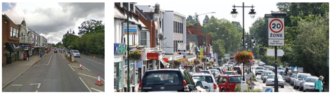
The key issues currently affecting Ascot are:
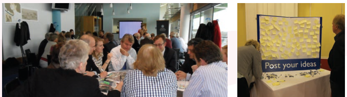
The vision for how Ascot Centre can be rejuvenated was developed with the help of The Prince’s Foundation using their “Enquiry by Design”. This involved them working closely with the NP team and the community to address all these issues and to determine how best to ensure a more thriving daytime and evening economy for the area. Their full report is submitted as part of our Evidence Base.
It should also be noted that, in addition to widescale and repeated community consultation, the NP team has also consulted widely with landowners and other stakeholders connected with Ascot, with RBWM, and has conducted interviews with many of the local retailers and business owners.
To create a mixed and sustainable residential and retail centre in the heart of Ascot that reflects the world-renowned standing of its Racecourse and delivers a community hub, a vibrant and prosperous daytime and evening economy, and a safe, attractive, thriving High Street for residents and visitors.
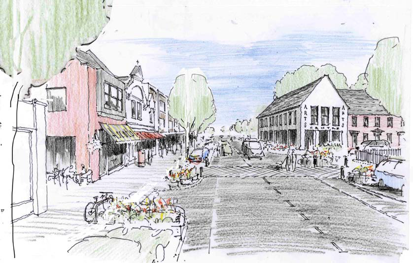
To deliver a community centre and public open space at the heart of Ascot to act as a gathering point and hub for local residents. The community centre should be capable of acting as a community hall and a small cinema and/or arts space, along the lines of The Firestation in Windsor (www.firestationartscentre.com). The public open space is envisaged as a landscaped square or piazza, with seating and space for the community to gather.
To retain mature trees which are a particular feature of the area.
To retain or create open green spaces throughout the area, and to reflect the green openness that characterises the area.
To achieve necessary and much desired improvements to the traffic infrastructure in and around Ascot High Street.
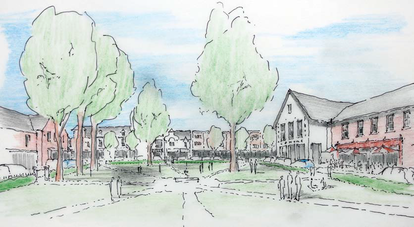
To focus new housing around the centre of Ascot, where residents will have easy access to the railway station, and where they can both benefit from and help sustain the local economy of shops and food outlets.
To ensure that housing is built in a way that is sympathetic to the green and leafy character of the area and contributes to the overall mix of housing types that the local community have said they want.
To the north of the High Street, the “Ascot Village” concept is intended as a modest style residential development, similar in character and scale to the two story terraced houses on Course Road.
To deliver additional retail and complementary leisure uses such as pubs, restaurants and cafes to encourage a vibrant and varied High Street for local residents and visitors.
To provide better parking to meet the needs of businesses, shoppers, residents and visitors. Parking should be made available for the community during race days.
To provide safe and accessible pedestrian and cycle routes in and around Ascot centre and from the centre to the station, to North Ascot, Heatherwood and South Ascot.
To support the development of a hotel at Ascot Racecourse to support multi-day conferences which reduce the need for travel to and from the racecourse on a daily basis, and to provide leisure facilities and employment for the local community.
To encourage delivery of small starter business units to encourage greater economic activity in Ascot.
To achieve this vision, it is important that a holistic approach to development of Ascot Centre is taken, promoting close collaboration between landowners, developers and other key stakeholders including the community. A Development Brief (see Appendix C) is required to ensure meaningful engagement and consultation takes place with the community on development plans for Ascot.
To ensure that development is phased so that infrastructure improvements and community facilities are delivered ahead of or in parallel with it and so that it does not impact adversely on the economic activity of the High Street.
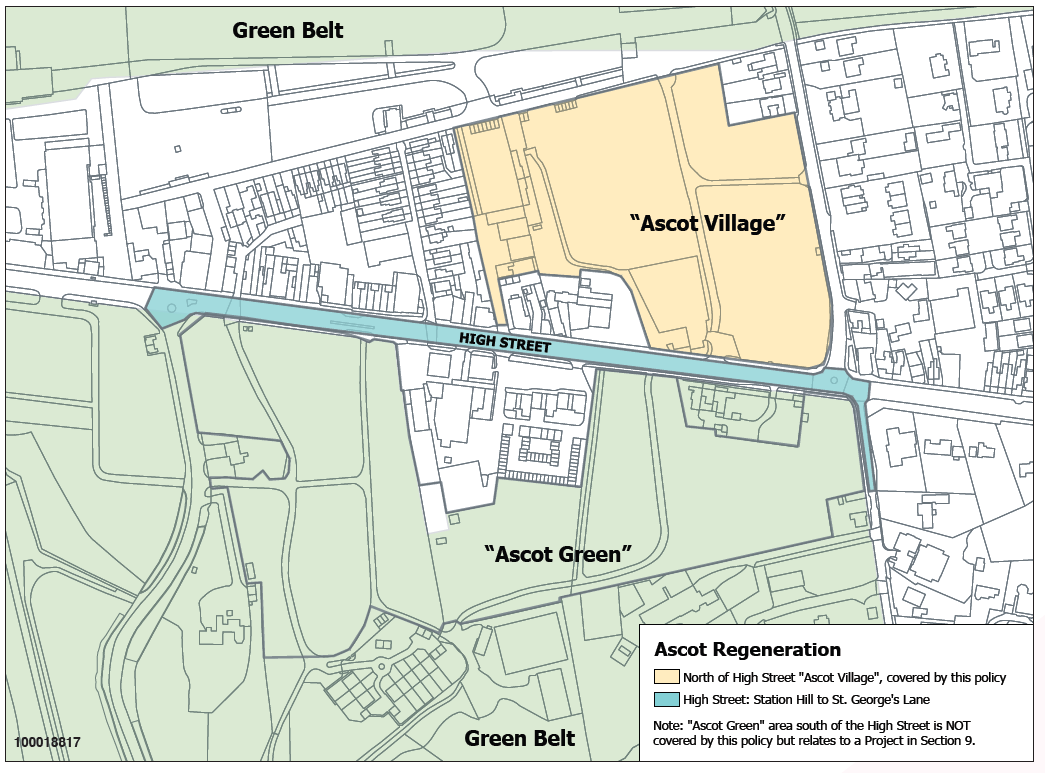
NP/SS1.1 A Development Brief as set out in Appendix C, encompassing all of Ascot High Street and Centre (including “Ascot Village”) as identified on Map 15 will be required in advance of any application for development. Any relevant development proposals must be in line with this Development Brief and must be accompanied by a Statement of Community Consultation, as set out in Appendix D.
NP/SS1.2 Any proposal for the redevelopment of Ascot Centre and High Street should take into account the following community aspirations:
NP/SS1.3 These requirements will be delivered by new housing and commercial/mixed development as follows:
NP/SS1.4 High quality of design is a key consideration for this development. The design of any development at Ascot Centre will need to make the most of existing features, in particular the mature trees, and will need to deliver a centre which demonstrates local characteristics, creating a pleasant environment for residents, workers and visitors, whilst reflecting the global importance of the racecourse.
NP/SS1.5 PHASING: Development at Ascot Centre must be phased to ensure there is no adverse impact on the economic activity of the High Street and to ensure that any cumulative impacts of development can be dealt with. The Development Brief must include proposals for the phasing of both the development and of all the required improvements and amenities, with clear milestones and deliverables. The phasing proposals must demonstrate how the infrastructure improvements and amenities will be delivered in phases alongside the phased delivery of the development in advance of each phase being occupied.
The local community is supportive of a hotel in Ascot but historically there has been concern about some of the proposed locations. During The Prince’s Foundation Enquiry by Design, a location was identified on Ascot racecourse land adjacent to the Grandstand (see Map 16), and this received support.
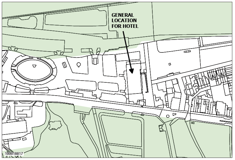
Development proposals for a hotel with conference facilities on the location shown on Ascot Racecourse on Map 16 shall be permitted subject to:
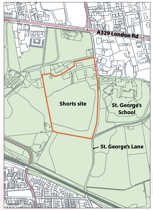
This is a site of c. 5.6 hectares of mainly previously developed land (PDL) in Green Belt, located between Ascot and South Ascot. As a recycling transfer station, the site processes waste collected, whether demolition materials, the contents of skips or refuse.
The requirements of the business mean that skip lorries and other HGVs make frequent trips to and from the site throughout the day. St. George’s Lane is narrow, has a number of residential properties and leads to a school. Its access onto the main London Road is awkward, being offset from the Winkfield Road roundabout. Many of these lorries then route through the narrow and busy Ascot High Street, which is far from ideal.
We understand the site owners are potentially interested in considering relocation to another site outside our NP area and there would be considerable public support for this to happen. We would like to see the site redeveloped with improvements to the landscape and environment. Access however would need to be improved.
To encourage redevelopment of the present Shorts site for alternative uses.
To deliver environmental improvements to the Green Belt and protect it from inappropriate development.
To ensure that any redevelopment includes improvements to St. George’s Lane and the access to the Winkfield Road roundabout.
NP/SS3.1 This is a site in Green Belt and redevelopment of it should only be considered in accordance with relevant Green Belt policies.
NP/SS3.2 Proposals for the appropriate re-use of the site should demonstrate:
Heatherwood Hospital is one of the larger sites providing employment in our NP area. It is part of the Heatherwood & Wexham Park Hospitals NHS Foundation Trust (“HT”) and there have been various engagements and consultations over the last couple of years by Berkshire East PCT and the HT about its future.
The site comprises:
There is a very strong public desire to retain a hospital on this site, but the degree to which this can be delivered is outside the scope of this Neighbourhood Plan.
At the time of writing, we understand that the stated intention of the HT is to build a modern, purpose-built hospital to house the services that will be retained on-site. This will require a much smaller footprint than that currently occupied by the hospital buildings. This would enable the HT to sell off the rest of the land for development, which would help finance the new hospital.
The likelihood of part of the Heatherwood site being developed for housing was made clear to the community in our Options consultation, and we consulted on the type of housing development that residents would prefer to see take place.
Other factors about this site that are important to the community include:
As at the time of writing, discussions are taking place between the Boards of Heatherwood & Wexham Park Hospitals NHS Foundation Trust and Frimley Park Hospital NHS Foundation Trust regarding the possibility of the latter potentially acquiring the former. It seems unlikely that this will have a significant impact with regard to the future of medical services or development at the Heatherwood site.
To ensure that the non-developed part of the Heatherwood site remains subject to the Borough’s and national Green Belt policies.
To secure as far as possible the continued existence of a hospital or healthcare services on the site, albeit we have no direct influence on what services are provided there.
For previously developed land that is not required for a new hospital, the site may support its change of use to become residential, thereby delivering an important contribution towards our housing needs. Any such proposals must take account of the community’s concerns, wishes, and needs, as reflected in feedback from our Options consultation. The community expressed a preference for a mix of housing types, including, in order of priority, small or terraced houses, retirement homes, modest family homes, live/work units that combine living and professional workspace in the same building, flats for single-person households, and 4+ bedroom larger executive houses.
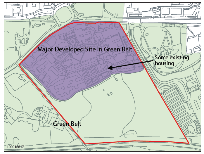
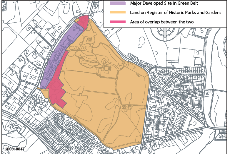
For purposes of clarity, the area shown on Map 18 as Green Belt, which is not part of the Major Developed Site (MDS), remains subject to Green Belt policies.
NP/SS4.1 Notwithstanding our policy NP/E1, redevelopment proposals for the Major Developed Site area of the overall Heatherwood site, as shown on Map 18, for residential use shall be permitted provided only that part of the site remains in its current use as a hospital or a provider of healthcare services.
NP/SS4.2 In accordance with our policy NP/H1, a Development Brief must be produced prior to any planning application. This must encompass the entire Major Developed Site area being proposed for development, as defined on Map 18.
NP/SS4.3 Development proposals on this site are required to demonstrate high quality design reflecting the site’s location as a gateway to Ascot.
NP/SS4.4 Development proposals for the Heatherwood site are required to demonstrate the following:
There is a strong desire to ensure the future viability, vitality, and prosperity of Sunningdale’s retail centre. This is currently split in two by the A30, the railway line, and the difficult, busy junction of the A30 with Chobham Road.
An important consideration for any significant development here is DERA, a major redevelopment site in Surrey, just across our border. The proposals include c. 79,000 square metres of employment development and up to 2,500 additional housing units.
There is concern that DERA could have a significant impact on traffic congestion and parking in Sunningdale, especially around the retail centre along Chobham Road and its junction with the A30, aggravated by the nearby level crossing, and potentially with knock-on effects extending onto other roads in our NP area.
It is uncertain whether DERA’s impact on Sunningdale’s retail economy will be positive (increased footfall), negative (traffic congestion putting existing customers off visiting), or a combination.
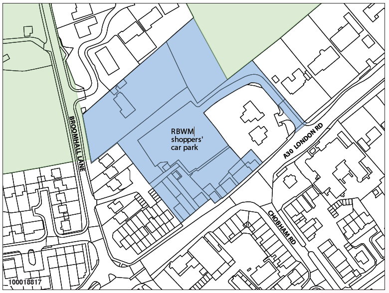
Sunningdale Broomhall Centre (referred to in consultations as “Sunningdale RBWM car park area”) is an area to the north of London Rd, opposite Chobham Rd. It currently consists of residential property and retail and commercial enterprises, surrounding a surface level RBWM-owned free car park, and bordering open fields looking over towards Old Sunningdale. Pedestrian access to the area is from footways set between the retail businesses on the A30 London Rd and between houses on Broomhall Lane. Vehicle access is from the busy A30 London Rd.
Sunningdale is officially classified as a “district centre”. Based on the 2011 Census there are 2,135 households in Sunningdale, which probably explains why the local community think of it and refer to it as a “village”.
In feedback from our Options consultation, the community were supportive of a mixed redevelopment in the area of Sunningdale Broomhall Centre, to include smaller retail units, additional parking, and residential; there was also support for the development to include a medical centre.
Increasing the number of smaller independent retailers would promote a more varied and competitive retail offering, which would benefit the local economy and residents. There was, however, strong opposition from the local community (62% against and 73% among Sunningdale residents) to any redevelopment which included a large “anchor” store such as a supermarket.
Being so close to Sunningdale Station and part of a mixed development makes this a site where flatted development is considered appropriate and sustainable.
There is a desire to see pedestrian walkways improved, especially a walkway to link the two parts of the retail centre.
To deliver a new mixed development that demonstrates design excellence that is in keeping with the character of Sunningdale.
To ensure the development includes a balanced mix of both retail and residential together with the desired infrastructure improvements and community amenities.
To deliver a retail offering in the centre of Sunningdale that enhances and complements the existing retail offering and to specifically preclude a new large ‘anchor’ store.
To provide additional car parking for shoppers, workers, and visitors.
To make it easier for pedestrians to cross from the shopping area on one side of the A30 to the other and to Chobham Road.
To achieve an appropriate and holistic redevelopment of this area by promoting close collaboration between landowners, developers, and other key stakeholders including the community. A Development Brief (see Appendix C) is required to ensure meaningful engagement and consultation takes place with the community on development plans for this site.
NP/SS5.1 A Development Brief as set out in Appendix C, encompassing all of Sunningdale Broomhall Centre as defined on Map 19, will be required in advance of any application for development. Any relevant development proposals must be in line with this Development Brief and must be accompanied by a Statement of Community Consultation, as set out in Appendix D.
NP/SS5.2 Any development proposals for Sunningdale Broomhall Centre must deliver the following improvements and community amenities:
NP/SS5.3 These requirements will be delivered by new mixed development as follows:
NP/SS5.4 Any development proposal on this site must deliver design excellence which reflects the local character and quality of the area and enhances the way it functions.
NP/SS5.5 PHASING: The Development Brief must include proposals for the phasing of both the development and of all the required improvements and amenities, with clear milestones and deliverables. The phasing proposals must demonstrate how the infrastructure improvements and amenities will be delivered in phases alongside the phased delivery of the development.
There was community support in the Options consultation for double-decking the car park at Sunningdale Station, but more concern about double-decking the Waitrose car park on the basis that it was likely to exacerbate traffic congestion on that stretch of the A30 and the junction with Chobham Road.
The option of some flatted development at Sunningdale Station car park was very negatively received, with only 18% supporting. This was reinforced in RBWM’s Local Plan Sites consultation, in which 65% of respondents objected to development of the site for new homes generally.
A small-scale expansion of retail development around Sunningdale Station would respond to the community’s desire for greater retail variety and contribute to the goal of helping link the existing shops along Station Parade with the shops on the other side of the level crossing.
To increase parking capacity in Sunningdale for commuters, shoppers, workers, and visitors.
To encourage a small amount of retail development around Sunningdale Station.
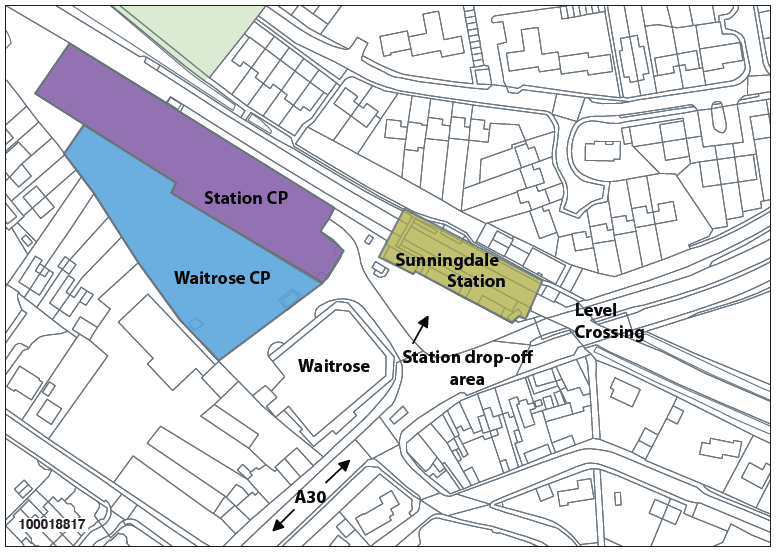
NP/SS6.1 Development proposals to expand parking capacity at Sunningdale Station by adding a second deck to the present car park, as shown on Map 20, will be permitted, subject to considerations of traffic impact and design. For purposes of clarity, proposals which also include residential development shall be refused.
NP/SS6.2 Development proposals to expand or redevelop the retail offering by Sunningdale Station and its drop-off area in the form of a small number of modest-sized units, typically around 50 square metres appropriate for serving the needs of commuters, will be supported.
NP/SS6.3 Development proposals to expand parking capacity at Waitrose by adding a second deck to the present car park, as shown on Map 20, may be permitted subject to considerations of design AND provided an independent traffic impact assessment shows that any resulting increase in traffic movements onto and off the A30 will not impact adversely on traffic congestion in the area. For purposes of clarity, proposals which also include residential development shall be refused.
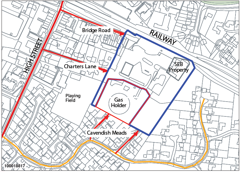
The Gasholder site and gas works is at the end of Bridge Road and just south of the railway line cutting in central Sunninghill. The site is located behind housing and light industrial units on Bagshot Road and abuts the playing field behind the Chandler Day Centre and Cavendish Meads housing estate. The site is approximately 2.4 hectares, excluding an electrical sub-station which is to be retained. This area is classified as Industrial and Commercial in the RBWM Townscape Assessment, so is a brownfield site. It is fairly flat and sits at a lower elevation than Bagshot Road. The site requires some work to prepare it for development: the gasholder has to be decommissioned and there is some contaminated land to be dealt with.
At the time of writing, the owners, National Grid, have applied for planning permission to clean up the site and have confirmed they wish to redevelop the site for housing.
The site is not convenient for a station, and bus services are very limited. National Grid’s stated preferred vehicle access to the site is via Bridge Road (which they own), which has access and egress directly onto the High Street. There is also potential access via the narrow Charters Lane and two cul-de-sacs in Cavendish Meads, which invoke ransom strips.
The overall Plan strategy is to locate new development where it is most sustainable, but also to favour development on brownfield sites. Consultations have indicated overall support for the Gasholder to be redeveloped, but community feedback also wants any development to recognise other key factors, such as:
There are two small wooded areas on the site and, in line with our Trees policy NP/EN3, we would expect these trees to be substantially retained. It may be possible for the larger of the two areas, which is 0.309 ha, to form part of the public green space we are seeking for community use.
During the consultation process with the community, the idea was put forward of moving St. Michael’s Primary School to the Gasholder site. This would allow room for the school to expand (more primary school places will be required in the area) and have the added benefit of the school having its playing fields adjacent to it – currently children have to walk along the highly trafficked High Street and then cross it to get from the school to the playing fields. St. Michael’s have expressed interest in principle in the idea and we would like to encourage it as an option for this site.
To actively support the redevelopment of the Gasholder site.
To minimise the impact on Sunninghill High Street from the likely increases in traffic movements.
To ensure that site accesses are safe, viable, and do not adversely impact on the amenity of residents and businesses along them.
To ensure a mix of dwellings, appropriate for the area, with a strong preference for houses over flats.
To avoid exacerbating the congestion and existing shortage of parking in Sunninghill.
To deliver a publicly accessible open green space for the community.
To improve cycle and pedestrian routes in the area.
To support the possibility of moving St. Michael’s School to a new building on this site.
NP/SS7.1 Any development proposals for the Gasholder site must encompass the entire area defined on Map 21. In accordance with our policy NP/H1, a Development Brief is required. Any relevant development proposals must be in line with this Development Brief and must be accompanied by a Statement of Community Consultation, as set out in Appendix D.
NP/SS7.2 Development proposals for the Gasholder site must take the following requirements into account:
NP/SS7.3 Whilst not a policy requirement, any proposals to develop a new school on the site next to the adjacent playing fields will be supported.
Sunningdale Park is a large site of approximately 32 hectares (79 acres), situated in the Green Belt. Owned by the Government, it was previously occupied by the National School of Government but is currently on a long lease to De Vere Venues, who run it as a private sector hotel and conference centre.
The overall site includes:
The site is 2.4 km from the nearest railway station at Sunningdale and a 16-minute walk from a local village centre, which makes it less sustainable than most of our strategic sites for residential development.
This is an important site providing jobs in our plan area, and we would very much like to see it retained in this capacity, fully accepting the need for flexibility in the type of alternative employment uses for the site. We also recognise, however, that it may ultimately come to pass that the only viable option for securing the site’s future is for a change of use for residential.
We recognise Northcote House is potentially at risk as being no longer fit for purpose in its current use. In line with the NPPF’s para 17 on encouraging the reuse of existing resources, including conversion of existing buildings, we recognise that alternative options for securing the future of Northcote House may need to be considered.
The area of land not part of the Major Developed Site is Green Belt that is not previously developed. As such, it and any buildings on it are subject to Green Belt policy.
As noted above, these gardens and parkland are of special historic interest and of national importance.
To ensure the community is involved in drawing up plans for any redevelopment of this important site.
To encourage the continued provision of jobs on the site, for the benefit of our economy, if at all possible.
To ensure that redevelopment delivers appropriate mitigation for any increase in traffic, improvements to pedestrian and cyclist routes, as well as access for the general public, across the parkland.
To ensure that any redevelopment is sympathetic to the character of the area.
To secure benefits for the community from any redevelopment.
NP/SS8.1 In accordance with our policy NP/H1, a Development Brief is required. Any relevant development proposals must be in line with this Development Brief and must be accompanied by a Statement of Community Consultation, as set out in Appendix D.
NP/SS8.2 Redevelopment of the site for uses providing jobs is strongly favoured, to include high-technology industries, education, training, research, hospitality, leisure or other service uses or spaces for occupation by micro or small businesses. Proposals resulting in the loss of jobs will only be considered if it can be demonstrated through a detailed viability assessment that the provision of uses creating employment are not viable or appropriate and provided that the proposal will deliver considerable benefit for the local community.
NP/SS8.3 Any redevelopment of the site must deliver the following:
NP/SS8.4 Any redevelopment must respond to the surrounding green and leafy character. If residential development is proposed, the design should have regard to the Key Characteristics and Description of RBWM’s Townscape Assessment classifications “Villas in a Woodland Setting” or “Leafy Residential Suburbs.”
The Silwood Park site is owned by Imperial College London (ICL) and comprises an area of over 90 hectares (220 acres), all of which is Green Belt. Approximately 5.5 hectares of this is a Major Developed Site and there is also an area of Previously Developed Land.
Silwood Park includes:
Map 23 indicates the defined envelope identified in the adopted Royal Borough of Windsor and Maidenhead Local Plan. It is recognised that the boundary may be amended through the emerging Local Plan process. Policy NP/SS9 is intended to relate to any amended identified development envelope.
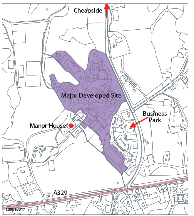
Silwood Park lies within the Windsor Great Park and Woodland and includes the Silwood Park Biodiversity Opportunity Area, representing an opportunity area for habitat creation and restoration. There are a number of Grade II listed buildings on the site, including the original Manor House and South Lodge, and a number of other buildings, many of which are dated and require modernisation.
We understand from Imperial College London and their agents that ICL wish to develop their education/research work at Silwood with a vision of becoming a major international hub for scientific research. To achieve this will require major changes and substantial investment and they therefore wish to make a number of changes to the designation of the Silwood site, to:
ICL’s broad vision is strongly in keeping with the type of employment considered appropriate for our area. Their proposal however to develop some of the land for residential use runs counter to Green Belt policy.
Silwood Park’s location is at the heart of our NP area, lying between Sunninghill, Cheapside and Ascot. If access were provided through the site with cycle routes and footpaths it could make a significant contribution to our aim of improving cycle and pedestrian connections between these villages.
To encourage ICL’s overall plans for the future of Silwood Park but retain it as an Education and Research site which also provides other and associated employment.
To protect the Green Belt from development.
To ensure that any redevelopment delivers public cycle routes and footpaths to connect the site to the villages of Sunninghill, Cheapside and Ascot, and mitigation measures for any harmful increase in traffic.
NP/SS9.1 In accordance with our policy NP/H1, a Development Brief is required. Any relevant development proposals must be in line with this Development Brief and must be accompanied by a Statement of Community Consultation, as set out in Appendix D.
NP/SS9.2 Development proposals to redevelop all or part of the Major Developed Site of Silwood Park may be permitted subject to the following considerations:
NP/SS9.3 Proposals to provide on–site accommodation on Silwood Campus for students and staff may be permitted subject to considerations of traffic impact and design.
< Previous | ^ Top | Next >