
NOTE: This Neighbourhood Plan is to be read as a whole. Development proposals will be required to fulfil the conditions of all applicable policies.
The National Planning Policy Framework (NPPF) states that there are three dimensions to sustainable development: economic, social and environmental, all of which are important.
NPPF para 15 states that while all Plans should be based on and reflect the presumption in favour of sustainable development, which we fully support, policies in the Plans will guide how the presumption should be applied locally.
In evaluating locations that are most suitable for housing development, we have given preference to those that are:
We’re also seeking to deliver a mix of housing types so that we can “meet the needs of present and future generations” and ensure we support the community’s needs and “its health, social and cultural wellbeing”.
In order to “protect and enhance our natural, built and historic environment”, we have designed policies intended to ensure that:
While we are primarily a residential neighbourhood, there is a strong desire in the community to also “build strong, responsive and competitive economies” and “support growth and innovation”. With this aim, we are seeking to retain at least the current level of job employment in our area by:
We also wish to ensure the future viability and vitality of our village centres by policies that protect and encourage a wide variety of smaller retailers to flourish.
This document sets out local considerations for delivering sustainable development in our NP area. Development proposals should meet the requirements of all relevant policies in this Neighbourhood Plan and be in line with Borough and national policies.
5.2.1 Housing overview
It is national government policy to actively encourage sustainable development; the nation needs more homes. This Neighbourhood Plan sets out to deliver a significant number of new homes during the Plan period in a way that reflects local needs and the wishes of residents.
At the time of writing, the only guideline available for the total number of new homes that have to be provided for across the Borough is a very provisional housing target of between 290 and 350 dwellings per annum, set before the publication of the 2011 Census. RBWM is currently working on housing needs analyses for the entire borough. When completed this will inform the development of the Borough Local Plan (BLP) and determine the new housing that will be required over the next 15 years for the Borough and for our area.
New housing completions in the Borough for the years from 2001–02 to 2011–12 have averaged 334 per annum. Completions in our NP area during the same period have averaged 60 dwellings per annum – 18% of the Borough’s total. It is unlikely that our future housing need will be any less.
With the Crossrail line due to commence operation into Maidenhead by December 2019 and the plans for the rejuvenation of Maidenhead Town Centre well advanced, it is expected that the primary focus for new development will be in the Maidenhead area. Development is also expected in Windsor, the second largest town in the Borough. Our area however is a popular place to live and it is likely that we will see continued demand for new housing here.
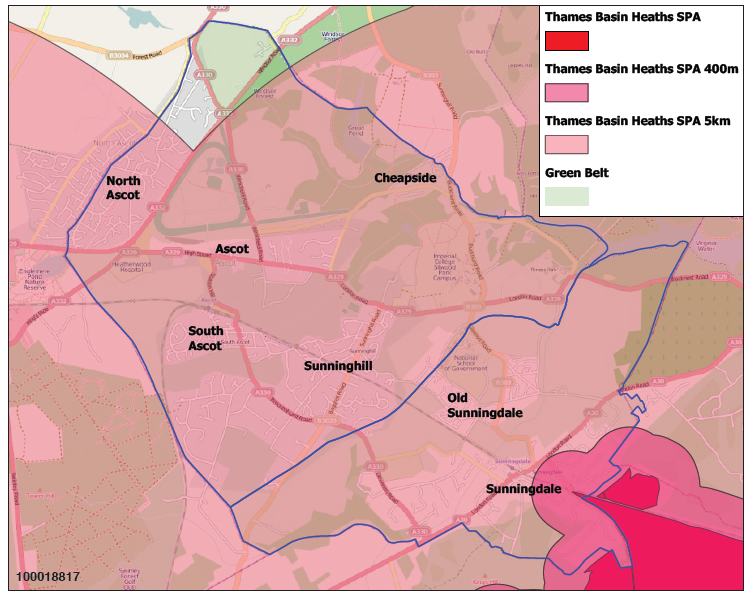
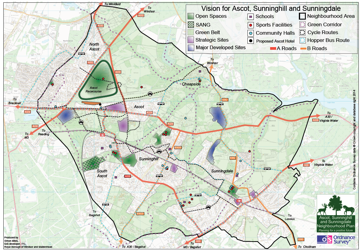
The two major constraints to new development in our NP area are that 66.5% of the area is in Green Belt (see Map 1) and that virtually all of it lies in the zone of influence of the Thames Basin Heaths SPA.
Thames Basin Heaths SPA
A SPA is a European designated site and is an area of land, water or sea which has been identified as being of international importance for the breeding, feeding, wintering or the migration of rare and vulnerable birds. Thames Basin Heaths SPA is a network of internationally important heathland sites to the south east of our area.
The significance of this on housing development in our area is that to mitigate any effect of additional new dwellings within 5km of the SPA, a Suitable Alternative Natural Green Space (SANG) must be provided as a way of reducing recreational pressure on the SPA, as well as a financial contribution towards strategic access management and monitoring. Within 400m of the SPA (as the crow flies) there is a presumption against residential development to avoid any significant effect on the integrity of the nearby SPA. This 400m zone affects the South East corner of Sunningdale parish (see Map 2). So the number of houses that can be built in our Plan area is constrained by the availability of SANGs.
Map 2: Zone of influence of Thames Basin Heaths SPA
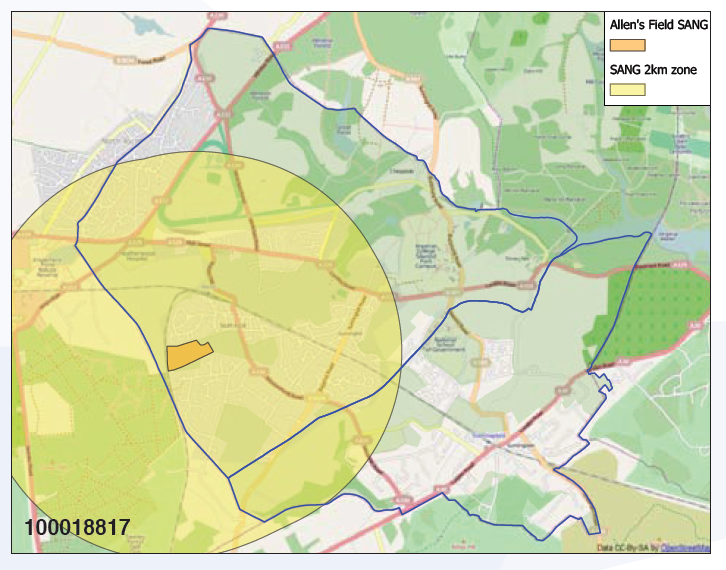
In October 2011, RBWM designated Allen’s Field in South Ascot as a SANG which allows for 462 dwellings to be built. As at March 2013 a total of 105 planning permissions (as agreed by Natural England) were able to be counted towards this overall total.
The 462 dwellings allowed by the Allen’s Field SANG will not suffice for the amount of housing we are projecting for the period of this Plan and additional SANG(s) will be required. During the consultation process, a couple of sites have been identified as possibly having the potential to become SANGs. A Project is included in Section 9.4 of the Plan, which is an initiative to encourage consideration of potential SANG sites and we are confident that SANGs will come forward during the Plan period to enable development to take place. This is especially important to Sunningdale, as the Allen’s Field SANG zone does not stretch to cover that area.
Map 3: Extent of Allen’s Field SANG Zone
In Spring 2013, development started on a new state-of-the-art care village at Lynwood, in Sunningdale just on the borders with Sunninghill. This is owned by BEN – Motor and Allied Trades Benevolent Fund and will deliver an additional 133 dwellings for our area, an important contribution towards our housing numbers.
In our NP area, much of our housing land supply in recent years has come from windfall sites – sites which were not specifically earmarked for development in the Borough’s plans. The type of piecemeal development that this creates has given rise to the concern that it is causing harm to the character of the area. Such small-scale speculative development also makes it more challenging to secure the funding necessary to deliver infrastructure improvements.
5.2.2 Economy Overview
While our area is primarily residential, there are a number of sites in it which provide jobs. The largest current employers are in the healthcare, education and hospitality sectors, all of which have a large proportion of their workforce coming from outside our NP area.
There are a small number of storage and/or distribution centres, some of which require access through residential areas and/or along roads used by school children.
The range of office accommodation in the area includes a variety of floor plates, age and quality and, although there are pockets of unoccupied office space, a large proportion of available office space is occupied. It is relevant though to note that there is a considerable amount of vacant office space within 10 miles of the Neighbourhood; this is before any new space that may arise from the vacating of the Defence Evaluation and Research Agency (DERA) site in Surrey.
Retail represents an important sector of employment in our NP area. The retail offering is concentrated in our three main village centres of Ascot, Sunningdale and Sunninghill and we expect this to continue to be the case.
5.2.3 Transport Overview
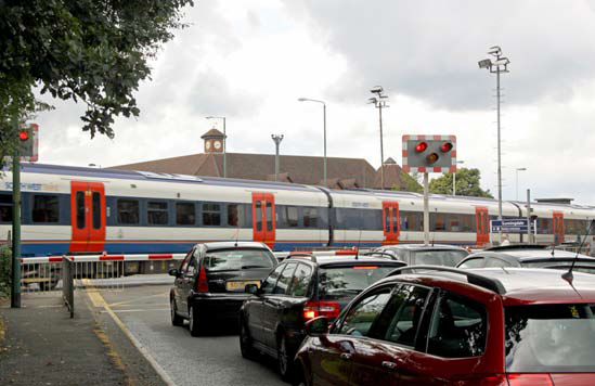
We have two railway stations in our NP area; one in Ascot and one in Sunningdale. Both are on the Reading to Waterloo line, with Ascot also having services to Guildford.
Map 4: Transport Map (Public) of NP Area
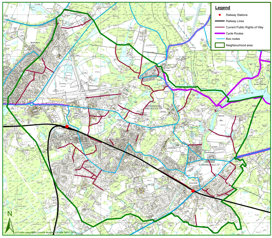
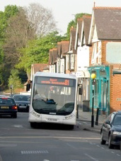
We have infrequent bus services, especially during the peak morning and evening periods. Community consultation also highlighted poor public transport links to neighbouring towns, particularly to Windsor.
Currently, there is just one short length of cycle route that comes in from Bracknell and goes as far as Ascot Racecourse. While there has been an increase in the provision of cycle storage at both stations and in a number of village centres, without cycle routes and with highly trafficked roads, there is limited encouragement for people to cycle.
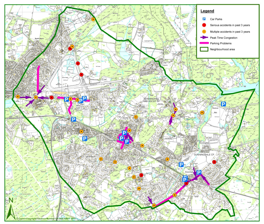
Limited public transport places greater reliance on use of the car. Traffic congestion and parking were recurring themes in the feedback from all our community consultations.
Map 5 shows the areas of peak time congestion and parking problems, which are clearly clustered primarily around our Victorian village centres. Heatherwood roundabout is also a traffic congestion hotspot with the two major local A-roads converging.
Although there are a number of car parks shown on the map, many of these are small and fill to capacity.
Even though this Plan encourages use of more sustainable means of transport, with the level of expected new development it is clear that more parking provision will be required and substantial improvements to the road infrastructure.
Map 5: Transport Map (Cars) of NP Area
We considered all three of our major villages and evaluated which could best support and benefit from increased development in ways that will enhance our neighbourhood while protecting its character and green and leafy feel. We also examined the larger sites in our Plan area to identify those which have the greater potential for sustainable development.
Our strategy is to concentrate new development where it is most appropriate and where it can best deliver the type of development the local community is comfortable with and the infrastructure improvements we need.
Another cornerstone of our strategy is to require Development Briefs for all sites over a certain size threshold and for major strategic sites as a useful tool to ensure developer / community engagement early in the design process.
Windfall sites will still come forward and development on these will be welcomed, but within clear parameters set by policies in the Plan, to ensure that they deliver the mix, type and design of housing that is appropriate to the character of our area.
5.3.1 Our Three Village Centres
Ascot
The development of Ascot as a centre has been constrained by the fact of the racecourse on one side and Green Belt on the other. This has resulted in a somewhat one-sided centre that is considered by local residents and visitors as having little to attract them, and there is strong support from the community to see Ascot improved and enhanced.
Retailers in Ascot High Street, unless serving the needs of racegoers, suffer from the serious traffic and pedestrian congestion during the (approx) 26 days of racing.
We have a unique opportunity through Neighbourhood Planning to develop Ascot into a thriving and vibrant centre, enhancing the local economy, providing a considerable number of new houses in a sustainable location close to a key transport hub, and delivering direct benefits to the community in the form of a community centre and public open space.
A key cornerstone of our overall Plan, therefore, is to focus new housing and retail development around Ascot.
Sunningdale
Sunningdale has already seen considerable development along its main A30 artery, resulting in serious traffic and parking issues and an undesirable change to the character of some of the area. We need to strike a fine balance of delivering the most sustainable development that will support the local economy while not further harming the character of the area or aggravating the traffic and parking problems, especially bearing in mind the likely impact of the DERA development in Surrey.
We are proposing modest–scale, sensitive mixed development around the retail centre of Sunningdale, while retaining its character.
Sunninghill
Sunninghill village is already under threat from traffic congestion, HGV deliveries and high parking demands, putting the character of the village and potentially also its economic viability at risk, as well as negatively impacting on the amenity of local residents. We therefore propose through Neighbourhood Planning to manage future development in Sunninghill to mitigate these negative impacts and there is a policy to this effect in Section 7.
Our focus for Sunninghill is to preserve and enhance the character of the village.
5.3.2 Strategic sites
As a second key cornerstone to our Plan, we have identified a number of larger strategic sites suitable for development in our Plan area.
Focusing development on these strategic sites brings a number of benefits, such as:
We have in Section 8 included policies on a site-by-site basis for all our strategic housing and job sites. Housing numbers for each site and the amount of additional employment or retail space will emerge through the process of consultation required by our policy on Development Briefs (Section 6.2.1; NP/H1) and all our strategic site policies.
Map 6: Strategic Sites (see table)
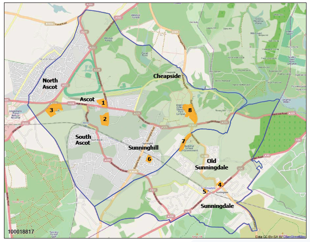
| Strategic Site | Proposed Use |
|---|---|
| 1. Ascot Centre / High Street - “Ascot Village” | Significant Housing and Retail; options include some general employment |
| 2. Shorts Recycling Transfer Station site | Employment or alternative uses |
| 3. Heatherwood site | Healthcare facility plus significant Housing |
| 4. Sunningdale Broomhall Centre | Retail and Housing; options include some general employment |
| 5. Sunningdale Station & Waitrose Car Parks | Commercial; small Retail |
| 6. Gasholder site | Significant Housing; options include Education use |
| 7. Sunningdale Park | Employment plus potentially housing |
| 8. Silwood Park | Education, research, other associated employment and associated residential |
Note:The definition of “Employment” can be found in the Glossary section of this Plan.
With the number of planning permissions already granted and to be built, a major focus on development in Ascot, managed, creative development in Sunningdale, the identified strategic sites and windfall sites, we are confident that we are securing a sustainable level of future growth for our area and its economic viability.
5.3.3 Development Briefs
The requirement for all sites larger than 0.4 hectares which include 10 or more dwellings, and for our strategic sites, to provide a Development Brief is an important strategy of our Plan.
A Development Brief is a very useful tool through which developers can set out their proposals for new development in sufficient detail to allow the community to understand what is being proposed – including dwelling types being proposed, design, issues of access and infrastructure and any likely impact on trees (see Appendix C for full details).
A meaningful consultation process can then be engaged in and local views can be incorporated into the design of the development.
Planning applications for developments that require a Development Brief must be accompanied by a Statement of Community Consultation which sets out how the community were consulted, a record of their views and how these have been taken into account in the proposals being submitted (see Appendix D for full details).
5.3.4 Economy
With the high cost and restricted availability of land in our NP area due to the Green Belt and infrastructure constraints, we do not expect any development applications for major new economy sites to come forward.
There is demand for light industrial units and spaces suitable for small and micro businesses and we propose to encourage these through our general economy policies.
The retail offering in our area will continue to be concentrated in our three village centres of Ascot, Sunningdale and Sunninghill and our strategy is to seek, in so far as it is possible, to protect the variety and range of retail available.
5.3.5 Environment
The protection of the green and leafy character of our area, of the Green Belt and open spaces are a high priority for the local community. Our strategy of concentrating development on the larger strategic sites adds a greater degree of certainty to ensuring this protection, together with policies to protect trees and prevent inappropriate development on open spaces and gardens.
Design guideline policies aim to encourage good design that retains and improves the area’s character, the streetscape and the natural environment.
The goal of preserving and enhancing important habitats and the biodiversity of our area is addressed through policies on biodiversity and green corridors.
5.3.6 Green Belt
66.5% of our Neighbourhood Plan area lies in the Green Belt and there is popular support for its fundamental aim of preventing urban sprawl by keeping land permanently open.
The NPPF is clear in its support for the Green Belt, emphasising its importance and its essential characteristics of openness and permanence (para 79). It also states that inappropriate development should not be approved except in very special circumstances (para 87) and that very special circumstances will not exist unless the potential harm to the GB is clearly outweighed by other considerations (para 88).
Areas designated as Green Belt will continue to be protected by Borough and national policy. While the community has shown strong support for protecting these areas, it is beyond the remit of a Neighbourhood Plan to seek to change national Green Belt policy and it is not appropriate or necessary to have a policy that repeats what already exists.
It should also be noted that there are a number of areas in our NP which represent existing development in Green Belt. This includes, for example, all of Cheapside village which is residential, part of Ascot Station area and a number of our identified strategic sites: a part of Heatherwood site, and of Shorts Recycling Transfer Station site, and parts of Sunningdale Park and Silwood Park.
The NPPF (para 89) allows for limited infilling or redevelopment of previously developed sites provided it would not have a greater impact on the openness of the GB and the purpose of including land within it than the existing development. Our Neighbourhood Plan cannot prevent these sites from being re-developed but, instead, we have tried to positively influence the shape of any such future development that may take place.
5.3.7 Transport
Public consultations have also shown considerable support for better – and especially safer – facilities for cyclists and pedestrians, while at the same time pragmatically recognising that we are a car-based community and this is unlikely to significantly change.
We have tried through our policies to provide for achieving a better balance between the sometimes conflicting needs of these user groups, while also encouraging less reliance on cars.
Specific policies on parking aim to at least mitigate the impact on increased parking demand from new development, while our strategic site policies aim to deliver increased parking capacity in Ascot and Sunningdale.
Traffic congestion is a challenge in our area and cannot be fully addressed through a Neighbourhood Plan. We have identified two related Projects: the first is to deliver a Village Hopper Bus Service; the second to work with RBWM Highways Department to find ways of improving highways management and addressing traffic congestion in our area. Many of our strategic site policies include a requirement to provide safe cycle and pedestrian ways to link different parts of our area and a specific cycle policy aims to create cycle routes between the villages.
5.3.8 Community
We have conducted considerable research into whether the community infrastructure, in the shape of schools, GP surgeries, community halls and open spaces, will be able to cope with the projected increase in development – a concern repeatedly expressed by the community during consultations.
It is likely that we will need a significant number of additional primary school places in our area during the Plan period and we have defined a Project to try to address this.
Existing GP surgeries currently have adequate capacity to take on new patients and a number are interested in expanding their premises and/or their services, which we support.
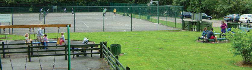
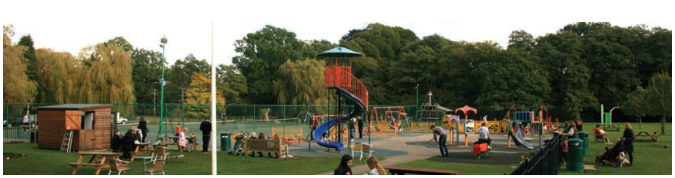
An easily accessible community hub and public open space are considered important to the local community. Sunningdale is reasonably well served in this respect through its Village Hall and Broomhall Recreation Ground but its commercial centre lacks a public square. Sunninghill has Cordes Hall which is being opened up more for community use. Victory Field is a popular sport and recreation ground that serves both Sunninghill and Ascot but is not at the heart of either and has some issues in relation to access, especially for pedestrians. There is a lack of a public open space to serve residents at the southern end of Sunninghill village and there is a major need and desire for a community hub and open space in the centre of Ascot. Our policies and projects seek to address these needs.
The start date we have adopted for our Neighbourhood Plan is April 2011 as being the date when the Steering Group was formed and work on developing the Plan started.
An April start also allows us to fit in with the way RBWM monitors development, in financial years (April to March).
The Plan Period is 15 years, so it is intended that our Plan runs for the period from April 2011 until March 2026.
We recognise also that the Plan will be delivered and implemented by different stakeholders and partners and that it is not a rigid blueprint but instead it provides a framework for change through its vision, strategy and policies.
As new challenges and opportunities are likely to arise over the plan period, the intention is for the Neighbourhood Plan to be reviewed every 5 years.
During the development of our Neighbourhood Plan, a number of initiatives were proposed to enhance our neighbourhood and way of life, which don’t fall within the spatial remit of town and country planning or which cannot be delivered through a Neighbourhood Plan. We nonetheless wish to document these as being part of the overall picture of what the community wishes to see delivered for our area. We have called these initiatives “PROJECTS” and have included them in section 9 of this document.
We propose to drive these projects forward as members of the community, working as needed in partnership with the Borough, the Parish Councils and/or other appropriate partners. It is the intention that these projects should be financed where necessary by the Community Infrastructure Levy (CIL) or S106 monies.
< Previous | ^ Top | Next >