
What we would like to see
Although we are now (2015) a community with a population of 11,375 residents, the great majority of our residents believe that Bookham is a village. The village “atmosphere” and “feel” are cherished characteristics. These characteristics are generated by the sense of spaciousness from being surrounded by countryside: by the variety of community clubs, societies and facilities: by the range of independent shops: by the range of designs of housing and the abundance of trees and green spaces interspersed amongst them.
Bookham Vision, referred to earlier, identified almost universal concern that infrastructure and service improvements have not kept pace with incremental housing development and there is significant feeling that this problem will only get worse without specific action. There is a general desire that any future development should not proceed unless action to meet infrastructure needs is committed and implemented at the same time.
Bookham is seen as a family oriented community and most residents would like it to remain so.
There is concern that the majority of recent developments for new homes, or the extension of existing properties, has created an increasing number of large and expensive homes. Bookham Vision identified that the community at large strongly favoured development that produces smaller, less expensive homes suitable for the retired to downsize to or for younger families.
Bookham Vision also noted that a large majority of residents wanted the Green Belt land surrounding Bookham to be protected.
The demands we face
Government policy on planning is set out in the National Planning Policy Framework (“NPPF”). It is the definitive framework within which our NDP has been prepared. Although reference to specific NPPF paragraphs is not always made, it should be assumed that this NDP has taken them into consideration and aims to support their intent.
Our plan has also to be in general conformity with the MVDC’s existing plans which, in our case, are:
The Mole Valley District Council Core Strategy (“Core Strategy”). This covers the period until the year 2026 and was adopted in 2009.
The Mole Valley District Council Local Plan 2000. This is an older plan which was designed to meet the District’s housing requirement up to the year 2006.
The Core Strategy did not completely replace the Local Plan 2000, and so policies from both had to be taken into account in our NDP.
The NPPF requires the planning system to contribute to the achievement of sustainable development. The Core Strategy sets out strategic policies to deliver sustainable development within the District and our NDP sets out policies which make a more local contribution to this goal. MVDC has assessed the NDP policies against this requirement of the NPPF.
The Core Strategy requires “....3,760 new homes to be provided in the most sustainable locations in the District by 2026.”. The Core Strategy also states that “New development will be directed toward previously developed land within the areas of Leatherhead, Dorking (including North Holmwood), Ashtead, Bookham and Fetcham”.
MVDC has made good progress towards its target to provide 3,760 homes by 2026. Latest figures (2015) show that 1,970 new homes have been built in the District since 2006. There are known sites for a further 1,150 new homes.
MVDC have a remaining requirement of approximately 640 new homes by 2026. Windfall sites which become available within Bookham will contribute to these. |
Population evolution
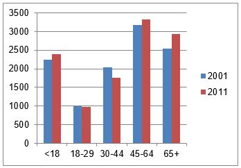
The population increased from 11,007 to 11,375 between the census of 2001 and 2011, 368 larger. In the same time the number of residents over the age of 65 increased by 384. This trend is set to continue. Evidence shows that, as families grow older, children tend to leave, but parents and older residents tend to stay. This has resulted in larger homes being occupied by fewer people, and those who would wish to move to a smaller property (“downsize”) find this difficult as there is not a supply of suitable smaller homes available. Equally, the lack of availability of smaller housing reduces the opportunity for young families to establish themselves.
Constraints
Green Belt
Bookham is bounded on the north, west and south by Green Belt land. To the east lies Fetcham, and there is no gap between the two communities. The north is bounded by the railway line beyond which is Bookham Common, an area owned by the National Trust, and a Site of Special Scientific Interest. On the south side are the North Downs Surrey Hills, the majority of which is also classified as an Area of Outstanding Natural Beauty. Polesden Lacey, a property owned by the National Trust, is in this area
On the western side the majority of the land is open and privately owned. The openness creates a “perceived” gap between the villages of Bookham and Effingham (which lies in Guildford Borough and not Mole Valley) although there are some buildings immediately on each side of the boundary in some places.
The Green Belt boundary was defined in the 1950’s and since then all of the development in Bookham has been within the built up boundary. Major developments took place in the 1950s and 1970s, taking most of the available open, non-Green Belt land. Subsequently development of surplus garden land, disused business properties and the redevelopment of small properties in large gardens has been the source of the new homes built in recent years. From April 2001 to March 2014, these development opportunities (sometimes known as “windfall sites”) produced 236 extra homes in the village. These development opportunities are, naturally, becoming scarcer. There are no old business premises (sometimes known as “brownfield sites”) available within Bookham which would not require a change of use and a potential loss of local employment in order to accommodate new homes.
Infrastructure
The road system has very limited room for improvement. There are two “through” roads running east to west. The southerly A246 carries a high volume of traffic, particularly at rush hour times. The northerly Lower Road has residential properties on either side for the majority of its length. All but one of the six north-south roads which connect the A246 and Lower Road are very narrow and suitable only for single vehicle movements along parts of their length.
Parking is available in three recognised public car parks, and there are designated parking places in the High Street and Church Road. Despite this, many vehicles are also parked in residential roads near to the village centre.
There are some limited designated cycle tracks although there is a substantial network of paved and unpaved footpaths which are used, albeit illegally, by cyclists.
A spring line runs along the Lower Road between the chalk of the North Downs to the south and the London clay to the north. At times of heavy rain the springs produce a significant outpouring of water which overwhelms the drainage system causing local flooding. There are other recognised flood spots that give rise to localised flooding at times of heavy rain.
There are infants/junior schools in the village but no state secondary school, the nearest being the Howard of Effingham Academy, which is just outside the village but in the Guildford Borough Council planning area.
There are two doctors’ surgeries which have a total of some 18,500 patients, significantly more than the resident population.
< Previous | ^ Top | Next >