
Development in Ashtead has spread out from the original village centre in its south-eastern corner. Mole Valley’s 2010 Built-Up Area Character Assessment (see Appendix 7) identifies ten separate character areas, each with varying designs of residential property and differing density levels that combine to form a harmonious and varied environment.
Figure 7 Ashtead from the Air

There are many public rights of way around Ashtead, which link residential areas to each other, to the main shopping areas, to transport facilities and to the open green space within and around the village. This network is a key asset that must be protected and enhanced.
Although not the centre of Mole Valley’s economic activity, Ashtead’s population at 14,169 (2011 census) is the largest within the District and it is forecast 1 to increase to nearly 16,000 by 2026. In 2011, 43% of the population was in the 50-plus age group and population projections indicate that by 2026 this age group will have risen to nearly 50% of the total, while the proportion of under-18s will have remained constant at 22% and the 18-49 age group will have declined from 35% in 2011 to 29% in 2026.
Due to the constraints on land availability, the relatively small expected increase in housing provision in Ashtead in the years up to 2026 will not be sufficient to meet the demands of the village’s existing and increasingly elderly population. The projected overall increase in the population will further exacerbate the problem. However, during 2015, developers have recognized the need for smaller properties in Ashtead and there have been two successful planning applications made which will result in smaller residential accommodation: a Churchill development of 33 flats on the Leatherhead Road and the conversion of offices to 19 flats in The Street.
There has also been a significant amount of infilling but there are no identifiable larger development areas within Ashtead other than the land at Murreys Court (1.85ha between The Murreys and Agates Lane), which is allocated as a housing site in the Mole Valley Local Plan 2000.
The capacity of the site and the date at which it may become available is uncertain. There are also a number of constraints, including a Grade II listed barn within the site and a number of Tree Preservation Orders. Nevertheless, the site is recognised in this NDP as a site where residential development would be supported in principle, in line with the design guidelines set out in Appendix 11 of the Mole Valley Local Plan 2000. These design criteria remain applicable and should be addressed as part of the development of future planning applications. The Local Plan appendix is reproduced as Appendix 4 of this Plan.
Figure 8 Murreys Court on Agates Lane

It has also been identified that there is an opportunity to enhance pedestrian accessibility in this part of Ashtead by providing a footpath connection through the site, at such time as it becomes available for development. Subject to any issues concerning local policing, the following policy seeks to secure this benefit, which would be consistent with the local objectives identified in the Transport report for this NDP.
Policy AS-H1 provides a policy context to secure this new footpath connection. Once established it will provide a convenient route between The Murreys, the new development on the site and The Street. The footpath and any associated lighting should take account of the MVDC Designing Out Crime Supplementary Planning Document (December 2011) and any specific design requirements requested by Surrey County Council with regards to a safe crossing point across Agates Lane.
Policy AS-H1: The Land at Murreys Court
Residential development of the Murreys Court site should include the provision of a new public footpath that will connect The Murreys and the site with the existing footpath between Agates Lane and Skinners Lane.
Almost 50% of Ashtead’s housing lies in low-density detached properties and 40% of all homes have four or more bedrooms but the greatest demand for housing in Ashtead is for 2 or 3 bedroom accommodation 2. The percentage of people looking to move into a house with 2 or 3 bedrooms is significantly greater than the proportion of current properties in Ashtead, which have that number of bedrooms. The need for smaller accommodation will be further increased by an expected reduction in the average size of households and ongoing demand from those on the housing register.
MVDC’s existing Policy CS3, clauses 1 & 2, relating to the mix of housing and the need to provide a balanced housing market is not proving effective in ensuring that priority is given to increasing the number of two and three bedroom homes in Ashtead. The combined effect of recently built housing and changes to existing housing between 2011-2014 means that the net increase in housing stock of 3 or fewer bedrooms during those 3 years is just 17 dwellings. MVDC’s policy was based on the East Surrey Strategic Housing Market Assessment which made the recommendation “that the council should encourage a mix of market housing comprising three bedroom homes (50%); two and four bedroom homes (20% respectively): and one bedroom homes (10%). Evidence of demand versus housing stock that is specific to Ashtead indicates that the 70% mix of 2 and 3 bedroom homes should be equally split between the two sizes of dwelling.
Policy AS -H2 sets out a policy approach towards addressing this matter. It attempts to strike a balance between allowing the market to deliver high quality housing for five or more dwellings in an innovative style and providing housing to meet the needs for smaller dwellings. Plainly a wide range of sites may be affected by this policy. As such it sets out to ensure that the developments concerned are consistent with their locations within the Plan area.
There may be circumstances where the viability of developing a site may conflict with the successful implementation of this policy. In these circumstances developers will be expected to adopt an open book approach with the District Council as part of the determination of the application.
The second part of the policy provides support for proposals that propose the provision of a greater number of 1/2/3 bedroom and a lesser number of 4 or more bedroom properties than those expected from the application of the first part of the policy.’
Policy AS-H3 provides a similar approach for smaller housing sites to that adopted for policy AS-H2. The viability issues will also apply to these potential smaller sites.
Policy AS-H2: Balancing
the housing mix
Policy AS-H3: Infill
and smaller sites
On housing developments of between 1 to 4 dwellings:
In all housing developments of this size the mix of housing types should also be consistent with achieving a good layout and design in relation to the immediate locality.
Much of the demand for smaller properties comes from older residents wishing to downsize but remain living in Ashtead and there is significant demand for retirement properties and bungalows, which cannot be met at present.
Figure 9: Central Area

At existing levels, the provision in the village of appropriate independent living accommodation for people over 75 is at less than 50% of relevant guidelines. The predicted large increase in this age group will lead to a much greater demand for this type of accommodation.
Policy AS-H4: Central Area Developments
Within the Central Area of Ashtead (see Figure 9 and a larger map in Appendix 3) developments which provide 1, 2 or 3 bedroom properties will be particularly supported.
It is the aim of the NDP to increase the amount of smaller dwellings in Ashtead; however it is recognized that it is important to maintain character and it is necessary to balance Policies AS-H2, AS-H3 and AS-H4 in accordance with policy AS-H5.
Implementation of Policies AS-H2, AS-H3 and AS-H4 must also include provision of Affordable Housing to meet the requirements laid out in MVDC Policy CS4.
In addition to the ten identified character areas within Ashtead there are also:
Policy AS-H5: Maintaining
Built Character
In accordance with Mole Valley Policies CS1 & CS14, developments must be visually integrated with their surroundings and designed to have regard to the character of the local area and street scene (see also policy AS-En3).
Implementation of Policy AS-H5 will follow the guidance in MVDC’s Built up Areas Character Appraisal for Ashtead. The policy is not intended to preclude contemporary design where it can be achieved in a manner which integrates well with its surroundings. The policy applies throughout the Plan area.
When new developments are undertaken it can be in the developer’s interest to provide minimal off-street parking so as to maximise the space for residential development. MVDC is the planning authority and their policy is based on Surrey County Council (SCC) guidance, which is not mandatory.
There are many roads in Ashtead where excessive on-street parking restricts the passage of traffic and pedestrians. Cars are regularly parked on verges, footpaths and cycle ways, sometimes causing damage. Several roads have had parking restrictions applied by means of yellow lines and it is considered that future developments should not be allowed to worsen the on-street parking situation.
Multi-dwelling developments often have mostly allocated spaces, which are effectively owned by a particular resident, and relatively few visitors’ spaces. There is often a mismatch between the number of spaces allocated to a dwelling and the number of cars owned, leading to excessive on-street parking, congestion and empty spaces.
The SCC guidance has four different levels of provision depending on the character of the location varying from “Town Centre” (lowest level) to “Suburban edge/Village/Rural” (highest level). The proposed policy for Ashtead is in line with SCC’s second highest level of provision.
Policy AS-H6: Off Street Parking
Off-street parking is to be provided at residential developments in accordance with Table H6.
Table H6
| 1 and 2 bed flats | 1 space per unit |
| 1 and 2 bed houses | 1+ space per unit |
| 3 and more bed dwellings | 2+ spaces per unit |
On housing developments of 10+ dwellings, there will be a requirement for allocated visitor parking spaces on the site amounting to an additional 20% of the figure for the development calculated from Table H6.
As stated in Section 2.2, Mole Valley is an economically prosperous district. There are approximately 5,000 firms in Mole Valley employing around 46,000 people. The service sector provides the majority of the employment opportunities with a number of national and international companies having their headquarters in the District.
Unemployment rates are historically amongst the lowest regionally and nationally. As a consequence, local businesses often find it hard to recruit employees, especially for lower paid jobs and in some parts of Mole Valley there is a disparity between jobs available and the skills of residents; e.g. Ashtead Hospital finds it difficult to employ local nursing staff.
Figure 10: Surrey's Workforce
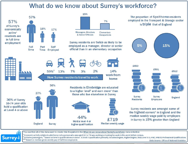
The number of residents running a business from their home is difficult to estimate. The census shows that ten percent of the working population in Ashtead, over eleven hundred people, work mainly from home and there are twelve hundred self-employed in the village. It is therefore not unreasonable to estimate that there are 800-900 businesses being run from Ashtead homes.
Data from the Office for National Statistics (ONS) for 2004 show that there were over 500 VAT-registered businesses in Ashtead, of which over 200 had a single employee.
The study into the District's town, local, district and village centres which was commissioned by the Council (MV Core Strategy para 2.47) recommended that the forecast increase in available expenditure by people currently using the District's centres would support an increase in comparison and convenience goods floorspace over the next ten years with the increase in everyday shopping (convenience) floorspace focused on Ashtead and Dorking. The study also forecast that there is likely to be additional available expenditure to support more leisure facilities in the town centres. There is evidence from the study that a high proportion of residents in Ashtead travel outside of the village for their convenience shopping requirements. The study recommended that the addition of a new food store in Ashtead could have the potential to “claw back” trade to the village and reduce the distance local residents have to travel for convenience shopping.
The economic aim of this NDP is to:
These aims are generally already adequately supported by existing MVDC policies and do not need to be amended or strengthened.
The shopping areas comprising The Street and Craddocks Parade are identified as Local Shopping Centres under Mole Valley Local Plan Policy S5. This provides the following safeguards:
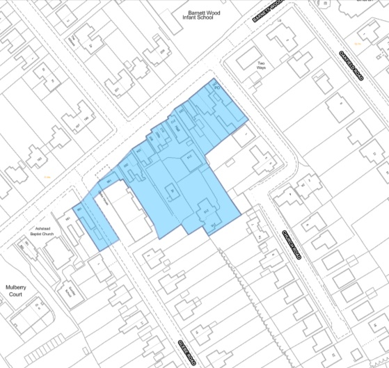
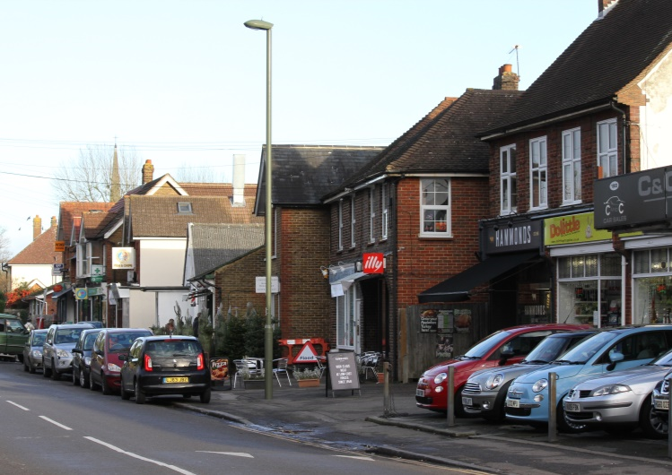
Policy AS-Ec1 adds the shops comprising numbers 196-230 Barnett Wood Lane to the two existing Local Shopping Centres in Ashtead, to provide a similar level of protection.
Figure 11 Barnett Wood Lane Shops
Policy AS-Ec1: Designate Barnett Wood Lane shops as a Local Shopping Area
The area of shops comprising numbers 196-230 Barnett Wood Lane is designated as a Local Shopping Centre. Within the area defined on the map at Figure 11, proposals involving changes or use or increases in shopping floor space will be considered against Mole Valley Local Plan Policy S5 and Core Strategy Policy CS8, as reproduced in Appendix 5 of this Plan.
In order to further encourage the use of these shops there is a need to improve the availability of short-term parking along this stretch of Barnett Wood Lane. This falls under the remit of Surrey County Council as the Highways Authority and is outside the scope of this NDP. A suggestion to create parking bays by using part of the current pavement area is under discussion between the shopkeepers and MVDC.
Driven by economics and current government policy, there are a number of business premises which are being considered for conversion to residential use. This policy was originally a temporary measure, but the government has recently announced that they intend to make the Permitted Development rights permanent.
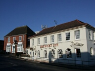
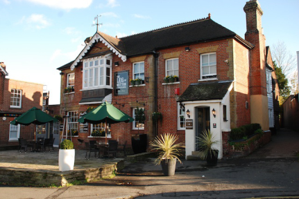
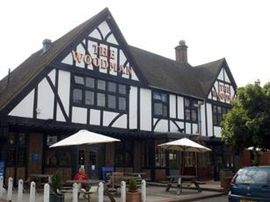
The three public houses in the village, The Leg of Mutton and Cauliflower, The Brewery Inn and The Woodman, should be regarded as centres within the community and afforded additional protection against any change of use. This is in addition to the other community assets described within the Infrastructure section. Policy AS- EC2 indicates that these facilities will be safeguarded in accordance with policy CS17 of the adopted Core Strategy.
Figure 12 The Brewery and Leg of Mutton & Cauliflower on The Street and The Woodman, Barnett Wood Lane
Policy AS-Ec2: Existing Public Houses
The Leg of Mutton and Cauliflower(48 The Street), The Brewery Inn, (15 The Street) and The Woodman, Barnett Wood Lane, should be regarded as valued community facilities and proposals which would result in the loss of any of these existing public houses will not be supported.
At the time of writing this document, the old petrol station site on The Street remains undeveloped. This site was bought by Tesco with the intention of building a local store and has planning permission (MO/2009/1322) for a supermarket with nine flats above. That planning permission is still valid and the site is currently up for sale. Should a new development proposal be submitted, it is important that it encourages shoppers to The Street and does not dominate the retail area in a manner which would undermine the viability of existing shops. To that end the following policy incorporates many of the conditions of the existing permission, in particular:
Policy AS-Ec3: 53-57 The Street
Proposals for the redevelopment of 53-57 The Street for retail purposes will be supported subject to the following criteria:
In the above policy “comparison goods” refers to goods such as clothes and electrical equipment, for which the consumer generally expects to invest time and effort into visiting a range of shops before making a choice. In contrast, convenience goods are goods such as food, newspapers and drinks, which tend to be purchased regularly and for which convenience of purchase is therefore important.
This section of the NDP draws on the Transport Report (see Appendix
7), which identifies areas of local concern based on evidence from Surrey
Highways Authority and MVDC who have the following District-wide objectives:
MVDC Objectives (Core Strategy Goal No. 4 regarding Transport)
Surrey Highways Authority Objectives
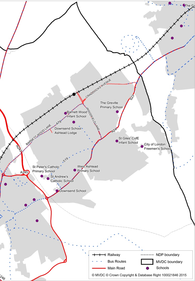
Ashtead suffers the problem of congestion caused by the high use of cars. The 2011 census showed that 57% of the population travelled to work by car, 20% by rail and only 1% by bus and 2% by bicycle. At commuter time, congestion is experienced along the two main roads running through the village (the A24 and Barnett Wood Lane / Craddocks Avenue), on the road giving access to the station and in the areas of the schools. Parking along the main roads and along feeder roads adds to the problem. The Craddocks Avenue problem is recognised in MVDC’s Transport Strategy and Forward Programme and a possible solution stated in 7.38 is to “Address congestion on Craddocks Avenue and provide alternative modes of transport”.
The station, situated at the northern edge of the village, has limited access by public transport therefore the car, for most, is the only option. Despite the expansion to the station car park there are insufficient places to cope with the large weekday numbers travelling to work by train. As a result, roads in the immediate vicinity of the station are filled by parked commuter cars.
Cycling within the village, both as a means of accessing the station and as a form of leisure, is on the increase. The increase in the number cycling to the station is to be encouraged because it helps take the pressure off the limited parking facilities. Cycling to the schools would help relieve the congestion in those particular areas of concern. However, cycling within the village is not necessarily easy because of the weight of traffic, narrow roads and sleeping policemen, especially along Barnett Wood Lane, one of the main thoroughfares of the village
There are increasing numbers of cycling accidents in the district as a whole but fortunately MVDC statistics show that the number of accidents involving all forms of transport within the village is minimal considering the size of the population. Nevertheless there is a need to make cycling be seen and rendered as a safer option within the village.
Ashtead station is on the mainline to both Waterloo and Victoria in London and is heavily used by local residents and those from the surrounding area. Its location at the northern perimeter of the village encourages many commuters to drive to the station, adding to traffic congestion and parking problems.
One particular bus route serves the northern part of the village and it provides a regular half hourly service but it is prone to unreliability. The southern half of the village, although served by more but less frequent bus routes has more limited coverage. The introduction of Real Time Passenger Information (RTPI) at key bus stops could help engender a greater sense of confidence in the use of the bus service despite its limitations.
Figure 13 Transport Routes through Ashtead
Issues with the bus service and station parking provision and cost further encourage many residents to commute by car.
The schools, apart from St Andrew’s and St Peter’s are not served by a local bus service, which adds to congestion in the surrounding areas during peak times.
There are no additional policies identified in this section because either the issues fall outside the scope of neighbourhood planning, or are covered by existing council policies. However this NDP identifies a number of projects which could help to meet the above objectives and which may be candidates for the neighbourhood portion of the Community Infrastructure Levy (CIL), once adopted. See Section 5 for details.
Ashtead is completely surrounded by Green Belt land which provides an abundance of natural and semi-natural greenspace, as well as land managed for agriculture and equestrian uses. To the north is Ashtead Common (an SSSI and NNR) and Ashtead Rye Meadows through which flows the Rye Brook which is in the process of being restored in order to reintroduce wild life and help offset local flooding (see detailed reports on both Environment and Infrastructure listed in Appendix 7). MVDC’s policies manage flood risk and direct development away from flood plains. Within the built-up area to the north, on either side of the station, are the open stretches of Woodfield; to the east of the village may be found Ashtead Park, an area of historic parkland. Much of the built character of the village is that of roads lined with mature trees, hedges, grass verges along the wider roads and mature trees around the houses with larger gardens.
Figure 14 Meadow Road, Ashtead
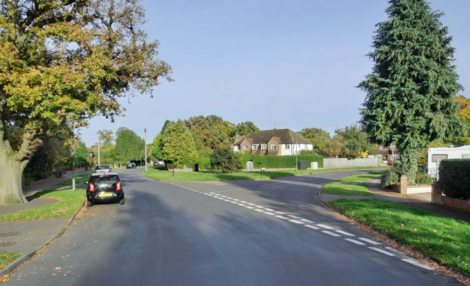
Although the impression of the village is of an overall green environment, a Mole Valley assessment of all the open space, sports and recreation facilities in the village in 2007 stated that there was a lack of provision of parks and gardens in Ashtead. There are however, large areas of natural and semi-natural green space in close proximity that may cater for the needs of the community.
The 2007 Mole Valley assessment designated a number of sports and recreation grounds within Ashtead as Strategic Open Space, thus providing a measure of protection to:
More recent research has shown that local sporting clubs are hard pressed for playing space. They are having to rely on using school playing fields when not in use by that particular school to help make up the shortfall or are having to go outside the village to neighbouring pitches.
The grounds of the remaining schools, City of London Freemen’s School, St Andrew’s and St Peter’s Catholic Schools, and Down send Preparatory School provide important facilities that should be safeguarded as far as possible.
Policy AS-En1: School Playing Fields
Proposals for the expansion of school premises should include the retention of playing field land for the use of the school for sports activities. Planning applications for the expansion of schools and associated facilities should also demonstrate that the retained playing field space has taken account of its potential for wider community use outside school hours.
MVDC’s Policy CS16 safeguards the provision of open space, sport and recreation facilities but it is recognised that difficult judgements sometimes have to be made about the balance between expanding schools and retaining open land for sport and recreation. The purpose of Policy As-En1 is to ensure that the benefit of such land to the wider community is taken into account when those judgements are made.
There is no obvious space for new sports and recreation facilities within the built-up area. However, outdoor sports pitches may be acceptable in the Green Belt in principle, depending on design issues.
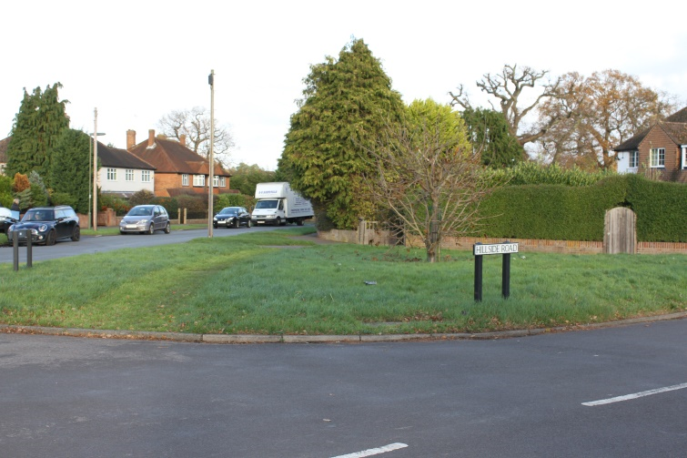
Part of the character of the village is that a high proportion of the gardens are extensive with large numbers of trees and shrubs. A number of developments within the village have been designed to include communal landscaped areas of grass for the use of the local residents. Grass verges along the wider roads, tree-lined avenues and areas of grass at road junctions also add to the green environment of the village. All these are an important aspect of the character of the village and are valued by the residents. They should therefore be retained and new developments should be encouraged to follow in the style of the green environment of the existing area.
Figure 15 Grass verges at Hillside Road
Policy AS-En2: Amenity Space
Areas of amenity grass, grass verges, trees and hedges should be retained to maintain the open character of the village. Development proposals should retain significant trees and hedges with public amenity value wherever possible.
As already stated, an MVDC Character Appraisal of Ashtead has identified ten character areas in the village. No area is built totally in one style and buildings range in size from original timber-framed cottages, to estates of houses built in the 1930s through to large Edwardian houses and yet the overall impression is of an attractive nature.
Figure 16 Parsons Mead
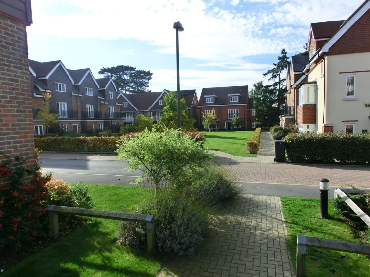
This mix has evolved organically over hundreds of years. There are many vestiges of the village being very rural where lanes are bounded by high hedges and large houses have appropriate large gardens with old established trees. The newest large development (Parsons Mead) has respected this sense of green space with the retention of its large trees and the provision of significant areas of grass. This mix of styles is an essential character of the village and the residents have expressed their wish that it is maintained by any new developments.
Policy AS-En3: Retaining Character
All developments should be visually integrated with their surroundings and designed with regard to the character of the surrounding area (see also Policy AS-H5).
Larger developments of five or more houses should include a mix of building styles where that is appropriate to the character of their surroundings.
All developments should be designed to include gardens and/or green space that maintains or enhances the character of the local area.
Implementation of Policy AS-En3 will follow the guidance in MVDC’s Built up Areas Character Appraisal for Ashtead.
Health facilities in Ashtead comprise Ashtead Private Hospital, GP surgeries at Gilbert House and St Stephen’s House, dental practices at the Arch and Tudor House, eight Residential Care and three Nursing Care homes. Many of these facilities are close to capacity, with demand increasing due to a gradually rising and ageing population.
Policy AS-Inf1: Improving Health Facilities
Development proposals to extend primary care provision in Ashtead including any private medical services will be supported, provided the design and scale of the proposals is compatible with the character and amenities of the location. This will include permitting change of use of residential and/or commercial premises to support primary care provision where these proposed new facilities are in accessible locations which would meet local demand and where appropriate provision can be made for safe access and car parking.
The term Primary Care in policy AS-Inf1 includes dental practices, pharmacies and optometrists as well as medical facilities.
There are many narrow roads with little or no paved walkways in Ashtead. These lanes are also poorly lit and present a hazard to pedestrian use. Some roads may not be wide enough to provide even a narrow footpath without affecting property boundaries.
Policy AS-Inf2: Pedestrian
Access
The layout of new developments should incorporate improvements to the availability of safe pedestrian routes, where the opportunity arises and where this can be achieved in a manner which respects the character of the area and is compatible with the safe and effective management of the highway.
Any proposals for new footpaths should be designed in accordance with the guidance in MVDC’s Designing out Crime SPD adopted December 2011.
Implementation of policy AS-Inf2 should be in conjunction with Policies AS-H5 and AS-En3 regarding the integration of new developments into the character of the surrounding area.
Developers should discuss any proposals to address the requirements in Policy AS-Inf2 with Surrey Highways Authority at an early stage, to ensure that their requirements are met.
Access to Ashtead’s schools is a significant problem as they are located on narrow roads in residential areas. Whilst School Travel Plans attempt to alleviate the problems for residents, congestion and parking difficulties are a source of constant concern, particularly at school arrival and departure times. Particular examples are at the entrance to Barnett Wood Infant school on Barnett Wood Lane, The Greville Primary School along Stonny Croft and at Downsend, St Andrew’s and St Peter’s schools on Grange Road, West Ashtead Primary School on Taleworth Road and City of London Freemen’s school on Park Lane.
No additional policy is needed, as this is already covered by existing MVDC planning policies.
There is a lack of designated pedestrian crossings along the busy A24 north of the shopping area in The Street, Ashtead up to the boundary with Epsom and Ewell. A number of residents have requested that Surrey Highways Authority provides a designated crossing across the A24 between Bramley Way and Craddocks Avenue, and a reduction in the speed limit from 40mph to 30mph to improve pedestrian safety.
No specific NDP policy is required as this is a County rather than a District responsibility, but this has been added to the list of possible infrastructure projects in Section 5. It is recognised that the installation of pedestrian crossings will require the permission of, and additional funding from Surrey Highways Authority. It is also recognised that it would need to be clearly demonstrated to Surrey Highways Authority that there is a material need in terms of highway safety.
There are a number of buildings and facilities in Ashtead that provide significant benefit to the local community. These facilities, including their parking areas are well used by local residents, with Ashtead Peace Memorial Hall and St Michael’s Church Hall facilities in particular often fully booked many months in advance. The library is in regular use by all age groups and provides an important service to the local community. A number of these facilities are used by local groups to provide social, educational and sporting opportunities for local residents that contribute to their wellbeing and development. The facilities identified are:
The list includes private member clubs that are available for hire by local community groups and excludes any commercial premises.
Policy AS-Inf3: Valued
Community Facilities
Any proposals that result in the loss of the valued facilities listed in section 4.6 of this Plan, including any change to their associated parking areas, will be resisted unless it can be proved that there is no longer any need for those facilities, as required by Policy CS17 of the Mole Valley Core Strategy 2009.
Proposals for the expansion or improvement of these facilities to meet local demand will be supported, provided their design and scale is compatible with the character and amenities of the location.
See also Policy AS-Ec2: Existing Public Houses, which are also to be treated as Valued Community Facilities.
1 ONS Population Projections Unit interactive facility.
2 See Housing Report for further detail.
< Previous | ^ Top | Next >