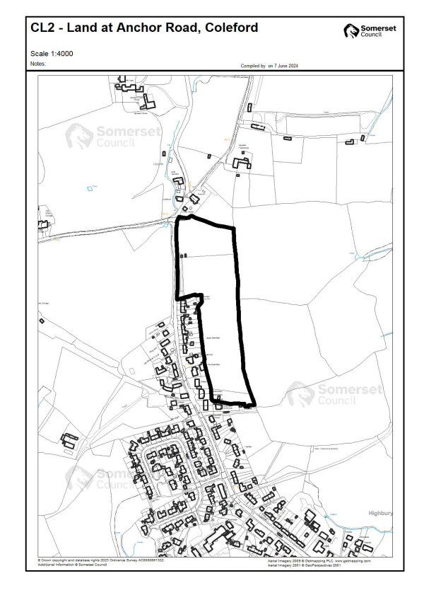
FR10: Land at North Parade Car Park, Frome (HELAA site FRO227)
Context
The site is currently a car park providing around 90 spaces in the centre of Frome but is underutilised. It is bordered by the railway line to the southwest and the B3090, North Parade, to the northwest. A college (North Hill House) lies to the northeast and the Millenium Green open space adjoins to the southeast. The site is owned by Somerset Council and provides an opportunity to deliver affordable housing in an accessible location.
Heritage
The site is within the Frome Conservation Area. North Hill House, which is Grade II listed, lies 14m to the northeast.
Townscape and Ecology
The site lies within the outer consultation zone (Band C) of the Mells Valley SAC. It is not considered optimal habitat in the HRA. Tree screening on the boundary of the site and listed trees in the grounds of North Hill House on the site are important to local distinctiveness and townscape and provide a gateway to the Millenium Green.
Flood Risk
The site is located within Flood Zone 1 and there is a low risk of surface water flooding.
Policy FR10: Land at North Parade Car Park, Frome
Development Requirements and Design Principles**
** Development proposals must be in accordance with the policies in the development plan provided by the adopted Mendip Local Plan Parts I and II, unless other material considerations indicate otherwise. Applicants should have regard to relevant supplementary guidance as appropriate and applications should comply with adopted validation requirements
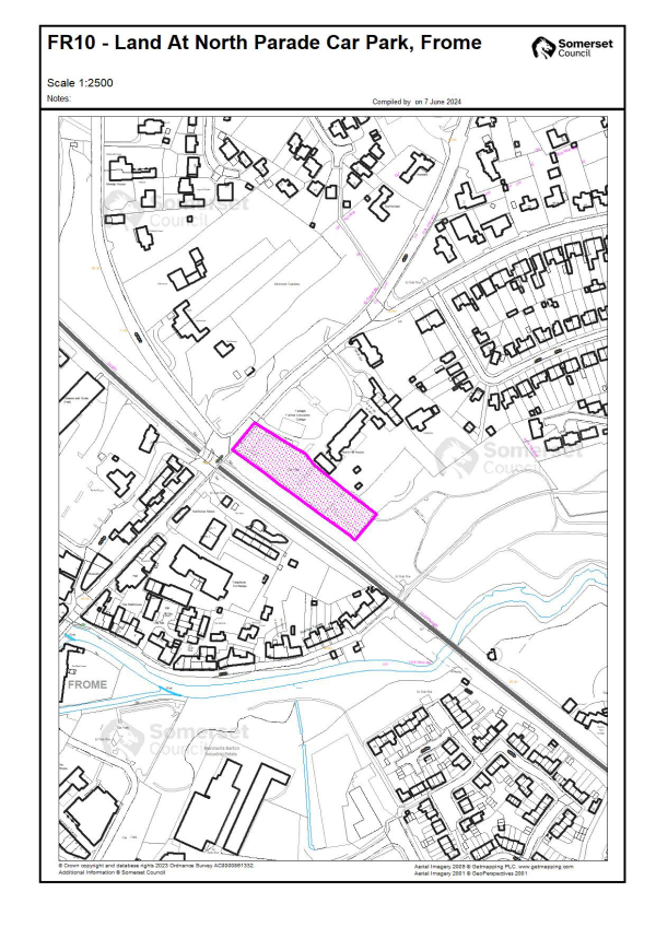
GL6: Land off Common Moor Drove (HELAA site GLAS124)
Context
Greenfield site on the built-up edge of Glastonbury comprising low lying pastureland west of the A39 (Glastonbury by-pass). Lowerside Lane has access onto the A39 and there is a pedestrian underpass near this junction. The Kingsfield housing development adjoins the site to the southeast, together with allotments and a rugby club to the northeast. The site is bounded by rhynes and Common Moor Drove to the northwest.
The site has an outline planning permission (2021/2466/OTS) for a maximum of 90 homes.
Landscape
The site is at the junction of two landscape types, defined by an “island” of high land rising out of the surrounding low-lying moorland. This is a distinctive characteristic of the Isle of Avalon landscape character area. The site also has intervisibility with St Michael’s Tower at the Tor and Wearyall Hill. Both the Tor and Wearyall Hill are designated Special Landscape Features, although both are at some distance from the site.
Ecology
The site includes areas of Priority Habitat (coastal and floodplain grazing marsh) and is within the impact risk zone for Street Heath and Sharpham Moor SSSIs. The ecological interest on the site is largely along boundary features.
The site falls within the risk area of the Somerset Levels and Moors RAMSAR (Brue catchment). Mitigation for surface and foul water will be required to demonstrate nutrient neutrality.
Flood Risk
The majority of the site is in Flood Zone 1. Some parts of the site are within Flood Zones 2 and 3. The land has a naturally high groundwater level.
Policy GL6: Land off Common Moor Drove, Glastonbury
Development Requirements and Design Principles**
** Development proposals must be in accordance with the policies in the development plan provided by the adopted Mendip Local Plan Parts I and II, unless other material considerations indicate otherwise. Applicants should have regard to relevant supplementary guidance as appropriate and applications should comply with adopted validation requirements
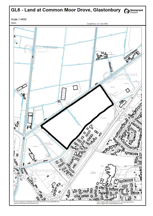
Context
Car park in central Glastonbury surrounded by residential development and with St John’s Infants School to the south. The car park has a central block of garages. It is underutilised and there are three public car parks in close proximity to the site. The area also provides an informal pick-up/drop off point for the school.
The site is owned by Somerset Council and provides an opportunity to deliver affordable housing in an accessible location.
Townscape & Ecology
The site is within the urban area and within a Species Alert Area for Pipistrelle Bats.
The site falls within the risk area of the Somerset Levels and Moors RAMSAR (Brue catchment). Mitigation of surface and foul water will be required to demonstrate nutrient
neutrality.Heritage
Glastonbury Conservation Area lies 50m to the south of the site. There are also a large number of listed buildings to the south of the site, particularly along the High Street which is 150m to the south. The nearest listed building is Hawkins House (Grade II) which is 80m to the south on Church Lane.
Flood Risk
The site is located within Flood Zone 1.
Policy GL7: Land at Norbins Road, Car Park
Development Requirements and Design Principles**
** Development proposals must be in accordance with the policies in the development plan provided by the adopted Mendip Local Plan Parts I and II, unless other material considerations indicate otherwise. Applicants should have regard to relevant supplementary guidance as appropriate and applications should comply with adopted validation requirements
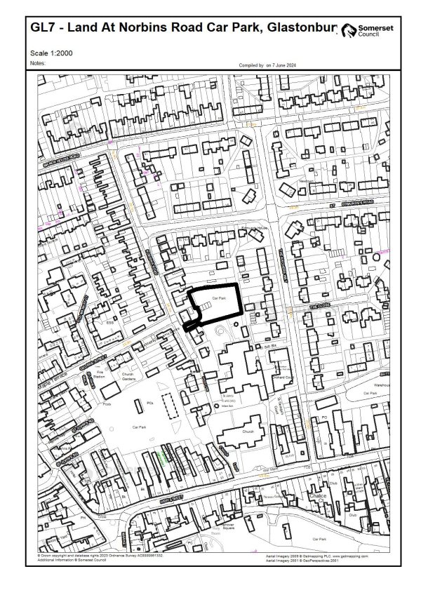
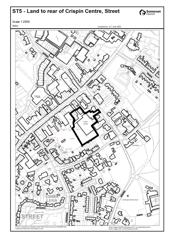
ST5: Land to rear of Crispin Centre (HELAA site STR146)
Context
This is a brownfield site within the designated town centre of Street. It adjoins the Street Conservation Area on the northwestern and southeastern boundaries. The site was previously in use as a shopping centre and supermarket but has been largely vacant for a number of years.
The site is a suitable location for housing for older people. It is close to the town centre and has easy access to a wide range of facilities.
It is within the Town Centre Area defined by Policy DP21, where character and function are orientated towards town centre activities.
Townscape & Ecology
The site is within the urban area and within a Species Alert Area for Noctule, Pipistrelle and Brown Long Eared Bats.
Heritage
There is a Grade II listed mural within the shopping centre. Crispin Hall (also Grade II listed) lies 5m from the northeastern boundary.
The site lies adjacent to the Street Conservation Area. The boundaries of the allocated site exclude frontage buildings on the High Street which fall within the Conservation Area.
Flood Risk
The site is located within Flood Zone 1 and is at very low risk of surface water flooding.
Policy ST5: Land to rear of Crispin Centre, Street
Development Requirements and Design Principles**
** Development proposals must be in accordance with the policies in the development plan provided by the adopted Mendip Local Plan Parts I and II, unless other material considerations indicate otherwise. Applicants should have regard to relevant supplementary guidance as appropriate and applications should comply with adopted validation requirements
Context
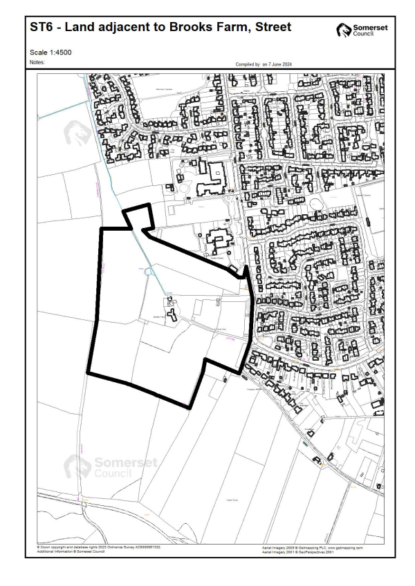
This 11ha site is located on the southwestern edge of Street. It includes Brooks Farmhouse and associated ancillary development. Brooks Road runs along part of the eastern boundary with extensive existing residential development lying to the east of the public highway. This site lies to the south of a strategic mixed-use site subject to Policy ST3 in Local Plan Part II. A Future Growth Area (FGA) identified in Policy ST3 adjoins the western boundary and covers approx. 5 Ha of the allocated site. The north of the site is directly adjacent to Avalon School and Brookside Academy.
The FGA was identified in LPP1 as land suitable for housing to build-in flexibility of supply and maintain delivery. Updated ecology studies for this area indicate it can deliver a greater quantum of housing than indicated in Policy ST3. This could be between 120 and 160 dwellings.
Policy ST3 requires masterplanning of the wider site, including the FGA, before development. Policy ST6 indicates this site can come forward independently provided key matters on an integrated approach are addressed.
Highways
The farm has existing and potential access points from Brooks Road and care should be taken to ensure that cumulative impacts are acceptable.
Landscape
The site is well related to the urban area, but regard should be had to the impact on Ivythorn Hill which is designated as a Special Landscape Feature. Mitigation will be required to soften the edge of development where it transitions to open countryside, and to protect views from Ivythorn Hill.
Ecology
The site is within a Species Alert Area for Noctule, Pipistrelle and Hazel Dormice and butterflies. Adopted Policy ST3 (6) indicates that surveys are required to establish presence of species, and proposals should ensure that populations of these species remain in a favourable condition. The site also includes areas of Nature Recovery Network sites for broad leaved woodland and ancient/veteran trees.
The site utilises wastewater treatment facilities that lie within a hydrological catchment flowing into the Somerset Levels and Moors Ramsar. Increased nutrients (phosphates) resulting from the development may result in degradation or changes in water quality. There is a potential likely significant effect on the Ramsar. Mitigation of this allocation through on-site measures or phosphate credits will be required to achieve nutrient neutrality.
Education
A new primary school is included in requirements for strategic site ST3, and contributions may be required for the provision of additional education capacity.
Flood Risk
The site is located within Flood Zone 1. There are several watercourses that flow across the site.
Policy ST6: Land at Brooks Farm, Street
Development Requirements and Design Principles**
** Development proposals must be in accordance with the policies in the development plan provided by the adopted Mendip Local Plan Parts I and II, unless other material considerations indicate otherwise. Applicants should have regard to relevant supplementary guidance as appropriate and applications should comply with adopted validation requirements
Context
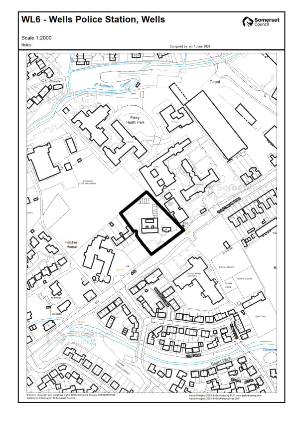
Brownfield site within the urban area of the city. The site was previously in use as a police station. It adjoins the Wells Health Centre and a children’s day nursery to the northeast. There is residential development and a care home to the southwest and school playing fields to the northwest. The site fronts Glastonbury Road and there is an existing access.
The site is a suitable location for housing for older people and is adjacent to an existing care home. It is accessible to a wide range of facilities.
The site has full planning permission for 47 self-contained retirement apartments (C3 use) (2020/2234/FUL).
Ecology
The site is within Band B of the North Somerset and Mendip Bat SAC and an Alert Area for several other species. The HRA notes this site does not provide optimal foraging or commuting habitat for Greater or Lesser Horseshoe Bats.
Townscape & Heritage
The site is within the urban area, with the Grade II listed Priory Hospital being 30m to the east. The Gatehouse (Grade II listed) is also 90m to the southwest.
Flood Risk
The site is located in Flood Zone 1 with a very low risk of surface water flooding. However, there is an area of Flood Zone 2 and 3 at the highway entrance.
Policy WL6: Wells Police Station, Glastonbury Road
Development Requirements and Design Principles**
** Development proposals must be in accordance with the policies in the development plan provided by the adopted Mendip Local Plan Parts I and II, unless other material considerations indicate otherwise. Applicants should have regard to relevant supplementary guidance as appropriate and applications should comply with adopted validation requirements
Context
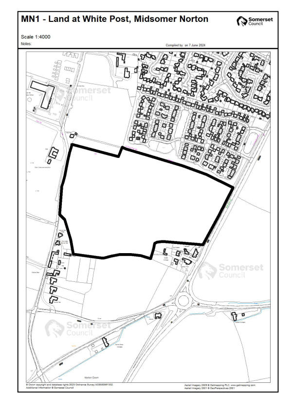
A 12.8ha field in open countryside on the edge of Midsomer Norton/Westfield. The A367 Fosseway is to the east and the B3355 Silver Street to the west. There is some limited development to the south of the site including Norton Hall Farm on Silver Street and the White Post Inn on Fosseway. There is residential development to the north which falls in the Bath and NE Somerset LPA.
The site has outline and reserved matters planning permission for 270 units (2021/1480/OTS and 2023/1858/REM).
Landscape & Ecology
The site lies on the edge of the built-up area of Midsomer Norton and Westfield. Development will have a degree of impact upon local landscape character and long-distance views. There is a well-established hedge line with mature trees on the northern and eastern boundaries. The site lies outside the Bat SAC consultation area.
Heritage
This site does not lie within a conservation area and is not in close proximity to designated heritage assets. Archaeological features may be present on the site.
Cross-boundary Infrastructure
The site lies on the southern boundary with Bath and NE Somerset (BaNES). Highways and infrastructure impacts in BaNES will need to be taken into account.
Joint working will be required between BaNES, Somerset Council and education authorities to accommodate the pupil numbers arising from the development.
Flood Risk
The site lies within Flood Zone 1. There is a limited area of surface water flooding (low risk) on the northeastern boundary.
Policy MN1: Land at White Post, Midsomer Norton
Development Requirements and Design Principles**
** Development proposals must be in accordance with the policies in the development plan provided by the adopted Mendip Local Plan Parts I and II, unless other material considerations indicate otherwise. Applicants should have regard to relevant supplementary guidance as appropriate and applications should comply with adopted validation requirements.
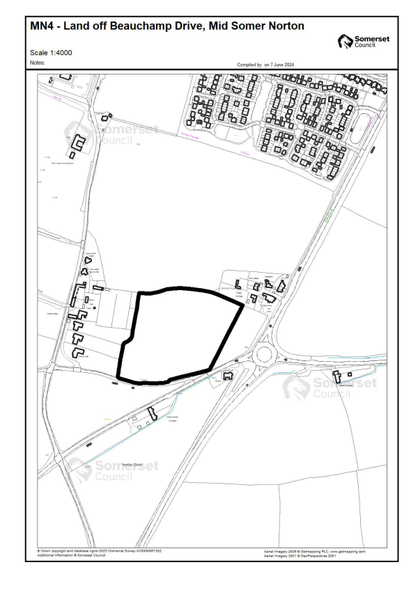
Context
Greenfield site sloping towards Beauchamps Drive. Located immediately south of the Policy MN1 site. The White Post Inn lies to the northeast and Norton Down Methodist Church to the south. There are 3 dwellings to the west, currently in open countryside. These occupy the site of the former Norton Hall, and the site retains a parkland character.
The site has planning permission for up to 75 dwellings (2021/0157/OTS and 2022/2207/REM).
Landscape & Ecology
The site is prominent in the local landscape and development could have an urbanising effect. Mitigation will be required to soften the edge of development where it transitions to open countryside.
The site is in a Species Alert Area for Pipistrelle and Brown Long Eared Bats.
Heritage
Norton Down Methodist Church is Grade II listed and lies 30m to the southeast of the site. There is historic estate railing to the north of the site associated with the former Norton Hall.
Infrastructure Capacity
Contributions may be required to provide additional education and health provision. Joint assessment and agreement between BaNES and Somerset Council of infrastructure impacts will be required. Mitigation measures and/or financial contributions will be secured via S106.
Highways
The site is accessed from Beauchamps Drive which links to B3355 Silver Street and the A367 roundabout. Particular regard should be given to access by walking and cycling, as well as connectivity to site MN1 to the north and local facilities.
A cross-boundary transport impact assessment (agreed with both Somerset Council and BaNES) and travel plan for the development will be required. This should consider the cumulative impacts on the highway network (including on the availability of town centre parking) of committed and allocated development in Midsomer Norton. Mitigation proposals should be targeted to reduce car usage, including local walking and cycling improvements and measures to improve the attractiveness and connectivity of bus services.
A transport impact assessment will need to determine the need for, and form of, highway capacity measures to mitigate the impact of the proposed development.
Proportionate contributions will be sought towards mitigation necessary to address severe traffic impacts.
Flood Risk
The site lies within Flood Zone 1. There is a limited area of surface water flooding (low risk) on the northeastern boundary.
Policy MN4: Land at Beauchamps Drive
Development Requirements and Design Principles**
** Development proposals must be in accordance with the policies in the development plan provided by the adopted Mendip Local Plan Parts I and II, unless other material considerations indicate otherwise. Applicants should have regard to relevant supplementary guidance as appropriate and applications should comply with adopted validation requirements
Context
A single field alongside Anchor Road adjacent to the development limit for Coleford. There is residential development to the southwest and southeast. The site extends the built-up area between the northern end of Coleford and the hamlet of Lipyeate.
The site has outline planning permission for up to 63 dwellings (2019/2345/OTS).
Landscape & Ecology
The site is on a ridge of high ground, although long views are limited by the landform. The site extends towards the hamlet of Lipyeate. The site is within Band C of the Mells Valley Bat SAC. Surveys have shown that the site is used by Greater Horseshoe Bats for commuting and foraging. Alternative habitat will therefore be required.
Heritage
Rush Ash Farmhouse (Grade II listed) lies 5m to the south of the site.
Flood Risk
The site is located within Flood Zone 1 and there is a low risk of surface water flooding.
Education Capacity
A contribution to provide capacity in local schools may be required.
Policy CL2: Anchor Road, Coleford
Development Requirements and Design Principles**
** Development proposals must be in accordance with the policies in the development plan provided by the adopted Mendip Local Plan Parts I and II, unless other material considerations indicate otherwise. Applicants should have regard to relevant supplementary guidance as appropriate and applications should comply with adopted validation requirements
