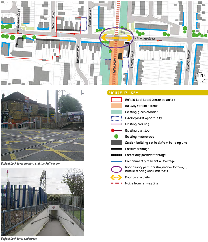
17.1.1 Enfield Lock Station is located on Ordnance Road, which connects Hertford Road to the west and Mollison Avenue to the east. It is therefore an important route for vehicular traffic, pedestrians and cyclists. Although named Enfield Lock, the station does not physically relate to the Lock itself being some 15-20 minutes’ walk from the heart of the Enfield Lock Conservation Area.
17.1.2 Ordnance Road crosses the railway line at a level crossing. This is currently closed for approximately 40 minutes out of every hour, and traffic is therefore frequently disrupted. There is a short underpass on the northern side of Ordnance Road - this is very narrow, and so cannot easily be shared by pedestrians and cyclists. There are small fenced off areas next to the underpass that appear to be operational railway land. These create a cluttered and unattractive street scene.
17.1.3 The station building is set well back from Ordnance Road - as a result, the station itself is not visually obvious until very close to the level crossing. The Railway Inn pub is a useful landmark.
17.1.4 The Ordnance Road local centre is located to the west of the station, and is somewhat detached from the immediate station area as residential properties lie between the retail area and the station itself.
17.1.5 The proposed West Anglia Mainline Enhancements project would result in the closure of the level crossing to all traffic, and so change the area very significantly in the future. Pedestrian and cycle connections will need to be improved.
17.1.6 There is an opportunity to create a stronger identity around the station area. Visually connecting the local centre to the station through public realm improvements would help to ‘tie’ the two together. The junction with Tysoe Avenue / Newbury Avenue has the potential to create a ‘gateway from the east, particularly by improving the green space on the north-western side of the junction.
17.1.7 The policies consider both the short-term future of Enfield Lock Station with the level crossing remaining operational, and the longer-term future with the closure of the level crossing as a result of West Anglia Mainline Enhancements.

Policy Context for Chapter 17: Enfield Lock Station Area |
|
London Plan |
Policy 6.2: Providing public transport capacity and safeguarding land for transport Policy 6.9 Cycling Policy 6.10 Walking Policy 7.4 Local Character Policy 7.4 Public Realm |
Upper Lee Valley Opportunity Area Planning Framework |
Objective 7 |
Core Strategy (Adopted Nov 2010) |
Policy 17: Town Centres Policy 18: Delivering shopping provision Policy 30: Maintaining and improving the quality of the built environment Policy 40: North East Enfield |
Adopted Development Management Document |
Policy DMD37: Achieving high quality and design-led development Policy DMD28: Large local centres, small local centres and local parades |
Other Sources |
National Planning Policy Framework National Planning Policy Guidance Town Centre Uses and Boundaries Review, 2013 Cycle Routes in Enfield, Oct 2013 |
Figure 17.1: Enfield Lock Station Area- Key Issues

Figure 17.2: Enfield Lock Station Area- Policy Principles: Short Term

Project Ref |
Description |
17.1a |
Low key public realm improvements, with three |
17.1b |
Improve existing underpass |
17.1c |
Encourage redevelopment of land to the rear |
Policy 17.1: Enfield Lock Station area - short term The Council will develop a comprehensive street design scheme which - through public realm enhancements - helps to enhance local distinctiveness, support Local Centre activity and contribute to an improved sense of security whilst still providing for traffic movements. This scheme should include:
The Council will encourage redevelopment of land to the rear of the Railway Inn for residential or mixed-use development, so creating a higher quality approach to the station along Bradley Road. The Council will encourage redevelopment of the site to the west of the railway line to create a positive frontage onto Ordnance Road that helps signal the station. |
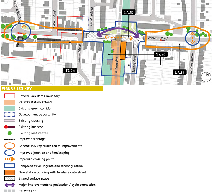
Figure 17.3: Enfield Lock Station Area- Policy Principles: Long Term

Policy 17.2: Enfield Lock Station area - long term The closure of the level crossing as a result of West Anglia Mainline Enhancements will change the character of Ordnance Road. The increased frequency of trains will make the area more attractive to residents who wish to commute out of the area. The station’s importance as a key destination will therefore increase. This policy sets out principles broadly similar to Policy 17.1, but provides a greater focus on improving the station area itself. The Council will produce a Planning Brief incorporating these principles. The Council will develop a comprehensive street design scheme which - through public realm enhancements - helps to enhance local distinctiveness, support Local Centre activity and contribute to an improved sense of security whilst still providing for traffic movements. This scheme should include:
Encourage redevelopment of the site to the west of the railway line to create a positive frontage onto Ordnance Road that helps signal the station. |
Project Ref |
Description |
17.2a |
Low key public realm improvements, with three |
17.2b |
Major improvements to station area including: a new station building, new pedestrian-friendly shared surface areas, new pedestrian/cycle crossing of the railway. |
17.2c |
Encourage redevelopment of land to the rear |
< Previous | ^ Top | Next >