
Fig 10. Enfield Characterisation Study
© Crown Copyright and database right 2012. Ordnance Survey Licence no. 100019820
This section provides an overview of the environmental context of the NCAAP area. The range of different forms of development across the area is explored and a view taken on the relationships between these areas and what this might mean for future development in the NCAAP area.
The Borough-wide 2011 Enfield Characterisation Study was prepared soon after the adoption of the Core Strategy. The study provides a description of the physical form of the borough, its origins, landscapes, places, streets and buildings to provide an understanding of the particular attributes.
The Study reveals the suburban residential character of much of the AAP area – character dominated by ‘classic suburban’ typically interwar housing areas concentrated on the northern side of the A406 with older ‘urban terraced’ housing stock south of the A406. The New Southgate area is far more varied with a number of discrete housing estates arranged around established Victorian terraced streets.
By mapping the key nodes of community activity and broad character area boundaries within the NCAAP area, three distinct character areas emerge. The character areas identified here are as much about natural walkable catchments as they are about architectural detailing.
As the borough-wide Characterisation Study identifies, the New Southgate area has no prevailing character types and is therefore different from the suburban streets surrounding it. The area’s fractured smaller elements are generally contained between the railway line to the west and the Underground line to the east. Arnos Grove commercially anchors the area, supported by local parades to the west along Bowes Road and Friern Barnet Road.
A central walkable catchment area is defined by the Underground line to the west and the London to Stevenage railway line to the west. Townscape character varies between the area on the north side of the A406 and the area on the south, but both are characterised by well defined and homogenous housing areas. They are connected by the commercial and community uses clustered around the Ritz Parade.
East of the Stevenage railway line, the NCAAP area is focussed around the commercial spine of Green Lanes with a regular pattern of residential street on the south side of the North Circular Road. The character is more mixed on the north side on the approach to Palmers Green, but Green Lanes remains the principal axis.
These three urban areas – the Arnos Grove/ New Southgate area; the Bowes Road area; and the Green Lanes area – define three walking catchments within the AAP area. Whilst it is clear the commercial centres of the NCAAP area serve catchments which extend beyond these areas and local people within each of these areas will frequently travel beyond the centres identified for their retail, employment and community service requirements, these three different zones – or neighbourhood areas – do emerge.
More detailed planning and design guidance on these areas is outlined in Section 4 below.
Key nodes / Pointd of transition
As one moves between these character areas, there are points of transition where characters change. These thresholds have the potential to aid legibility and provide an opportunity for the local townscape to respond positively to this opportunity. Working west to east key points include the following:
Fig 11. NCAAP Strategic Context Plan
© Crown Copyright and database right 2012. Ordnance Survey Licence no. 100019820
NC POUCY 11 THREE NEIGHBOURHOOD PLACES
Within the North Circular AAP there are three 'neighbourhood places', each serving their respective local communities. The three neighbourhood places and the key priorities for them are as follows:
The NCAAP is served by a number of designated commercial centres. These locations, which tend to be well served by public transport services, act as a focus of community activity and provide important day to day retail and community service requirements for local people.
The patterns of movement and retail behaviour of local residents is highly complex, being influenced heavily by the attraction of larger surrounding retail centres of Palmers Green, Wood Green, Brent Cross and Central London beyond. Notwithstanding this, smaller centres and local parades continue to play an important role in establishing sustainable neighbourhoods. A detailed review of existing centres across the Borough was undertaken to inform the DMD and the importance of large local centres, small local centres and local parades is recognised under DMD 28 which itself supports Core Policy 17 Town Centres.
The main centres within the AAP are as follows:
These centres are broadly equidistant from each other, being no more than 1km (10-15mins walk) apart, and are within walking distance of the vast majority of local residential communities within the whole AAP area. In line with Core Strategy and DMD policies, the NCR will seek to protect and support these centres and parades where they continue to perform an important and viable role in meeting the everyday shopping and community needs of the local population.
In response to these small-scale commercial locations within the AAP area, three ‘neighbourhood places’ have been identified in consultation with local residents. Whilst these are not major retail locations, they do contribute positively to the character and richness of the area. The focus for change in the North Circular AAP area will be the three neighbourhood places of Arnos Grove/New Southgate, Bowes Road and Green Lanes. These three places represent the commercial and community centres for the surrounding residential neighbourhoods and as such are where new development and environmental enhancements will be of greatest value. It is intended that focusing on these three areas will enable stronger north-south connections to be facilitated across the North Circular route.
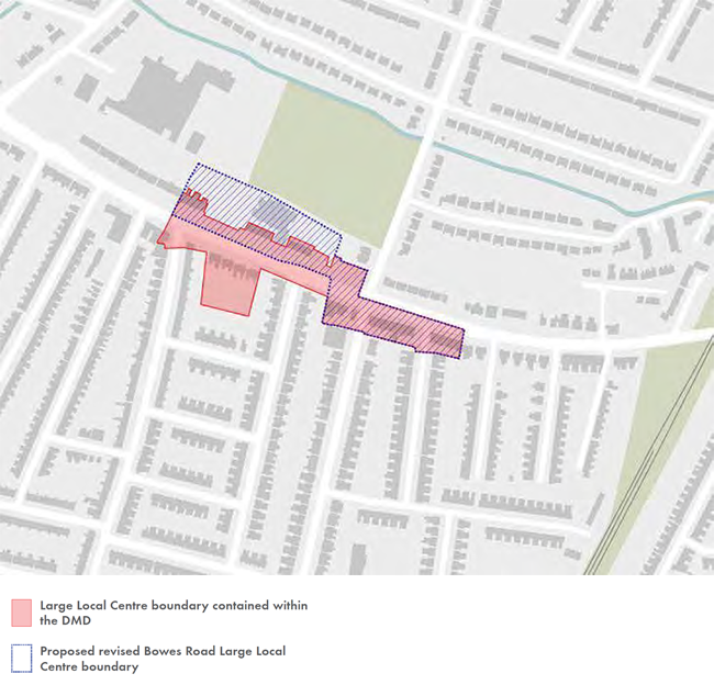
Fig 12. Revised Bowes Road Large Local Centre
© Crown Copyright and database right 2012. Ordnance Survey Licence no. 100019820
The approach adopted for each ‘neighbourhood place’ is as follows:
Arnos Grove/New Southgate: Identified as a Regeneration Priority Area, New Southgate and Arnos Grove benefit from a masterplan which has been adopted as a Supplementary Planning Document. This masterplan will direct changes in this area delivering new employment, housing and community development. Developers have been appointed to deliver the redevelopment of the Ladderswood Estate which will spearhead the changes in New Southgate and deliver the objectives of the New Southgate Masterplan.
Bowes Road: Centred on the existing commercial Ritz Parade and the parade at the junction between Brownlow Road and Bowes Road, this central area of the AAP acts as a community hub with retail uses either side of the main road and a primary and secondary school serving the local community. There is an opportunity for new mixed use development within the revised boundary of the Bowes Road Large Local Centre which can consolidate and strengthen the commercial and community uses within the Ritz Parade.
Green Lanes: The junction between Green Lanes and North Circular Road will be a major focus for change with a number of development sites supporting the wider regeneration of the area. Whilst the existing commercial parades on the south side of the main junction remain intact and address the corner successfully, the parade on the north side of the junction is less successful. There may, therefore, be opportunities to improve this prominent location, particularly on the northern side.
In addition to boundary changes made via the DMD, it is suggested that further changes to the Bowes Road Large Local Centre are considered to exclude residential properties opposite Ritz Parade and include the former Esso Garage site and adjacent car wash site. The changes are intended to provide the scope to create a more viable commercial parade that can offer a better community and local shopping function with improved parking and access arrangements. The suggested revised boundary for the Bowes Road Large Local Centre is set out in Fig 12.
Addressing each identified neighbourhood place in turn, the following sections present an urban analysis of each of the three neighbourhood places within the area. This analysis will inform directly the policies and proposals in the NCAAP. The analysis is presented in the following sections:
Core Policies 44 and 45 are directly relevant here. The guidance contained within these principles respond directly to the analysis presented in the Environmental Context section above. Further more detailed guidance, principles and background is contained within the New Southgate Masterplan.
Fig 13. Arnos Grove/New Southgate - opportunity sites
© Crown Copyright and database right 2012. Ordnance Survey Licence no. 100019820

Local environments across the Arnos Grove / New Southgate neighbourhood place

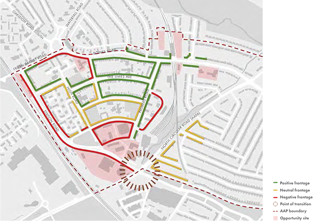
Fig 14. Arnos Grove/New Southgate - townscape
© Crown Copyright and database right 2012. Ordnance Survey Licence no. 100019820
Arnos Grove and New Southgate
This incorporates the western section of the NCAAP area and is situated between Arnos Grove and New Southgate stations with the railway lines forming the boundary edges. The area is radially planned around local facilities and appears to be a legacy of an early twentieth-century self-contained neighbourhood development. The focal points within the area include Garfield Primary School and the associated green spaces, and Our Lady of Lourdes RC Primary School on The Limes Avenue.
The following section provides an overview of some of the key environmental and public realm issues and opportunities associated with this neighbourhood place. The analysis has directly informed the preparation of the policies relating to this neighbourhood place and therefore forms an important part of the context within which development proposals will be considered.
Opportunity sites (Fig 13)
Development sites within the Arnos Grove/New Southgate neighbourhood area are identified in Fig 13.
The sites were identified in the New Southgate Masterplan which was adopted in December 2010 by Enfield Council following significant public and stakeholder consultation. The main focus of the masterplan was the emergence of a regeneration strategy for the Ladderswood Estate (1). The vision for this area also included the redevelopment of the Western Gateway area (2, 3 & 4) including the gasholder site which commands a prominent position on the A406 corridor. Additional sites identified include the land around New Southgate Station (5), the site of the existing Coppicewood Lodge Care Home on Grove Road (6), the two TfL owned car park sites either side of Arnos Grove station, a small site opposite the station (all 7) and the Arnos Pool, Bowes Road Library Arnos Grove Health Centre site (8).
Townscaape (Fig 14)
The Arnos Grove area benefits generally from good quality townscape with clearly defined streets which are overlooked by development which creates strong street frontages. Garfield School situated in the centre of the area occupies an entire block but the boundary treatment allows views across the site. In the New Southgate and Ladderswood Estate areas to the south and west of the area along Station Road, townscape quality is much poorer with streets generally being ill defined and not being addressed by buildings. There is a lack of distinction between public and private space in these areas. With the known development sites being clustered in this area, this is something that new development can help address.
This is a diverse area in terms of built character, with a number of post war housing estates sitting alongside more traditional Victorian and Edwardian terraced streets. Building heights also vary between the traditional streets and the housing estates. The prevailing building heights in Arnos Grove are typically between 2 and 4 storeys along Bowes Road. Within the core of the area in the housing streets such as The Limes Avenue and Springfield Road, dwellings are typically two or three storeys in height. The housing within the Red Brick Estate opposite New Southgate station, with ground floors dominated by garage doors, are uniformly three storeys. The point block typology of the Highview and Ladderswood estates are quite different in character with towers in both rising to 13 storeys.
The A406 junction with Station Road and Bounds Green Road is a key node and acts as one of the principal gateways to Enfield Borough. The gas holder on the north west side of this junction acts as a landmark which helps hold this key junction. The built edges of the other corners of this junction fail to provide activity or enclosure.
Fig 15. Arnos Grove/New Southgate - activities
© Crown Copyright and database right 2012. Ordnance Survey Licence no. 100019820

Activities (Fig 15)
The area is mixed but predominantly residential in character with Arnos Grove being the principal commercial centre serving local people. There are other smaller local parades at the Bowes Road/Waterfall Road roundabout and on Friern Barnet Road near New Southgate Station. The Friern Barnet Retail Park is accessed directly off the A406 west of the railway line.
With two primary schools, a library and leisure pool and a number of churches and associated church halls, the area benefits from a range of community facilities all within close walking distance of local residents.
The New Southgate Industrial Estate is allocated as a Locally Significant Industrial Site under Core Policy 15. The allocation has however been rationalised in order to facilitate delivery of the regeneration priorities through the regeneration of the Ladderswood Estate and surrounding land. The Enfield Employment Land Study 2012 identifies that the remaining land is probably too small and lacks profile to have a long term future in employment use. However the study does recommend that, if implemented, the offices proposed as part of the New Southgate Masterplan be brought back within the LSIS designation to strengthen this employment allocation.
Public Realm and open space (Fig 16)
Aside from the structural open spaces of Arnos Park (A) and Broomfield Park that lie immediately to the north of the AAP area (designated as Metropolitan Open Land and therefore given similar protection against development as green belt), the principal open spaces in this area are roadside spaces on the north side of the A406 along the Pymmes Brook, Bounds Green Brook (C) and either side of Bounds Green Road (D). New Southgate is well served with local open spaces with Grove Road open space opposite St Paul’s church (H), High Road open space (F) adjacent to Garfield School and Millennium Green (G) on Station Road. Improvements to these spaces are being delivered through the ‘Shaping New Southgate’ initiative now that the New Southgate Masterplan has been adopted. Most recently under this initiative, the ‘Take the High Road’ project outlines a range of improvements to the High Road axis which links Grove Road open space at its northern end with High Road open space and Millennium Green to the south.
Movement and connections (Fig 17)
This is the most accessible part of the NCAAP area by public transport, with good links to the rail network via New Southgate Station and the underground network via Arnos Grove Station. A network of bus routes traverse the area with stops along the area’s main roads. These services provide good connections across north London as follows:
34 from Barnet High Street / Barnet Church to Walthamstow Bus Station
184 from Turnpike Lane Bus Station to Barnet
221 from Edgware Bus Station to Turnpike Lane Station
232 from Stonebridge to Turnpike Lane Station
251 from Arnos Grove Station to Edgware Station
298 from Arnos Grove Station to Potters Bar
382 from Southgate Station to Mill Hill East Station
N91 from Cockfosters Station to Whitehall / Trafalgar Square
NC POLICY 12 ARNOS GROVE / NEW SOUTHGATE NEIGHBOURHOOD PLACE
Key principles that will guide change in the New Southgate/Arnos Grove neighbourhood place are as follows:
Fig 16. Arnos Grove/New Southgate - open space
© Crown Copyright and database right 2012. Ordnance Survey Licence no. 100019820

Fig 17. Arnos Grove/New Southgate - movement and connections
© Crown Copyright and database right 2012. Ordnance Survey Licence no. 100019820

Fig 18. NCAAP Site Proposals
© Crown Copyright and database right 2012. Ordnance Survey Licence no. 100019820

This policy should be read in conjunction with site specific policies for key development sites within the Amos Grove/New Southgate neighbourhood place.
The New Southgate area is identified as a Regeneration Priority Area. In recognition of this, the Council has recently prepared and adopted the New Southgate Masterplan. The masterplan provides a detailed framework for the regeneration of this important part of the Borough. Central to the vision outlined in the masterplan is the regeneration of the Ladderswood Estate. The Council is working with its strategic partners Mulalley and One Housing Group in the delivery of this regeneration.
NC POLICY 13 LADDERSWOOD ESTATE (SITE 1)
Redevelopment of the estate will provide a new high quality housing environment with new buildings directly addressing key existing streets in the area. Taking full account of the guidance contained within the New Southgate Masterplan, new development should take account of the following:
The redevelopment of the Ladderswood Estate is the centrepiece of the Council’s proposals for the New Southgate Regeneration Priority Area. In February 2014 the Council granted planning consent for a mixed used residential led scheme that includes six B1(b)/B1(c) commercial units that will provide high quality, flexible employment premises offering new work spaces for start-up and other small businesses. The consented scheme also includes employment development in the form of a hotel. Having prepared the New Southgate Masterplan in consultation with local residents, the Council and its housing and development partners will continue to work in partnership with the local community to deliver the phased redevelopment of the estate and with it a programme of public realm and other improvements. This includes delivering a coordinated programme of improvements to open spaces in the area under the ‘Take the High Road’ initiative.
NC POLICY 14 WESTERN GATEWAY (SITES NUMBER 2, 3 AND 4)
Redevelopment of the retail warehousing and gasholder site provides a major opportunity to deliver a landmark development at this key gateway to the Borough. Taking full account of the guidance contained within the New Southgate Masterplan, new development should take account of the following:
The key gateway location has a important role in establishing the first impressions of the Borough. There is an opportunity to create a high quality, high density, mixed use scheme which responds positively to the site’s prominent location. The site is currently divorced from its surrounds by the heavily engineered nature of Station Road. By giving more priority to pedestrians and reconnecting the area with Arnos Green via Palmer’s Road, the mixed use redevelopment of this large site has the potential to deliver a new and fully integrated neighbourhood for New Southgate.
NC POLICY 15 NEW SOUTHGATE STATION AREA (SITE 5)
The site presents potential for mixed use development with commercial uses on lower floors and apartments above. Taking full account of the guidance contained within the New Southgate Masterplan, new development should take account of the following:
New Southgate Station currently has a poor relationship with its hinterland and redevelopment of the sites around the station has the potential to address this directly. New Southgate station is already an important transport hub for the local community providing frequent train services to central London. There is an opportunity to improve the relationship between the station area and the local commercial parade along Friern Barnet Road which would strengthen the commercial viability of the area as a whole.
NC POLICY 16 COPPICEWOOD LODGE CARE HOME SITE (SITE 6)
The site presents potential for mixed use development across a number of buildings. Taking full account of the guidance contained in the New Southgate Masterplan, new development should take account of the following:
Fig 19. Bowes Road - oppurtunity sites
© Crown Copyright and database right 2012. Ordnance Survey Licence no. 100019820

The New Southgate Masterplan confirms that the existing care home facility on the site is not fit for purpose and does not meet the standards of a modern care home and the site would become available if alternative accommodation is made available. Should the site come forward it is considered suitable for a range of community uses. In particular, the site is considered appropriate for a new health facility should the accommodation be required.
NC POLICY 17 ARNOS GROVE STATION (SITE 7)
The site presents potential, subject to further discussions with TfL, for land currently used for surface parking to be released for redevelopment. Any new development would need to respect the setting of the Grade II listed station building. Taking full account of the guidance contained within the New Southgate Masterplan, new development should take account of the following:
If redevelopment would result in a reduction in the provision of public parking at this key interchange a clear justification for this loss would be required. That said, it is noted that a reduction in car parking would align with the policy direction of the Mayor’s London Plan and Transport Plan in terms of encouraging travel by sustainable modes of transport.
In conjunction with TfL further more detailed feasibility work is required to explore the development potential of this side. It is understood that TfL is reviewing its portfolio of car parks across London as part of a wider strategy to identify opportunities of releasing land for development whilst also consolidating car parking. This has resulted in developing a wider strategy which considers sites across a number of Boroughs. Therefore whilst in planning terms the Council would support the sites coming forward, consolidating car parking may not necessarily be the appropriate solution in the context of TfL’s wider study.
NC POLICY 18 ARNOS POOL BOWES ROAD LIBRARY AND ARNOS GROVE MEDICAL CENTRE (SITE 8)
The community and health facilities on this site will be protected and. If possible. extended. There is flexibility in the type of community facilities making use of the buildings. but the council will resist any loss of community uses where they are not replaced with alternative community uses Some limited near development for community uses may be appropriate.

Local environments across the Bowes Road neighbourhood place
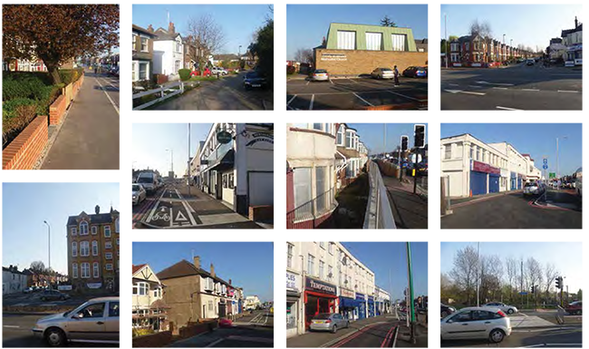
Fig 20. Bowes Road - townscape
© Crown Copyright and database right 2012. Ordnance Survey Licence no. 100019820

Any new development would be required to protect and enhance the existing Grade II listed buildings, and should take account of the following:
The community and health facilities on this site are important local community assets and should be retained. There is an opportunity to extend the medical centre to provide a modernised medical facility with capacity for up to 750sqm of accommodation, which would combine three local GP practices and, thus, meet changing needs.
Bowes Road Library, Arnos Pool and Bowes Road Clinic are Grade II listed buildings. As such, the Council will have special regard to the desirability of preserving the building, its setting and those features which make it special. Subject to the quality of the design, there is an area to the north of the existing medical centre that would be suitable for development. Any new building should help to improve the quality and range of community facilities in this location. The open space and landscape features of the site form an important part of the setting of the building.
This incorporates the central section of the NCAAP area and is situated between Telford Road to the west and the railway line west of the Green Lanes to the east. The area is characterised by close-knit Edwardian residential streets feeding off the south side of the A406 with larger more recent, interwar semi-detached and detached housing on the north side on the main road. The focal point of the area is the Bowes Road Large Local Centre and the nearby secondary and primary schools. The local centre incorporate the Ritz Parade on the north side of the A406 and the commercial parade either side of Hardwicke Road on the south side of the A406.
The following section provides an overview of some of the key environmental and public realm issues and opportunities associated with this neighbourhood place. The analysis has directly informed the preparation of the policies relating to this neighbourhood place and therefore forms an important part of the context within which development proposals will be considered.
Opportunity sites (Fig 19)
The development sites in this area are identified principally as a result of the lifting of the uncertainty associated with the future improvements along the North Circular Road. With the majority of the land identified now owned by Notting Hill Housing Trust, where it proved uneconomical to bring vacant or derelict dwellings back into use, alternative development options are being considered. A collection of small sites along Telford Road (9) have already been cleared and present housing opportunities. The corner site at the junction between Telford Road and Bowes Road (10) presents a prominent opportunity at this key node along the road corridor. The housing area on the north side of Bowes Road and adjoining the southern boundary of Broomfield Secondary School (11) presents opportunities to strengthen this prominent corner and introduce new housing on the boundary with the school itself.
The recent improvements to the A406 had a significant impact on The Ritz Parade (site 12). Some of the parade required demolition and some of the parking for the centre was lost. The road improvements have resulted in an awkward relationship between the road and the housing east of Powys Road. Some of this land has already been cleared and this has resulted a large redevelopment opportunity.
East of Powys Road (13), this large site presents a major opportunity for new residential development.
Fig 21. Bowes Road - open space
© Crown Copyright and database right 2012. Ordnance Survey Licence no. 100019820

Fig 22. Bowes Road - activities
© Crown Copyright and database right 2012. Ordnance Survey Licence no. 100019820

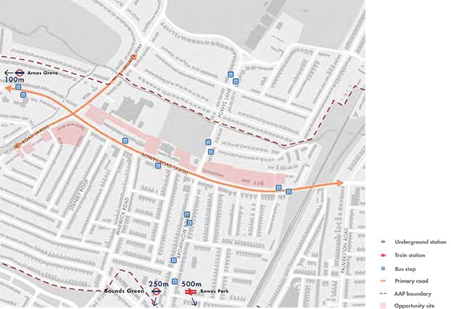
Fig 23. Bowes Road - movement and connections
© Crown Copyright and database right 2012. Ordnance Survey Licence no. 100019820
Townscape (Fig 20)
The area around the development sites is characterised by clearly defined urban blocks which generally help to define good street environments. The properties addressing the A406 directly, given the lack of investment that has occurred in the past, tend to be less well maintained and of more modest townscape quality.
Area 2b, (Fig 11) is adjacent to Arnos Grove Station, has characteristics comparable to the established residential areas east of the Telford Road/Wilmer Way axis with a predominance of 2 storey semi-detached inter-war and post-war family housing typically of the areas between Broomfield Secondary School and Broomfield Park (now outside the AAP boundary). The urban grain shifts from east-west to north-south across Area 2c south of the A406 with compact streets of smaller Victorian and Edwardian terraced 2 storey housing.
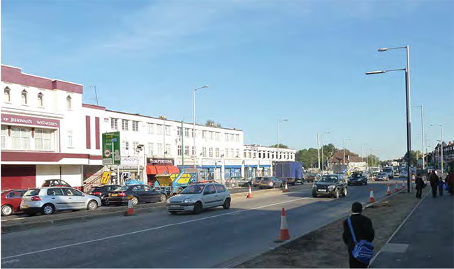
The break in the road at the junction between Telford Road and Bowes Road is a node on this prominent route. It marks a point of transition to a more street-based urban environment with both sides of the road presenting built and active edges to the street east of the junction. The Ritz Parade provides a point of local orientation along the road corridor. It is a distinctive building typical of the 1930s rising to three storeys at its centre. The central prominent bay which provides access to the large assembly hall to the rear is flanked by three storey wings falling to two storeys on either side. The former Esso Garage site west of the Ritz Parade has been cleared for some time and presents a break in the commercial frontage.
Generally the quality of the built frontage is of a higher quality on the south side of the main road. This correlates with the larger development opportunity sites which are predominantly stretched out along the northern side of the road.
Public realm and open space (Fig 21)
The area’s water courses and associated open spaces (C) provide the main recreational opportunities for open space amenities for local people. Opportunities to improve both Pymmes Brook (a natural river channel) and the New River (an artificial channel) will be sought. The New River in particular has good public access and presents some real opportunities where the quality of both the local environment and public access can be improved as identified by (D).
Activities (Fig 22)
Broomfield Secondary School (A), with approximately 1,350 pupils, has a catchment covering the majority of the NCAAP area. Bowes Primary School (B) currently has a school roll of approximately 500 and admits two forms of entry. Garfield School has a school roll of approximately 380 and admits two forms of entry. In 2013 the Council agreed permanent expansion plans taking the primary school to three forms of entry, construction of the new school is due to begin in autumn 2014.
The Bounds Green Recreation Centre (D) is a tennis and bowls club and a valuable community facility with hall hire and catering facilities.
A number of local centres and parades provide a valuable resource for local people. The viability of the Ritz Parade (E) has been further challenged by the recent TfL Safety and Environment Scheme which resulted in the loss of parking spaces and demolition of some of the commercial parade. The commercial parade on the south side of the A406 in this location (F) continues to service the day to day retail and community needs of the local Brownlow Road community. Both of these centres together form a designated Large Local Centre.
Movement and connections (Fig 23)
The A406 provides excellent strategic links eastwest and across north London. Arnos Grove and Bounds Green underground station (Piccadilly Line) are within walking distance, as is Bowes Park railway station providing links to and from central London. A range of bus services are from stops along the A406 and Powys Lane/Brownlow Road, as follows:
34 from Barnet High Street / Barnet Church to Walthamstow Bus Station
102 from Edmonton Green Bus Station to Brent Cross Shopping Centre
184 from Turnpike Lane Bus Station to Barnet
232 from Stonebridge to Turnpike Lane Station
299 from Queens Avenue to Cockfosters Station
Fig 24. NCAAP Site Proposals
© Crown Copyright and database right 2012. Ordnance Survey Licence no. 100019820

NC POLICY 19 BOWES ROAD NEIGHBOURHOOD PLACE
Key principles that will guide change in the Bowes Road neighbourhood place are as follows:
Where appropriate. this general policy should be read in coniunction with more specific policies for larger/more significant development sites within the Bowes Road neighbourhood place.
The guidance contained within these principles respond directly to the analysts presented in the Environmental Context section (Section 4).
NC POLICY 20 TELFORD ROAD SITES (SITE 9)
This is a small collection of already cleared housing opportunity sites with frontage to Telford Road. Key principles to be token into account in new development proposals include:
These small sites are nestled within an established residential area with a strong prevailing sub-urban character. Responding posnnrely to that character and protecting the amenities of einsting bcal residents are the critical issues associated with progressing redevelopment proposals for these sites.
NC POLICY 21 TELFORD ROAD/BOWES ROAD CORNER SITES (SITE 10)
This is a key junction and point of transition along the North Circular Road. New development should help define and enclose this junction. Key principles to be taken into account in new development proposals include:
This Is an Important and prominent comer site along the North Circular Road corridor. It has frontages to Pevensey Avenue. Telford Road/Bowes Road and Olerton Road and the relationship between new development and the established residential environment around n is therefore of particular Importance. Hanover. the NCAAP recognises that this is a major junction and acts as a transition point or node between two parts of the A406. The junction has itly been imps:wed. traffic capacity Increased and the new pedestrian footbridge is now a prominent local feature. The environment. as the A406. A1110 Bones Road and the B1452 Wilmer Way come together. is not one considered best suited for standard houses. New residential development should provide a strong built edge to this junction. with buildings adding activity and movement to the pavements. New development on the identified sites also has scope to improve conditions for existing local residents by reducing the negative impacts of this mayor road junction. However. the scale and foam of new development as it abuts and addresses existing dwellings will be an important consideration m development proposals for this area.
NC POLICY 22 BOWES ROAD/WILMER WAY SITES (SITE 11)
New development on the part of the site which addresses the Telford Road/Bowes Road junction should help define and enclose this key junction. Key principles for this part of the site include:
The land to the rear of the corner plot presents the opportunity for new mews style development which could contribute significantly to the provision of family houses in the area. Key principles for this part of the site include:
Combined, the sites have the capacity for approximately 55 dwellings with capacity for ground floor community uses of approximately 600 - 1,200sqm.
The Junction Is a key node along the A406 and recognised as a point of transition in the local townscape. These large sites therefore present an opportunity to deliver high quality new horsing-led development with buildings that directly address the Junction and treat It as a space and not simply a traffic dominated junction. In doing so, a more balanced relationship should emerge between the existing traffic role of the junction and its role as a key point of convergence for local people as they travel to school, to the local shopping centres and other important local amenities. New development can help improve the legibility of the area and create more active and pedestrian oriented building frontages.
Ritz Parade
The lower floors of the building addressing Bowes Road could be appropriate for non-residential/ community uses. The need to ensure that new development addresses the main road combined with the need to create living environments conducive to family life presents particular challenges and an appropriate non-residential use in this location could therefore have some benefits. In addition, the concentration of new residential development both along the A406 and within the New Southgate area will give rise to the need for significant community infrastructure which such a use could help address. However, significant access issues will need to be resolved if this use is to be considered appropriate in this busy location.
The introduction of a new mews style development to the rear of the site along the boundary with Broomfield School is seen as an appropriate exception to the general policy seeking to resist backland development. This form of development is considered appropriate in this circumstance in view of the relationship between the site and the school and the fact that development along this boundary would make the school more secure. However, great care will need to be taken to ensure that the relationship between any new development of Broomfield Secondary School is considered acceptable with issues relating to overlooking, overshadowing and school security being particularly important.
NC POLICY 23 RITZ PARADE (SITE 12)
Mixed use development opportunities exist on sites either side of the central section of the parade. Key principles relevant to the redevelopment of these sites include:
The sites either side of the central part of the Ritz Parade have potential for a total of approximately 28 new residential dwellings which represents a net increase of approximately 20 units.
If a comprehensive redevelopment of the whole parade is promoted, in accordance with Core Policy 30, a planning/development brief for the site will be required to help guide development proposals. This brief should be prepared with the benefit of the active involvement of the local community.
The commercial viability of the Ritz Parade and the small adjacent parade to the west has been undermined by the recent road improvements. Valimhle parking spaces were removed. causing parking to spill over onto adjacent streets giving rise to some local concerns. The mixed use building on the corner of Powys Lane has also been demolished. Whilst the policy envisages the central section of the parade - a building that acts as a local landmark and benefits from townscape merit - being retained. with no f4arrnal protection. the site may come forward for comprehensive redevelopment. Such an approach could help address the complex land ownership patterns in the area and would not in Itself be considered contrary to the policy above. If a more comprehensive approach is pursued. new community facilities In this kw large local centre site will need to be an Important part of the proposed lard use mix.
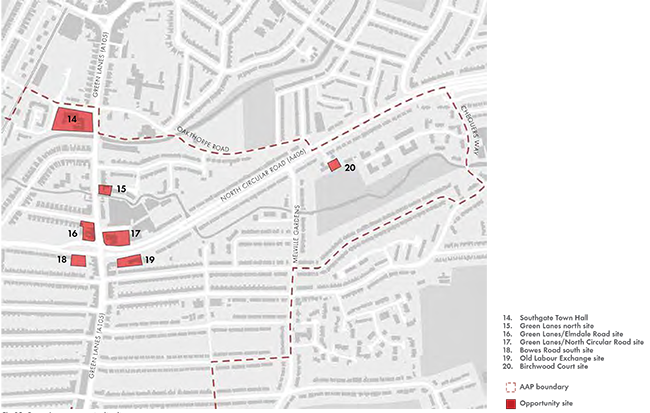
Fig 25. Green Lanes - opportunity sites
© Crown Copyright and database right 2012. Ordnance Survey Licence no. 100019820
Notwithstanding the option of the central Jehovah's Witness Hall being retained, the Council would respond constructively if proposals came forward for comprehensive redevelopment, in recognition that greater opportunities may exist to further strengthen the viability of the commercial element of the scheme through the provision of a consolidated, modern and purpose built accommodation with associated parking for the public. In view of the townscape value of the existing parade, emphasis would be placed on the need to deliver a high quality scheme which provides a visual reference point for those travelling along the main road corridor. Comprehensive change may also enable new development to be mixed use and of a higher density than currently exists; subject to the need to respect and be in keeping with local townscape character. Development must be of a high quality and make a positive architectural contribution to the local area. If comprehensive redevelopment of the Parade is being promoted it may be appropriate to consolidate the commercial uses to the central part of the site.
NC POLICY 24 BOWES ROAD SITES (SITE 13 - POWYS LANE TO BROOMFIELD ROAD)
This large site will deliver a range of housing types and present a strong built edge to Bowes Road taking advantage of existing access points into the site. Key principles relevant to the redevelopment of these sites include:
This large site has the capacity for the delivery of approximately 130 additional dwellings.
This is a major site with the potential to deliver a significant proportion of the new residential development envisaged for the area The site is deeper than many other sites given the alignment in the A406 and this enables new development to turn into the site whilst maintaining an acceptable relationship the properties along Westminster Drive whose gardens back on to the site. A new pedestrian at-grade crossing has been provided as part of the TfL improvements to the road corridor and this should improve the chance of new residents being able to support the short parade of local businesses on the opposite side of the A406.
The existing mature trees on the site are a particular asset and where possible these should be retained. The New River is nearby and to help improve the quality of the open space network in the area, there is an opportunity along Russell Road to improve a small public space along the New River path which has the potential to benefit the wider community.
The area is bound to the west by the railway lines, and the New River to the north as it sweeps east of Palmers Green. To the east the boundary is formed by Melville Gardens and Princes Avenue. The designated Large Local Centre of Green Lanes provides the focal axis for this predominantly residential area.
Opportunity sites (Fig 25)
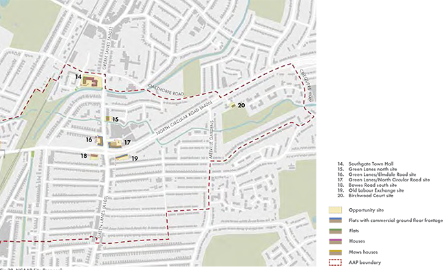
Development opportunities in this part of the AAP area are concentrated around the junction between the A406 and Green Lanes. In particular, the land on the northern side of this junction presents opportunities for redevelopment and investment (16 and 17) together with the Old Labour Exchange (19) adjacent to the petrol station on the south side of the road which is a particular local eyesore. Opportunities also exist further north along Green Lanes (15) and the Southgate Town Hall site (14), owned by Enfield Council, now benefits from a planning brief. Some smaller residential sites have been identified to the east of the area (20).
Local environments across the Green Lanes neighbourhood place


Fig 26. Green Lanes - activities
© Crown Copyright and database right 2012. Ordnance Survey Licence no. 100019820
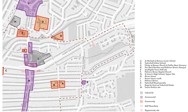
Fig 27. Green Lanes - townscape
© Crown Copyright and database right 2012. Ordnance Survey Licence no. 100019820
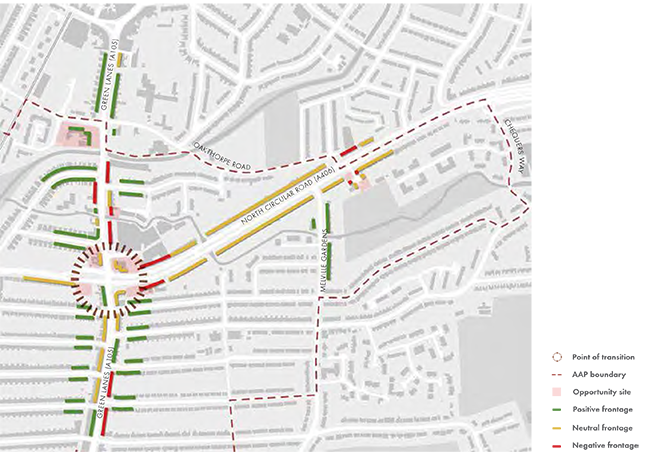
Fig 28. Green Lanes - movement
© Crown Copyright and database right 2012. Ordnance Survey Licence no. 100019820
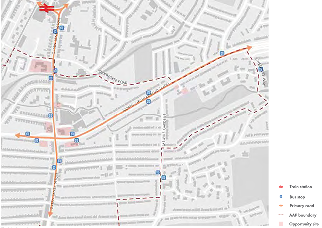
Fig 29. Green Lanes - open space
© Crown Copyright and database right 2012. Ordnance Survey Licence no. 100019820

Fig 30. NCAAP Site Proposals
© Crown Copyright and database right 2012. Ordnance Survey Licence no. 100019820
Activities (Fig 26)
The area is arranged around the commercial spine of Green Lanes. South of the A406 junction Green Lanes provides a wide variety of commercial uses which serve the everyday needs of local residents. North of the junction the commercial spine is more fractured with some ground floor residential uses being introduced.
The Regents Avenue Industrial Estate occupies a prominent location just behind the commercial unit on the north east corner of the junction. The majority of this site is occupied by a bus depot. The Enfield Employment Land Review 2012 recommended that the site is retained in the short to medium term for employment uses.
The Southgate Town Hall building is on the northern boundary of the NCAAP area and benefits from a planning brief which identifies a range of potential community uses that would be suitable within the existing building. Beyond that, schools and churches provide the main elements of community infrastructure across the area with Tottenhall Infant School and St Michael-at-Bowes Junior School located to the south east of the NCAAP area and St Anne’s Catholic High School for Girls just beyond the NCAAP boundary in Palmers Green. The Palmers Green Mosque and the adjacent Darji Pavilion are major community facilities for the local Muslim community.
Townscape (Fig 27)
The majority of the development sites are located along Green Lanes. The ancient thoroughfare of Green Lanes is one of London’s longest commercial streets and presents a diverse range of cultures which reflect the numerous communities it serves along its length.
South of the A406 the urban structure is composed of regular urban residential blocks with two storey, typically semi-detached housing addressing the street. These streets, oriented east-west, provide good and frequent access to Green Lanes. The townscape quality of Green Lanes itself is variable with some good quality parades which have retained their historic qualities, and some more fragmented stretches which would benefit from investment and, in places, redevelopment.
Unusually for a major intersection and in contrast to other major junctions along the route of Green Lanes, the junction with Bowes Road/A406 does not act as a particularly prominent node. However, given the magnitude of the junction which clearly acts as a major node on this major intersection, the buildings do not respond particularly positively. Whilst the buildings on the south side present an active commercial edge to the street at ground floor level, the pedestrian environment north of the junction is far less successful.
Beyond the junction to the north, Green Lanes becomes more fragmented as a commercial spine before the Palmers Green approach.
Movement and connections (Fig 28)
Palmers Green is the nearest railway station which provides train services into central London in under 30 minutes. The network of bus routes ensure the area is well connected with its hinterland. The routes serving the area include:
34 from Barnet High Street / Barnet Church to Walthamstow Bus Station
102 from Edmonton Green Bus Station to Brent Cross Shopping Centre
121 from Enfield Island Village to Turnpike Lane Station
141 from Green Lanes/A406 junction to London Bridge
232 from Stonebridge to Turnpike Lane Station
329 from Enfield to Turnpike Lane Station W4 from the Great Cambridge Road junction to Tottenham Hale
N29 from Enfield to Trafalgar Square
Public realm and open space (Fig 29)
This eastern part of the NCAAP suffers from a lack of publicly accessible open space. Larger spaces exist on both the north and south sides of the A406 but they are not generally publicly accessible. The waterways do provide an informal leisure and walking resource and, in particular, parts of Pymmes Brook and the New River Path are in good condition and act as a valuable local amenity.
NC POLICY 25 GREEN LANES NEIGHBOURHOOD PLACE
Key principles that will guide change in the Green Lanes neighbourhood place are as follows:
Across these sites there is potential for approximately 135 additional new dwellings supported by a range of commercial and other uses.
This general policy should be read in conjunction with more specific policies for larger/more significant development sites within the Green Lanes neighbourhood place.
Green Lanes is one of London’s longest and oldest high streets. This stretch of Green Lanes is varied with the southern end being part of the extensive commercial high street that stretches south to Wood Green and continues to Newington Green. There are continual, largely independent, commercial uses leading north up to the junction with the A406. On the north side of the junction this continuity is broken by some residential uses and more generally the street edge weakens and in this location Green Lanes no longer operates as a local high street.
The sites around the junction present the most significant development opportunities although ownership is mixed and generally fragmented which will make bringing the sites forward more difficult. The commercial sites on the south side are in reasonable condition with few vacancies and the buildings are occupied by residential uses on upper floors. The street benefits from a strong building line and both sides of the street contribute well to the local high street character. On the north side of the road the high street character is far less strong and the street is much weaker as a result. Whilst ownerships will again be fragmented, Green Lanes would benefit from these sites coming forward in the longer term and in doing so they would present a valuable opportunity to strengthen the role of this important junction.
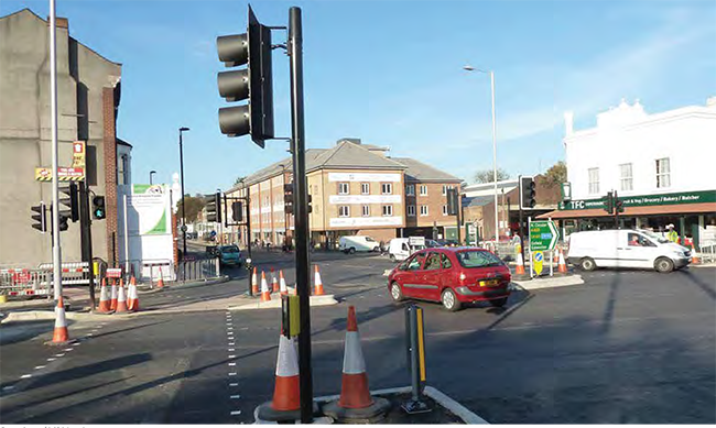
The junction is identified as a point of transition along the North Circular Road corridor. It is a key junction and acts as an important point of orientation. This role could be strengthened with the redevelopment of the sites on the north side if they came forward. The area around the junction is one of the more accessible locations in the Borough with a PTAL rating of 4. This, combined with the wide range of retail and community services and facilities along Green Lanes makes the location a highly sustainable one for new development.
Green Lanes/A406 junction
Other key sites include the Southgate Town Hall which has potential for ongoing community uses and some new residential development.
NC POLICY 26 SOUTHGATE TOWN HALL (SITE 14)
In accordance with the Southgate Town Hall planning brief, the principal spaces in the former town hall and library building will be retained refurbished and/or converted with appropriate uses including community and office/commercial uses. The site is also appropriate for new high quality residential development on the Shapland Way and New River frontages.
In addition to the refurbished floorspace, this site has the scope to deliver up to 35 dwellings.
The Southgate Town Hall planning brief was adopted in October 2011 and provides a planning framework for this prominent and important Council owned site. Protection is given to the existing community uses and new uses are identified as being appropriate future uses for the building. These include health uses should the need arise.
Prevailing building heights range from three storeys in Shapland Way with the new housing development opposite the site rising to four storeys. The site presents the opportunity to secure the long term community-based use of the building. The site does benefit from public access to the New River and a river frontage which is not something the current building exploits. There is public access to the river side. The opportunity to introduce new housing development on the western side of the site will enable the site to take advantage of this environmental asset. Care will need to be taken to protect the amenities of properties along Palmerston Crescent whose back gardens back on to the river opposite the site.
NC POLICY 27 GREEN LANES (SITE 15)
The site at the northern extents of the Green Lanes Large Local Centre is partly in flood zone 2/3 however, it still provides an opportunity to establish a more distinct relationship between the Palmers Green District Centre and the Green Lanes Large Local Centre. The Council will therefore steer development towards the area of lowest risk and take a flexible approach to proposed ground floor uses on sites in this location. Key principles relevant to the redevelopment of these sites indude:
Green Lanes in this location no longer operates as a local high street. Whilst commercial ground Boor uses may be appropriate. such uses are not considered a requirement in this location. Emphasis will be placed on the quality of the design and importance of delivering a building which addresses the street in an appropriate manna.
NC POLICY 28 GREEN LANES/A406 JUNCTION NORTH (SITES 16 AND 17)
The parcels of land either side of Green Lanes on the north side of the junction with the A406 present major opportunities for o new development to address the prominent corner. Key principles relevant to the redevelopment of this site include:
This is a prominent and Important junction along both the North Circular Road and Green Lanes. This Is one of a series of key points along the A406 corridor that provide the opportunity to provide a point of orientation. The road has been widened and the capacity of the 'unction Improved but the buildings which form this key junction. particularly on the north side. are low key and fall to address this key junction In a posnwe way.
NC POLICY 29 GREEN LANES/A406 JUNCTION SITE SOUTH WEST (SITE 18)
This is a small housing opportunity site. Key principles relevant to the redevelopment of this site include:
This site is regular In shape and presents an opportunity for new housing development which would benefit from the shops and services and public transport facilities provided nearby along Green Lanes. Access to the site would need to be resolved. There Is an existing service/ access lane to the rear of the Green Lane shops which has the potential to provide the site with vehicular/parking access although ensuring this provides an open and accessible access to the site at all times is likely to require further investigation.
NC POLICY 30 GREEN LANES/A406 JUNCTION SITE SOUTH EAST (SITE 19)
This former Labour Exchange site is suitable for mixed use development, with commercial/office accommodation on lower floors and apartments above. Key principles relevant to the redevelopment of this site include:
This small site. timely the local labour exchange. has remained undeveloped for some considerable time. Whilst it falls outside of the designated Green Lanes Large Local Centre. with Its prominent A406 frontage. It presents an opportunity for mixed use development. including commercial/office space. appropriate to Its setting between the petrol filling station and the Clock House retail parade. Subject to TfL's views and the nature of the proposed use and associated traffic generation. there is scope to establish access/egress to/from the site via both the A406 and Princes Avenue.
In terms of residential use. there Is scope for a small number of apartments on the upper floors of any new development subject to other relevant policies.
< Previous | ^ Top | Next >