
The Spatial Strategy sets out the overall approach for the provision of new homes, jobs, infrastructure and community facilities over the plan period. It sets the context for the Core Policies and outlines how the Vision and Objectives will be achieved.
The Spatial Strategy directs development towards the most sustainable locations, as illustrated by the Key Diagrams, and plans for supporting facilities and infrastructure to create sustainable local communities. The Strategy emphasises the importance of the Town Centre and regeneration to help Colchester to fulfil its potential as a prestigious regional centre for the Haven Gateway sub-region and wider Eastern region, with key links to London and Europe.
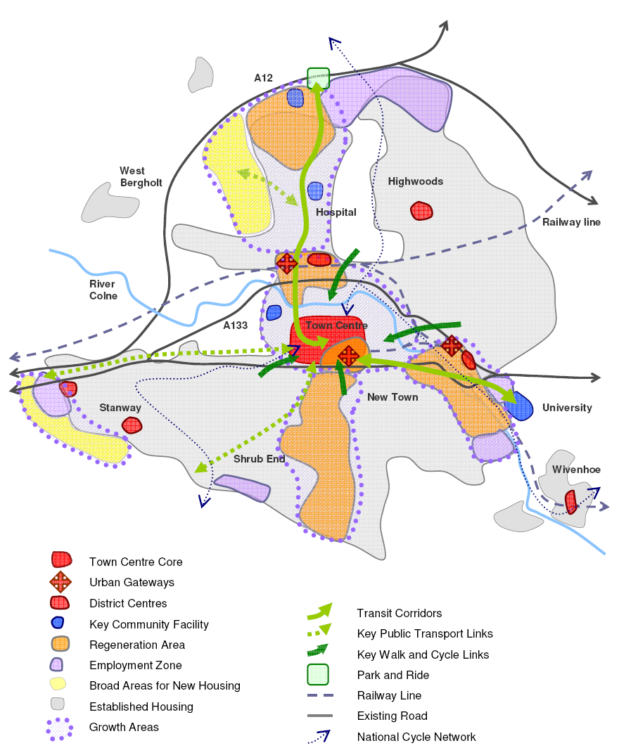
Colchester Town
The Council will focus the majority of future development on the following
growth areas, and will work with partners to deliver the infrastructure
and facilities needed to support this growth:
Focusing development at these locations will support regeneration, promote sustainable lifestyles and preclude large amounts of greenfield development. However, it is essential that development is well designed and supported with transport and utilities infrastructure, open space and community facilities.
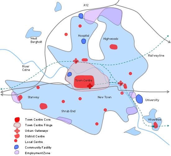
Town Centre
Colchester’s historic Town Centre is the cultural and economic
heart of the Borough. The Town Centre will be enhanced through regeneration,
public realm improvements, and a balanced mix of uses that sustain activity
throughout the day and evening. However, the capacity of the historic
core is limited and the extent of the functional Town Centre needs to
be expanded. Other areas around the Town Centre, including the train
station gateways, are highly accessible and currently perform important
town centre functions. The Core Strategy seeks to expand our concept
of the Town Centre to include these fringe areas and gateways.
Over the plan period it is projected that approximately 2000 new homes will be delivered in the Town Centre, including over 1,500 homes that have already been completed or permitted. In addition, Colchester’s Town Centre needs to accommodate more business, tourism and retail developments, including 67,000sqm of net retail floorspace and 40,000sqm of gross office floorspace between 2006 and 2021. The Town Centre will also be the primary location for the delivery of 270-490 hotel bedrooms between 2006 and 2011, and additional hotel developments beyond this period. These targets reflect the findings of current studies assessing Colchester’s retail, business, and hotel requirements. This development will be primarily focused on the Town Centre, and other highly accessible locations, to create a sustainable and prestigious regional centre.
The Council therefore needs to actively promote and facilitate urban renaissance in the Town Centre and the regeneration of the St Botolphs and North Station areas. The regeneration of St Botolphs will deliver the following key projects:
The regeneration of the North Station area will deliver the following:
Transport improvements will also be made to the Town Centre’s historic core to improve access and manage congestion. The Council seeks to enhance the pedestrian environment and reduce traffic on the High Street, and facilitate better bus access and circulation in the historic core.
Diagram of Centres and Employment Zones
North Growth Area
Mile End is a suburban area that has experienced rapid residential growth
in the recent past. The area provides good access to the Town
Centre, North Station, the A12 (upon completion of a new A12 junction),
open space and Colchester General Hospital.
Between 2001 and 2021, approximately 4000 new homes will be delivered in the established urban areas. The majority of this housing (approx 3,500) has already been constructed or permitted. The Core Strategy also identifies additional greenfield land to the west of Mile End Road with capacity for 2,200 homes. It is intended that this land will come forward between 2016 and 2023, although the timing and delivery of the greenfield sites will be kept under review and brought forward if necessary. The achievement of zero carbon development is expected to be in accordance with national planning policy requirements in place at that time.
North Colchester is also identified as a Strategic Employment Zone. Cuckoo Farm offers approximately 19.8ha of employment land that will provide good access to the A12.
The Core Strategy will coordinate this housing and employment development with the delivery of transport infrastructure, community facilities and open space. Key projects to be delivered within the North Growth Area include:
East Growth Area
The Hythe area is a former commercial harbour which includes some rundown
and underused industrial land. Together with the University of Essex
and New Town, this eastern area of Colchester has entered a period of
significant growth. The area provides good access to Hythe Station,
University of Essex and the Town Centre, but is constrained by limited
transport infrastructure and flooding issues.
East Colchester is an established Regeneration Area that seeks to deliver sustainable, mixed use neighbourhoods oriented towards the River Colne and which respect the historic character of the area as the location of the early port. Over the plan period the East Growth Area provides capacity to accommodate at least 2,600 new homes, including over 1,500 homes that have already been completed or permitted. Once local traffic and flooding issues are resolved, then additional development will be encouraged at this highly accessible location. The regeneration of this area therefore needs to be supported by improvements to transport infrastructure, flood mitigation and open space.
Key projects to be delivered within the East Growth Area include:
South Growth Area
The Garrison area in the south of Colchester is an established regeneration
area that provides significant potential for redevelopment within close
proximity to the Town Centre. The new Garrison is currently under construction
and will provide approximately 5000 direct jobs. A master planned urban
village has been approved on the old Army Garrison site to accommodate
2,600 homes. Recently, the progress of development and detailed planning
permission indicates that housing delivery is likely to exceed 3000
during the plan period. This additional housing delivery needs to be
supported through improvements to transport infrastructure and community
facilities.
Key projects to be delivered within the South Growth Area include:
Stanway Growth Area
The western and south-western fringes of Stanway will also be subject
to significant development during the life of the plan. Existing allocations
for both employment and housing will continue to be developed during
the plan period. Stanway is identified as a Strategic Employment Zone
and provides approximately 16ha of employment land that will provide
good access to the strategic road network (A12). Existing housing allocations
will deliver approximately 1000 homes by 2021. Furthermore, urban extensions
to the west and south west are intended to deliver 800 homes. It is
intended that this land will come forward between 2016 and 2023, although
the timing and delivery of the greenfield sites will be kept under review
and brought forward if necessary. The achievement of zero carbon development
is expected to be in accordance with national planning policy requirements
in place at that time. This development will provide protection
for sites of archaeological significance as well as facilitate delivery
of strategic public open space and road improvements which will improve
the highway network to the south and west of the town.
Key projects to be delivered within the Stanway Growth Area include:
District Settlements
Tiptree, Wivenhoe and West Mersea are the main district settlements
outside of Colchester Town. These settlements provide an important range
of shopping, services and facilities to their surrounding rural hinterland.
Tiptree had a population of 8,305 in 2001 and is the largest settlement in the Borough outside of Colchester Town. Over the plan period it is projected that approximately 680 new homes will be developed in Tiptree, including 500 homes (approx) that had already been completed or permitted in 2006. This may also include the reallocation of surplus employment land. An additional 245sqm of net retail floorspace will also be sought in the district centre. All this development will help regenerate Church Road and deliver open space and community facilities. Key facilities to be delivered in Tiptree include a new health centre, expansion of the primary school, new sports pitches and allotments.
Wivenhoe had a population of 7,221 in 2001 and has good connections to the University of Essex, Colchester Town, and regional train services. Over the plan period, approximately 635 homes will be developed in Wivenhoe and across the water in Rowhedge, including recent developments in Wivenhoe the regeneration of Rowhedge Port. An additional 126sqm of net retail floorspace will also be sought in Wivenhoe’s district centre. Key facilities to be delivered in Wivenhoe include a new health centre, youth facilities and community hall improvements.
West Mersea, with a population of 6,925 in 2001, is a relatively self-contained coastal community offering quality tourism and recreation opportunities. The West Mersea waterfront will be conserved for its historic maritime character and distinctive maritime-related local businesses. There are some limited development opportunities in West Mersea and approximately 280 new homes will be developed during the plan period, including over 200 homes that have already been approved or completed. An additional 173sqm of net retail floorspace will also be sought to service the residents of Mersea Island. Key facilities to be delivered in West Mersea include allotments and a new health centre.
Rural Communities
The villages in the borough are unlikely to experience significant development
during the plan period. Overall, about 705 homes are likely to be developed
in rural communities throughout the borough. Approximate 650 of these
homes had been completed or approved in 2006, including 150 new homes
in Great Horkesley. The priorities in these villages will be protecting
the distinct local character and supporting the provision of affordable
housing, open space, rural employment, key services and community facilities.
Separation will be maintained between Colchester and adjoining settlements in order to protect village identity and landscape character.
Environment
The natural environment, countryside and coastline will be conserved
and enhanced to protect the Borough’s biodiversity, landscape,
geology, history and archaeology. Development will be directed away
from sites of international, national, regional and local importance,
areas of landscape conservation importance and land at risk from fluvial
and coastal flooding. Where new development requires a rural location,
it will need to enhance the locally distinct character of the landscape,
in accordance with the Landscape Character Assessment. The Dedham Vale
Area of Outstanding Natural Beauty will be protected from inappropriate
development. The open and undeveloped coast within the Coastal Protection
Belt will be protected from development that would harm its open and
rural character. Management will focus on balancing the rural land uses
that have shaped the landscape with opportunities to enhance and promote
tourism and recreation.
The River Colne provides a valuable green corridor, for both wildlife
and people, from Colchester Town to the countryside and coastline.
Subject to flood risk assessment, the regeneration of previously developed
land will be supported at appropriate locations along the river to enhance
its recreation and nature conservation values. Strategic open spaces
and green links, such as the river corridor, will be maintained and
enhanced to support movement, recreation and biodiversity.
The Abberton Reservoir will be expanded to help meet increasing water demands in the region. This expansion will include improved visitor access and a new visitor centre to provide for recreation and education.
Transport Strategy
Accessibility and transport are key elements of the Core Strategy and
the Council will prepare Transport Strategy as part of the Local Development
Framework to reflect Colchester’s role as a Regional Transport
Node. This Transport Strategy will accord with the Regional Transport
Strategy and the Local Transport Plan, and will aim to achieve the following
through partnership working:
In practice, the achievement of these aims requires a long-term strategy coordinating development and transport to support sustainable lifestyles and address climate change. Accordingly, the Spatial Strategy and Transport Strategy seek to coordinate the following through partnership working:
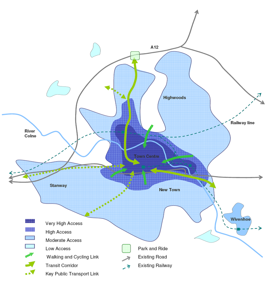
The Transport Strategy will also seek to create attractive and high quality gateways to Colchester to create a prestigious regional centre and promote sustainable travel behaviour. The main public transport interchanges, including North Station, Hythe Station and Town Station, will be regenerated to provide attractive ‘urban gateways’ to the Town Centre. The new A12 junction, including Park and Ride, will also provide a quality gateway for vehicular access to Colchester Town.
The key transport measures outlined above will substantially improve people’s access to jobs, shops, services and facilities in the Borough. The following diagrams below provide a conceptual illustration of the accessibility improvements to be achieved through investment in transport infrastructure and services
Diagram of Present Accessibility and Transport
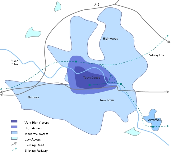
Diagram of Future Accessibility and Transport
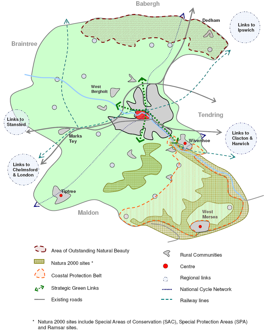
The Key Diagrams provide conceptual illustrations of the Core Strategy. The first Key Diagram illustrates the Strategy at a Borough-wide scale, whilst the second Key Diagram focuses on the complexities of Colchester Town. These Diagrams present the spatial principles of the Strategy and identify broad locations that relate to Core Policies, but are not intended to be detailed or site specific.
KD1: Colchester Borough
KD2: Colchester Town
< Previous | ^ Top | Next >