
Introduction
6.1.1 This chapter sets out the planning policies to deliver forecast significant employment growth and the business and Town Centre objectives outlined earlier in the Vision and Objectives.
6.1.2 Employment in the Borough is forecast to increase by 22% from 116,000 jobs in 2011 to 141,000 jobs in 2031 (GLA 2016 Labour Market Projections). The Local Plan evidence base identifies a significant requirement for office space, driven by business services and financial services, as well as growth in employment in utilities, wholesale, retail and transport/storage. Bromley has one of the largest economies of London boroughs outside the Central Activities Zone.
6.1.3 Despite some decline of manufacturing employment in the Borough, industry and warehousing remain important elements of the local economy. There are approximately 120 hectares of land in industrial or warehousing use, the majority being concentrated within the Business Areas in the Cray Business Corridor, Lower Sydenham (Kangley Bridge Road), Elmers End and Biggin Hill.
6.1.4 St Mary Cray is the largest of the areas with just under 40 hectares used for light industry or warehousing. It is the area with the best connections to the M25 and is the Borough's prime location for such businesses. Both Lower Sydenham and Elmers End have relatively good connections to Central London. The Business Area at Biggin Hill provides premises that benefit from close connections with the aviation industry and with air transport facilities.
6.1.5 Bromley Town Ward is the main location for the Borough's office-based businesses, with approximately 132,000sqm of floorspace, almost half of the total office floorspace in the Borough. Orpington, which benefits from close links with the M25, has the next largest concentration with approximately 22,000sqm. The remainder is mainly distributed amongst the Borough's District Centres.
6.1.6 It is important to consider how best to protect the Borough's employment lands and office accommodation for future business needs, whilst encouraging improvements to the existing stock and quality of environment. This will require nurturing growth of the office market in the Borough’s Town Centres and Office Clusters over the short, medium and long term given the highlighted anticipated demand for such floorspace.
6.1.7 The continued challenging economic climate highlights the need to continue to ensure Bromley achieves this vision through clear designations, identifying where growth and investment will be encouraged. Economic growth is important to achieving the long term overall vision of Building a Better Bromley and the protection of sufficient land and premises to accommodate the forecast growth.
6.1.8 Bromley’s network of town centre and business sites provide employment services and facilities for residents and the wider communities.
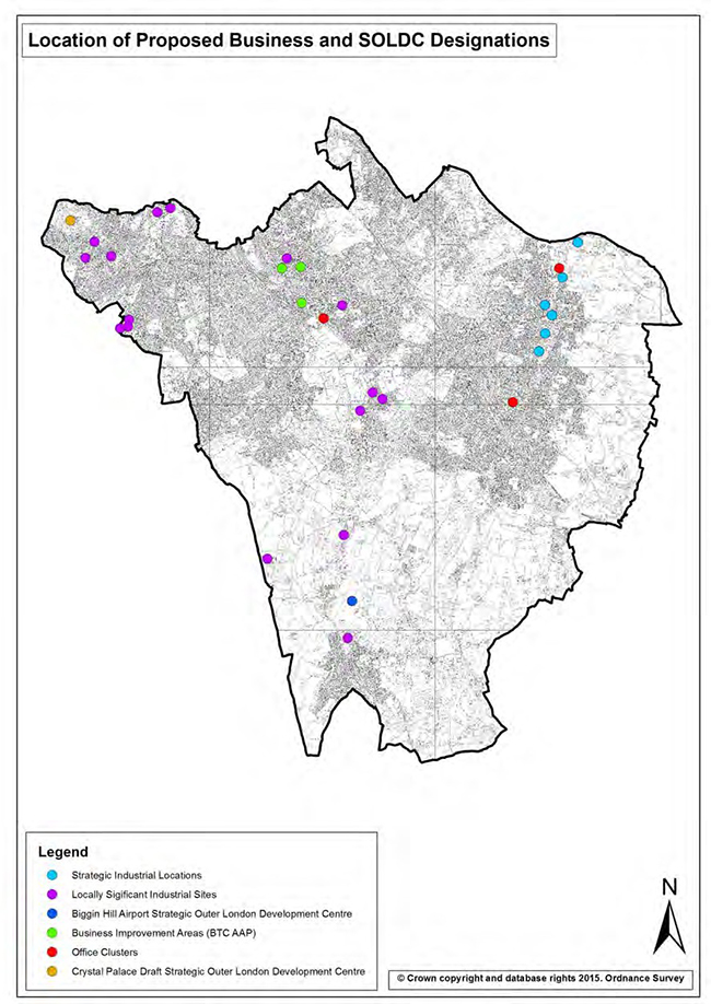
Map: Bromley Business and SOLDC designations
| Policy 80 Strategic Economic Growth The Council has identified three strategic priority areas for economic growth:
|
Supporting Text
6.1.9 The Council’s evidence base and the GLA's trajectory for Borough employment growth highlight the need to provide a range of modern good quality floorspace to meet employment forecasts in the Borough. In addition, the Council is seeking to encourage a higher level of economic growth and have identified three areas – Bromley Town Centre, Crays Business Corridor and Biggin Hill Airport, given their strategic importance (Metropolitan Town Centre, Strategic Industrial Location and Strategic Outer London Development Centre). To meet the needs of new and growing businesses, the Council will work with businesses and other partners to ensure the supply of quality employment floorspace.
6.1.10 This strategic policy sets the context for the Working in Bromley section of the Local Plan and acknowledges the National Planning Policy Framework's (NPPF) approach to building a strong, competitive economy, and the commitment to securing economic growth in order to create jobs and prosperity.
Map: Strategic Economic Growth Locations

Industrial Land
6.1.11The London Plan identifies Bromley as a ‘restricted’ borough in regards to the transfer of industrial land to other uses. The Strategic Industrial Locations (SIL) and Locally Significant Industrial Sites (LSIS) have been designated in line with the London Plan’s economic and employment policies. The Foots Cray Business Area and St Mary Cray have been identified as SILs (sub-category Industrial Business Park) in Annexe 3 of the London Plan and Policy 2.17 and require boroughs to promote, manage, and where appropriate, protect SILs. LSISs are located across the Borough and are of particular importance for industrial uses.
| Policy 81 Strategic Industrial Locations (SIL) In the designated SIL, the following uses will be permitted and safeguarded:
Proposals in the SIL for Class B uses that include a quantum of floorspace to be used for display and sales should demonstrate that this quantum of floorspace is clearly ancillary to the primary Class B uses. On land in the SIL identified as an Office Cluster, Class B1(a) uses will be permitted as a primary use for the land, provided that the use does not impede effective operation of other nearby businesses in the SIL. On land elsewhere in the SIL, proposals involving a Class B1(a) use should demonstrate that the use is clearly ancillary to a primary Class B1(b), B1(c), B2 or B8 use. Proposals for waste management and disposal installations will be permitted, provided that the use does not impede the effective operation of other nearby businesses in the SIL or the primary function of the SIL as an Industrial Business Park. |
Supporting Text
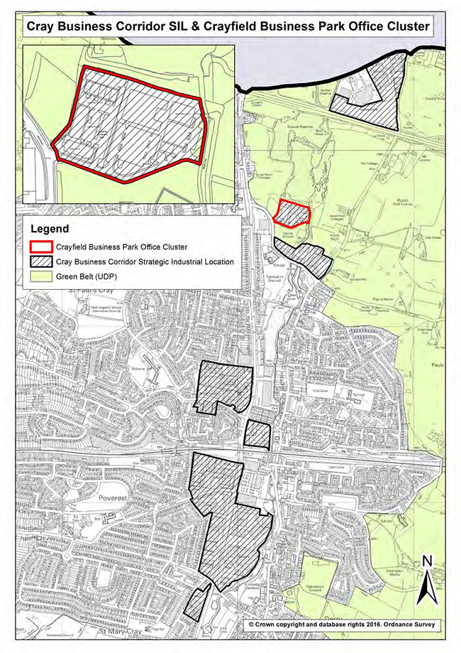
6.1.12 The Cray Business Corridor is one of three major employment areas within the Borough that could accommodate significant growth over the next fifteen years. The Corridor represents just under 40% of all designated industrial/employment land (46.6 hectares) in the Borough and includes St Mary Cray, the largest industrial/employment area in the Borough, as well as Crayfields and Ruxley Corner (Foots Cray).
6.1.13 The Cray Business Corridor provides a key opportunity to provide floorspace to meet the demands of modern industry and business to secure a balance of employment jobs in terms of type and quality across the Borough.
6.1.14 The Council acknowledges that a variety of uses currently exist in the Cray Business Corridor, including land identified as an Office Cluster under Policy 85 Office Clusters. The council intends to safeguard industrial Class B operations, but not forgo proposals that create additional employment opportunities where existing non industrial uses exist, providing they fit in with the function and operation of the industrial area and its designation as an Industrial Business Park. This is in conformity with the London Plan and reflects the Borough’s status as a ‘restricted’ borough for the transfer of industrial land to other uses.
6.1.15 Small scale walk-to services, such as a workplace crèche or café which meet the essential day-to-day needs of industrial occupiers in the SIL, will generally be permitted, provided that the proposed use is necessary to support industrial activity and it would not adversely affect the industrial status or operation of the area. To ensure an appropriate balance of employment uses, the Council will restrict further expansion of retail floorspace in the SIL to instances where the use is demonstrated to be ancillary to a primary Class B use.
6.1.16 This policy approach provides support for the intensification, and upgrading, of the area to meet expected future business needs, particularly the forecast growth in Class B1 based employment. This will encourage business growth and investment in line with the SIL (Industrial Business Park) designation, to include modern high quality business accommodation.
Map: Strategic Industrial Locations (SIL)
| Policy 82 Locally Significant Industrial Sites (LSIS) In the designated LSISs, the following uses will be permitted:
|
Supporting Text
6.1.17 LSISs provide a wide range of premises for Class B uses and should be afforded protection where there is a demand for such sites. It is important to avoid the long-term safeguarding of land for a particular purpose, where there is no reasonable prospect of sites being used for that purpose (as per Paragraph 22 of the NPPF). The Council will support refurbishment, redevelopment and intensification of sites that incorporate a flexible design, in order to readily accommodate a range of Class B uses for the medium and long term. Larger scale developments, in particular for Class B8 uses, are better suited to the Cray Business Corridor SIL.
6.1.18 Small scale walk-to services, such as a workplace crèche or café which meet the essential day-to-day needs of industrial occupiers in LSISs, will generally be permitted, provided that the proposed use is necessary to support industrial activity and it would not adversely affect the industrial status or operation of the area. To ensure an appropriate balance of employment uses, the Council will restrict further expansion of retail floorspace in LSISs to instances where the use is demonstrated to be ancillary to a primary Class B use.
6.1.19 Where it is demonstrated that existing premises cannot viably accommodate a quantum of Class B floorspace in the medium and long term, the Council will consider employment-led mixed use proposals that are consistent with the primary function of the LSIS and do not impede the effective operation of existing employment uses in the vicinity. In considering these proposals, the Council will require evidence that recent, active marketing of the site for reuse or redevelopment for Class B purposes has been undertaken for a reasonable timescale. Marketing should be undertaken in both traditional and web-based formats, through a property consultant or estate agent, reflecting the marketing value for the permitted uses on that land (based on evidence from recent and similar transactions and deals) and including lease terms and conditions that are reasonable and attractive to potential businesses. The Council considers a reasonable timescale to determine market demand on sites within an LSIS to be at least two years, consistent with the Mayor’s SPG Land for Industry and Transport (2012).
Areas designated as LSIS
6.1.20 The following areas are designated as LSIS:
| Policy 83 Non-Designated Employment Land The Council will seek improvements to the quality and quantity of employment floorspace on sites containing existing industrial and related employment uses outside designated SILs and LSISs. Proposals for change of use or redevelopment of non-designated sites containing Class B uses for alternative employment generating uses will normally be allowed provided that the amenity of any nearby residential areas is not detrimentally affected. Proposals for change of use of non-designated sites accommodating Class B uses to a non-employment generating use will be considered on the following criteria:
|
Supporting Text
6.1.21 As the value of new residential development continues to rise, there is an increasing pressure on the supply of business sites across the Borough. Many of the established industrial/employment sites within or neighbouring residential areas are particularly under threat.
6.1.22 These sites serve an important purpose in the Borough, accommodating small business units that often cannot for various reasons be located satisfactorily in an area designated for industrial/employment purposes. It is therefore important to retain a range of accommodation for different business uses, unless there are significant reasons as to why their continued business use is not feasible.
6.1.23 The purpose of this policy is to set out clear criteria for change of use proposals including requirements for applicants to examine other employment generating uses on site, including non-traditional industrial employment uses such as trade counters and wholesale retail premises. This is in accordance with Paragraph 22 of the NPPF and allows the renewal of genuinely obsolete sites.
6.1.24 In considering a proposed change of use on these sites, the Council will require evidence that recent, active marketing of the site for reuse or redevelopment for employment generating uses has been undertaken prior to submission of the planning application, over a minimum period of six months. Marketing should be undertaken in both traditional and web-based formats, through a property consultant or estate agent, reflecting the marketing value for the permitted uses on that land (based on evidence from recent and similar transactions and deals) and including lease terms and conditions that are reasonable and attractive to potential businesses.
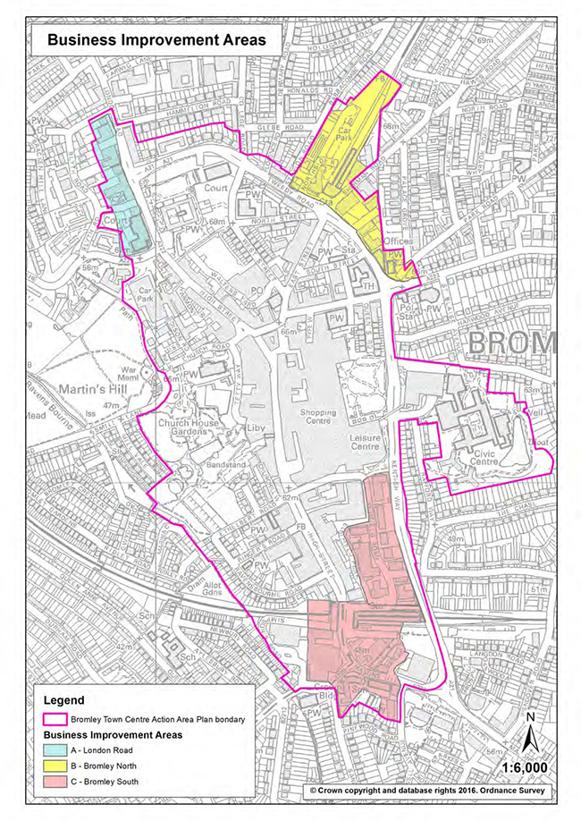
| Policy 84 Business Improvement Areas (BIA) The Council will seek to manage and improve the supply of high quality office floorspace in Bromley Town Centre through designating the following as BIA:
|
Supporting Text
6.1.25 The BIAs located in Bromley Town Centre (identified in the following Map) have been identified for their good quality purpose built office's to create a high quality business environment for the retention of existing businesses and new business development. Article 4 directions are in place within the designation areas, removing the permitted development rights to change from office to residential use.
Map: Business Improvement Areas (BIA)
| Policy 85 Office Clusters The Council will work to retain and manage an adequate stock of good quality office floorspace in the Borough through safeguarding the following as Office Clusters:
|
Supporting Text
6.1.26 Office employment is forecast to be the greatest area of growth over the plan period and it is essential that the Borough provides a range of good quality offices. The Office Clusters (identified in Appendix 10.13) are allocated in the main areas outside of the town centres to help ensure key employment growth within the local economy. The Office Cluster evidence base outlined sites that would give a positive contribution to the vitality and viability to their local areas. Planning policy at national, regional, and local levels seek to protect and enhance both town centres and high streets.
6.1.27 There has been a significant loss of office space within the Borough attributed to Permitted Development Rights (PDR) for conversions of offices to residential use. The pressure on offices for other uses is recognised in Policy 4.2 of the London Plan, where boroughs are encouraged to monitor the impacts of PDR, and where appropriate protect, renew and modernise existing office stock in viable locations to improve quality and flexibility.
6.1.28 It is important to maintain an adequate supply of good quality office accommodation to accommodate new and existing business and plan for the forecast employment growth over the Plan period.
6.1.29 The Council recognises and supports the importance of these office locations and will seek to protect them.
| Policy 86 Office Uses Outside Town Centres and Office Clusters Proposals for new office development will be expected to be located within designated Town Centres (provided that the retail function of the town centre is not impaired) and Office Clusters. On sites outside designated Town Centres and Office Clusters, proposals for Class B1(a) will be permitted, provided that they are consistent with Town Centres Policies. The redevelopment or change of use of existing Class B1(a) use sites outside of Town Centres and Office Clusters for non-Class B1(a) uses will be permitted, provided that:
|
Supporting Text
6.1.30 The aim of the Council’s office policy approach is to safeguard sufficient land for office based employment in the most appropriate locations (such as the BIAs in Bromley Town Centre for large offices and the established office clusters), and restrict the release of purpose-built large offices through a criteria based approach which considers the market and favours retaining employment generating uses on sites.
6.1.31 Other than in the BIAs, a more flexible approach to enable other employment uses, including mixed use is preferred. A significant proportion of employment generating space should be provided in mixed use schemes and schemes should upgrade the employment space. This ensures the core office market in Bromley Town Centre is protected, and the more local office clusters.
6.1.32 When submitting a planning application for change of use, it is not sufficient to demonstrate that there is no demand for the existing offices on the site. It is also necessary to explore the potential to upgrade the building to meet modern requirements, or to adapt the building to meet the needs of smaller firms.
| Policy 87 Home Working In cases where planning permission is required, the Council will normally permit the use, by the householder, of part of a dwelling for business purposes only where:
|
Supporting Text
6.1.33 The aim of this policy is to ensure that home working can take place, residential areas remain attractive and peaceful places to live, and that the living conditions of those surrounding the activity are not adversely affected.
6.1.34 Changes in the structure of the economy and the advancement of technology that enables effective home working has changed the way we work. More people now work from home on a regular basis and it is anticipated that this trend will continue. Home working avoids expensive and time consuming commutes, improving the quality of life for individuals and families in the Borough. Planning permission is only required where there is a material change in the character of the use of the dwelling. The key test is to consider whether a property remains primarily a home.
| Policy 88 Hotels Proposals for a hotel will be permitted provided that:
|
Supporting Text
6.1.35 The London Plan aims to support London’s visitor economy and stimulate its growth to ensure that London expands as a global tourism destination. The Plan outlines the need for 40,000 additional hotel rooms by 2036 in a variety of suitable locations throughout London with good public transport access to Central London.
6.1.36 Proposals for hotel development should be located in town, district, or local centres and will be assessed on their impacts to the environment and transport network.
| Policy 89 Telecommunications Development In a development involving telecommunication mast, base station or apparatus, applicants will be required to demonstrate that:
|
Supporting Text
6.1.37 This policy applies to various types of commercial telecommunications apparatus including purpose built masts, cellular radio antennae, terrestrial microwave antennae and satellite antennae or dishes.
6.1.38 Whilst certain telecommunications development does not the Council’s express consent, where permission is required, the primary consideration is the minimal visual and environmental harm and the respect of the local character.
6.1.39 Paragraph 43 of the NPPF states that local planning authorities should support the extension of electric communications networks, including telecommunications and high speed broadband.
6.1.40 Building Regulations coming into force in January 2017 state that telecommunications must include broadband as standard procedure excluding only certain types of buildings or those in rural areas. This will apply to erection of all buildings and to major renovation works to buildings, subject to some exemptions and applied criteria.
6.1.41 Telecommunications apparatus can have a deleterious effect upon an area. Unlike most other forms of development, traditional materials appropriate to a specific location cannot be used. Buildings which are listed or located in Conservation Areas are exempt from the requirement under paragraph 1.5.
6.1.42 This policy aims to keep the numbers of radio and telecommunications casts and the sites for such installations to a minimum consistent with the efficient operation of the network. Existing masts, buildings and other structures should be used, unless the need for a new site has been justified. Where new sites are required, equipment should be sympathetically designed and camouflaged where appropriate.
Introduction
6.2.1 This section focuses on the main policies to assist in meeting the objectives relating to Town Centres and shopping areas which are set out in the Vision and Objectives Chapter earlier. The policies aim to help maintain and enhance the roles of different centres. The network of Town Centres and Local Centres is central to the quality of life and well-being of Bromley’s communities providing a wide range of services and facilities.
Town Centre and Shopping Hierarchy
6.2.2 The shopping hierarchy of the Borough’s established centres has evolved over a considerable period of time and is recognised in the London Plan. The centres are classified according to their existing role and function and each performs a different but complementary role. The hierarchy is important in providing a range of services and facilities across the Borough.
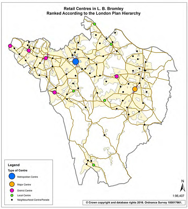
6.2.3 The National Planning Policy Framework (NPPF) requires the Council to define its Town Centre boundaries and primary and secondary frontages in designated Town Centres and set policies that make clear which uses will be permitted in such locations. The following Map shows the Town Centres and shopping areas in the Borough ranked according to the London Plan Hierarchy. Appendix 10.9 shows primary and secondary frontages for all designated centres. The Policies Map includes detailed maps of Bromley, Orpington, and the five District Centres.
Map: Town Centre and Shopping Hierarchy
| Policy 90 Bromley Town Centre Opportunity Area The Council will prepare an Opportunity Area Planning Framework for Bromley Town Centre to deliver a minimum of 2,500 homes and an indicative 2,000 jobs and maximise its contribution to the vision and objectives of the Local Plan. This will form an early review of the Bromley Town Centre Area Action Plan and implementation of the Bromley Town Centre Housing Zone, as agreed by the Mayor in 2016, to promote Bromley's strategic role as a Metropolitan Town Centre and the Opportunity Area description in Table A1.1 of the London Plan. The review will:
|
Supporting Text
6.2.4 Bromley Town Centre has historically been and still is the main retail centre for the Borough and its status is reflected in the London Plan. The centre has a night-time economy of regional/sub-regional importance and has the potential to accommodate a wider leisure and cultural offer.
6.2.5 The Bromley Town Centre Area Action Plan (BTCAAP) was adopted in 2010 and is guiding development in the Town Centre, in conjunction with the saved policies of the UDP. A number of the BTCAAP sites are under development or with planning permission subject to S106 agreements and expected to commence in the next year or two. The Town Centre has benefited from a comprehensive programme of improvements in recent years, funded both from the Council and Mayor's fund. Newer improvements have included extensive public realm upgrades to Bromley North Village and new signage and shopfronts.
6.2.6 The London Plan identifies the Town Centre as an Opportunity Area with the potential for delivering a minimum of 2,500 homes and an indicative 2,000 jobs.
6.2.7 Policy 76 includes Bromley Town Centre, as one of the three strategic areas for economic growth within the Borough.
6.2.8 The Town Centre is one of 13 Metropolitan Town Centres designated in the London Plan. It has a high growth designation reflecting the town's capacity to accommodate strategically significant levels of retail, leisure and office growth.
6.2.9 The Town Centre already contributes to the Local Plan housing provision, however, a review of the BTCAAP and preparation of an Opportunity Area Planning Framework will help identify further capacity to exceed the London Plan housing figures for the Borough and the indicative capacity identified in the Opportunity Area description in Table A1.1 of the London Plan.
| Policy 91 Proposals for Main Town Centre Uses The Council will require main Town Centre uses to be located within designated Town Centres or, if no in-centre sites are available, sites on the edge of centres. Only if suitable sites are not available in Town Centres or in edge of centre locations should out of centre sites be considered. Proposals for new main Town Centre uses outside of existing centres will be required to meet the sequential test as set out in the NPPF. Proposals for retail, leisure and office development outside of the Town Centres, over 2,500 sqm should include an assessment of:
|
Supporting Text
6.2.10 The NPPF sets out that local planning authorities should apply a sequential test to planning applications for main Town Centre uses that are not in an existing centre and are not in accordance with an up-to-date Local Plan. They should require applications for main Town Centre uses to be located in Town Centres, then in edge of centre locations and only if suitable sites are not available should out of centre sites be considered. When considering edge of centre and out of centre proposals, preference should be given to accessible sites that are well connected to the Town Centre. Applicants and local planning authorities should demonstrate flexibility on issues such as format and scale.
6.2.11 Bromley Town Centre's function is primarily as a comparison goods shopping destination. The BTCAAP sets out that the total retail floorspace of the Town Centre is approximately 115,20sqm (including Bromley Shopping Centre, also known as the Glades, which comprises 40,700sqm and The Mall 10,780sqm). The 2012 Retail, Office, Industry and Leisure Study (DTZ, 2012) concluded that Bromley Town Centre could accommodate capacity for a further 10,700sqm net of comparison floorspace at 2016; rising to 23,100sqm by 2021 and 37,700sqm by 2026 if forecast trends occur.
6.2.12 This study will be updated as part of the early review of the BTCAAP.
| Policy 92 Metropolitan & Major Town Centres The Council will require development within Bromley Town Centre to contribute positively to the town’s status as an Opportunity Area and to its role as a Metropolitan Centre. Proposals within Bromley Town Centre will be expected to have regard the objectives set out in the Area Action Plan adopted 2010. The Council will require development within Orpington Town Centre to provide a range of uses that will contribute towards its role as a Major Centre. Within the primary frontages in Bromley and Orpington Town Centres, as set out on the defined maps the Council will consider a change of use away from Class A1 where the proposal would meet all of the following criteria:
|
Supporting Text
6.2.13 Bromley is the largest retail centre in the Borough and caters for the wider community in terms of retailing and leisure opportunities. As well as being the main retail centre it is the only Metropolitan Centre within the Borough and has the largest concentration of offices and businesses.
6.2.14 The BTCAAP will ensure that Bromley continues to maintain its designated position in the retail hierarchy as a Metropolitan Centre and continue to make it a vibrant place where an increasing number of people want to live, work and shop. Major renewal of Bromley Town Centre including public realm improvements is underway and sites identified within the BTCAAP are currently under construction. This will increase the town’s position in the retail rankings and provide an attractive environment for new businesses to locate. The former Opportunity Site A (Land adjoining Bromley North Station) is included as a Site Allocation, together with an enlarged Site G (now including Bromley South) and revised proposals at Site F (Civic Centre site) (see Appendix 10.2).
6.2.15 Orpington Town Centre is designated as a Major Centre in the London Plan and the second largest retail centre in the Borough and only Major Centre. Major Centres generally have a high proportion of comparison goods relative to convenience and may also have significant employment, leisure, service and civic functions. Orpington High Street and the adjacent Walnuts Shopping Centre contain a wide selection of high-street shops. The public realm improvements made to Orpington Town Centre coupled with the new Bromley College campus development and the new cinema and leisure complex in the Walnuts will reinforce its Major Centre function and improve its overall offer to shoppers, visitors and residents. New developments will be expected to contribute towards the function of Orpington as a Major Centre. The provision of offices may be considered appropriate as part of a mixed use scheme.
6.2.16 To maintain and enhance Bromley’s competitive position, the Council recognises that it is vitally important to invest in and improve the centre’s facilities, infrastructure and retail offer.
6.2.17 Policies under Section 2.3 Renewal Areas also apply to these Town Centres.
| Policy 93 Bromley Shopping Centre (The Glades) Within the main shopping centre the Council will only permit a change of use away from retail (Class A1), provided that the centre’s primary retail function is not adversely affected. |
Supporting Text
6.2.18 The Shopping Centre is an important focus of the town’s retail offer. The Council will seek to retain as many shopping units as possible. It is acknowledged that other main town centre uses can complement the function of the centre and reflect the change in consumer trends. The Glades Shopping Centre provides 464,000 sq. ft. across 135 units.
| Policy 94 District Centres Within the primary frontages of Beckenham, Crystal Palace, Penge, Petts Wood and West Wickham District Centres as set out in the defined Town Centre maps, the Council will consider a change of use away from Class A1 where the proposal would:
|
Supporting Text
6.2.19 The role and function of the Borough’s five District Centres varies from centre to centre. Some centres have high footfalls during the day and little evening economy whilst some centres are busy during the day and have an active night time economy.
6.2.20 Beckenham is the third largest Town Centre within the Borough and it has an important evening economy (identified in London Plan Annexe 2 as a Night Time Cluster of more than local significance). Crystal Palace, Penge, Petts Wood and West Wickham all have a good mix of chain stores (including supermarkets) and independent shops as well as pubs and restaurants and community and leisure facilities.
| Policy 95 Local Centres Within identified shopping frontages of Local Centres (as set out in Appendix 10.9), changes of use from Class A1 (shops) to other uses will be permitted provided that the proposal would:
Proposals for changes of use from Class A1 (Shops) outside of identified shopping frontages to other uses will be permitted provided that it can be demonstrated that there has been a lack of demand for retail use. |
Supporting Text
6.2.21 The main function of these centres is to provide an adequate range of shops and services to meet the needs of local communities. Non retail uses may be considered appropriate to meet a wider range of needs, to prevent long-term vacancy and support vitality of the centres.
| Policy 96 Neighbourhood Centres, Local Parades and Individual Shops Within designated Neighbourhood Centres and Local Parades (Appendix 10.9) , the Council will require the retention of Class A1 shops, to support the provision of essential daily goods and services and ensure a range of uses consistent with the local character to contribute to its vitality and viability for shoppers. A change of use to non-A1 uses will only be considered if the use proposed contributes to the range of local services or the provision of local community facilities. The Council will consider the change of use of individual shops that do not fall within a Neighbourhood Centre or Local Parade where there is appropriate alternative provision within reasonable walking distance. In the more rural parts of the borough, the Council will seek to retain local shops and services and where possible encourage new ones (including farm shops). The Council will permit changes of use away from Class A1 where:
|
Supporting Text
6.2.22 The Borough also has a wide variety of local shops serving mainly residential areas. The main function of these local shops is to provide for the day to day needs of local residents, especially those who are less mobile. These shops are particularly important in rural areas and for people unable to reach larger centres. The presence of neighbourhood and “village” shops is an important component in maintaining sustainable communities. The continued presence of neighbourhood and village shops often negates the need to travel to the larger centres and serves a vital service to the less mobile; the younger and elderly sections of the community.
| Policy 97 Change in Use of Upper Floors Proposals within the Town Centre areas, as defined in the Town Centre boundary plans (see Policy Map Set Part 2), for the conversion of upper floors of shops or commercial premises to residential, community, office accommodation, or leisure will be permitted, provided that:
|
Supporting Text
6.2.23 The Council acknowledges, in accordance with the NPPF, that whilst good retailing is essential to the vitality and viability of Town Centres, a diversity of uses, and access to them, is required to sustain such activity in the high street.
6.2.24 The Council seeks, therefore, to encourage a high level of activity above the ground floor levels in both the primary and secondary shopping frontages or other locations within the Town Centres, where appropriate. In accordance with this principle, the Council will encourage owners to bring unused or under-utilised upper floors of existing buildings in the Town Centres, into productive residential, community or office use.
6.2.25 Such occupation should deter vandalism, ensure that properties are maintained, enhanced or preserved (this being especially valuable for buildings in the Conservation Areas), and should make a positive contribution to the quality, economy and vitality of the area, both during the day and in the evening or outside business hours.
6.2.26 In the Town Centres of Bromley and Orpington, the use of the upper floors for office purposes will generally be permitted in the primary and secondary shopping frontages, in order to maximise the commercial potential of such buildings. Upper floors will provide significant opportunities for the establishment of such businesses.
6.2.27 The use of upper floors for residential accommodation will generally be encouraged within the Town Centres. The Council recognises the many benefits associated with encouraging residential uses at upper floor levels within the Town Centres.
| Policy 98 Restaurants, Pubs & Hot Food Takeaways The Council will permit proposals for a new restaurant, café, drinking establishment and/or hot food takeaway where all of the following criteria are met:
|
Supporting Text
6.2.28 Restaurants, cafés, pubs and hot food takeaways all make an important contribution to creating a vibrant Town Centre and shopping area, they can however create negative impacts if not carefully managed. Concentrations of such uses become over concentrations where and when there are unacceptable negative impacts relating to the level of concentration in a given area, including impacts on the vitality and viability of the centre, traffic, noise, fumes, and health.
6.2.29 The evening economy can make a significant contribution to the Town Centre vitality and viability. Policy 4.6 of The London Plan encourages a supportive approach to planning a range of diverse night time activities in appropriate locations.
6.2.30 The secondary frontages of designated Town Centres and Local Centres, Neighbourhood Centres and Local Parades are considered more appropriate than primary frontages for such establishments. The needs, health, and wellbeing of local residents must also be carefully considered (in line with Policy 26 Health and Wellbeing, as well as Town Centres Policies 88, 90, 91 & 92).
| Policy 99 Residential Accommodation The Council will permit the change of use of ground floor premises in shopping areas to residential uses where all of the following criteria are met:
|
Supporting Text
6.2.31 A number of local shops have been converted to residential dwellings in recent years. Where these changes occur in the middle of the centre, the result is a fragmented shopping frontage. To avoid this, the Council will seek to reduce the interruption by directing residential conversions to the edges of Town Centres, Local Centres, Neighbourhood Centres or Local Parades. Corner shop units often make an important contribution to the local streetscape through their character and design, even when they exist in isolation, and should be retained.
| Policy 100 Markets The Council will seek to ensure the continuance of existing markets in the Borough and encourage proposals for new markets where:
|
Supporting Text
6.2.32 Markets play an important role in supporting Town Centres. Bromley has a Market each Thursday, Friday and Saturday throughout the day. It also has speciality markets a couple of times a year. The markets in the pedestrianised part of the high street continue to contribute to Bromley’s attractiveness as a shopping destination. Many District Centres also hold markets. For example, there is a general market located in front of Orpington College, three times a week.
6.2.33 The Borough will continue to support markets in bringing about vitality and viability to its shopping areas bringing in further investment.
| Policy 101 Shopfronts and Security Shutters The Council will resist the removal of shop fronts of architectural or historic merit. The Council will expect proposals for new shop fronts or alterations to existing shop fronts to demonstrate a high quality, which complements the original design, proportions, materials and detailing of the shop front, surrounding street scene and the building of which it forms part. Blinds, canopies or shutters where acceptable in principle must be appropriate to the character of the shop front and its setting; external security grilles will not normally be permitted; in sensitive areas, rigid and gloss finish blinds will be unacceptable. New signage and illumination to shop fronts must demonstrate a high quality of design, which complements the character and materials of the shop front and surrounding street scene and does not compromise public safety. New shop fronts must be designated to allow equal access for all users. When considering applications for security shutters the Council will resist solid shutters or those shutters that give the appearance of being solid. The Council will normally permit shutters of an open type where:
|
Supporting Text
6.2.34 Security shutters and grilles can have a significant effect on the character and appearance of the Borough's shopping areas. The quality of the environment in shopping centres is vital if they are to remain active and economically viable. Inappropriate and excessive new shopfront security can have a detrimental effect.
6.2.35 The appropriate design of shutters is important. It should be demonstrated that all other security measures, such as strengthened shopfronts, toughened laminated glass, security lighting, and appropriate glazing have all been considered. The use of lattice shutters or grilles internally (on the inside of the glass) is also another alternative to be considered.
6.2.36 Solid shutters, or those that give the appearance of being solid, have a deadening effect on the character and appearance of an area and should be avoided. Open mesh or lattice shutters are preferred as they allow a clear view into the shop and maintain a visible window display and are considered to provide an adequate protection to most shop fronts.
| Policy 102 Advertisements Advertisements, hoardings and signs should:
|
Supporting Text
6.2.37 Advertisements and signs are defined as including: fascia signs, projecting signs, pole signs, posters and street advertisements on forecourts etc, and their means of illumination.
6.2.38 Advertisements and signs are an important part of the street scene and can make an attractive and lively contribution to the appearance of shopping areas. The uncontrolled display or illumination of advertisements and signs, however, could lead to visual intrusion and clutter.
6.2.39 In many parts of the Borough, including residential areas, the Green Belt/MOL, conservation areas, and historic parks, advertisements and signs including their external illumination can be visually intrusive and detrimental to the character of an area or building on which they are located. Within the designated areas, applications for consent will be closely scrutinised to ensure that the proposals do not compromise the quality or aims of the areas special designation. A large part of the Green Belt has been defined as an Area of Special Control under the Control of Advertisement Regulations. Within such an area there are restrictions on the height and size of signs that can be displayed without the express consent of the Council.
Introduction
6.3.1 Biggin Hill is one of the three strategic priority areas the Council has identified for economic growth in the Borough. Biggin Hill Airport is owned by the London Borough of Bromley and is leased to private operators, Biggin Hill Airport Limited, for a term of 125 years from 1994.
6.3.2 The London Plan (Policy 2.16) identifies Biggin Hill as a Strategic Outer London Development Centre (SOLDC) and the Mayor’s Town Centres Supplementary Planning Guidance (SPG) elaborates upon this designation, describing Biggin Hill as an area of sub-regional importance for the cluster of aviation related and high technology businesses.
6.3.3 The SPG includes the following implementation guidelines:
6.3.4 At a national level, the National Planning Policy Framework (NPPF) requires the Council to plan positively to meet the development needs and requirements of business to support an economy fit for the 21st century. Planning Practice Guidance states that councils should work with airport stakeholders in preparing local plans to allow aviation to continue making a significant contribution to economic growth, as per the guidance in the Government’s Aviation Policy Framework (APF). To this end, the guidance states that airports can be put forward for mixed use development that includes continuing, adapting or restoring aviation services in addition to other uses. The APF recognises the importance of developing local strategies for airports to maximise the catalytic effects of airports to attract business and support growth. The APF calls on local authorities to utilise the range of tools at their disposal to help support businesses in the vicinity of airports. It also emphasises the need to maintain a viable network of business aviation. These national and regional aims align with Bromley’s vision and objectives for the coming Local Plan period.
6.3.5 A Concept Plan was prepared by Nathaniel Litchfield Partnership (NLP), on behalf of Biggin Hill Airport Limited and submitted to the Council for consideration. The Concept Plan proposed overall floorspace to accommodate 2,300 new jobs over 15-20 years, the majority of which were forecast to be hangar type accommodation for servicing and maintenance of aircraft and also business park office and light industrial units. The approach was based on the airport playing three specific roles: (1) as a location for business aviation aircraft owners to be based at; (2) business aviation users to fly in and out; and (3) for business aircraft manufacturers to base their service centres at Biggin Hill.
6.3.6 The Council commissioned AECOM to undertake a study of opportunities and constraints in the Biggin Hill SOLDC, review relevant material including the NLP Concept Plan and provide independent policy recommendations to assist the Council’s Local Plan preparation. The study identified options for amending the Green Belt boundary to increase investor confidence, help achieve the employment ambitions and support the SOLDC designation were earmarked. The study also identified potential capacity for specific land parcels within the SOLDC on the basis of landscape and visual impact analysis.
6.3.7 The Council has developed a policy setting for the Biggin Hill SOLDC which responds to the independent policy recommendations and potential amendments to the Green Belt boundary proposed by AECOM. In responding to these recommendations, the Local Plan addresses barriers to investment and promotes positive economic growth while also recognising constraints and sensitivities of sites within and in the vicinity of the SOLDC.
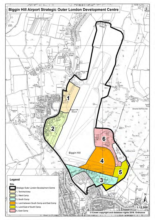
6.3.8 The policies relate both to the SOLDC generally and to specific land parcels within the SOLDC, which are identified in the following Map.
Map: Biggin Hill Strategic Outer London Development Centre (SOLDC)
| Policy 103 Biggin Hill SOLDC The Council will support the Biggin Hill SOLDC, including the provision of associated business infrastructure and amenities, as an important sub-regional hub for aviation and related high-tech industry, achieving sustainable economic growth whilst minimising adverse impacts on the environment and the amenity of surrounding communities. |
Supporting Text
6.3.9 The SOLDC status of Biggin Hill provides a strategic framework for economic growth at Biggin Hill Airport and the adjoining Biggin Hill LSIS, with a primary focus on aviation-related activities and associated business infrastructure and amenities. London Plan Policy 2.16 makes provision for bringing forward adequate development capacity, coordinating public and private investment and placing a strong emphasis on creating a distinct and attractive business offer. In considering development proposals in the SOLDC, the Council will have regard to the accessibility and environmental constraints of the SOLDC and surrounding areas.
6.3.10 The Council has been in active dialogue with key stakeholders to develop an updated policy setting for the SOLDC, including Biggin Hill Airport Limited, the stakeholder group LoCATE (London Centre for Aviation Technology and Enterprise), other landowners and relevant statutory authorities.
| Policy 104 Terminal Area Land in the Biggin Hill SOLDC identified as Terminal Area will be safeguarded for aviation-related employment generating uses. |
Supporting Text
6.3.11 The Terminal Area, including the existing control tower and terminal building, is the focus for passenger and goods handling and other ancillary facilities including distribution services, administrative offices, short and long–stay parking for cars, coaches and aircraft. The Terminal Area can potentially accommodate further intensification of aviation-related employment generating uses. The area to the north of the Terminal Area lies within the proposed SOLDC boundary but remains within the Green Belt to provide an adequate buffer between developed areas of the SOLDC and more open areas towards Leaves Green to the north.
| Policy 105 West Camp The Council will support the development of aviation-related employment generating uses on land in the Biggin Hill SOLDC identified as West Camp. Proposals for Class C1, D1, B1(a) and B1(b) uses in West Camp will be permitted if it can be demonstrated that the proposed uses:
|
Supporting Text
6.3.12 The privately owned West Camp comprises a range of former RAF buildings set in a campus-style layout, a large part of which falls within the RAF Biggin Hill Conservation Area. West Camp has airside access and is an appropriate location for airport-related development proposals.
6.3.13 The Council will adopt a flexible approach in considering potential land uses at West Camp that are not directly aviation related but can demonstrate consistency with the role of the SOLDC, as described in the Mayor’s Town Centres SPG.
| Policy 106 South Camp Sites providing existing airside access on land in the Biggin Hill SOLDC identified as South Camp will be safeguarded for aviation-related employment generating uses. Proposals for Class B2, B1(b), B1(c) and C1 uses will be permitted in South Camp if it can be demonstrated that the proposed uses:
The Council will not support any proposals in this identified area that would have an unacceptable adverse impact on land identified as a Site of Importance for Nature Conservation or on landscapes and residential areas in the vicinity of the SOLDC. |
Supporting Text
6.3.14 South Camp represents a key employment location at the Biggin Hill SOLDC and offers significant opportunity for aviation-related employment growth. The area provides the primary location for airport-related facilities and activities, including hangars, aircraft maintenance, aircraft parking and flying club facilities.
6.3.15 The Council will adopt a flexible approach in considering potential land uses at South Camp, such as industrial uses that are not directly aviation related but can demonstrate consistency with the role of the SOLDC, as described in the Mayor’s Town Centres SPG. Certain sections of South Camp have greater exposure to sensitive environments surrounding the SOLDC, including the adjoining SINC. The Council will consider whether proposals would result in unacceptable adverse impacts on these environments, in terms of structural design and operational aspects of the proposed land uses.
| Policy 107 Land East of South Camp Land in the Biggin Hill SOLDC identified as Land East of South Camp will be safeguarded for aviation-related employment generating uses. The Council will not support any proposals in this identified area that would have an unacceptable adverse impact on land identified as a Site of Importance for Nature Conservation or on landscapes and residential areas in the vicinity of the SOLDC. |
Supporting Text
6.3.16 This land parcel has been identified as important to the relocation of airport and aviation uses on the airside part of South Camp to enable their redevelopment to provide modern space for aviation related uses, in particular hangers and facilities for manufacturing uses including Original Equipment Manufacturers, and aircraft operators including Aircraft Operating Companies and Fixed Base Operators.
6.3.17 This location is not considered appropriate for non aviation-related development but could be used for replacement or relocated flying club buildings, aircraft parking and maintenance and similar aviation facilities. Certain sections of this land parcel have greater exposure to sensitive environments surrounding the SOLDC, including the adjoining SINC. The Council will consider whether proposals would result in unacceptable adverse impacts on these environments, in terms of structural design and operational aspects of the proposed land uses.
| Policy 108 East Camp Existing buildings in the Biggin Hill SOLDC area identified as East Camp will be safeguarded for aviation-related employment generating uses. The Council will not support any proposals in this identified area that would have an unacceptable adverse impact on land identified as a Site of Importance for Nature Conservation or on landscapes and residential areas in the vicinity of the SOLDC. |
Supporting Text
6.3.18 East Camp contains some existing hangars, storage and hard-standing areas and some redevelopment or refurbishment within this land parcel may be suitable in order to contribute to the development of the SOLDC. This location is not considered appropriate for non-aviation related development, but could be used for replacement or relocated flying club buildings, aircraft parking and maintenance, and similar aviation facilities.
6.3.19 Certain sections of this land parcel have greater exposure to sensitive environments surrounding the SOLDC, including the adjoining Cudham Lodge Woods and the broader SINC. Council will consider whether proposals would result in unacceptable adverse impacts on these environments, in terms of structural design and operational aspects of the proposed land uses.
General Policies for Biggin Hill SOLDC
| Policy 109 Airport Public Safety The Council will not grant planning permission for development likely to interfere with the safe and efficient operation of the Airport or Technical Site, in accordance with the Department for Transport Circular 1/2003, having particular regard to the safeguarded area, as shown on the Safeguarded Area Map. Within the Public Safety Zones, shown on the Public Safety Zones Map, there will be a general presumption against most kinds of new development and against certain changes of use and extensions to existing properties, as described in Department for Transport Circular 01/2010. |
Supporting Text
6.3.20 Public Safety Zones (PSZ) are areas of land extending outwards from the ends of the main runway where development is restricted. The basic policy objective governing the restriction on development is that there should be no increase in the number of people living, working or congregating in the PSZ. The Department for Transport Circular 01/2010: “Control of Development in Airport Public Safety Zones” contains specific guidance to enable the Council to determine applications affecting land within PSZs. Policies Map Set Part 1 includes a detailed map of the Biggin Hill Public Safety Zone.
6.3.21 A wider area around the Airport is safeguarded under Department for Transport Circular 1/2003: “Safeguarded Aerodromes, Technical Sites and Military Explosives Storage Areas”. The circular requires the outer boundary of the airport safeguarding area to be shown with the Local Plan and requires that certain planning applications will be subject of special consultation procedures to ensure that buildings, structures, or other works do not inhibit the operation and development of the Airport.
| Policy 110 Noise Sensitive Development in Biggin Hill Planning applications for new noise-sensitive development at, or in the vicinity of, Biggin Hill Airport will be assessed against the effect levels set out in the Noise Policy Statement for England. New noise sensitive development in areas likely to experience adverse impacts will be required to take steps to minimise and mitigate those effects as far as possible. Planning permission will not normally be granted where mitigation cannot prevent new development experiencing effects at or above the Significant Adverse Effects Level. |
Supporting Text
6.3.22 The impact of noise upon health and wellbeing is an important consideration for new development in and around airports. Aircraft noise can affect areas and noise-sensitive development under the flight path for some distance from the airport. The degree of disturbance is related to people’s perception of noise, the volume and character of noise, frequency of aircraft movements and other background noise.
6.3.23 Planning Practice Guidance sets out the noise exposure hierarchy which reflects the NPSE effect levels:
6.3.24 The UK Government considers that the equivalent continuous sound level of over 57dB(A) represents the noise level for the onset of community annoyance. For the purpose of assessing planning applications for new development in the area around Biggin Hill Airport, the 57dB(A) contour will be considered the starting point for requiring further investigation into the effects of airport-generated noise. Policies Map Set Part 1 includes a detailed map of the Biggin Hill Airbourne Aircraft Noise Contours.
6.3.25 For early morning flights night, i.e. prior to 07:00, research undertaken by the Department for Transport indicates that noise levels below the 90dB(A) SEL due to aircraft events are most unlikely to cause any measurable increase in the overall rates of sleep disturbances during normal sleep. For the purposes of development investigation will required for proposals lying additionally with the 90dB(A) SEL footprint but outside the 57dB(A) contour.
Planning Context
6.4.1 The London Plan (2016) Policy 2.16 identifies Crystal Palace as a potential Strategic Outer London Development Centre (SOLDC) with specialist strengths already functioning or with the potential to function above the sub-regional level and to generate growth above the Outer London trend without competing against existing town centres or other business locations.
6.4.2 The specialist strengths identified for the Crystal Palace SOLDC in Table 2.1 of the London Plan lie in its existing and potential leisure, tourism, arts, culture and sports functions. The park is also important for wildlife and biodiversity.
6.4.3 The potential of SOLDCs to develop and build on their specialist strengths is meant to be explored and taken forward through partnership working between the Mayor, Local Planning Authorities and other stakeholders.
Crystal Palace SOLDC Boundary
6.4.4 The Council has had discussions with neighbouring boroughs and with the Greater London Authority in late 2014 and early 2015 in relation to defining a boundary for the Crystal Palace SOLDC.
6.4.5 The boundary around the Crystal Palace Park reflects the location of the strategic assets of more than sub-regional importance which already generate or could potentially generate growth above the outer London trend within the Crystal Palace area.
6.4.6 The 'Crystal Palace SOLDC Local Plan Background Paper' provides background in relation to the identification of the boundary.
6.4.7 The Council acknowledges that the development potential of sites within the proposed SOLDC is constrained by the park's designation as Metropolitan Open Land and by the need to conserve and enhance the significance of its numerous heritage assets. Crystal Palace Park is highly accessible with five train and overground stations within walking distance. The Grade II* listed historic Metropolitan Park is on the national register of Historic Parks and Gardens and has particular historic and cultural significance as the former site of Joseph Paxton’s Crystal Palace. It includes nationally and regionally important assets including the Grade II* National Sports Centre, the remaining listed terraces and sphinxes from the Crystal Palace and the Grade I listed prehistoric Victorian sculptures of monsters and dinosaurs. The whole park is designated as a Conservation Area.
6.4.8 In 2011, a Masterplan submitted by the London Development Agency (LDA), folded into the Greater London Authority in 2012, was granted outline permission for the duration of 15 years. The Masterplan seeks to restore and improve the park and reinstate its national and international status. The park represents opportunities to encourage growth of more than sub-regional importance beyond its boundaries particularly through visitor spend in Crystal Palace and other neighbouring town centres within the Crystal Palace, Penge and Anerley Renewal Area. The delivery of key capital projects is already underway, such as that of the restoration of the Dinosaurs. The GLA has also been considering options for elements of development and redevelopment on the site of the National Sports Centre.
Map: Crystal Palace Strategic Outer London Development Centre (SOLDC)
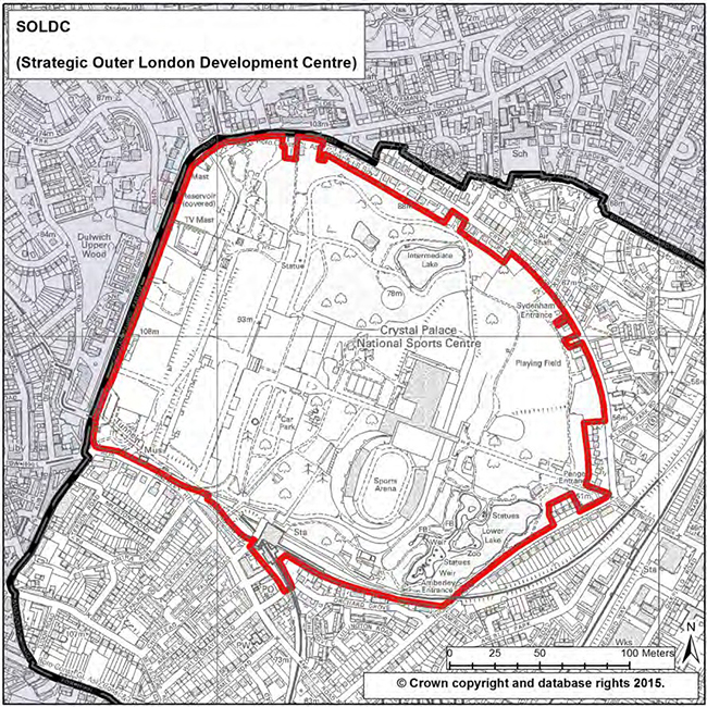
| Policy 111 Crystal Palace Strategic Outer London Development Centre The Council will expect any proposals for the Crystal Palace Strategic Outer London Development Centre (SOLDC), as defined on the policies map, to maintain, enhance and support the unique existing strategic cultural, sports, tourism and leisure functions of the Crystal Palace Park. Any development proposals will be subject to other policies within the Local Plan, notably Metropolitan Open Land policies and guidance related to the Crystal Palace Park Conservation Area and will be required to be consistent with the objectives identified as part of the approved masterplan for the park. They will be expected to contribute to and/or strengthen as appropriate the sub-regional importance of the SOLDC having regard to its specialist identified strengths whilst maintaining and improving the park’s open setting and the visual and landscaping amenities which inform its character and that of the key heritage assets within its boundaries. The Council will work with the Mayor, the community and other stakeholders to ensure that development proposals and other initiatives within the SOLDC contribute to the long term planning and regeneration strategies for the park and support where appropriate the wider Crystal Palace, Penge and Anerley Renewal Area objectives. |
Supporting Text
6.4.9 The London Plan identifies Crystal Palace as a potential Strategic Outer London Development Centre with specialist economic functions of more than sub-regional importance related to leisure, tourism, arts, culture and sports. The SOLDC’s key strengths are underpinned by the presence of the National Sports Centre within the park and the historic and cultural significance of the park itself which draws visitors from London and beyond. The park shares its boundary with the London Boroughs of Lambeth, Croydon, Lewisham and Southwark for which it is also of strategic significance.
6.4.10 The Crystal Palace Park was created in 1852-55 by Sir Joseph Paxton’s Crystal Palace Company to provide a new home for the enlarged Crystal Palace, which, in its original form originally housed the Great Exhibition in 1851 in Hyde Park. The park also included elaborate landscape as well as water and fountain works designed by Sir Joseph Paxton.
6.4.11 The park and the palace became an international paying attraction until the palace was destroyed by a fire in 1936 although some of the now Grade II Listed terraces and ornamental sphinxes remain. The park still includes Dinosaur Island, a collection of over 30 statues created by Benjamin Waterhouse Hawkins in the 1850s set within a model geological landscape. The sculptures’ Grade I listing recognises their international significance as these were designed to reflect contemporary scientific advances whilst the model geological landscape’s proposed designation as a Regionally Important Geological Site (RIG) reflects its regional significance. The Green Chain walk goes through Crystal Palace Park, joining up sections in Southwark and Bromley.
6.4.12 The Crystal Palace Park saw significant change from the 1930s culminating in the 1960s with the completion of the National Sports Centre and Athletics Stadium conceived as a unique “sports park” which partially obscures the park’s original walkway axis. The Grade II* Listed centre is a historically significant sports and leisure facility which is used to host national and international sporting events and has been used to host Olympic training events.
6.4.13 A masterplan submitted by the London Development Agency (now the GLA) was granted outline permission in 2011, establishing key development principles for the Park. These include a number of environmental improvements to restore the former character of the park, improvements to the National Sports Centre and the building, improvements and redevelopment of some key facilities. The vision behind the masterplan is to reinstate the local, regional and international significance of the park including by promoting it as a primary visitor attraction. The Council is currently investigating options to deliver some of the masterplan’s proposals through a sustainable Development Strategy. The Council will work to ensure that proposals support the sub-regional role of the SOLDC having regards to its identified specific strengths.
6.4.14 The Greater London Authority has been investigating options for the possible refurbishment, enhancement and part redevelopment of the National Sports Centre site which it leases from the London Borough of Bromley. The Council will work with the Mayor of London, Historic England, and with other stakeholders to identify adequate development capacity and ensure it supports the SOLDC designation should any development opportunities come forward.
6.4.15 Whilst significant at a sub-regional level, the development capacity of the park faces major constraints. The entire park is designated as Metropolitan Open Land (MOL) and there are significant areas designated as a Borough Grade I Site of Importance for Nature Conservation. Most of the park is also a Conservation Area managed through adopted Supplementary Planning Guidance (SPG), reflecting the historic significance of the park and the setting it provides to the Parkside residences built from the mid to the end of 19th century on Crystal Palace Road, Thicket Road and Anerley Hill. It is important that any development proposals taking place within the park’s setting are in line with the Crystal Palace Park Conservation SPG and MOL designation objectives, respect the nature conservation value of the site and are in accordance with the objectives identified as part of the approved masterplan for the park. The park itself is a Grade II* Listed park on Historic England's Register of Historic Parks and Gardens which includes a large number of significant assets including the Grade II* Listed National Sports Centre, the Grade II* Listed upper and lower terraces of the Crystal Palace Gardens, the lower level of Crystal Palace Station, the bust of Sir Joseph Paxton, the gatepiers to Rockhill, the Royal Navy Volunteer Reserve Trophy War Memorial and the Grade I prehistoric animal sculptures and geological formations by the lake.
6.4.16 Crystal Palace Park lies within the Crystal Palace, Penge and Anerley Renewal Area. Policy 15 seeks to maximise the opportunities for proposals presented by the Crystal Palace SOLDC so that they contribute and benefit from the thriving cultural and leisure economy of Crystal Palace’s District Centre, and enhance as well as capture broader benefits for Penge District Centre, and the more local Anerley centre. The Council will work with stakeholders to seek to ensure complementarity between major development proposals and initiatives within the SOLDC and other proposals within the renewal area and the wider area of influence of the park where justified in strategic planning terms. The London Plan (2.63A) states that the overriding objective of the Mayor's regeneration programmes is to drive and shape growth in town and economic centres and high streets. The relationship of the Park to the larger renewal area offers broad economic, environmental and social benefits.
< Previous | ^ Top | Next >