
| Sites of 9 units | Status | Site size | Site Area (ha) | Years 1-5 15/16 -19/20 |
Years 06-10 20/21 -24/25 |
Years 11-15 25/16-29/30 |
Totals |
|---|---|---|---|---|---|---|---|
| Bickley Ward | |||||||
| Gas Holder Site Homesdale Road/Liddon Road | CFS | Large | 1 | 60 | 60 | ||
| Land adjacent to Bickley Station | CFS | Large | 0.9 | 30 | 30 | ||
| Homesdale Centre 216 - 218 Homesdale Road BR1 2QZ | S | Small | 0.012 | 6 | 6 | ||
| Biggin Hill Ward | |||||||
| 20-22 Main Road Biggin Hill TN16 3EB | S | Large | 0.4 | 9 | 9 | ||
| Church Road Biggin Hill (1-9) TN16 3LB | P | Large | 0.3 | 27 | 27 | ||
| Land between Main Road Vincent Square Barwell Crescent and Moxey Close Biggin Hill TN16 3GD and Moxey Close Biggin Hill TN16 3GD |
P | Large | 0.7 | 16 | 16 | ||
| Bromley Common and Keston | |||||||
| Blue Circle Sports Ground Crown Lane Bromley BR2 9PQ | S | Large | 12 | 22 | 22 | ||
| Bromley Common Liveries Cameron Buildings Bromley BR2 8HA | P | Large | 2.9 | 9 | 9 | ||
| Bromley Town | |||||||
| Title House 33-35 Elmfield Road BR1 1LT | S | Small | 0.19 | 50 | 50 | ||
| Land at South Side of Ringers Road BR1 1HP | S | Large | 0.27 | 34 | 34 | ||
| 165 Masons Hill BR2 9HW | P | Small | 0.13 | 23 | 23 | ||
| H G Wells Centre St Marks Road Bromley BR2 9HG | P | Small | 52 | 52 | |||
| Site B Tweedy Road/London Road | BTCAAP | Large | 0.37 | 24 | 24 | ||
| Site C Old Town Hall Tweedy Rd | P | Large | 0.7 | 53 | 53 | ||
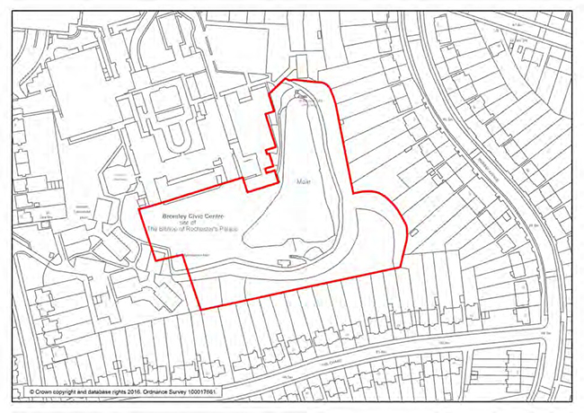
| Site F Bromley Civic Centre Stockwell Close | BTCAAP | Large | 5.75 | 70 | 70 | ||
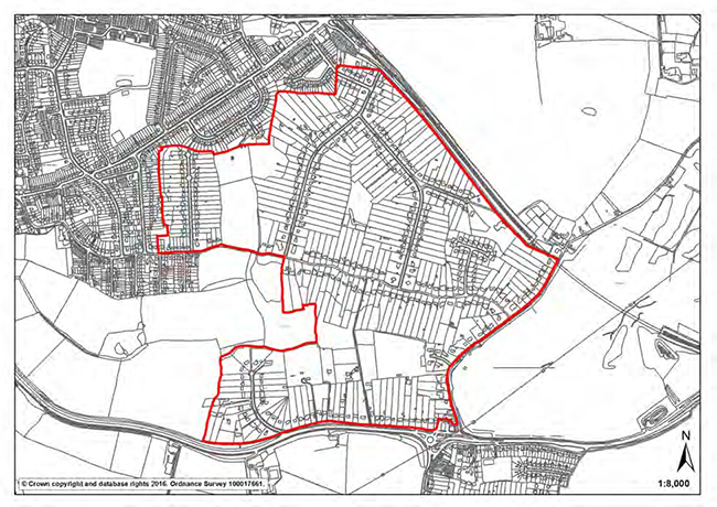
| West of High Street and Bromley South | BTCAAP/HZ | Large | 310 | 920 | 1230 | ||
| Site K Westmoreland Road Car Park Simpons Road | S | Large | 0.96 | 200 | 200 | ||
| Site P Sainsburys West Street | BTCAAP | Large | 1.25 | 20 | 20 | ||
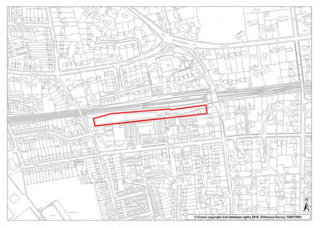
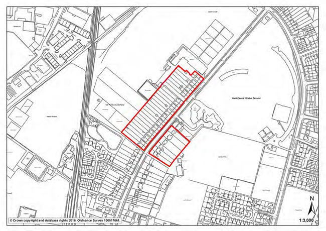
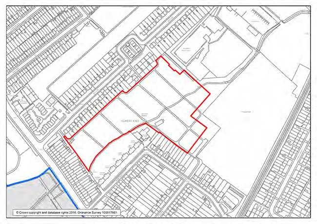
| Land adj to Bromley North Station | CFS | Large | 2.86 | 440 | 85 | 525 | |
| Broadway House High Street BR1 1LF | S | Small | 0.08 | 43 | 43 | ||
| Crosby House Elmfield Road BR1 1LT | S | Small | 0.2 | 22 | 22 | ||
| Oxford House 11 London Road BR1 1BY | S | Small | 0.06 | 17 | 17 | ||
| Waterford House 4 Newman Road BR1 1RJ | S | Small | 0.04 | 14 | 14 | ||
| The Hill Car Park and adjacent land | CFS/HZ | Large | 150 | 150 | |||
| Chislehurst | |||||||
| Banbury House, Bushell Way, Chislehurst BR7 6SF | CFS | Large | 0.27 | 25 | 25 | ||
| Clock House | |||||||
| County House 221-241 Beckenham Road BR3 4UF | S | Small | 0.12 | 75 | 75 | ||
| Copers Cope | |||||||
| Dylon International Ltd Worsley Bridge Road SE26 5HD | S | Large | 0.28 | 74 | 74 | ||
| Dylon International Ltd Worsley Bridge Road SE26 5HD | S | Large | 0.28 | 149 | 149 | ||
| 57 Albemarle Road BR3 5HL | S | Small | 0.16 | 14 | 14 | ||
| Cray Valley West | |||||||
| Grays Farm Production Village, Grays Farm Road | S | Large | 1.09 | 45 | 45 | ||
| Grays Farm Production Village (Care Home units) | P | Large | 0.4 | 75 | 75 | ||
| Bromley Valley Gym and adjacent land Chipperfield Road St Mary Cray | CFS | Large | 2.8 | 200 | 200 | ||
| Crystal Palace | |||||||
| 193 Anerley Road Penge SE20 8EL | S | Small | 0.13 | 9 | 9 | ||
| The Haven Springfield Road SE26 6HG | P | Large | 1.4 | 46 | 46 | ||
| Orchard Lodge William Booth Road Anerley London SE20 | CFS | Large | 200 | 50 | 250 | ||
| Crystal Palace Park Crystal Palace Park Road SE20 | P | Large | 1.9 | 180 | 180 | ||
| Farnborough and Crofton | |||||||
| Small Halls, York Rise, Orpington | CFS | Large | 0.46 | 35 | 35 | ||
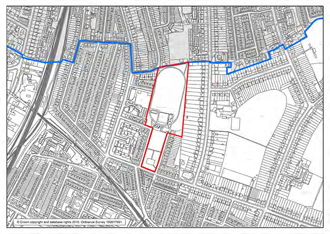
| Bassetts Campus Broadwater Gardens BR6 7UZ | CFS | Large | 2.5 | 40 | 75 | 115 | |
| Hayes and Coney Hall | |||||||
| 1 Chilham Way BR2 7PR | S | Large | 0.78 | 14 | 14 | ||
| Isard House Glebe House Drive Hayes | S | Large | 0.57 | 21 | 21 | ||
| Hayes Court West Common Road BR2 7AU | S | Large | 2.6 | 17 | 17 | ||
| All Saints Catholic School Layhams Road West Wickham BR4 9HN | P | Large | 2.3 | 48 | 48 | ||
| Kelsey and Eden Park | |||||||
| Langley Court, South Eden Park Road BR3 3AT | P | Large | 10.6 | 179 | 179 | ||
| The Rising Sun, Upper Elmers End Road BR3 3DY | S | Large | 0.18 | 16 | 16 | ||
| Orpington | |||||||
| Farnborough and Crofton | CFS | Large | 0.3 | 28 | 28 | ||
| Orpington Police Station The Walnuts BR6 0TW | S | Small | 0.2 | 83 | 83 | ||
| Berwick House 8-10 Knoll Rise BR6 0EL | S | Small | 0.1 | 88 | 88 | ||
| 155-159 High Street BR6 0LN | P | Small | 0.1 | 9 | 9 | ||
| Homefield Rise Orpington BR6 (No's 18-44) | CFS | 44 | 43 | 87 | |||
| Penge and Cator | |||||||
| Oakfield Centre Oakfield Road SE20 8QA | S | Large | 0.3 | 24 | 24 | ||
| Petts Wood and Knoll | |||||||
| Mega House Crest View Drive BR5 1BY | S | Large | 0.3 | 29 | 29 | ||
| Plaistow and Sundridge | |||||||
| Sundridge Park Management Centre Ltd Plaistow Lane Bromley BR1 3JW | S | Large | 2.27 | 28 | 28 | ||
| Holy Trinity Convent School Plaistow Lane BR1 3LL | S | Large | 0.95 | 22 | 22 | ||
| 25 Scotts Road BR1 3QD | S | Large | 0.4 | 38 | 38 | ||
| West Wickham | |||||||
| Summit House Glebe Way BR4 0RJ | S | Large | 0.5 | 54 | 54 | ||
| BROAD LOCATIONS Bromley Town Centre (250) Orpington (125) Changing retail patterns (290) Public Land Reorganisation (300) |
Large | 390 | 575 | 965 | |||
| Sites of 9+ units total | 2034 | 2134 | 1580 | 5748 | |||
| 20 Completions to date | 670 | 0 | 0 | 670 | |||
| Small sites started (1-8 units) | 76 | 19 | 0 | 95 | |||
| Small sites projection | 626 | 1320 | 1706 | 3652 | |||
| Vacant units projection | 80 | 100 | 100 | 280 | |||
| Prior approval projection | 200 | 0 | 0 | 200 | |||
| TRAJECTORY TOTAL | 3686 | 3573 | 3386 | 10645 | |||
| Cumulative completions | 3686 | 7259 | 10645 | ||||
| London Plan targets | 3205 | 3205 | 3205 | ||||
| Cumulative strategic allocation | 3205 | 6410 | 9615 | ||||
| Difference between cumulative trajectory and London Plan Targets | 481 | 849 | 1030 | ||||
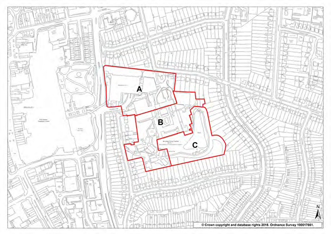
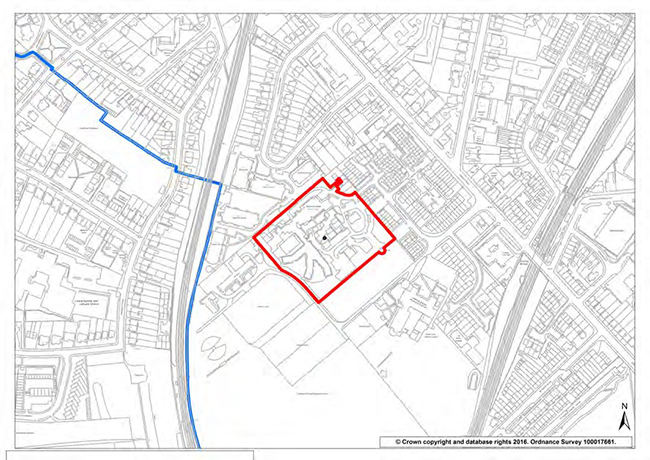
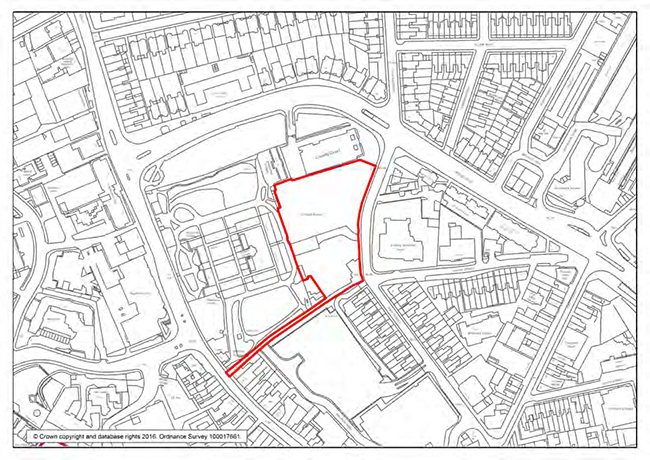
| Site 1: | Bromley Civic Centre, Stockwell Close |
| Site area: |
5.93 ha |
| Site policy: | Partial redevelopment of the northern section (A) for civic centre facilities, offices and related activities. Retention of North Block, the Stockwell Building and the multi-storey car park. Development of the central section (B) for around 70 residential units, including the sensitive reuse of the Grade II listed Old Palace. Retention of the south eastern section (C) as a public park. Proposals will be expected to retain public access across the site from Stockwell Close and Rafford Way and to minimise impacts on the Urban Open Space (Local Green Space), Site of Importance for Nature Conservation, and listed buildings. |
| Local Plan phasing: | Years 6-10 |
| Site area: | 5.93 ha |
| Current status: | The Council’s Executive 18th May 2016 resolved to appropriate part of the site for a public park, part for a new democratic hub and disposal of part of the site subject to planning. |
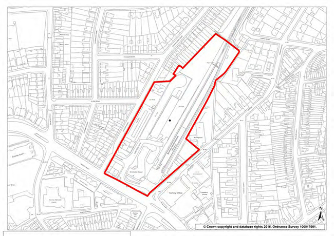
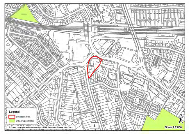
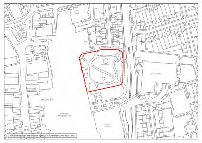
| Site 2: | Land adjacent to Bromley North Station |
| Site area: |
3 ha |
| Site policy: | Redevelopment for mixed use including 525 residential units, 2000 sqm of office accommodation, space for community use, 230 sqm café/retail, transport interchange and parking. Proposals will be expected to:
|
| Local Plan phasing: | Years 6-10 and 11-15 |
| Site area: | 3 ha |
| Current status: | Included in Bromley Town Centre Housing Zone bid |
| Site 3: | Hill Car Park and Adjacent Lands, Bromley Town Centre |
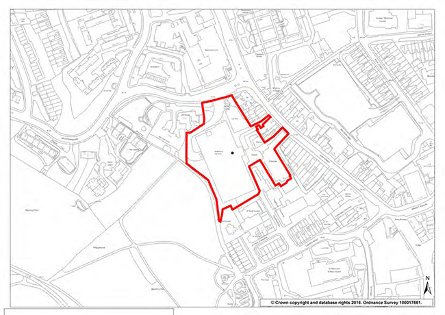
| Site area: | 1.25 ha |
| Site policy: | Development for mixed use including retail (150sqm), cultural facilities, car parking for the public and for residential, and 150 residential units. Proposals will be expected to:
|
| Local Plan phasing: | Years 6-10 |
| Site area: | 1.25 ha |
| Current status: | Included in Bromley Town Centre Housing Zone bid |
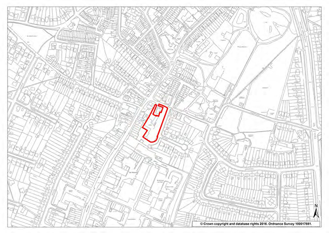
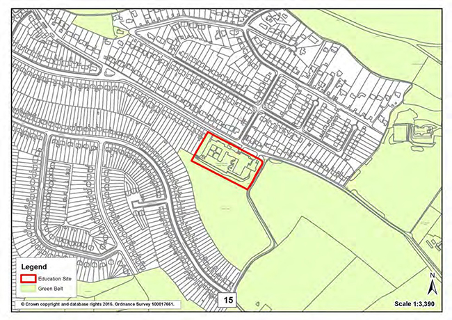
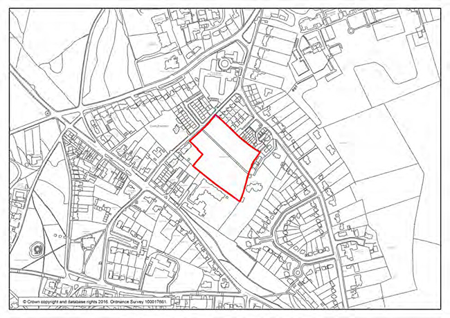
| Site 4: | Gas Holder site, Homesdale Road, Bickley |
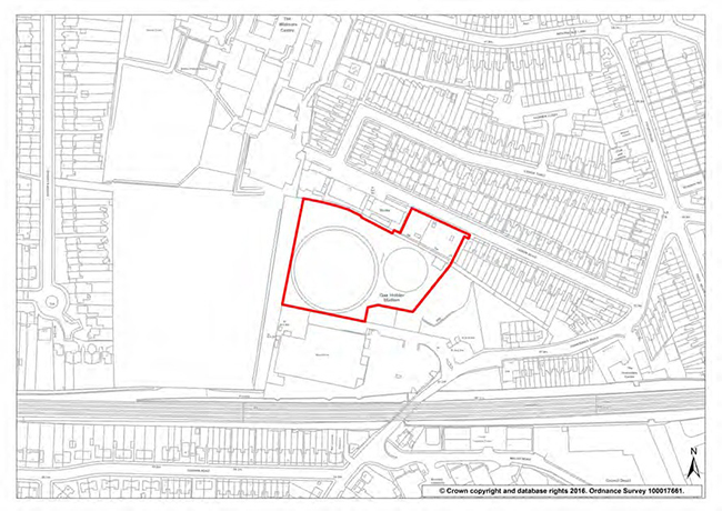
| Site area: |
1 ha |
| Site policy: | Redevelopment for mixed use including 60 residential units. Proposals will be expected to:
|
| Local Plan phasing: | Years 6-10 |
| Current status: | Gas holders no longer in use. |
| Site 5 | Land adjacent to Bickley Station |
| Site area: |
0.85 ha |
| Site policy: | Redevelopment for around 30 residential units. Proposals will be expected to:
|
| Local Plan phasing: | Years 6-10 |
| Current status: | Network rail operational uses and scaffolding storage/ distribution yard. |
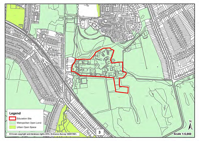
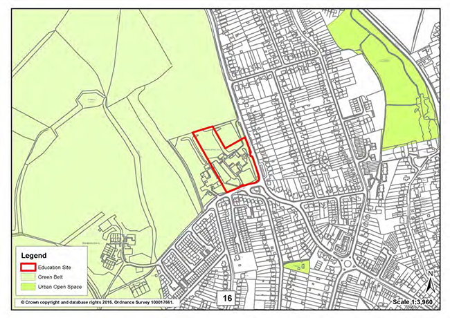
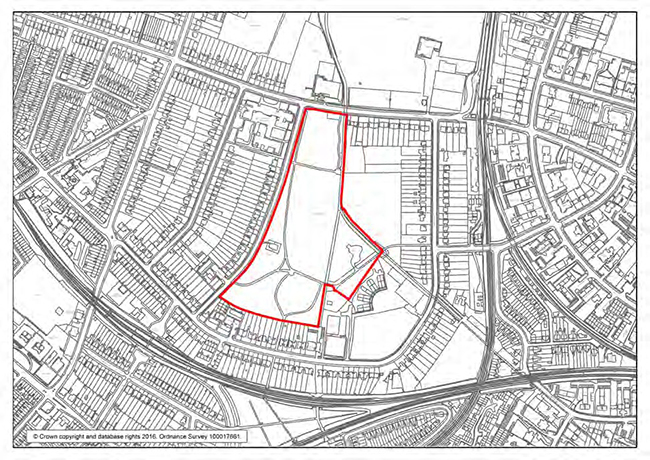
| Site 6: | Bromley Valley Gym and Adjacent Lands, Chipperfield Road, St Paul’s Cray |
| Site area: |
2.8 ha |
| Site policy: | Development for mixed use including the re-provision of St Paul Cray library, community uses, the Bromley Valley Gym facilities (a gymnastics centre) and around 200 residential units. Proposals will be expected to:
|
| Local Plan phasing: | Years 6-10 |
| Site area: | 2.8 ha |
| Current status: | Bromley Valley Gym, St Paul's Cray library, car parking, linear park. |
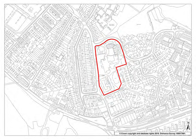
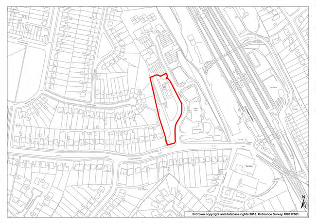
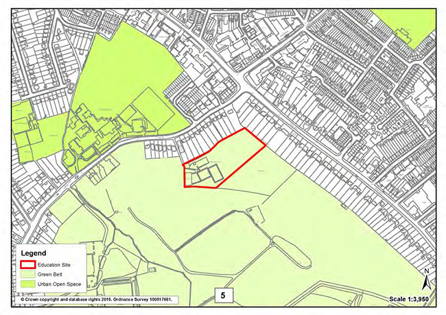
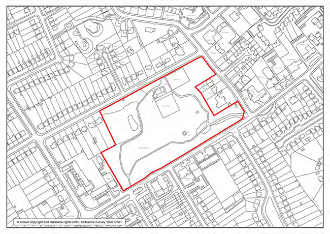
| Site 7: | Orchard Lodge, William Booth Road, Penge |
| Site area: |
1.8 ha |
| Site policy: | Redevelopment for around 250 residential units. Proposals will be expected to:
|
| Local Plan phasing: | Years 1-5 and 6-10 |
| Current status: | Vacant buildings and hardstanding. Planning permission granted under 16/02117/FULL1 for 252 residential units. |
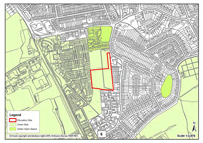
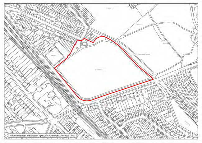
| Site 8: | Bassetts Campus, Broadwater Gardens, Orpington |
| Site area: |
2.6 ha |
| Site policy: | Redevelopment for around 100 residential units including conversion of Bassett’s House. Proposals will be expected to:
|
| Local Plan phasing: | Years 1-5 and 6-10 |
| Site area: | 2.6 ha |
| Current status: | Planning permission granted under 15/04941/FULL3 subject to legal agreement for conversion of Bassett’s House to 13 flats and the development of 102 residential units. |
| Site 9: | Former depot, Bruce Grove, Orpington |
| Site area: |
0.36 ha |
| Site policy: | Redevelopment for around 30 residential units. Proposals will be expected to: Respect and complement The Priory Conservation Area and adjacent listed building Mitigate flood risk Minimise adverse impacts on the amenities of the neighbouring residential street. |
| Local Plan phasing: | Years 1-5 |
| Current status: | Vacant site. Planning permission was granted under 15/04574/FULL1, subject to legal agreement, for residential development of 28 units. |
| Site 10: | West of Bromley High Street and land at Bromley South |
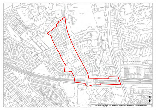
| Site area: |
4.54 hectares |
| Site policy: | Redevelopment for mixed use including 1230 residential units, offices, retail and transport interchange. Proposals will be expected to:
|
| Site area: | 4.54 hectares |
|
|
| Local Plan phasing: | Years 6-10 and 11-15 |
| Current status: | Partly coincides with Site G in the Bromley Town Centre Area Action Plan. Included in Bromley Town Centre Housing Zone bid. |
| Site 11: | Homefield Rise, Orpington |
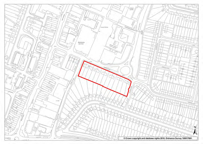
| Site area: |
0.75 ha |
| Site policy: | Redevelopment of 18-44 Homefield Rise for around 100 residential units. Proposals will be required to: Create an effective transition between the adjacent town centre and lower rise residential area Respect the amenity of adjoining residential properties |
| Local Plan phasing: | Years 1-5 and 6-10 |
| Current status: | 13 residential properties |
| Site 12: | Small Halls, York Rise, Orpington |
| Site area: |
0.46 ha |
| Site policy: | Redevelopment for around 35 residential units. Proposals will be expected to respect the amenity of adjoining residential properties. |
| Local Plan phasing: | Years 1-5 |
| Current status: | Vacant. Temporary approval for use as a car park. |
| Site 13 | Banbury House, Bushell Way, Chislehurst |
| Site area: |
0.27 ha |
| Site policy: | Redevelopment for around 25 residential units. Proposals will be expected to respect the amenity of adjoining residential properties. . |
| Local Plan phasing: | Years 1-5 |
| Current status: | Vacant building. |
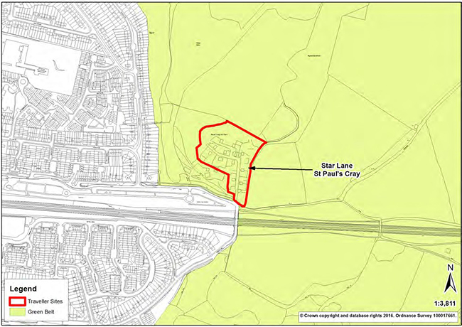
| Site 14: | Star Lane |
22 pitch Gypsy and Traveller council site with planning permission.
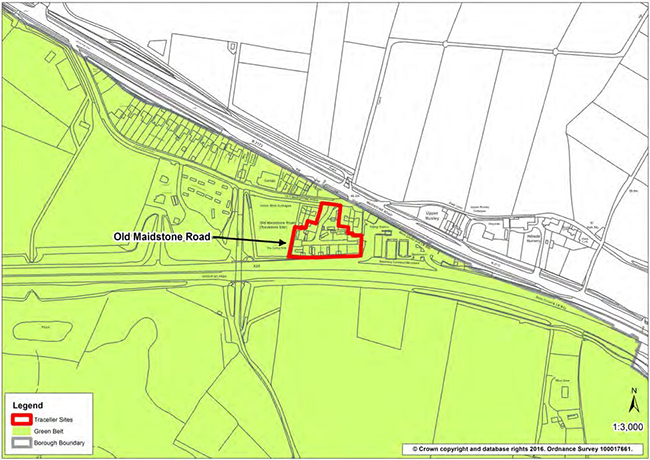
| Site 15: | Old Maidstone Road |
14 pitch Gypsy and Traveller council site with planning permission.
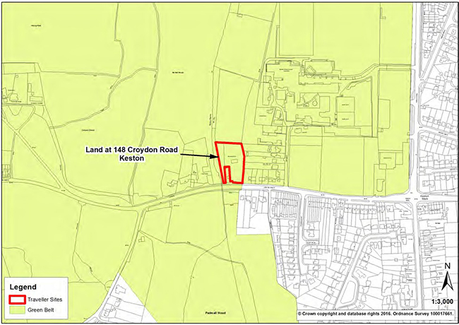
| Site 16: | 148 Croydon Road |
5 pitch Gypsy and Traveller private site with planning permission.
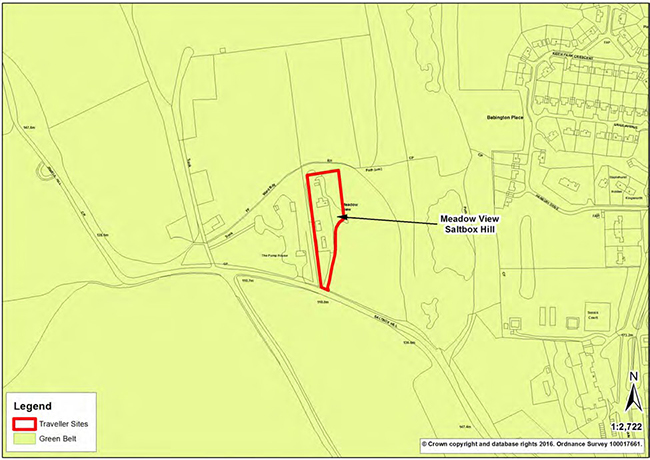
| Site 17: | Meadow View, Saltbox Hill |
Gypsy and Traveller private site with Certificate of Lawfulness.
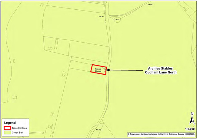
| Site 18: | Archie's Stables, Cudham Lane North |
Single pitch Gypsy and Traveller private site with planning permission.
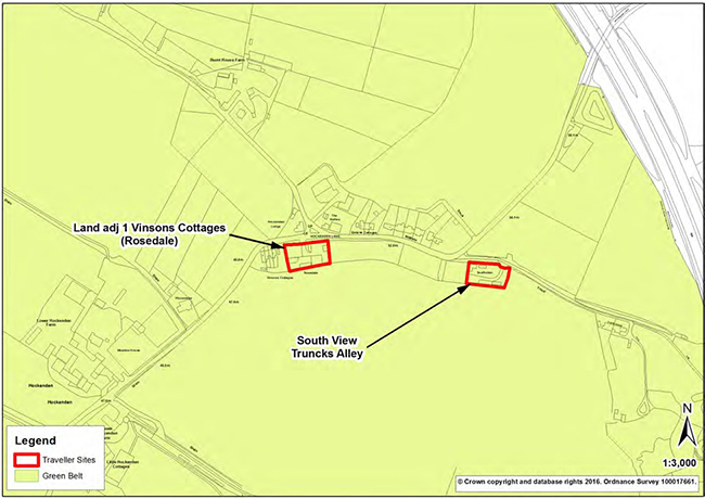
| Site 19: | Rosedale, Hockenden Lane |
Single pitch Gypsy and Traveller private site with planning permission.
| Site 20: | Southview, Trunks Alley, Hockenden Lane |
2 pitch Gypsy and Traveller private site with planning permission.
| Site 21: | Mead Green, Layhams Road |
Historic 2 pitch Gypsy and Traveller private site, no current planning permission.
| Site 22: | St Joseph's Place, Layhams Road |
Historic 2 pitch Gypsy and Traveller private site, no current planning permission.
| Site 23: | Millie's View, Layhams Road |
Historic 2 pitch Gypsy and Traveller private site, no current planning permission.
| Site 24: | Keston Mobile Park, Layhams Road |
Historic 4 pitch Gypsy and Traveller private site, no current planning permission.
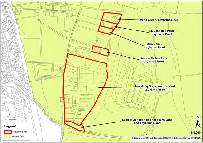
| Site 25: | Keston Travelling Showmen's Ground, Layhams Road |
29 plot Travelling Showmen's private site (yard) with planning permission.
| Site 26: | Land at junction with Sheepbarn Lane, Layhams Road |
| 2 plot Travelling Showmen's private site (yard) with temporary planning permission. | |
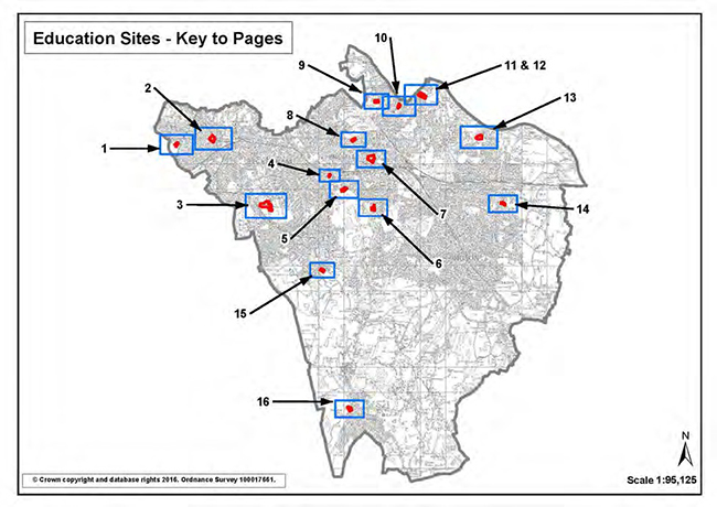
Key to Education Site Allocations Maps
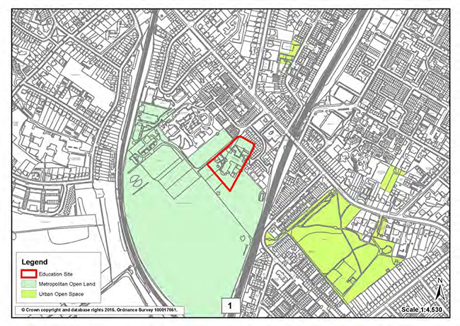
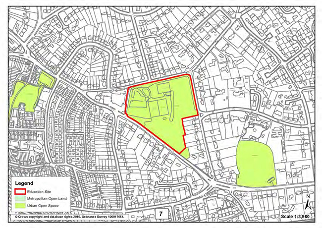
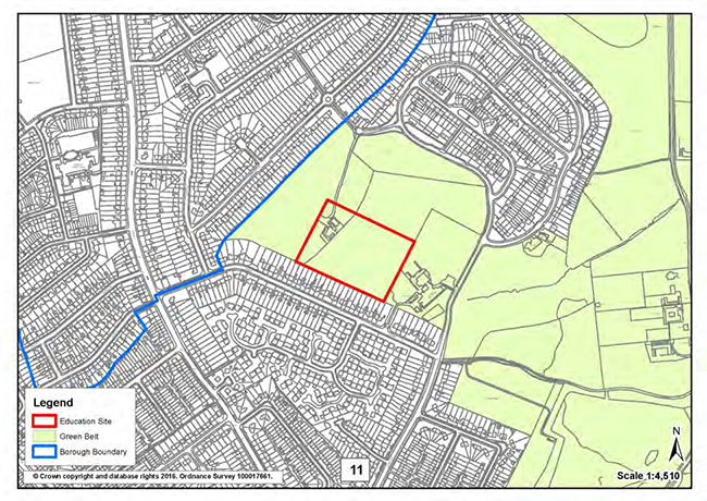
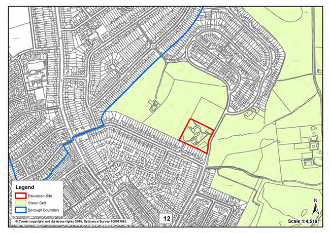
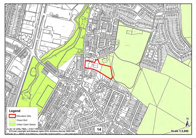
| Site 27: | James Dixon Primary School, William Booth Road |
Re-designate this Metropolitan Open Land (MOL) fringe site from MOL to Urban Open Space to facilitate educational expansion opportunities to meet identified need during the plan period.
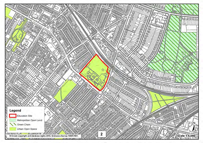
| Site 28: | Kentwood Site, High St. Penge (including Adult Education Centre and Harris Primary Academy Kent House) |
Allocate for expanded provision, potentially facilitating up to 4FE of secondary education.
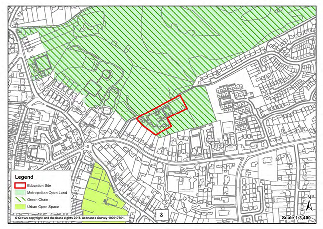
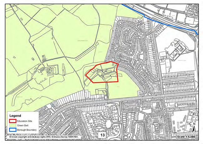
| Site 29: | Langley Park School for Boys and Langley Park School for Girls, Hawksbrook Lane. |
Re-designate the two schools complex from Metropolitan Open Land to Urban Open Space and allocate for additional primary school (Langley Park Free School).
| Site 30: | 1 Westmoreland Road |
Allocate, in whole or in part, for education use.
| Site 31: | Bromley Education Trust, Hayes Lane |
Re-designate this Green Belt fringe site from Green Belt to Urban Open Space and allocate for additional primary or secondary school during the local plan period.
| Site 32: | Turpington Lane, Bromley Common |
Re-designate this isolated Green Belt site from Green Belt to Urban Open Space and allocate for additional secondary school within part of the site during the local plan period. Note allotments to the north of the site, outside the area allocated for education to be designated as Local Green Space (Appendix 10.8 site no.65).
| Site 33: | St. Hugh's Playing Field, Bickley Road |
Allocate this Urban Open Space site, owned by Bullers Wood School for Girls, for an additional secondary school (Bullers Wood School for Boys).
| Site 34: | Scotts Park Primary School, Orchard Road |
Re-designate this Metropolitan Open Land (MOL) fringe site from MOL to Urban Open Space to facilitate educational expansion opportunities to meet identified need during the plan period.
| Site 35: | Castlecombe Primary School and Youth Centre, Castlecombe Road |
Re-designate this Metropolitan Open Land (MOL) fringe site from MOL to Urban Open Space to facilitate educational expansion opportunities to meet identified need during the plan period.
| Site 36: | Land at Bushell Way, Chislehurst |
Allocate this Urban Open Space (UOS) site for primary education (relocated Chislehurst, St Nicholas or different primary provider). Note adjacent UOS to be designated as Local Green Space (Appendix 7 site no.6).
| Site 37: | Land adjacent to Edgebury Primary School, Slades Drive |
Re-designate this Green Belt fringe site from Green Belt to Urban Open Space and allocate the site, which has a covenant for education use, for an additional secondary school during the local plan period.
| Site 38: | Edgebury Primary School |
Re-designate this Green Belt fringe site from Green Belt to Urban Open Space to facilitate educational expansion opportunities to meet identified need during the plan period.
| Site 39: | Midfield Site, Midfield Way (including primary school and alternative provision) |
Re-designate this Green Belt fringe site from Green Belt to Urban Open Space and allocate for additional education development within the site during the local plan period.
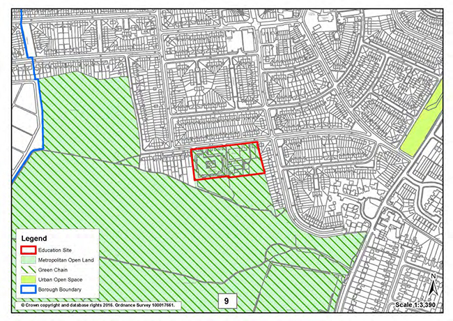
| Site 40: | St Mary Cray Primary School, High St. St Mary Cray |
Re-designate the area of Green Belt within this site from Green Belt to Urban Open Space and allocate for additional education development within the site during the local plan period
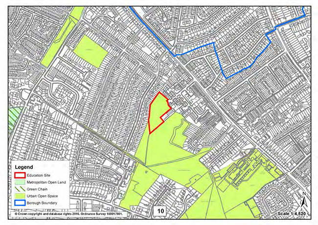
| Site 41: | Wickham Common Primary School, Gates Green Road |
Re-designate this Green Belt fringe site from Green Belt to Urban Open Space to facilitate educational expansion opportunities to meet identified need during the plan period.
| Site 42: | Oaklands Primary, Norheads Lane |
Re-designate this Green Belt fringe site from Green Belt to Urban Open Space to facilitate educational expansion opportunities to meet identified need during the plan period.
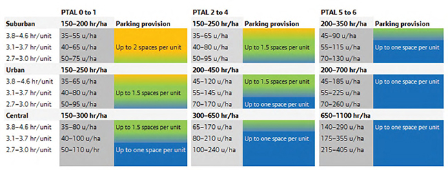
London Plan Residential Parking Standards
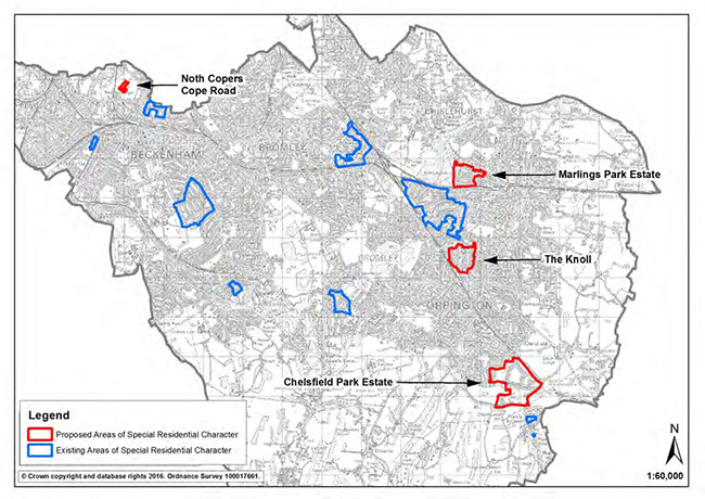
Areas of Special Residential Character
The following areas, displayed on Map 1, are carried forward from the UDP as designated ASRCs in the Local Plan. They are shown on the Policies Map set Part 1.
A description of these areas is included in Section 1 . The description of the Petts Wood ASRC has been amended from the UDP.
The following areas, displayed on maps included in the text below, are proposed to be designated as ASRCs in the Local Plan.
Detailed boundaries and descriptions for these areas are included in Section 2.
Guidelines for ASRCs are included in Section 3.
Map 1. Existing and Proposed ASRCs
Section 1. Descriptions of Areas of Special Residential Character carried forward fromtheUDP
1. Park Langley - The original Edwardian core of the Park Langley "garden suburb" is a Conservation Area. The remainder, built sporadically between the 1920's and 1950's, whilst not of the same exceptional standard, has the character of a garden estate given by the quality and appearance of the hedges, walls, fences, and front gardens. The area, which comprises almost exclusively large detached two storey family houses on generous plots, is bounded by Wickham Way to the west, by Barnfield Wood Road to the south, and by Hayes Lane to the north and east. It represents a coherent, continuous and easily identifiable area, which has maintained its character and unity intact.
2. Beckenham Place Park, Foxgrove Avenue & Foxgrove Road (part) -
Beckenham Place Park is a private road with a mixed character and may be considered to fall into two parts:
(i) The western end, a pleasant residential area comprising some post-war as well as substantial inter-war detached family houses of no particular architectural merit, but in a good setting with the statutorily listed lodges to Beckenham Place Park at the entrance from Southend Road.
(ii) The eastern end, where one of the original large Victorian Houses, St. Margaret's, survives amongst dense tree planting, together with more modern developments.
The adjacent open spaces and fine street trees provide most of the area's character of remoteness. Trees within the grounds of St Margaret's, are covered by a Tree Preservation Order. Two other Victorian houses on the north side of the road are included within the Beckenham Place Park Conservation Area (designated August 1993).
In the case of Foxgrove Avenue and Foxgrove Road, the properties are in the main inter/post-war and present a less expansive impression than other parts of this area. The rear gardens are spacious and in most cases provide an important and attractive backdrop to the surrounding open space.
3. Petts Wood – The area includes circa 1500 dwellings within detached and semi-detached properties on circa 112 ha of land. It is bounded by the railway to the north, Chislehurst Road Conservation Area to the north east, tree preservation orders and the railway to the north west and the west (excluding Urban Open Space, properties within Petts Wood Station Square Conservation area and other areas which include retail and carparking uses), part of St John’s Road to the south west, the Chenies Conservation Area and residential areas considered to be of distinct character and/or standard to the south and west of Crofton Lane and east of Grosvenor Road.
The original plans for Petts Wood date from the late 1920s and the early 1930s. Whilst there have been some changes post war the prevailing design of the buildings is from the 1930s and remains largely intact. Some of the properties have been built by the distinguished designer Noel Rees who designed all of the building within the neighbouring Chenies Conservation area. Whilst houses were built over a number of years, in a number of similar though varied styles, the road layout and plot sizes were established in an overall pattern, following the garden suburb principle which largely remains intact today. The large plots which are spaciously placed were originally designed following the garden suburb principle by developer Basil Scruby. The regularity of front building and rear building lines, the consistency in the front roof lines largely untouched by roof extensions or conversions and the symmetry between pairs and neighbouring pairs of houses are of importance in defining the character of the area. The Petts Wood ASRC has an open, suburban and semi-rural feel, predicated by low boundaries and visible front gardens set back from the road as well as the width of the separation between the houses which is of a particularly high standard. This allows many of the trees and greenery which prevail throughout the area to be seen from the street. Large rear gardens also provide the area with a high level of amenity. The plot sizes, the alignment of the houses to the Garden Suburb principle underline the character, rhythm, symmetry and spatial standards of the ASRC.
The separation between building and the rhythm and pattern of the houses adds to the special character. In many cases there is a much wider separation between houses than in other parts of the Borough which demands a higher degree of separation between buildings to maintain the special character, the openness and feel of the area. Where there are pairs of houses that complement the rhythm of the street scene there is also a prevailing symmetry between the houses. This symmetry can also be seen between neighbouring pairs. The plots are set out in such a way that the spacious character is one of a clear detached and semi-detached nature. The front roof lines also enhance the character of the area being largely untouched by roof extensions and conversions at the front.
This allows many of the trees and greenery which prevail throughout the area to be seen from the street scene. Large rear gardens often in excess of 120ft are a feature of the ASRC and provide the area with a high level of amenity and contribute to nature conservation.
4. Bickley - This area stretches from the railway to the south of Bickley Park Road to Chislehurst Road in the north; from Pines Road in the west to Station Approach in the east. It includes the outlier of the enclave around Merlewood Drive. It excludes the 1960s redevelopment of what was formerly Bickley Hall and surrounds the Conservation Area in Woodlands Road. While some later development has taken place, the character of the area is essentially that of spacious inter-war residential development, with large houses in substantial plots adjacent to the Conservation Areas of Chislehurst and Bickley.
5. Bromley Common - This is a pleasant residential area of established detached and primarily semi-detached properties adjacent to the Hollydale Recreation Ground. The area includes properties in Hollydale Drive, Rowan Walk, Lakeside Drive and Beverley Road and the Hollydale Recreation Ground, which is designated Urban Open Space. The area is a link between the residential areas closer to Bromley and the spaciousness of the Farnborough and Keston Park Conservation Areas.
6. Warren Wood Estate, Hayes - This is a cohesive inter-war estate of detached and semi-detached properties on Holland Way, Sandiland Crescent and part of Westland Drive. The houses were built in a similar style by the same developer between 1929 and 1939. Details of the design and layout, such as windows, rooflines, materials and floor layouts were varied to give each property a distinctive character. The topography of the area affects the juxtaposition of some of the properties and also results in relatively small plot sizes. Few of the properties have been altered and, where they have, changes have usually been undertaken in the original style.
7. Sidney Road/Kendal Road, Beckenham - The area comprises substantial early Edwardian, semi-detached houses, some of which have been converted into flats. The properties have considerable character, with features such as decorated facades, bargeboards, and iron balconies and columns typical of the period. The properties have small gardens fronting the street, with a number of trees in both public and private areas.
The style of the houses is essentially uniform and although some houses were destroyed by bombing during the Second World War, they have been replaced by dwellings which are reasonably sympathetic to the character of the original. Numbers 1 and 2 Sydney Road are slightly different in design from the others but both contribute to the road’s character. Number 1 is a more substantial dwelling, although it has many features in common with the other houses in the road. Number 2 incorporates an archway leading to a courtyard at the rear. Both individually and together, Sidney Road and Kendal Road have a pleasing unity of appearance.
8. Holmwood (Homewood) Cottages, Rushmore Hill, Pratts Bottom - The properties are located on the eastern side of Rushmore Hill. The area encompasses a limited number of locally listed buildings which are of clapboard construction. They are attractive in appearance and form an area of distinctive character by virtue of the traditional materials used. While some changes have been made to the individual properties, they represent good examples of this form of construction, and the area is easily definable.
9. Orchard Road, Pratts Bottom - The overall impression of this area is one of a pleasant, semi-rural residential area, with individually designed, detached properties in very generous plots. Deep verges, large mature trees and planting contribute greatly to the area’s attractive appearance. The area beyond the gardens of the properties is designated as Green Belt.
The houses are mainly inter-war and post-war, and, while varied in style, materials and construction, are all detached. The area has distinctive high spatial characteristics with properties set on large plots well back from the gravel road. The area is relatively small, encompassing only nine properties on the south side of Orchard Road. It is distinguishable from the nearby properties by the large plot sizes.
Section 2: Detailed Boundaries and Descriptions of Additional Areas Proposed for Designation as ASRCs in the Local Plan
10 Chelsfield Park, Chelsfield and Pratts Bottom
Chelsfield Park ASRC
Area Description
Chelsfield Park estate includes circa 370 dwellings on 81 ha of land. The area is bounded by the railway line and the A21 and mostly inset within Greenbelt land which provides it with robust and defensible boundaries and with a form of insularity which informs its character. The area was established from 1925 through to the 1930s onwards by Homestead following the Garden Suburb principles, with many of the houses designed by local architect George Rose. The road layout and the large plots specific to the estate are protected by a covenant. The area includes a mix of detached suburban properties, ranging from original Homestead chalets and cottage houses to a majority of large contemporary five to six bedrooms family houses built in a variety of styles. Most houses are set within very large plots laid out along long roads with far reaching perspectives, showcasing visible landscaped, often hedged front gardens and substantial rear gardens. Trees, including a large number of mature trees, predominate within the landscape in some parts obscuring the building line, they can be seen in the gaps between buildings and within the numerous hedges which define property boundaries and contribute to the area’s rural feel. Whilst this is not the case everywhere due to the high number of contemporary redevelopments there are still parts of the estate where the gaps between houses can range to 6 metres to an excess of 10 metres, which contributes to the area’s leafy and rural character as trees tend to be planted in those gaps. Parts of the estate have an even stronger semi-rural character particularly where it adjoins greenbelt land; continuous tree lines and hedges can be found on roads such as on the western end of World’s End Lane and on the eastern side of Chelsfield Hill. The estate also comprises areas of greenbelt which include woods and agricultural grazing land. These are partly designated as a Grade I Site of Interest for Nature Conservation which includes species rich grassland. The distinct character of Chelsfield Park results mostly from its spacious sylvan, landscaped and semi-rural setting combined with the wide variety in the styles, sizes and designs of houses.
11. North Copers Cope Road, Copers Cope
North Copers Cope Road ASRC
Area Description
The area forms a distinctive and coherent mostly Victorian and Edwardian enclave which provides a sense of entry into the residential part of Copers Cope Road. It includes 20 houses on 30 ha. It has a robust and defensible boundary being bounded by Metropolitan Open Land to the east and the west, by a 2/3 storey brick indoor recreational facility to the north west, contemporary three storey flatted development with a distinctive character to the north west, and by a mix of interwar, post-war and contemporary development interspeded with a few Victorian villas to the south.
119-169 Copers Cope Road
These are three storey semi-detached brick Victorian housing built in the early 1900s by local Beckenham builders Syme and Duncan in what would become known as the Edwardian style, featuring bay windows, ornate pitched wooden porches and decorative brickwork and plasterwork. These properties feature hip roofs with slate tiles and chimneys typical of the era. Some of the facades of these properties however have been rendered or pebble dashed.
Buildings are inset within long and narrow plots backing Metropolitan Open Land (New Beckenham Recreation Ground). Narrow gaps between buildings are often occupied by garage facilities yet allow glimpses into the vegetation of back gardens.
Properties have front gardens, some open, some bounded by low boundary walls or hedges. A significant proportion of these front gardens have been paved or tarmacked and are being used as parking spaces.
76- 80 Copers Cope Road
This is a set of three brick Edwardian houses built in the late 1900s, also by local Beckenham builders Syme and Duncan. The houses feature hip roofs with chimneys typical of the era, sculpted wooden porches over ground level balconies; a varied combination of patterned cased multi panelled windows and pitched roof front elevations with apparent decorative wood beams.
These properties are located close to one another with trees and side extensions preventing views into MOL at the back. They are fronted by paved driveways and grassed/green area on raised planters.
82-86 Copers Cope Road
These unremarkable interwar/postwar properties are aligned with the three Edwardian houses at 76-80 Copers Cope Road and share similar spatial standards in terms of their plot size and front and rear garden depth. They have been included in the ASRC to create a defensive boundary and encourage future development to reflect and enhance the positive features of nearby and adjacent Victorian and Edwardian properties.
12. Marlings Park Estate, Chislehurst
Marlings Park Estate ASRC
Area Description
The area comprises a total of 279 residential properties developed from the 1930s to the 1970s. The area is bounded by the A208 and Greenbelt to the West, the railway to the south and by residential areas of a distinct character to the east and the north beyond Leeson Hill which all provide a defensible and robust boundary. It includes a majority of two storey detached properties set within plots regularly laid out onto long roads. Houses include good size back gardens and front gardens most of which remain open and many of which are landscaped with trees, shrubs and flower beds and/or fronted by low boundary walls. Properties on Orpington Road however are an exception as these feature gates, high boundary walls and hedges in keeping with the larger average size and footprint of houses which are set within larger and longer plots than in other parts of the area. Trees to the rear and in gaps between properties are visible from the street. The public realm is of a high quality with pavements featuring grassed verges and trees. Most houses are of a good quality Neo Tudor architectural or Arts and Craft design which gives pride of place to English vernacular features. Properties typically combine the use of materials such as the use of half timbering and weather boarding, hung tiling, plain or ornamental brickwork or render and are topped with various types of often multilevel roofs adding to their character, including mansard, hip, barn hip and gambrel roofs. Most windows are multi-panelled case and bow windows.
13. The Knoll, inc. Dale Wood Road (part), Lynwood Grove, Mayfield Avenue, Broxbourne Road and the closes off them, Petts Wood and Knoll
The Knoll ASRC
Area Description
The area brings together four streets (described separately) and the closes off them. The area has a defensible and robust boundary by virtue of the changes in the densities, pattern, and general qualities of the surrounding areas.
Dale Wood Road and Lynwood Grove are residential streets which include a majority of post-war detached (Dale Wood Road) and interwar semi-detached (Lynwood Grove) two storey properties inset in spacious plots and built with distinctive Arts and Crafts features. Dale Wood Grove comprises a homogeneous stretch of houses mostly rendered in white, featuring pitched roofed front elevations, bow windows at ground floor level and cased panelled windows inset in sizeable plots regularly lined up against the streets. Most properties are joined at the hip by pitch roofed garages. The gaps between buildings over garages allow views into the mature vegetation of rear gardens. Properties feature shared grassed and landscaped front gardens with mature vegetation and bounded by low stone or brick boundary walls, separated from one another by driveways. The resulting streetscape is enhanced by the rising slope northwards. A line delimitated with slabs - sometimes large boulders - marks the beginning of patches of grass in the continuity of front gardens, which sometimes feature mature trees.
Lynwood Grove features a majority of white rendered, quirky and asymmetrically composed houses featuring steep rooflines, arched porches and pitch-roofed front elevations. The design of some of the houses includes unusual features and detailing such as balconies, octagonal, full circle and cased diamond panelled windows with shutters. Properties feature a mix of open plan or landscaped front gardens delimitated by low boundary walls or hedges. Creative use is often made of planted boundary walls and hedges to delimitate side boundaries and front gardens, as well as of paving materials for driveways. Variations in the topography of the streets allow for an. Gaps between houses combined with variations in roof shapes and the level of the street allow for interesting streetscape and perspectives as well as glimpses into rear gardens. The street features landscaped sidewalk verges lined up with the properties’ front gardens with a variety of trees species, including mature trees. There is a landscaped roundabout at street mid-point.
Mayfield Avenue is a residential street which features typical detached two storey interwar housing inset within substantial plots, many of which in the neo-Tudor style, featuring hip roofs with front or side pitched roof elevations. The properties are fronted by regularly aligned, often open plan and grassed, sometimes paved and hedged front gardens. The public realm is good quality and features grassed verges aligned with or in the continuity of front gardens, also planted with a variety of tree species, including mature trees). There is an interwar church at the junction of Lynwood Grove, Knoll Rose and Mayfield Avenue flanked by a spacious lawn to the east which opens up the perspective to the north of the street. Regular gaps between buildings enable views into the vegetation of back gardens. To the south of Westholme, houses are mostly fronted by open plan grassed front- gardens. To the north, most properties’ front gardens have been tarmacked, in use as parking areas, and are fronted by hedges.
Broxbourne Road is a residential street which includes distinctive examples of interwar brick housing featuring tiled hip roofs, decorative brickwork and decorative design features. The public realm is high quality with grassed verges aligned with front gardens, planted with a variety of tree species. The southern part of Broxbourne Road includes a number of two storey detached interwar properties typical of the northern section of the street and features the same high quality public realm, the pattern of development however has been disrupted by the intrusion of post-war development of a different scale including bungalows and semi-detached housing. A number of the landscaped front courtyards and gardens which enhance the properties to the north part of the road have been paved over and are losing their openness to high brick boundary wall.
Section 3. GuidelinesforASRCs
When considering applications for new development in Areas of Special Residential Character (ASRCs), the Council, as well as applying the general housing policies, will pay particular regard to the policy on residential conversions and the following development control guidelines for such areas:
These sites relate to policy 46 in Chapter 5.
| Location | Period |
|---|---|
| Baston Manor, Keston | Pre-historic/Roman |
| Area around Parkwood, Beckenham | Medieval/Post Medieval |
| Grounds of Bethlem Royal Hospital, Monks Orchard | Roman |
| Bolderwood Way, West Wickham | Roman |
| Bombers Farm | Medieval/Post Medieval |
| Chelsfield Village & surrounding area | Medieval/Post Medieval |
| Area near Civic Halls, Crofton Road | Roman Villa/Iron Age |
| Area containing Crystal Palace Park | Post Medieval |
| Cudham Village & surrounding area | Medieval/Post Medieval |
| Downe Court Farm | Medieval/Post Medieval |
| Downe Village & surrounding area | Medieval/Post Medieval |
| Fairtrough Farm | Medieval/Post Medieval |
| Farnborough Village | Roman/Saxon/Medieval/Post Medieval |
| Foxgrove Road & The Avenue, Beckenham | Medieval/Post Medieval |
| Hayes & West Wickham Commons | Pre-historic/Roman/Medieval |
| Holwood/Warbank, Keston | Pre-historic/Roman/Medieval |
| Hostye Farm | Medieval/Post Medieval |
| Norstead Manor, near Pratts Bottom | Medieval/Post Medieval |
| Area between North Pole Lane and Nash Lane, near West Wickham | Pre-historic/Roman/Medieval |
| Oakley & Bromley Common | Pre-historic/Roman |
| Old Beckenham | Medieval/Post Medieval |
| Old Bromley, including the Bishops Palace | Medieval/Post Medieval |
| Old Mottingham | Medieval/Post Medieval |
| Old Wickham | Pre-historic/Roman/Medieval/ Post Medieval |
| Upper Cray Valley | Pre-historic/Roman/Saxon/Medieval/Post Medieval |
| Area containing Scadbury Manor, Chislehurst | Medieval/Post Medieval |
| Sheepbarn Lane, Highams Hill, near Biggin Hill | Pre-historic/Roman |
| Fox Hill Shaw | Pre-historic/Roman |
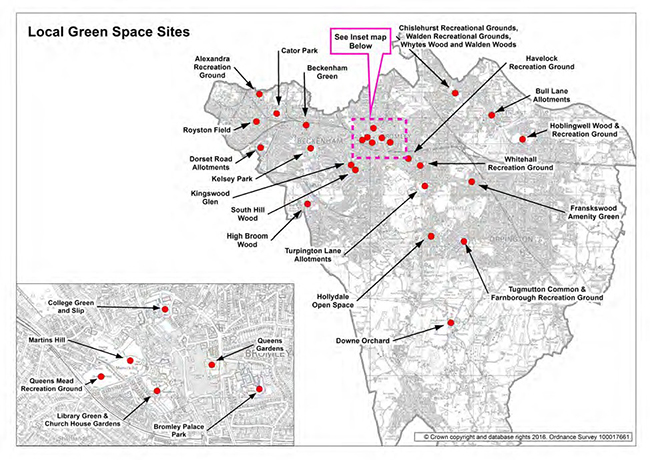
Local Green Space Site Boundaries and Statements of Significance
This Appendix shows the boundaries and Statements of Significance of the 25 sites proposed for designation as Local Green Space in the Local Plan, in alphabetical order. These sites are displayed on the map below.
Local Green Space Sites
| Site 43: | Alexandra Recreation Ground |
Alexandra Recreation Ground- Statement of Significance
This local park was opened by the Council in 1891 and retains some of its original layout including the circular footpath and mature trees which closely follow the park’s border. The original park area was north of Maitland Road, the southern part having been added in the early 20th century. A late 19th century locally listed granite drinking fountain erected in 1891 by the Metropolitan Drinking Fountain and Cattle Trough Association, stands in the footpath where the northern half of the park meets the southern green.
The park provides a range of recreational facilities including playing fields to the north (now used by Seymour Football Club), a centrally located 1930s bowling green and paddling pool (one of only two in the borough) with a picnic area and a wooded fenced off children's play area to the south. It is a link in the Green Chain and Capital Ring walks and is easily accessible through Bromley’s local cycle network. The Friends of Cator Park and Alexandra Palace organise a number of community events in the park including bird walks, tree walks and gardening sessions.
There are views from the north east towards the Crystal Palace transmitting station to the west, the spire of the locally listed Holy Trinity Church on Lennard Road to the north and of the streets of Victorian properties on Maitland Road and Alexandra Road from the south. Benches scattered around the park enable enjoyment of these views and of the park’s quietness, which provides a resting place away from the A213 to the east.
| Site 44: | Beckenham Green |
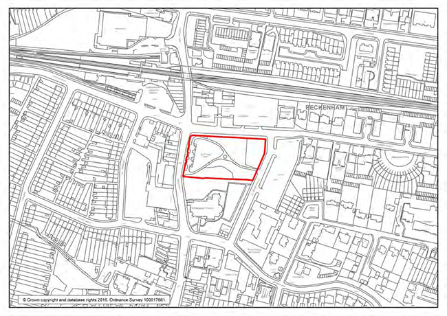
2. Beckenham Green- Statement of Significance
This local park was laid out in 1967 on a site derelict for years following significant Second World War bomb damage to this part of Beckenham Town Centre. An area of the park to the east, now in use by the children of Bromley Road Primary School, was safeguarded for pupils of adjacent schools at the time.
The park forms part of the approach to Beckenham High Street from the north providing a green which is relatively quiet to the adjacent high street as well as a resting place for visitors to the town centre. The green is contiguous to St George’s Church’s green to the south and there are views of the church's spires over its northern tree boundary. It softens the transition between the 19th century character of the town centre which includes the Church and shopping parades on the high street and more modern development on Rectory Road. The park includes lawns and flower beds with mature trees along its borders including a row of London Planes along its northern edge and a wilder area of woodlands on the southern boundary. It is regularly used by local business owners and residents to host community events including markets, concerts and performances which make use of its central stage, and also religious processions.
| Site 45: | Bromley Palace Park |
Bromley Palace Park - Statement of Significance
This park, which features a lake to the east, provides a striking setting to a number of historic assets. It includes the remains of the landscaped grounds of the former palace and official residence of the Bishop of Rochester (sold to Mr Coles Child, a merchant, in 1845). The lake forms part of the Saron moat dug by Saxons for their Norman conquerors. There are long views towards the landscaped forecourt of the Grade II Listed Bromley Palace building, erected in 1775 for Bishop John Thomas, across the lawned area to the west of the lake. The site of the former St Blaise well at the lake’s northern tip is occupied by a modern fountain adjacent to a Grade II listed 19th century rockery created by James Pulham and Sons for Coles Child. There are views towards a fountain across the lake from this site. To the south of the lake and beside the Grade II Ice House is a second listed larger Pulhamite rockery. The low brick wall parallel to the footpath at the south end of the lake may be a 18th Century ha-ha or the work of James Pulham and Sons.
The site is a designated Site of Local Importance for Nature Conservation retaining mature ornamental trees alongside wilder areas and woodlands by the lake. Its key features are described in the 2009 SINC citation. The park is a key stop on The Friends of Bromley Town Parks and Gardens heritage walk. It is used for leisure by local residents and as the setting for wedding parties. It provides a quiet space off Kentish Way to the west and Widmore Road to the north and is a valuable open space in an area of deficiency.
| Site 46: | Bull Lane Allotmenets |
Bromley Lane Allotments- Statement of Significance
Bull Lane allotments were laid out in 1884 to provide income for the rector and food and employment for the working families of Chislehurst. Continuous use as allotments has improved the fertility of the soil. The site provides a secluded and beautiful recreational space primarily enjoyed by the community of allotment holders for the benefits they provide in terms of relaxation, locally grown food and access to nature. Over 80 plots are laid out in a lawned area enclosed by high hedges and trees with views towards the eastern elevation of the Statutory Grade II Listed early 20th century Easden House which sits adjacent to its north-western boundary. The allotments provide a quiet space approximately 100m from Bromley Lane (the A22) to the north and Royal Parade (the A208) to the east. They are open to all sections of the community and include a plot for children of the local St Nicholas School in Chislehurst Common Road.
Some plots are used as a nursery to nurture native trees and shrubs destined for Chislehurst Common. There is also a small orchard and a small pond. The site’s biodiversity benefits from its use as allotments and it has been documented to accommodate common shrews, frogs and toads as well as slow worms. The north western hedgerow includes a good mix of native species including common hawthorn and hazel, providing important shelter for birds, invertebrates, mammals and reptiles. Uncut areas of long grass provide an important habitat for invertebrates such as butterflies and caterpillars and the site includes a variety of nectar sources which can generally be considered to benefit pollinators.
| Site 47: | Cator Park |
Cator Park- Statement of Significance
The local park forms part of Aldersmead Road Conservation Area. Laid out in 1885-1889, it was formerly known as the Kent House Pleasure Gardens which formed part of the Cator Estate and remained enclosed for local frontagers until acquired by the Local Authority in 1932. There are important views towards the semi-detached Victorian properties on Aldersmead Road over the park’s western hedge. The park retains much of its original layout together with some very old mature trees. Tree species include Corsican pines, pedunculated oaks, pines, narrow leaf ash and limes.
The park fulfils a range of recreational functions as it includes a children’s playground to the east and sports fields to the north (now used by Langley Junior Football Club). It also serves as an important link for the Green Chain, Capital Ring walks and Bromley’s local cycle network.
Pipistrelle and Daubenton’s bats feed along the canalised Chaffinch and Brook rivers. The hedge on the south-eastern boundary has a mixture of oak, ash, field maple and traveller’s joy providing cover for wildlife. The park also has areas of long vegetation, a good nectar source for pollinators. The Friends of Cator Park and Alexandra Recreation Ground organise a range of community events such as green chain walks, summer walks, bird walks, bat walks and tree walks.
| Site 48: | Chislehurst Recreation Ground, Walden Recreation Ground, Whytes Woodlands and Walden Woods |
Chislehurst Recreation Ground, Walden Recreation Ground, Whytes Woodlands and Walden Woods - Statement of Significance
This local park brings together (from North to South) Chislehurst Recreation Ground, Whytes Woodlands and the adjacent bird sanctuary, Walden Recreation Ground and Walden Woods.
Chislehurst Recreation Ground formed part of the manorial grounds of the Lord of Chislehurst. It was acquired by the Chislehurst and Sidcup District Council for use as a recreation ground in the early 20th century. Whytes Woodland was conveyed to the District Council in 1938 by owner Agnes Kay Whyte for the benefit of the local community. A part of the woodland was preserved as a bird sanctuary with no access. At that time Walden Recreation Ground was also sold to the UDC.
The combined sites are shielded from the A208 by residential properties and other development and are used for informal leisure activities by local residents. There are also a range of recreational facilities: The Invicta Scouts hut is located on Chislehurst Recreation Ground, which is also home to Elmstead FC which secured funding to improve the now floodlit football pitches, and Chislehurst Tennis Club. There also is a children's playground. The Friends Group are actively involved in maximising the site’s health, recreational and educational benefits. They have raised money for a fitness trail and secured a community grant from to fund the provision of lighting to facilitate youth activities after dusk. They have also supported initiatives such as the national Walk for Health. The sites have also been used as outdoor classrooms by the pupils of Red Hill School and by scouts. The Friends Group organise events such as the music festival Chislehurst Rocks, and an annual fireworks in partnership with other stakeholders.
The Green Chain walk links the residential areas to the west and Red Hill to the south. It provides a shortcut for locals to local shops and facilities and to and from Elmstead Wood Station. Chainsaw wood carvings funded by local businesses were installed in 2013 on the footpath linking Chislehurst and Walden Recreation Grounds. There are views from Chislehurst Recreation Ground to Church of the Annunciation of the Blessed Virgin Mary on the high street.
| Site 49: | College Green and Slip |
College Green and Slip - Statement of Significance
The College Green and the Slip were originally part of the Land of Bromley College’s Almshouses. It was opened as a public park in 1985. The site is a setting to a number of historic assets. No. 11 College Slip is a prominent locally listed 19th century cottage to the north of the slip, the public footpath which links the upper end of Bromley’s High Street to West Street. There is a listed telephone kiosk at the junction of the Slip and of the entrance to The Green. The Green also provides important rear views of Bromley and Sheppards College from and across the site from West Street.
The Green and the Slip’s amenity and biodiversity values have been enhanced by Bromley’s ‘Green Gym’, an initiative from Bromley’s Conservation Volunteers which aims to improve mental and physical health through the undertaking of practical conservation activities in green spaces. They have also taken steps to make the site’s historic relationships with the grounds of Bromley College more apparent. The volunteers planted an orchard of fruit trees and an herb garden to reflect its former use by the kitchen of the almshouse. At the heart of College Green is an ancient mulberry tree which dates from the late 17th/early 18th century. A circular bed planted with plants from the 17th century Tradescant List including Solomon’s seal and Lilly of the Valley currently surrounds the tree.
The Green includes seating areas used by local workers and visitors to Bromley Town Centre. Wooden benches have been designed and installed by the Green Gym volunteers. The volunteers have also built an insect hotel and beetle loggeries and planted a woodland area mixed with wildflowers featuring hazel, hawthorn and field maple, providing a good habitat for birds and a nectar source for pollinators. Raised beds have been planted with wild strawberries, poppies and geraniums. The Slip’s verges have been planted with meadow seeds and feature a dead wood hedge designed to attract insects.
| Site 50: | Dorset Road Allotments |
Dorset Road Allotments- Statement of Significance
These allotments, (formerly known as the Churchfield Road Allotments), have been in use for over a hundred years and were granted a Green Flag Community Award by the DCLG for eleven consecutive years. The allotments are surrounded by woodlands and there are two streams running through the site with riverbanks rich in berries and flowers including bluebells. The wildlife garden (accessible by wheelchair), was funded by an ‘Award for All’ grant, secured by the Dorset Road Allotments and Leisure Gardens Association and features native hedges, a wildflower meadow and a pond with amphibians. Logpiles and a hibernaculum provide homes for slow worms and reptiles. There is a bee apiary and the allotments provide a habitat rich in nectar sources for the bees. Protected bird species including the lesser spotted woodpecker, house sparrows and song thrushes have been seen on site.
The allotments are open to the public during set times at the weekend and open community events such as bonfire nights and fundraising days are regularly held on site. They are regularly visited by local school and scout groups. Plot holders include the local Stewart Fleming Primary School on Witham Road and Chaffinch Brook School in Croydon. The site also includes a dog training area, a shop and clubhouse building and a picnic area.
| Site 51: | Downe Orchard |
Downe Orchard Downe Orchard- Statement of Significance
The publicly accessible orchard was planted in March 1992 by local residents on disused allotments land and features a wide variety of Kentish apples including Bascombe’s Mystery, Cobham, Colonel Vaughn, Gooseberry Apple, Mabbotts Pearmain, Kentish Fillbasket and Tydeman’s Orange. The site’s biodiversity value is recognised by its proposed designation as a Borough Grade II Site of Importance for Nature Conservation. Key features are described in the 2011 citation. Local residents have enhanced the site’s biodiversity by seeding the land with wildflower mix and planting mistletoe in the trees. ‘Apple Day’ is celebrated and there are pruning and mulching days. The site is also used for walks and for picking apples.
| Site 52: | Frankswood Amenity Green |
Frankswood Amenity Green – Statement of Significance
The green was included as a key feature of the Morell Estate, a suburban development laid out in the 1930s following Garden Suburb principles. It marks the approach to the Petts Wood area. Mature trees prolong wooded vistas along Frankswood Avenue and Lakeswood Drive. The green is an important amenity for local residents including the local parishioners of the adjacent St James the Great Church, local scout groups and the wider community.
| Site 53: | Havelock Recreation Ground |
Havelock Recreation Ground- Statement of Significance
Havelock Recreation Ground, locally known as “The Brickfield”, is accessed via a public footpath off Homesdale Road (the A222) where it provides a quiet and secluded green space shielded by the surrounding residential properties.
The site became an Asset of Community Value in 2015, having been nominated by the Friends of Havelock Recreation Ground. Existing brickworks were extended to this site by Coles Child, a merchant and Lord of the Manor, in Victorian times. The disused brickfield was converted into a recreation ground by Bromley Council in 1963. The grounds have been used by the 3rd Bromley Scouts Group since its opening for games and other scouting activities. It is also used by the local Raglan Primary School for outdoor activities and for general fitness and leisure activities by local residents. The Friends of Havelock Recreation Ground frequently organise local community events including picnics, hoedowns and Dog Olympics. Some of these events have been sponsored through donations of the Homesdale Road and Chatterton Road business communities.
The site’s biodiversity, which is in an area known to be deficient in access to nature, has been enhanced and improved through activities organised by the Friends Group such as bulb and hedge planting. There are hedgerows of native species on the site, which provide a good habitat for birds; house sparrows, common black-headed gulls and starlings have been sighted. There are areas of long grass which are good for pollinators as well as mature specimen trees on the eastern corner. The site also hosts a population of stag beetles. The Friends Group have organised biodiversity-related fun or educational events such as bird box painting and bug hunting sessions for children and families.
| Site 54: | Hollydale Open Space |
Hollydale Open Space - Statement of Significance
The local park provides a quiet spot at the heart of a residential area bounded by the busy Oakley Road (A233) to the West, Hastings Road (A21) to the East and Croydon Road (A232) to the south.
The park used to form part of the grounds of Hollydale House which belonged to the Fitzpatrick family in the mid-18th century. At that time, the grounds were landscaped and the river rising in Holwood was dammed to create two ornamental lakes. Following the house’s demolition in the 1930s, the grounds were acquired by the Council. Parts were sold off to be developed and the surviving lakes and some woodlands were included as part of a public park. The stable blocks remain as private dwellings at 32 Croydon Road, nearby the site’s southern entrance. It is cut off from the open space by parts of the former brick kitchen garden wall. The park still includes trees and shrub specimens brought back by members of the Fitzpatrick family who worked for the East India Company. Some of the trees in the park are over 150 years old. The site’s lawned area to the north east features a gazebo moved from Crystal Palace Park. The Friends of Hollydale Open Space organise heritage walks.
The park has wheelchair friendly paths leading to the lake and to a children’s playground improved through a grant from Award for All obtained by the Friends of Hollydale Open Space. It is enjoyed by local residents through a variety of informal leisure activities. A range of community events prompted by the Friends Group take place in the park including family days and Easter egg hunts.
The park has important biodiversity value recognised by its designation as a Site of Local Importance for Nature Conservation proposed to be extended to the north in 2011. The small oval island at the centre of the lake is a nature conservation area funded by a grant from Veolia’s Environmental Trust secured by the Friends group. Common pippistrelle, soprano pippistrelle and Daubenton’s bats forage in the park and there are kingfishers, woodpeckers and herons. Many areas have been planted to attract bees, butterflies and insects. The friends group have installed a stag beetle loggery. They organise events revolving around the park’s wildlife including bat walks, tree walks and nature walks.
| Site 55: | High Broom Wood |
High Broom Wood- Statement of Significance
High Broom Wood was part of the Monks Orchard Estate in the mid-19th century. The woods became distinct from the estate following the construction of Bethlem Hospital in 1928, Monks Orchard Road in 1931 and of residential areas to the east in the 1950s and 60s. There are still ornamental trees on the site including acacia robinia and pseudo acacias.
The woods are a recognised Site of Metropolitan Importance for Nature Conservation (SINC). The site features dense areas of woodland along the natural River Beck corridor. This stretch of the River Beck is one of the remaining few where banks are naturally formed and is the recognised border with Croydon and between Surrey and Kent.
The woods include an area of Semi-Natural Ancient Woodlands edged by mature oak and robinia, with key features described in the existing SINC quotation. These include veteran trees with species such as sweet chestnuts and oaks. Deadwood piles have been left by the Friends Group to encourage insects that rely on decaying wood such as stag beetles. The rest of the woods include areas of mainly alder woodlands to the south east of the river and areas of younger woodlands to the North West which feature young ash, sycamore, cherry trees and alders. There are small areas of damp woodlands which include leaved golden saxifrage, kingcup, lady’s smock, wavy bittercress and pendulous sedge, all regionally rare in London. Bird species sighted in the woods include, goldcrest, bullfinch and grey heron. The site is home to bats and other mammals.
In addition to actively seeking to enhance the site’s biodiversity, the Friends of High Broom Wood play a key role in promoting it organising events including bat walks, lectures to senior citizens, school students and organisations such as the Soroptimist Society in Beckenham or West Wickham’s Emmanuel Church Fellowship Group.
A 2011 grant from Transport for London led to the installation of chainsaw carved work and seating, wheelchair and pushchair friendly paths and interpretation boards. Bromley’s 7th Scout Group use the site to obtain their nature badge. The Woods are used by local schools and cub groups for forest school, nature walks, plant/animals identification studies, country running and orienteering. It is part of the Beck Trail corridor route linking the Green Chain, Capital Ring and the London Loop walking routes and is easily accessible via the Council’s local cycle network. The site is also regularly used by local residents. It is a particularly quiet area relative to the nearby South Eden Park Road and Wickham Road.
| Site 56: | Hoblingwell Wood and Recreation Ground |
Hoblingwell Wood and Recreation Ground - Statements of Significance
The name Hoblingwell derives from the reference in ancient folklore to the “well of the hoblinga”, hob’s people in anglo saxon otherwise known as hobgoblins. According to ancient legends, the woods have been the haunt of evil spirits, goblins and witches.
The extent of Hoblingwell Woods’ biodiversity and richness of wildlife is recognised though its designation as a Grade II Site of Borough Importance for Nature Conservation. The SINC area includes ancient semi-natural woodlands, meadows, fruit trees (including apple trees and blackberry bushes), a pond, wetland and a stream. It is home to over 120 species of birds including woodpeckers and tree creepers. A 2015 survey evidenced that palmate newts and common frogs use the pond. The woods form a vital foraging area for pipistrelle bats which feed over the wet areas on their way to the Cray Valley. The Friends of Hoblingwell Woods and Recreation Ground have promoted the site’s nature conservation value as an educational resource by organising nature walks and photography courses for staff and students of the local Cotmandene Community Centre in Orpington, through bat walks and getting students of Bromley College’s Prince's Trust Programme to partake in nature conservation activities and improve the park’s access and paths. This educational function is particularly important in an area which suffers from particularly high levels of deprivation particularly when it comes to income, employment, health and disability and skills and training.
Hobligwell Recreation Ground includes important local recreational infrastructure. It has five football and rugby sports pitches which have been used by Orpington Rugby Club and the River Cray Football Club since the 1970s and by the Kent Exiles Football Club for 15 years. The Orpington Rugby Club have funded the provision for floodlights on the pitches. There is also a children’s play area adjacent to a basketball court. There are panoramic views of St Mary Cray from the south and of Bexleyheath and Dartford from the north east of the site
| Site 57: | Kelsey Park |
Kelsey Park- Statement of Significance
This local park is a quiet space within walking distance of the heart of Beckenham Town Centre to the south, and accessible from the local cycle network on Manor Way.
The park opened in 1913 on the grounds of the former Kelsey Estate. The estate was gradually landscaped by the Burell family following its acquisition by Peter Burell I, a London merchant, in 1690. It is believed that Humphrey Repton (1752-1818) was responsible for redesigning the landscape, adding the upper lake with the waterfall to the existing lower lake. Some trees and the locally listed ice well to the south may also date from that time. The park was acquired by Beckenham District Council in 1912 following a local campaign. A lodge, still standing, was built on the High Street entrance.
The park today features two intertwining lakes with a rockwork cascade to the northern end, as well as serpentine walks, formal gardens and lawns backed by specimen trees including cedars and wellingtonia, wilder areas and woodlands.
To the south are a range of recreational facilities including a children's playground, a cafe, tennis courts and a golf course. An information and education centre run by The Friends of Kelsey Park is accessible via the park's main entrance. The park is the starting point of a weekly walk which takes place as part of the national Walking for Health scheme.
The site's biodiversity value and richness of wildlife are recognised through its designation as a Grade II Site of Borough Importance for Nature Conservation, with a description provided in the 2009 SINC citation. The lake serves as a feeding area to common pipistrelles, sopranos, daubenton and leisler bats and there is a heron island in the park. Sighted bird species include a kingfisher, grey herons, a dunnock and black headed gulls.
The park’s woodlands, herbaceous borders and wilder areas provide important breeding grounds and nectar sources for insects and bees. The Friends Group promotes the park as an educational resource and publishes nature and historic guides for children. The group organise wildlife related activities such as bird watches, including a heron watch organised in partnership with the Royal Society for the Protection of Birds, bat walks and moth watches. They also organise other community events, such as an Easter Egg Hunt and musical afternoons.
| Site 58: | Kingswood Glen |
Kingswood Glen- Statement of Significance
The site was bequeathed to the borough of Beckenham as a deed of gift by two local women in 1962 to be preserved for the benefit of the community. It is a small publicly accessible open space on a hill, once the site of an Iron Age hill fort and Roman camp.
Kingswood Glen is traversed by a dual pedestrian/cycle way which is a link in the Borough’s Local Cycle network. This is utilised by local residents and pupils on their way to Bromley town centre and Highfields Primary School on South Hill Road.
It is a designated Grade II Site of Borough Importance for Nature Conservation with key features described in the SINC citation. It features ancient semi-natural woodlands. The site includes four ponds which have developed in the ramparts of the Iron Age hill fort and support important wildlife including several species of British amphibians. The larger pond, funded by the Veolia Group improved the variety of wildlife. The Friends of South Hill Wood and Kingswood Glen organise monthly work days attended by volunteers to preserve
| Site 59: | Library Green and Church House Gardens |
Library Green and Church House Gardens- Statement of Significance
The Church House Gardens were landscaped by Abel Moysey, who leased the land from the Bishop of Rochester’s agent in 1832 and created lawns, shrubberies, and fishponds. Library Gardens was bequeathed to the Council in 1900 and opened to the public in 1906. Church House Gardens were bought by the Council, connected to the library gardens and opened to the public in 1927.
The Lodge by the Glassmill Lane entrance to the park is a late Victorian park keeper's house in the arts and craft style. The park’s steep slopes, planted with azaleas and rhododendrons, descend towards a lake to the south which brings together two spring ponds. There is balustrading on the edge of the steep terrace to the north which remains from the original private gardensand there are views towardsShortland’s skylinefrom this spot.The rockery below was made from stones reclaimed from the bombed parish church. There is also a section of Tudor wall thought to be from the kitchen garden wall of the 'Grete House' demolished in the early 19th century. Concrete seating by the lake was designed as an amphitheatre in the 1920s as a job creation project and was remodelled in 2008 to include a stage area. It faces a stage area on the other side of the lake which dates from the late 1970s. A mill was recorded at the site of the millpond from the early 11th century. The pond was reconfigured in the 1950s as part of the Ravensbourne flood prevention scheme.There are views of 19 Glass Mill Lane, a picturesque 19th century weather-boarded cottage, from the footpath adjacent to the pond.
The combined sites have important local recreational value. Church House Gardens has locally unique skateboarding facilities, tennis and volleyball facilities, a five-a-side sports court, basketball courts, a sand and water play area and a playground. The amphitheatre by the lake is used for local performances. The sites are in close proximity to Bromley town centre and widely used by local residents, workers and shoppers for informal leisure activities. They form part of the informal scenic route which links Bromley town centre to Shortlands Station passing through Martin's Hill and Queens Mead further south.
Most of Church House Gardens and the millpond is a Site of Local Importance for Nature Conservation, a designation which recognises its biodiversity value and richness of wildlife.
| Site 60: | Royston Field |
Royston Field Royston Field - Statement of Significance
The site was acquired by Penge Council as a school playing field for the local Royston School in 1927 and safeguarded as a public park which opened in 1990 after the school moved.
This open space provides a small albeit valuable recreational spaces in close proximity to Penge town centre in an area which is scarce in publicly accessible green spaces. The goalposts on the site enable young local people trained by staff from Penge’s Christ Central Church and the local Gambian and Sierra Leonean team to play football regularly. The site is also used for other informal leisure activities, particularly by local children. The park has been used as a focal point for events organised by the Friends of Royston Field including the Penge Festival Fete, the Pengeleum Youth Music Festival, Art in the Park and Jazz in the Park etc.
A dual use pedestrian/cycle path goes through the space. It is used as a shortcut between the surrounding residential areas and Penge’s high-street. The park is in an area where there is a deficiency in access to nature however, the Friends Group, helped by scouts and cubs from the local Christ Central Church, have been improving its biodiversity by planting native hedges, bulbs and oak trees. The Penge Congregational Church has also planted trees there for its centenary.
| Site 61: | Martins Hill |
Martins Hill Martins Hill- Statement of Significance
This local park, formerly in the grounds of the Manor of the Bishop of Rochester was bought by the Bromley Local Board in 1878 and established as Bromley's first public park. It retains some of the open-fields/semi-rural character which was typical of the area up until the end of the 19th century. The Church Road entrance features a Grade II Listed War Memorial, used for annual remembrance services, which stands on a lawn ornamented with flower beds and gated by ornate iron railings, as well as an altered Victorian lodge which retains some of its original layout and features.
The hill slopes down towards the Ravensbourne River offering extensive views across to Crystal Palace’s transmission tower and the Sydenham Ridge, to Shortlands and the Grade II listed historic pumping station’s chimney on Queens Mead Road and Addington. It is used by local residents for various informal leisure activities – including tobogganing on its slopes in the winter, for respite by visitors to Bromley town centre and by commuters and residents as a link in the scenic route between Shortlands train station and the town centre. The site also features a large children’s playground.
Martin’s Hill biodiversity value is recognised by its designation as a Site of Local Importance for Nature Conservation particularly valuable in this part of Bromley which is recognised for being deficient in access to nature. It is acid grassland with woodland on the northern boundary which includes mature specimens and much holly. The Slopes are home to the Common Broom from which Bromley’s name is derived from (Bromleag). The site’s biodiversity is partly looked after and enhanced by the Friends of Bromley Town Parks and Gardens.
| Site 62: | Queens Gardens |
Queens Gardens- Statement of Significance
White Hart Field which formed part of Bromley Palace farm land was donated to the town in 1897 by the merchant Coles Child, Lord of the Manor. Bromley’s first homeopathic hospital was built on part of the site whilst the remainder was laid out as a recreation ground in 1900 and named Victoria Gardens in celebration of Queen Victoria's Diamond Jubilee. The local park is now known as Queens Gardens. The fine iron ornamental gates to the south of the gardens date from the 1850s. They were donated by Lord Kinnaid, a close friend of Coles Child and moved from Plaistow Lodge, his private residence on London Lane.
The original White Hart Field was traversed by a diagonal slip leading to Market Square. Queens Gardens retains public footpaths and remains an important link in one of the routes between the Civic Centre to the west of Kentish Way and the High Street. Its lawns and seating are popular with local residents, workers and shoppers, primarily for relaxation purposes, especially as it is particularly tranquil in relation to the busy adjacent town centre and to Kentish Way (the A21). The Gardens are also easily accessible via the Borough’s local cycle network which goes through nearby major roads including Kentish Way.
The gardens provide an important open visual break from the multi-storey shopping centre. They also retain their original layout in terms of the position of its lawns and footpaths. They include mature and semi-mature ornamental trees including fine copper beeches.
| Site 63: | Queens Mead Recreation Ground |
Queens Mead Recreation Ground - Statement of Significance
Queen's Mead Recreation Ground was purchased by Bromley’s Local Board in 1897 to celebrate the reign of Queen Victoria and set aside for recreational use. There are significant views from this local park towards Martins Hill, the statutory listed St Peter and St Paul Parish Church on Church Lane in Bromley to the north and of the statutory listed historic pumping station’s chimney on Queens Mead Road, in Shortlands, to the south. There is a locally listed Victorian drinking fountain close to the sports pavilion north-west of the site.
The recreation ground is used by Queensmead Football Academy on a regular basis and by local residents for informal leisure activities. The site is accessible via the local cycle network which goes through Queens Mead Road to the north. The site forms part of the scenic walking route between Bromley Town Centre and Shortlands Station which includes St Martins Hill, Church House Gardens and Library Gardens.
| Site 64: | South Hill Road |
South Hill Wood - Statement of Significance
In 1876 the site of Tootes Wood was acquired by Sir Thomas Charles Dewey, Charter Mayor of Bromley and a renowned local benefactor. He was made Baronet Dewey of South Hill Wood as a reward for his patriotic duty in his role as a member of the War
Expenditure Committee in the Cabinet Office. He commissioned architect Evelyn Helicar to transform the site into a garden for his house, which stands adjacent to the site’s eastern boundary at 1 South Hill Road and is now on the Council’s Local List.
The Victorian villa and the park do retain a relationship as there are views towards the rear of the villa from the park’s eastern entrance. Sir Dewey used the music pavilion then on site as a makeshift hospital for the wounded during WW1. The perimeter wall on Tootswood Road features bricks saved from the original garden walls which display marks and graffiti left by Canadian soldiers billeted in the area during the two World Wars.
The garden was compulsorily purchased by the Council then established as a public park in 1959. Features of Dewey’s original garden including the original Hellicar fountain, remnants of the sunken gardens and of the original flora – such as a giant sequoia tree planted by Dewey, remain in the Local Park to this day. The entrance gates to the park are coronation gates originally intended for the Harrington Estate. The site includes locally important recreational facilities including a bowling green on the site and a privately owned tennis club used by the local Highfield Junior School on South Hill Road. The park has wheelchair accessible paths and is used for informal leisure activities by local residents. It is also used as a shortcut to local shops on Westmoreland Road and other facilities, including the Highfield Junior School on South Hill Road. The School also uses the park for cross country club activities. The park's recreational facilities are particularly important locally as most of Shortlands Ward is recognised as having a deficiency in local parks.
The site's biodiversity value is recognised through its designation as a Site of Local Importance for Nature Conservation but more recent surveys have been conducted since the site was designated, indicating the presence of further important habitats and species for Bromley. The site is an important foraging site for pipistrelle bats. The blackheaded gull, the European green woodpecker and the goldcrest have been recorded on the site. The site is mainly oak and ash and includes remnants of ancient woodlands indicated by the presence of species such as wood anemones, English bluebell, and solomon’s seal. The white admiral butterfly species has been spotted. The Friends Group have made improvements to the local biodiversity including planting trees and woodland plants and building bird, bat and insect homes. The park is used also by the Highfield School for nature walks. The banks of the ancient green lanes that allowed people to travel from Bromley to Beckenham can still be found in the woodland.
The site provides tranquillity some distance away from Westmoreland Road and Hayes Lane and can be enjoyed by local residents using benches located at quiet points within the park.
| Site 65: | Turpington Lane Allotments |
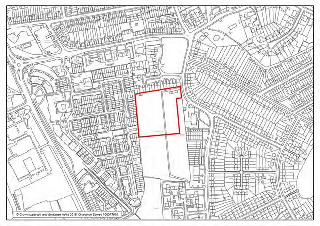
Turpington Lane Allotments- Statement of Significance
These allotments established in 1926 and laid out by local people, are site with the largest capacity within a one kilometre radius. A committee room and trading store (still in operation), were built by the allotment holders and opened by the Mayor Alderman J L Hunt in 1963. The allotments were used to provide food during Second World War rationing.They support the objectives of the Bromley Common Allotment Gardens Association including the provision of facilities at an affordable rent, encouraging the residents of Bromley to further their interest in horticulture and foster cordial relations with the allotments community and particularly the residents of Bromley Common.
The allotments are open to the public at set times during the weekend together with the viable trading store, one of the few still functioning in the borough. The store’s social room offers a physical space for networking and sharing ideas. They support a range of social and community events such as the yearly horticultural competition organised by the Bromley Allotments and Leisure Gardens Federation, in house scarecrow, sunflower and pumpkin competitions as well as barbecues. The allotments feature a range of facilities particularly suited to the elderly including the trading store and social room, car parking, stock storage and lock-up facilities, toilets and resting benches. It is a quiet area a short distance to the east of the A21. It also provides a secure play area for children. The Allotments Association delivers compost to local elderly neighbours. The allotments are valued by their users for the benefits they provide in terms of relaxation, growing food locally and access to nature.
| Site 66: | Tugmutton Common and Farnborough Recreation Ground |
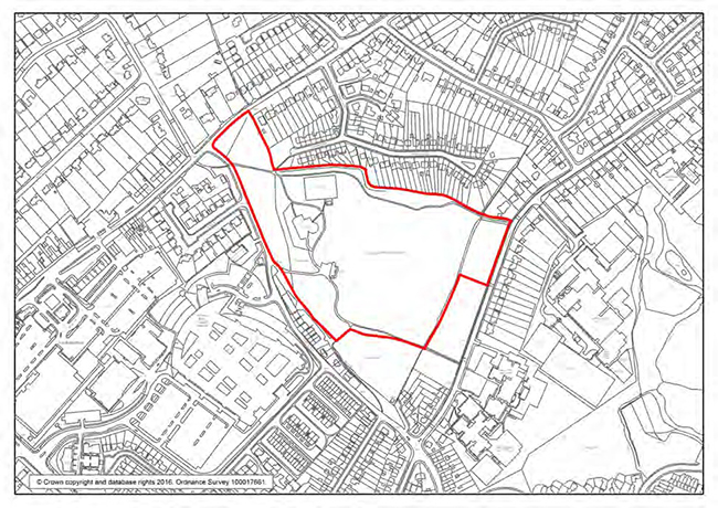
Tugmutton Common and Farnborough Recreation Ground - Statement of Significance
This local park brings together a range of recreational facilities and amenities including Tugmutton Common which is a grassed area to the north east, private local tennis and cricket facilities, a children's playground, football goalposts and one of the borough’s only two green gyms. Local residents also use the site for informal leisure activities.
The site's overall biodiversity is recognised by the existing designation of an area around the river as a Site of Local Importance for Nature Conservation and its proposed extension to most of the site. In partnership with the London Borough of Bromley, the Friends of Tugmutton Common have developed a wildlife area east of the stream which includes meadows, woodlands, hedgerows, bee-friendly wildflower plots, areas of long grass attractive to invertebrates and a living hedge. Paths and rustic benches have been laid on the footpaths of the wildlife area accessible via a wooden bridge crossing the stream. Interpretation boards have been placed at the area’s entrance. The following declining higher plants have been evidenced on the site: native bluebells and upright chickweed.
| Site 67: | Whitehall Recreation Ground |
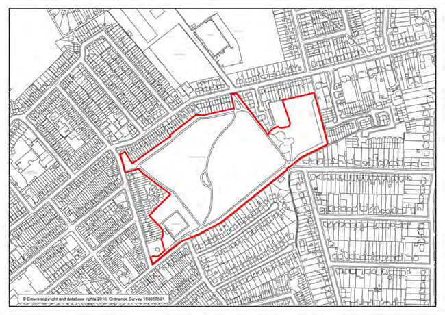
Whitehall Recreation Ground Whitehall Recreation Ground- Statement of Significance
Whitehall Recreation Ground opened as a public park in 1905 after local fields were purchased by Bromley’s Urban District Council for the inhabitants of Bromley Common and Bickley. David Bowie grew up local to the area and the park features in the video clip made for the song Buddha of Suburbia, produced in 1993.
Whitehall Recreation Ground features a bowling green, football pitches, a sports pavilion, a children’s playground, and a picnic area. The park is used by Raglan Primary School on Raglan Road for a range of events including sports days, running sessions and a carnival. It is also used by the 5th Bromley Scout Group for various sporting and outdoor activities and by Bromley FC Rooks Under 12 team. It is the starting point of the Bromley Walk to School scheme. The Friends of Whitehall Recreation Ground regularly organise community events such as a yearly Easter Egg Hunt, Family Fun Day, Beer Festival, Apple Day and a Halloween story telling day. Local businesses in Chatterton Village have contributed to sponsoring these events.
The park’s visual amenities includes views of the spires of Bickley’s St Luke Church to the south-east and St George’s Church to the east, avenues of mature chestnut and lime trees to the north and the south and the footpath laid out diagonally across the park which leads to a quiet central island featuring a tree, ornamental beds and seating. The site’s picnic area by the orchard is also a particularly peaceful spot.
Whitehall Recreation Ground is in a recognised area of deficiency in access to nature. The site’s biodiversity has however steadily improved over the years. There is a wildlife area with neutral grassland meadow featuring native wildflowers, an orchard, herbaceous borders with nectar rich plants (including small leaved lime, rock rose and mistletoe) and hedgerows with mixed native species which all provide important food sources for moths, butterflies and bees. Common frogs use the pond and the area of scrubs around the pond and at the back of the fenced wildlife area provides a good habitat for invertebrates, nesting birds, and hibernating amphibians, Bird boxes decorated by local children and bat boxes, some used by pipistrelle bats have been placed in the trees. Starlings and black headed gulls have been seen foraging on the site. There is also a stag beetle loggery. 2005 BBC Breathing Spaces funding has been instrumental in funding some of the improvements. Bromley’s Conservation Volunteers, though their “Green Gym” which brings together volunteers looking to improve their well-being by working in green spaces, have also been involved in improving the park’s biodiversity and accessibility. In addition to seeking grants and being involved in improving the site’s biodiversity and wildlife, the Friends Group organise events such as pond dipping and bird, bat and tree walks.
Shopping Frontages
The primary and secondary shopping frontages detailed below relate to Policies 92 to 96 in Section 6.2 Town Centres
The Council considers these frontages to be "Key Shopping Areas" within the Borough.
| Primary Frontage | Secondary Frontage | |
|---|---|---|
| Metropolitan Town Centre | ||
| Bromley Town Centre | Bromley Shopping Centre (formally the Glades) East Street 1, 3 High Street 44-48(e), 52-70(e), 72-184(e), 93-167(o), 157a, 53-81 Market Square 1-6(c), 8, 12-36(c) White Hart Slip Widmore Road 2-10(e), |
East Street 2, 2a, 4, 4a, 6-48(e), 19, 19a, 19b, 21a, 23, 29-39(o), 39a, 41a, 41b, 43, 45, Market Parade 2-6 East Street Elmfield Road 1, 3, 10, 12, 14 High Street - north 171-241(o), 181b, 194- 262(e) High Street - south 1-51, 2-40(e), 40a, 42, Ravensbourne Road The Mall 1-34 Westmoreland Place Widmore Road 1-37(o), 23a, 25a, 9, Market Square |
| Major Town Centre | ||
| Orpington | High Street 115-123(o), 135-179(o), 187-205(o), 209-231(o), 235-249(o), 253-277(o), 136, 142-290(e), 190a, 322a, 138, 140 Homefield Rise Sainsburys The Walnuts 1-89(c) |
Chislehurst Road 1-9(o) High Street 73-83 (o), 91a, 85-97(o), 99-107(o), 111-113(o), 279-311(o), 86-90(e), 92-108(e), 112-122(e), 120a, 124, 126-134(e), 292-352(e) Tesco Stores (Augustus Lane) |
| District Centres | ||
| Beckenham | High Street 94-110(e), 112-134(e), 138-158(e),
162-174(e), 176-182(e), 182a, 184-242(e), 242a,
244-272(e), 276-294(e), 115-141(o), 145-153(o), 157, 159-169(o) |
Beckenham Road 3 Bromley Road 2 Croydon Road 399-425(o), 433-439(o), 404, 408-420, 426-436(e) 1-11 Albemarle Road High Street 1-9, 41-71(o), r/o 71, 73-77(o), 81-83(o), 87-103(o),111, 171-195(o), 199-215(o), 221, 223, 231-241(o), 243-251(o), 18-42(e), 42a, 44-90(e), Cinema High St 2a, 2-4, 6-12 Kelsey Park Road 1-9(o) Rectory Road 1-11(o) Village Way 2-8(e), 1-7(o) 1-4 Station Buildings, Southend Rd |
| Penge | Croydon Road Goldsmiths Arms, 5 High Street 94-128(e), 130, 130a, 130b, 132-156(e), 158-162(e), 177-195(o), 99-115(o), 117-173(o) 1-12 Central Parade High St Penge Coleman House 1-6(c), The Blenheim Centre 1-12(c) |
Croydon Road 2-10(e) Green Lane 1-3(c), 42-45(c) High Street 68a, 68-92(e), 164-166(e), 197-219(o) Maple Road 128-192(e), 195-207(o) 46 Green Lane |
| Petts Wood | Chatsworth Parade 1-28(e), 31, 34, 37, 38 Fairway 2, 4, 4a Station Square The Yard, 1-23(o),2-26(e), 30-36(e), 27, 27a, 29, 31-35(o) Queensway 56-70(e), 75-129(o) West Approach 1-4(c) |
Fairway 1-17(o), 6 Fairway (Victoria Works) Petts Wood Road 170-198(e), 179-217(o) Rice Parade 1, 4, 5, 8 Station Square Central Island Queensway 55-73(o), 52, The Royal British Legion Club |
| West Wickham | Bell Parade 1-6(c) Glebe Way 2-4, Lidl High Street 1-107(o), 6-62(e), 66-100(e), The Swan Public House Station Road 76-96(e) |
Glebe Way 32-62(e), The Library High Street 102-140(e), 109-127(o), 131-171(o) Station Road 75-115(o) Wickham Court Road Garage |
| Crystal Palace | Anerley Hill 2a, 2 Church Road 3-25(o), 37-41(o), 69-93(o), The Alma Public House Belvedere Road 1-3(o) |
|
| Shopping Frontages | |
|---|---|
| Local centres | |
| Biggin Hill | Main Road 124-198(e), 144a, 148a, 152a, 154a, 214-228(e) |
| Chislehurst | High Street 2-30(e), 30a, 30b, 58-72(e), 72a, 1, 5, 7, 7a, 9-23(o), 23b, 25-37(o), 37a, 39-57(o), 57a, 59-65(o), 65a, 67, 69, 71-75(o), 85, 89-113(o) |
| Hayes | Bourne Way 2-12(e), 10a Pickhurst Lane 29 Station Approach 1-7(o), 7a, 9-15(o), 17a, 17b, 19-59(o), 2-58(e), 66-72(e), Railway Buildings 1, 2, 3, 4 |
| Locksbottom | Bromley Road White Lion Public House Crofton Road 318-342(e), 344a, 344-368(e), 363-375(o), 391, 399-405 (o), 409, 411, 413a, 413b, 415, 417, 419a, 421a, 423-429, 1-4(c) Locks Court, 1-10 (c) Princess Parade |
| Mottingham | Mottingham Road 37-75(o), 21, 29, 31, 16-20(e), 28, 24, Petrol Station |
| Shopping Frontages | |
|---|---|
| Neighbourhood centres and parades | |
| Addington Road, West Wickham | 10-24 (e) |
| Anerley Hill, SE 19 |
Anerley Hill 40-52(e) Anerley Road 23-37(o), 41-69(o), 72-120(o), 120a, 122-144(e) |
| Anerley Road (2) and Anerley Station Road, SE 20 |
Anerley Road 111-115(o), 115a, 115b, 117, 117a, 119, 119a, 121-135(o), 135a, 137a, 137, 139-151(o) Roadside Road 2a&b |
| Beckenham Lane, Shortlands |
34-42(e),56-60(e), 80-82(e), 94-114(e), 51-57 (o), 75-87(o), 87a,b & c,89-93a(o), 95-99(o), Martins Road 98-102(e) |
| Beckenham Road, Beckenham | 49-75(o), 149-167(o), 52-78(e), 100-118(e) |
| Bromley Road, Beckenham |
9-13(o), 13b, 15-17(o), 72-86(e), 90-102(e), 102a |
| Burnt Ash Lane | 71-77(o), 77a, 79-129(o) |
| Carlton Parade, Orpington | 7-25(c), 27-29(o) |
| Chatterton Road, Bromley |
Chatterton Road 1-3(o), 3a-c, 5-15(o), 15a, 35-43(o), 47-49(o), 49a-b, 51-69(o), 85a&b, 89-93(o), 2, 2a, 4-12(e), 24-54(e) Mosslea Road 34-38(e) Addison Road 45a |
| Chilham Way, Hayes | 10-24(e) |
| Chipperfield Road/Sayes Court Road, St Mary Cray |
Sayes Court Road 62-72(e) Chipperfield Road 351-365(o) |
| College Road, Bromley | 27-33(o), 45-57(o), 97, 62-64(e), 74-76(e), 76a, 78-82(e) |
| Cotmandene Crescent, St Pauls Cray |
59-129(o), 52-90(e) |
| Court Road, Orpington | 312-330(e) |
| Crescent Way, Green Street Green | Crescent Way 1-22(c) Pinewood Drive The Buff Public House |
| Crofton Lane, Orpington | Place Farm Avenue 1,1a & 1b Crofton Lane 86-98(e) |
| Croydon Road, Beckenham | 239-275(o), 302-318(e), 318(e), 320-324(e) |
| Croydon Road, Coney Hall | Croydon Road 37-47(o), 38, 42-88(e), Coney Hall Parade 1-6(c) Kingsway 4-24(e) Glebe Way The Manor House |
| Croydon Road, Elmers End | Croydon Road 70-76(e), 82-94(e), William IV Public House, 118-124(e), 162-174(e), 35-57(o), 63, 83-85(o), 89 (o) Upper Elmers End Road 35-37(o), 41 Goodwood Parade 1-10(c) Croydon Road 111-153(o), 149a-b, Eden Park Avenue 2-10(e) |
| Edgehill Road, Chislehurst | 58, 62, 68, 72, 76, 80, 86, 90, 94, 98, 106,108 |
| 25-39(o), 45-47(o), 53-55(o), 61-63(o) |
25-39(o), 45-47(o), 53-55(o), 61-63(o) |
| Elmers End Road, Beckenham | Elmers End Road 70-82(e), 86-94(e), 69-81(o), 85a, 85-125(o) Marlow Road 2a |
| Eldred Drive, Orpington | 25-39(o), 45-47(o), 53-55(o), 61-63(o) |
| Fordwich Close, Orpington | 1-7(o) |
| Green Lane, Chislehurst | Park Road 1, 1a, 2 Green Lane, 50-54(e), Belmont Parade 1-14(c) |
| Grovelands Road, St Paul’s Cray |
66-80(e) |
| Hastings Road, Bromley Common | 129-149(o), 153 |
| Hayes Street, Hayes | 18-56(e) |
| Hazel Walk, Bromley | 25-30 |
| Heathfield Road, Keston Village |
Heathfield Road 13-19(o), 4 Fox Hill The Fox Public House |
| High Street, Down Village | 7-11(o), 24-26 |
| High Street, Farnborough Village | 113-149(o) |
| High Street, Green Street Green | Brittenden Parade 1-5(c) High Street 1-11(o), 15-19(o), 23-33(o), 33a, 35, 37, 37a, 39-61(o), The Queen’s Head Public House, 38-40 (e), 44-48(o), 52, 76, Worlds End Lane, 3-7 (o) |
| High Street, St Mary Cray |
13-15(o), 23-35(o), 36-50(e), 43-61(o), 66-70(e), 71, 85-87(o), 95-97(o) |
| Homesdale Road | 20-48(e), 52, 49-51(o), 51a, 53, 53a, 57-63(o), 63a |
| Kelvin Parade,Orpington |
1-7(c) |
| Kent House Road, Penge | Kent House Road 196-208(e), The Kent House Tavern Thesiger Road 1-3(o) |
| Kent Road, St Mary Cray |
24-28(e) |
| Kimmeridge Cross, Mottingham | Beaconsfield Parade 1-17(c) Cranley Parade 1-13(c) Kimmeridge Road 60-70(e), 70a |
| Leith Hill, St Pauls Cray |
25-39(o) |
| Letchworth Drive, Hayes | 12-38(e) |
| London Road, Bromley | 16-38(e) |
| Main Road, Biggin Hill | 10a-d |
| Main Road, St Pauls Cray |
1, 2, 4-1(c) |
| Maple Road, Penge | 83-101 (excluding residential units) |
| Marion Crescent, St Mary Cray |
Poverest Road 12 Marion Crescent 2-12(e), 12a, 14-16(e), 20-38(e), 38a, Stanley Road 1-19(o) |
| Masons Hill, Bromley | Masons Hill 113-131(o), 135-149(o), 149a, 149b, 151, 161, 163, 163a, 165, 167-169(o) Homesdale Road 5-9(o) |
| Mountfield Way, St Mary Cray | 3-11(o) |
| Newlands Park | Station Parade 1a-1b 1-7 (o) Newlands Park 226 Venner Road |
| Old Hill, Chislehurst | 49-65(o) |
| Parish Lane, Penge | Parish Lane 1,2, 4, 5, 53-55(c), The Alexandra Public House Penge Lane 17, 18, 21, 22, 163a |
| Plaistow Lane, Bromley | Plaistow Lane 2, Miavenezia, 9, 11, 10-34(e) Sundridge Parade 1-12(c), 46 |
| Red Lodge Road, West Wickham |
Red Lodge Road 1-14(c), The Railway Public House Station Road 16-20(e) Ravenswood Crescent 1-15(o), 4-10 (e), 21-25(o) Beckenham Road 1-5(o), 9-11(o) |
| Rosehill, Biggin Hill |
6-18(e) |
| Roundway, Biggin Hill | 9-17(c), 12a |
| Royal Parade, Chislehurst | Church Row 2a & 3 Royal Parade 1-4(c), 4a, 5, 5a, 6-12(c), 14-18(c), The Bulls Head Public House Donna Alexandra Mews 1-6(c) |
| Sevenoaks Road, Pratts Bottom | 1-5(c), 7 |
| Southborough Lane, Bickley | 187-231(o) |
| Southborough Lane, Bromley Common | Southborough Lane 121-123(o), 123a Salisbury 2-4(e) |
| Southborough Road, Bickley | 12-20(e), 18b |
| The Pantiles, Main Road, Biggin Hill Southborough Road, Bickley | 161-167(o), 171-179(o) |
| Tile Farm Road, Orpington | 2A-2F |
| Tillingbourne Green, St Mary Cray |
Tillingbourne Green 15, 19, 23, 27, 31 Ranmore Path 4, 8, 12, 16, 20 |
| Upper Elmers End Road, Beckenham | 293-315(o), 321-331(o), 166-168(e), 168a, 170-176(e), 515-529(o), 531a, 404-414(e),414a, 416-450(e) |
| Walden Road, Chislehurst | 1-8(c) |
| Westmoreland Road, Bromley | Westmoreland Road 115-129(o), 143-161(o) Pickhurst Lane 312-318(e) |
| White Horse Hill, Chislehurst | 1-11(o), 38-46(e), 46a |
| Wickham Road, Beckenham | 90-106(e) |
| Widmore Green, Bromley | 167-179(o), 179b, 187b, 187c, 189-197(o), 206-216(e) |
| Windsor Drive, Chelsfield | 1-51(o) |
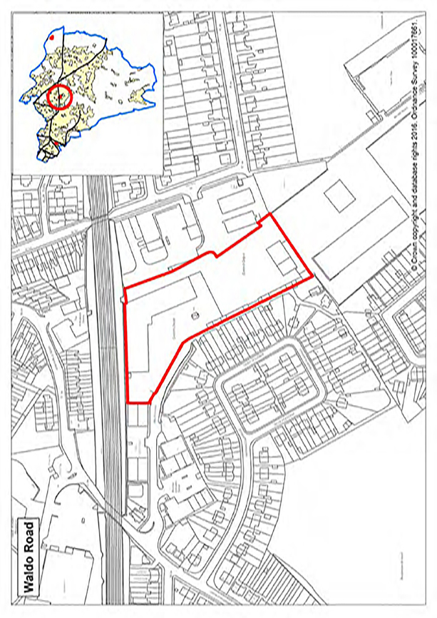
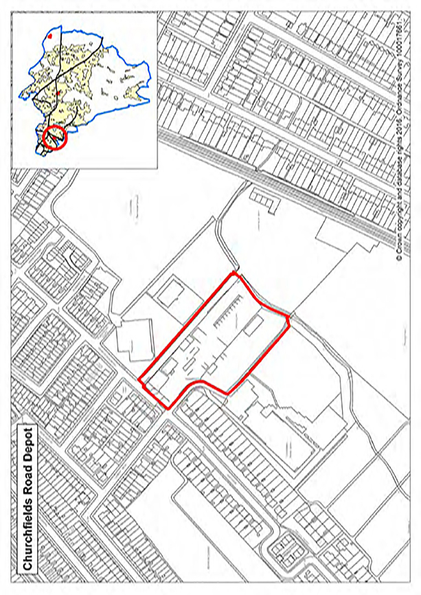
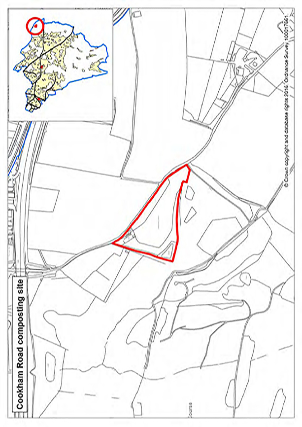
Proposed Monitoring Framework
The proposed monitoring framework for the Local Plan is set out below. It is set out by Local Plan Objectives, targets, and the key policies contributing to the indicator that is being measured. Each target has been developed to be specific, measurable, attainable, realistic and timely, in line with the SMART approach to target setting. The reporting on success against these targets will be presented in the Authority Monitoring Report (AMR), which is to be published online each year. The monitoring framework itself will be kept under regular review through this process to ensure the indicators remain relevant and relate to data which is available to the local authority.
| Objective | IND | Indicator | Target | Target period | Key policies | |
|---|---|---|---|---|---|---|
| 1 | Open Space and the Natural Environment: To manage, protect, and enhance the natural environment by improving the quality of open space and encouraging provision in areas of deficiency and new development. | 1.1 | Change in Green Belt land (ha) | No loss of land for inappropriate development | Annual | Green Belt (GB) |
| 1.2 | Change in Metropolitan Open Land (ha) | No loss of land for inappropriate development | Annual | Metropolitan Open Land (MOL) | ||
| 1.3 | Change in Urban Open Space (ha) | No development contrary to policy | Annual | Urban Open Space (UOS) | ||
| 1.4 | Change in Local Green Space | No loss of land for inappropriate development | Annual | Local Green Space (LGS) | ||
| 2 | Health and Wellbeing: Produce healthier environments and infrastructure to support people in living fuller, longer, healthier and more sustainable lives, and to ensure that new community facilities are appropriately located to provide accessible, effective, and modern services. | 2.1 | % of residential applications where contributions are sought successfully | All relevant applications | Annual | Health and Wellbeing |
| 2.2 | Net additional/improved sport and recreation facilities (School provision and public accessible) | All school development | Annual | Opportunities for Community Facilities Education Facilities |
||
| 3 | Homes: Ensure that there is an appropriate supply of homes to meet the varied needs of the local population and ensure new homes are designed to minimalize environmental impacts and are supported by appropriate social and environmental infrastructure | 3.1 | Provision of new homes | Minimum 641 per annum | Annual | Housing Supply |
| 3.2 | Number of affordable homes | 35% on sites of 11 units or more | Annual | Provision of Affordable Housing | ||
| 3.3 | Number of units of specialist housing for older people | London Plan Annex 5 | Annual | Specialist and Older Persons Accommodation | ||
| 3.4 | Number of developments demonstrating economic, social or environmental benefits | All major developments in/adjacent to renewal areas | Annual | Renewal Areas | ||
| 3.5 | Number of Traveller pitches/plots | To meet identified need | Travellers Accommodation | |||
| 4 | Business, Employment, and the Local Economy: Ensure that there is an appropriate supply of commercial land and range of flexible quality business premises across the borough, and limit the loss of B-class floorspace in designated areas. Appropriate provision of facilities to deliver high quality education and training must also be supported |
4.1 | Change in B-Class floorspace in Strategic Industrial Locations (sqm) | No loss of B-Class floorspace | Annual | Strategic Industrial Locations (SIL) |
| 4.2 | Change in B Class floorspace within locally significant industrial sites (sqm) | No net loss of employment floorspace capacity | Annual | Locally Significant Industrial Sites (LSIS) | ||
| 4.3 | Employment floorspace on previously developed land (sqm) | 100% | Annual | Non-Designated Employment Land | ||
| 4.4 | Change in B1(a) floorspace in Office Clusters (sqm) | No loss of B1(a) floorspace | Annual | Office Clusters (OC) | ||
| 4.5 | % of residential applications where education contributions are sought successfully | All relevant applications | Annual | Education Facilities Health and Wellbeing | ||
| 4.6 | New permanent "Forms of Entry" provided | All FE with permanent permission | Annual | Education Facilities | ||
| 5 | Design and Public Realm: To ensure that new development of all kinds is well designed, safe, energy efficient and complements its surroundings, respecting the existing scale and layout. Road and streets are are clean but uncluttered, with street trees and verges improving their appearance. | 5.1 | Completion of public realm projects | All projects completed to a high | Plan Period | General Design of Development |
| 6 | Town Centres: Encourage safe town centres and a prosperous economy by maintaining and improving neighbourhood centres andparades. | 6.1 | Number of vacant retail units (by centre) | Reduction in number of vacant units | Annual | Metropolitan and Major Town Centres District Centres Local Centres |
| 6.2 | Footfall (by centre) | Maintain or improve | Annual | Bromley, Orpington and Beckenham | ||
| 7 | Built Heritage: To conserve and enhance locally and nationally significant heritage assets and encourage a proactive response to the protection and enhancement of heritage assets. | 7.1 | Number of listed buildings demolished/part demolished | Nil | Annual | Listed Buildings |
| 8 | Transport: To promote and facilitate improvements to public transport links, walking, and cycling that reduces the need to travel by private vehicle and promotes public safety. Improve the management of transport infrastructure to manage the existing transport network and reduce commuting times. | 8.1 | Completion of transport projects (as outlined in IDP) | Complete projects formally named in the IDP document | Plan Period | Safeguarding Land for Transport Improvements |
| 9 | Environmental Challenges: To encourage energy efficiency and promote environmentally acceptable energy generation and use. | 9.1 | Amount of municipal waste arising and managed by type | Reduction in quantity of waste going to landfill, and an increase in household recycling rates | Annual | Planning for Sustainable Waste Management |
| 9.2 | Major applications with Sustainable Urban Drainage Systems, and S106 agreements for drainage and flood risk infrastructure | Improved resilience of infrastructure to cope with potential flooding events | Annual | Reducing Flood Risk | ||
| 9.3 | Number of applications approved for development of contaminated land | Contaminated land remediated | Annual | Contaminated Land | ||
| 9.4 | Major developments meeting and exceeding carbon reduction targets, and monies from the carbon off-setting fund spent on local projects | Reduction in carbon dioxide from new development | Annual | Carbon Reduction | ||
| 9.5 | Capacity of renewable energy installations incorporated into major developments | Increase in renewable energy generation | Annual | Carbon Reduction | ||
| 9.6 | Increased use of decentralised energy networks | Applications creating new decentralised energy networks or connecting to existing networks | Annual | Carbon Reduction |
Transport Infrastructure
Roads
| Scheme | Location/ Ward | Description of Infrastructure project | Relevant Local Plan policy | Rationale | Funding source | Cost (if known) | Lead delivery agent | Delivery partners | Dependencies | Time frame | Source |
|---|---|---|---|---|---|---|---|---|---|---|---|
| Beckenham Road (A234), between Croydon Road and Kent House Road | Penge and Cator | Carry out corridor study | 31 | Congestion issues | LBB | £40K | LBB | 2016-20 | LIP2/3 Congestion Relief programme |
||
| Rail over road bridge pinch points | Shortlands Orpington |
Rail over road bridge pinch points Shortlands and Orpington |
31 | Congestion issues | TBC | £10m+ per scheme | Network Rail | Network Rail and TfL | 2020 | LIP2/3 | |
| A222 between Croydon Road and A20 | Various | Multi-year congestion relief scheme | 31 | Current levels of congestion | LBB | £450k | LBB | TfL | 2016-20 | LIP2/3 | |
| Oakley Road/Bromley Common | Bromley Common and Keston | Realignment of junction | 31 | Congestion relief | TfL | £1m | TfL | TfL | Funding and feasibility | 2016-20 | LIP2/3 |
| A21, Mason's Hill, between Kentish Way and B265 intersection with Hayes Lane and Homesdale Road | Bromley Town | Provision of additional road capacity on the A21 between junction with Westmoreland Road and junction with Crown Lane | 36 | To assist with release of development sites in town centre | TfL/ Developer s106 Planning Obligations/CIL | £21m | TfL | TfL LBB | Feasibility study and business case | 2018-22 | LIP2/3 |
| Bromley, Masons Hill/High Street / Westmoreland Road | Bromley Town | Junction capacity improvements with localised widening to facilitate change of priority between Masons Hill and Westmoreland Road | 36 BTC23 AAP |
To assist with release of development sites in town centre | TfL/ Developer s106 Planning Obligations/ CIL/s278 |
£2.9m | TfL | LBB | Feasibility and business case | 2018-22 | LIP2/3 |
| Crofton Road (A21/A232) / Farnborough Common (A21) |
Farnborough and Crofton | Junction improvements | 31 | Highway network pinch point | TfL | £5m | TfL | LBB | Planning | 2016-20 | LIP2/3 |
| Keston to Biggin Hill accessibility scheme (includes proposed schemes at A233/A232, Keston Mark and A233 Leaves Green Road / Downe Road to Blackness Lane, Keston) |
Darwin | Junction and on-line improvements | 36 | Support the growth strategy for Biggin Hill Airport | TfL | LBB | Planning | 2016-20 | LIP2/3, URS- Biggin Hill study |
||
| Crystal Palace / Anerley Hill feasibility | Crystal Palace | Route and junction improvements | 32 | Capacity and safety issues | TfL | LBB | Feasibility, underground services, and support | 2016-20 | LIP2/3 v |
||
| Chislehurst congestion relief scheme | Chislehurst | Chislehurst congestion relief scheme | 31 | Congestion relief | LBB | TBC | LBB | LBB / Commons Conservators | Feasibility, underground services, and support from the Commons Conservators |
2016-20 | LIP2/3 Congestion Relief Programme |
Parking
| Scheme | Location/ Ward | Description of Infrastructure project | Relevant Local Plan policy | Rationale | Funding source | Cost (if known) | Lead delivery agent | Delivery partners | Dependencies | Time frame | Source |
|---|---|---|---|---|---|---|---|---|---|---|---|
| New car park at Locksbottom | Farnborough and Crofton | Provision of increased parking capacity at the Princess Royal University Hospital site | 30 | Parking capacity deficit at Princess Royal University Hospital | NHS/Bromley/ TfL/developer contributions s106/CIL | £3m | TBC | TBC | Negotiations with South London NHS Trust have begun | 2018-20 | LIP2/3 |
Cycling and walking
| Scheme | Location/ Ward | Description of Infrastructure project | Relevant Local Plan policy | Rationale | Funding source | Cost (if known) | Lead delivery agent | Delivery Partners | Dependencies | Time frame | Source |
|---|---|---|---|---|---|---|---|---|---|---|---|
| Cycle Hubs | Various | Orpington Station, Beckenham Junction, Crystal Palace Station | 31/33 | Encourage new cyclists onto the road network. Health benefits, air quality / environment benefits, reduced traffic congestion | LBB | £80k | LBB | TfL, South Eastern | Stakeholder negotiations | 2016-18 | TfL Borough Cycling Programme/ LBB Cycling Strategy |
| Quietways | Various | Network of two Quietway cycle routes | 31/33 | Encourage new cyclists onto the road network. Health benefits, air quality / environment benefits, reduced traffic congestion |
TfL | Approx £864k |
TfL/Sustrans | LBB, neighbouring boroughs |
Funding, feasibility, and support | 2016-18 | TfL Quietways programme |
| Petts Wood Cycle Bridge | Petts Wood and Knoll | Replacement of footbridge with Cycle / Foot bridge at Petts Wood | 31/33 | Encourage new cyclists onto the road network.Health benefits, air quality / environment benefits, reduced traffic congestion | LBB | £1.3m | TfL/ Network Rail | TBC | Funding | 2019-2021 | LBB Cycling Strategy |
| TfL cycle safety review of junctions (covered under TfL better junctions programme) | Bromley Town, Chelsfield and Pratts Bottom | Schemes to improve safety at A21 Farnborough Way, 100m north of Green Street Green. | 32 | Cycle safety issues identified at junctions | TfL | TBC | TfL/ LBB | TBC | Feasibility studies and identification of budget | TBC | TfL Better Junctions Programme |
| BMX track | Bromley Common and Keston | BMX track built in Norman Park | 20/58 | Increase use of the bicycle for all trips. Increase activity levels in children. | Access Sport, British Cycling, GLA Sport Fund |
£300k | TBC | Access Sport, British Cycling, GLA Sport Fund Funding | Funding | 2018-2020 | TBC |
| Cycle Superhighway (CS6) | Penge and Cator | Extension of Route 6 (Penge to City via Elephant & Castle) | 33 | TfL target to increase cycling by 400% from 2001 baseline by 2026 | TfL | TBC | LBB | TfL BP | Outcome of consultation | 2017-2021 | TfL BP 2011-2015 |
Car Clubs
| Scheme | Location/ Ward | Description of Infrastructure project | Relevant Local Plan policy | Rationale | Funding source | Cost (if known) | Lead delivery agent | Delivery partners | Dependencies | Time frame | Source |
|---|---|---|---|---|---|---|---|---|---|---|---|
| Car clubs | Various | To work with car club operators to develop a network of car clubs in appropriate locations in the Borough | 30 | Car club promotion to reduce congestion | LBB / s106 Planning Obligations |
N/A | LBB | TfL / Car Club operators | Car Club operators choice of locations | On-going | LIP2 |
Buses
| Scheme | Location/ Ward | Description of Infrastructure project | Relevant Local Plan policy | Rationale | Funding source | Cost (if known) | Lead delivery agent | Delivery partners | Dependencies | Time frame | Source |
|---|---|---|---|---|---|---|---|---|---|---|---|
| Measures to reduce bus journey times between Bromley and Canary Wharf, and Bromley and Croydon | Various | None available at present | 35 | Improve bus services from Bromley, encourage mode shift to bu | Developer s106 Planning obligations | TBC | TfL | TBC | Feasibility study, business case | TBC | TfL South SRTP |
| Bus route improvements between Biggin Hill and the rest of the borough | Various | Investigate the possibility of an express bus to improve link | To support the sustainable growth strategy of Biggin Hill Airport | s106 Planning obligations | LBB | TfL | Future funding | In line with phased expansion of Biggin Hill Airport | URS- |
Rail accessibility and station improvement
| Scheme | Location/ Ward | Description of Infrastructure project | Relevant Local Plan policy | Rationale | Funding source | Cost (if known) | Lead delivery agent | Delivery partners | Dependencies | Time frame | Source |
|---|---|---|---|---|---|---|---|---|---|---|---|
| Petts Wood 'Access for All' | Petts Wood and Knoll | Provision of step-free access at station | 33 | Access For All programme allocated based on DfT assessment criteria | Network Rail/ DFT | TBC | Network Rail | Network Rail | N/A | 2017/2019 | DfT |
| Shortlands 'Access for All' | Bromley Town | Provision of step-free access at station | 33 | Access For All programme allocated based on DfT assessment criteria | Network Rail/ DFT | TBC | Network Rail | Network Rail | N/A | 2017-19 | DfT |
| St Mary Cray 'Access for All' | Cray Valley West | Provision of step-free access at station | 33 | Access For All programme allocated based on DfT assessment criteria | Network Rail/ DFT | TBC | Network Rail | Network Rail | N/A | 2017-19 | DfT |
Rail Infrastructure
| Scheme | Location/ Ward | Description of Infrastructure project | Relevant Local Plan policy | Rationale | Funding source | Cost (if known) | Lead delivery agent | Delivery partners | Dependencies | Time frame | Source |
|---|---|---|---|---|---|---|---|---|---|---|---|
| Additional capacity on Elmers End Tramlink branch | Kelsey and Eden park | Construction of stabling and a second platform for trams at Elmers End to allow more trams to run to Croydon town centre | 35 | Allowing more trams to run to Croydon town centre from the Elmers End branch, thus adding capacity | TfL | £39m | TfL | TfL and Network Rail | Funding / Tramlink Dingwall Road Loop extension consultation | 2020-30 | TfL Tram 2030 Strategy |
| Additional capacity on Beckenham Junction Tramlink branch | Copers Cope | Double tracking or additional loops on the Beckenham Junction branch | 35 | Allowing more trams to run on the Beckenham Junction Tramlink Branch | TfL | £28m | TfL | TfL and Network Rail | Funding Scheme detail Tramlink Dingwall Road Loop extension consultation | 2020-30 | TfL Tram 2030 Strategy |
| Extension of Tramlink from Beckenham Junction to Bromley town centre | Copers Cope, Shortlands, Bromley Town | Extension of existing Tramlink alignment terminating at Beckenham Junction to Bromley town centre, potentially utilising existing rail tracks | 36 | Demand for Outer London orbital PT capacity enhancements | TBC | £100m | TBC | Network Rail (depends on route alignment) Not something included within TfL's current strategy. | Engineering feasibility study, organisation of rail services and use of tracks serving Bromley South | 2022-30 | LIP2 |
| Extension of Tramlink to Crystal Palace | Crystal Palace | Extension of Tramlink services to Crystal Palace and the removal of all heavy rail services on the Birkbeck route | 36 | Demand for Outer London orbital PT capacity enhancements | TBC | TBC | TBC | Network Rail (depends on route alignment) Not something included within TfL's current strategy | New turnback facility required at Norwood junction to allow necessary level of service on Gipsy Hill route to be retained | TBC, but long term, beyond 2020. | L&SE RUS (July 2011) |
| DLR extension from Lewisham to Bromley North station | Bromley Town | Use of existing rail route from Bromley North to Grove Park for DLR services extended from Lewisham | 36 | Demand for public transport corridor between Bromley and Canary Wharf | TfL | Unknown | Scheme not included in TfL's current strategy | TfL and Network Rail (depends on rout alignment) | Engineering feasibility study and business case | 2022-30 | LIP2 |
| Bromley South to Victoria additional capacity enhancements | Bromley Town | Shoulder peak lengthening, additional fast services, 12-car outers and additional fast services, grade separation at Herne Hill, | 35 | More capacity needed to avoid worsening crowding - growth likely to be especially strong serving Bromley town centre | Network Rail | TBC | TBC | TBC | Funding and feasibility | TBC but post 2016 | TfL South SRTP |
| Bakerloo line southern extension/ Metroisation | Hayes and Coney Hall | Conversion of Hayes branch for use by LUL services from Elephant & Castle via Lewisham - option to Beckenham Junction also under consideration | Beyond 2030 | Alleviate pressure on routes via London Bridge; provide additional capacity in inner South London; possible capacity relief for Elephant & Castle corridor to Blackfriars | TfL | £3bn confirmed cost for the southern line extension which remains an option for TfL | TfL | Possibly Network Rail (depending on route alignment) A future phase of the Bakerloo extension could see the line extended but the current TfL focus is to Lewisham. Metroisation of services may influence any future phase. | Funding and physical constraints on converting line for use by LUL | TBC, but long term, beyond 2030 | L&SE RUS (July 2011) |
Education New Primary Schools
| Scheme | Location/ Ward | Description of Infrastructure project | Relevant Local Plan policy | Rationale | Funding source | Cost (if known) | Lead delivery agent | Delivery partners | Dependencies | Time frame | Source |
|---|---|---|---|---|---|---|---|---|---|---|---|
| Langley Park Primary | Kelsey and Eden Park | New Primary School - 2FE - Currently open in temporary accommodation | 27/28/29 | Need for school places | Free School | - | Education Funding Agency (EFA) | EFA/Langley Park Academies/ LPSB | - | 2016- | - |
| Bushell Way | Chislehurst | New Primary School - 2FE | 27/28/29 | Need for school places | Free School | - | Education Funding Agency (EFA) | - | - | - | - |
Primary School Expansions
| Scheme | Location/ Ward | Description of Infrastructure project | Relevant Local Plan policy | Rationale | Funding source | Cost (if known) | Lead delivery agent | Delivery partners | Dependencies | Time frame | Source |
|---|---|---|---|---|---|---|---|---|---|---|---|
| St John's CE Primary | Penge and Cator | 1.5 to 2FE First bulge class September 2016 - Feasibility stage | 27 | Need for school places | DfE Basic Need Capital/S106 | £S2.182m | LBB | Aquinas MAT | - | 2016-? | - |
| Stewart Fleming (Pioneer) | Clock House | 2 to 3 FE expansion. 2 bulge classes admitted - Construction | 27 | Need for school places | DfE Basic Need Capital/S106 | £9.006m | LBB | The Pioneer Academy Trust | - | 2018 | - |
| Churchfields | Clock House | 1 to 2FE Expansion - Construction | 27 | Need for school places | DfE Basic Need Capital/S106 | £1.367m | LBB | - | - | 2016 | - |
| James Dixon | Crystal Palace | Possible permanent expansion 2 to 3FE. 2 bulge classes admitted - Feasibility (on hold) | 27/29 | Need for school places | DfE Basic Need Capital/S106 | £0.740m (to date) | LBB | - | - | ? | - |
| Marian Vian | Kelsey and Eden Park | 1 bulge class admitted 2015, 2nd in September 2016. Expansion 3 to 4FE - feasibility | 27 | Need for school places | DfE Basic Need Capital/S106 | £3.009m | LBB | Compass Academy Trust | TBC | - | |
| Wickham Common | Hayes and Coney Hall | 1FE Expansion | 27/29 | Need for school places | DfE Basic Need Capital/S106 | - | LBB | - | - | TBC | - |
| Scotts Park | Bickley | 4 additional classes admitted - planning stage | 27/29 | Need for school places | DfE Basic Need Capital/S106 | £3.468m | LBB | E21 | - | 2017 | - |
| St Georges | Bickley | Now Permanently expanded 1.5 to 2FE - construction | 27 | Need for school places | DfE Basic Need Capital/S106 | £2.192m | LBB | - | - | 2017 | - |
| Parish | Plaistow and Sundridge | Now Permanently expanded 2 to 3FE - construction | 27 | Need for school places | DfE Basic Need Capital/S106 | £3.950m | LBB | Aquinas MAT | - | 2016 | - |
| Farnborough | Farnborough and Crofton | Bulge class 2015 and 2016. Permanently expanding 1 to 2FE - Planning stage | 27 | Need for school places | Basic Need/S106 | £5.093m | LBB | Nexus Education Trust | - | 2017 | - |
| Trinity (Princes Plain) | Bromley Common and Keston | 3 bulge classes. Phased expansion from 2FE to 3FE and then 4FE - Construction | 27 | Need for school places | DfE Basic Need/S106/EFA | £6.537m | LBB | Aquinas MAT/EFA | - | 2016- | - |
| Edgebury | Chislehurst | Permanently expanded 1 to 2FE from September 2016 - Construction | 27/29 | Need for school places | Basic Need | £4.536m | LBB | - | - | 2016 | - |
| Castlecombe | Mottingham and Chislehurst North | To expand 1 to 2FE in KS2 from 2017 - planning stage | 27/29 | Need for school places | Basic Need | £3.862m | LBB | Spring Partnership | - | 2017 | - |
| Leesons | Cray Valley West | Has taken 2 bulge classes. Proposed to expand 1 to 2FE - Planning stage | 27 | Need for school places | DfE Basic Need & 2 Year old Capital | £3.803m | LBB | William Willett Trust | - | 2017 | - |
| Midfield Site | Cray Valley West | Permanently expanded 1 to 2FE - Construction | 27 | Need for school places | DfE Basic Need | £1.703m | LBB | - | - | 2017 | - |
| Poverest | Cray Valley West | Has taken 2 bulge classes. Proposed to expand 1 to 2FE - Planning stage | 27 | Need for school places | DfE Basic Need | £4.772m | LBB | - | - | 2017 | - |
| Oaklands | Cray Valley West | Permanently expanded 1 to 2FE - Construction | 27/29 | Need for school places | DfE Basic Need | £2.970m | LBB | Spring Partnership | - | TBC | - |
| Blenheim | Orpington | Proposed 1 to 2FE expansion - Feasibility stage | 27 | Need for school places | DfE Basic Need | £2.972m | LBB | - | - | TBC | - |
| Oaklands | Biggin Hill | Development to meet PAN - construction stage | 27/29 | Suitability and Condition | DfE Basic Need/CIF? | £7.334m | LBB | - | - | 2016 - | - |
New Secondary Schools
| Scheme | Location/ Ward | Description of Infrastructure project | Relevant Local Plan policy | Rationale | Funding source | Cost (if known) | Lead delivery agent | Delivery partners | Dependencies | Time frame | Source |
|---|---|---|---|---|---|---|---|---|---|---|---|
| Eden Park High School | TBC | New Secondary School - 8FE Pre opening | 28/29 | Need for school places | Free School Capital | EFA | EFA/E21 | - | - | - | |
| Bullers Wood School for Boys - St Hugh's Playing Field | Bickley | 6FE - Pre-opening stage | 28/29 | Need for school places | Free School Capital | EFA | EFA/Bullers Wood School | - | 2017 | - | |
| Bromley UTC -1 Westmoreland Road (SHaW) | Shortlands | 6FE - Pre-opening stage | 28/29 | Need for school places/Diversity of choice | UTC Capital | EFA | EFA, Bromley College, Canterbury Christ Church University, King's College Hospital NHS Trust, Mytime Active, Nuffield Health, Oxleas NHS Foundation Trust of Further & Higher Education | - | 2018 | - | |
| Kentwood Site | Penge and Cator | Potential 4FE | 27/28/29 | Need for school places | EFA | - | - | - | - | - | |
| Turpington Lane Allotments | Bromley Common and Keston | Potential 6-8 FE | 27/28/29 | Need for school places | EFA | - | - | - | - | - | - |
| BET Hayes Lane | Bromley Town | Potential for Primary or secondary | 27/28/29 | Need for school places | EFA | - | - | - | - | - | - |
| Land adjacent to Edgebury Primary | Chislehurst | Potential 8FE | 27/28/29 | Need for school places | EFA | - | - | - | - | - | - |
Secondary School Expansions
| Scheme | Location/ Ward | Description of Infrastructure project | Relevant Local Plan policy | Rationale | Funding source | Cost (if known) | Lead delivery agent | Delivery partners | Dependencies | Time frame | Source |
|---|---|---|---|---|---|---|---|---|---|---|---|
| Chislehurst School for Girls | Chislehurst | Secondary School Expansion | 27 | Need for school places | - | - | - | - | - | - | - |
| Bishop Justus | Bromley Common and Keston | Secondary School expansion - 6 to 8FE - Construction (phase 1) | 27 | Need for school places | Basic Need Capital | - | LBB | Aquinas MAT | - | 2016-19 | - |
| Ravens Wood | Bromley Common and Keston | Secondary School expansion - Feasibility stage | 27 | Need for school places | TBC | TBC | LBB/School | - | - | - | - |
| Darrick Wood | Farnborough and Crofton | Secondary School expansion | 27 | Need for school places | - | - | - | - | - | - | - |
Special Education Facilities
| Scheme | Location/ Ward | Description of Infrastructure project | Relevant Local Plan policy | Rationale | Funding source | Cost (if known) | Lead delivery agent | Delivery partners | Dependencies | Time frame | Source |
|---|---|---|---|---|---|---|---|---|---|---|---|
| BET Hayes Lane | Bromley Town | Special Education Facilities | 27/28/29 | Future need | - | - | - | - | - | - | - |
| Midfield Site | Cray Valley West | Special Education Facilities | 27/28/29 | Future need | - | - | - | - | - | - | - |
| Burwood | Orpington | Special Education Facilities - 1FE Need at KS2 - Planning stage | 27 | Need for places | DfE Basic Need + SEN? | £3.125m | LBB | Beacon Academy Trust/Bromley College | - | 2016 - 18 | - |
| Marjorie McClure | Chislehurst | Special Education Facilities - Suitability and Condition - Pre-feasibility stage | 27 | Suitability and Condition | Priority Schools Building Programme (PSBP) | - | EFA | EFA | - | Post 2016 | - |
Health
| Scheme | Location/ Ward | Description of Infrastructure project | Relevant Local Plan policy | Rationale | Funding source | Cost (if known) | Lead delivery agent | Delivery partners | Dependencies | Time frame | Source |
|---|---|---|---|---|---|---|---|---|---|---|---|
| Health facilities | Bromley Town and various other locations | Bromley Health and Well-being Centre (Capital cost of new health facilities) | 23 BTC AAP BTC1 | Any costs would cover the three year gap in funding for additional population, before central government funding is triggered | TBC | Estimated £8.5m | - | Central Government NHS Bromley Budget S106 Planning Obligations/ CIL) | - | Post 2018-19 (Within 5 years) | Healthy Urban development Unit (HUDU model) Bromley CCG |
Open Space, Parks and Gardens, Sports
| Scheme | Location/ Ward | Description of Infrastructure project | Relevant Local Plan policy | Rationale | Funding source | Cost (if known) | Lead delivery agent | Delivery partners | Dependencies | Time frame | Source |
|---|---|---|---|---|---|---|---|---|---|---|---|
| Upgrading of park playground facilities | Borough wide | Children's playground | 57/58 | Lack of play facilities in certain parts of the borough | TBC -Plus s106 Planning Obligations | - | TLG/LBB | - | Stakeholder support required Developer contributions | TBC | - |
Leisure
| Scheme | Location/ Ward | Description of Infrastructure project | Relevant Local Plan policy | Rationale | Funding source | Cost (if known) | Lead delivery agent | Delivery partners | Dependencies | Time frame | Source |
|---|---|---|---|---|---|---|---|---|---|---|---|
| Cotmandene Regeneration | St. Pauls Cray | New leisure hub offer. Supporting Residential development | 17/20 | Regeneration | Capital | £5.5m | LBB | Development partner | Value of capital asset | 2016-2019 | - |
| Chislehurst Library | Chislehurst | Replacement Library as part of new mixed use development. | 20 | Regeneration | Capital | Est £1m | Milngate | Milngate | N/A | 2016/2019 | - |
Heritage
| Scheme | Location/ Ward | Description of Infrastructure project | Relevant Local Plan policy | Rationale | Funding source | Cost (if known) | Lead delivery agent | Delivery partners | Dependencies | Time frame | Source |
|---|---|---|---|---|---|---|---|---|---|---|---|
| Biggin Hill Heritage Centre | Biggin Hill | New Heritage Centre | 40 | Commemorative Detailed design stage/business planning | S106 Capital HLF Treasury | £4.5m | LBB/Heritage Trust | Heritage Trust HLF | Outcome of Lottery Bid/Libor grant application | 2016/2018 | - |
| Crystal Palace Park | Crystal Palace | Capital works | 15/45 | Regeneration In Train | LBB GLA HLF | £2.4m | LBB | LBB / GLA / HLF /Historic England | N/A | 2016 onwards | - |
Public Realm
| Scheme | Location/ Ward | Description of Infrastructure project | Relevant Local Plan policy | Rationale | Funding source | Cost (if known) | Lead delivery agent | Delivery partners | Dependencies | Time frame | Source |
|---|---|---|---|---|---|---|---|---|---|---|---|
| Beckenham Town Centre Public realm Improvements | Beckenham Town Centre | Public Realm Improvements, Wayfinding and legibility Improvements to Beckenham High Street | 33/37 | Transformational project of the public realm to support the local economy and attract new investment and improvement community safety- Ongoing | TfL/LBB | £4.44m | LBB | TfL / LBB | N/A | 2012-2018 | |
| Bromley Central High Street Improvements | Bromley Town | Public Realm Improvements | BTC AAP | Phase two of the Bromley High Street Improvement programme to encourage footfall and reconfiguring the role of the high street. Concept Design Stage | LBB | £3.8m | LBB | N/A | Project viability | 2015-2018 | LBB |
| Penge Town Centre Public Realm Improvements and Business Support | Penge and Cator | Public Realm Improvements, Improved Wayfinding and legibility, Business Support Programme and shopfront improvement scheme | 15/33/37 | Improving the quality of the current public realm with a focus on community spaces, providing support to existing business in the town centre | New Homes Bonus top-slice funding Committed | £945K | LBB | N/A | N/A | 2015-2017 | LEP New Homes Bonus |
| Orpington Town Centre Public Realm Improvements and Business Support | Orpington | Public Realm Improvements, Business Support | 33/37 | Improving the quality of the public realm and providing market infrastructure in New Homes Bonus and High Street Fund Committed the public square and areas within the Walnuts Shopping Centre, and supporting the market and Orpington First BID company | New Homes Bonus and High Street Fund Committed | £731,000 | LBB | Orpington First BID Co | N/A | 2015-2018 | LEP New Homes Bonus and GLA |
Low Carbon
| Scheme | Location/ Ward | Description of Infrastructure project | Relevant Local Plan policy | Rationale | Funding source | Cost (if known) | Lead delivery agent | Delivery partners | Dependencies | Time frame | Source |
|---|---|---|---|---|---|---|---|---|---|---|---|
| Carbon Offsetting Fund | Various | Carbon Offsetting 124Fund (to reduce carbon which developers can't reduce on-site) | 124 | - | S106 Planning Obligations | - | TBC | - | - | TBC | - |
Energy
| Scheme | Location/ Ward | Description of Infrastructure project | Relevant Local Plan policy | Rationale | Funding source | Cost (if known) | Lead delivery agent | Delivery partners | Dependencies | Time frame | Source |
|---|---|---|---|---|---|---|---|---|---|---|---|
| Combined Heat and Power facilities | Various | Creation of energy networks | 124 | Development of energy networks which both new and existing developments can connect to and expand | S106 Planning Obligations | - | TBC | LBB / | N/A | TBC | - |
Waste and Recycling facilities
| Scheme | Location/ Ward | Description of Infrastructure project | Relevant Local Plan policy | Rationale | Funding source | Cost (if known) | Lead delivery agent | Delivery partners | Dependencies | Time frame | Source |
|---|---|---|---|---|---|---|---|---|---|---|---|
| Waste/recycling facilities | Borough wide / where appropriate | Waste / recycling infrastructure | 114 | Compliance with EU and London Plan policy | TBC | TBC | TBC | LBB / Contractor at time of delivery | - | - | Emerging South London Boroughs Joint Waste Apportionment Technical Pape |
Flood Risk Mitigation
| Scheme | Location/ Ward | Description of Infrastructure project | Relevant Local Plan policy | Rationale | Funding source | Cost (if known) | Lead delivery agent | Delivery partners | Dependencies | Time frame | Source |
|---|---|---|---|---|---|---|---|---|---|---|---|
| Flood Risk Mitigation | Borough wide/where appropriate | Environment Agency identify flood alleviation schemes in the Borough | 115/116 | - | FDGiA, Environment agency / S106 Planning Obligations |
N/A | TBC | Environment Agency/ LBB | TBC | Strategic Flood Risk Assessment, Local Flood Risk Strategy |
Crayfield Business Park, Cray Business Corridor
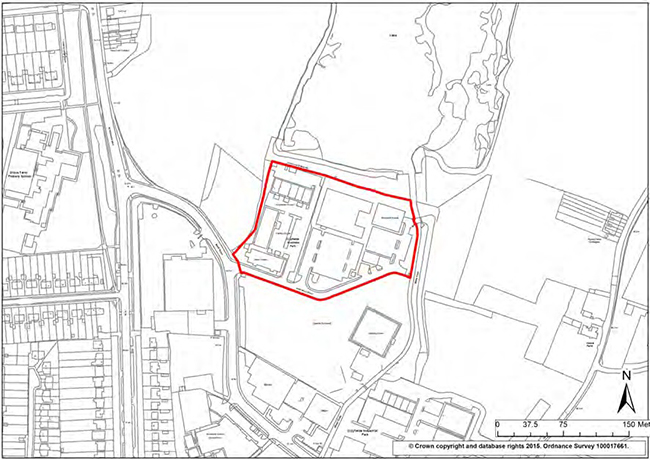
Knoll Rise, Orpington Town Centre
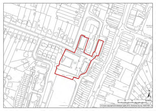
Masons Hill, Bromley Town
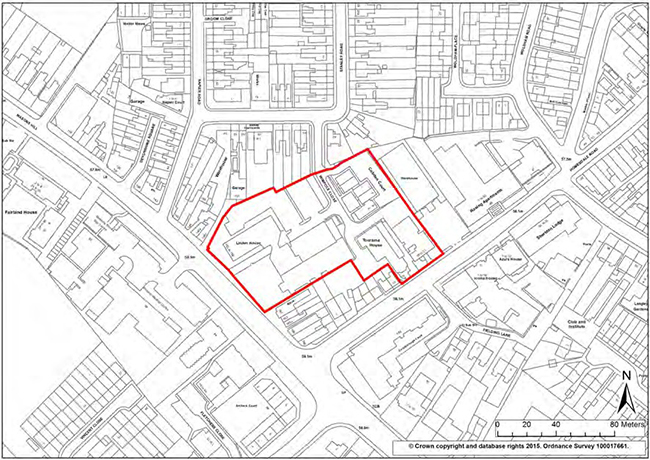
| Living in Bromley | ||
|---|---|---|
| Policy Number |
Policy | Page |
| 1 | Housing Supply | 26 |
| 2 | Provision of Affordable Housing | 33 |
| 3 | Backland and Garden Land Development | 38 |
| 4 | Housing Design | 40 |
| 5 | Parking of Commercial Vehicles | 43 |
| 6 | Residential Extensions | 43 |
| 7 | Accommodation for Family Members | 44 |
| 8 | Side Space | 45 |
| 9 | Residential Conversions | 46 |
| 10 | Conversion of Non-Residential Buildings to Residential Use | 47 |
| 11 | Specialist & Older Peoples Accommodation | 48 |
| 12 | Traveller’s Accommodation | 52 |
| 13 | Renewal Areas | 59 |
| 14 | Development Affecting Renewal Areas | 60 |
| 15 | Crystal Palace Penge & Anerley Renewal Area | 61 |
| 16 | Bromley Common Renewal Area | 62 |
| 17 | Cray Valley Renewal Area | 63 |
| 18 | Mottingham Renewal Area | 64 |
| 19 | Ravensbourne, Plaistow and Sundridge Renewal Area | 65 |
| Supporting Communities | ||
|---|---|---|
| Policy Number |
Policy | Page |
| 20 | Community Facilities | 69 |
| 21 | Opportunities for Community Facilities | 71 |
| 22 | Social Infrastructure in New Developments | 73 |
| 23 | Public Houses | 74 |
| 24 | Allotments and Leisure Gardens | 76 |
| 25 | Burial Space | 76 |
| 26 | Health & Wellbeing | 79 |
| 27 | Education | 84 |
| 28 | Educational Facilities | 86 |
| 29 | Education Site Allocations | 99 |
| Getting Around | ||
|---|---|---|
| Policy number | Policy | Page |
| 30 | Parking | 105 |
| 31 | Relieving congestion | 109 |
| 32 | Road Safety | 110 |
| 33 | Access for All | 111 |
| 34 | Highway Infrastructure Provision | 112 |
| 35 | Transport Investment Priorities | 113 |
| 36 | Safeguarding land for transport investment | 114 |
| Valued Environments | ||
|---|---|---|
| Policy number | Policy | Page |
| 37 | General Design of Development | 117 |
| 38 | Statutory Listed Buildings | 120 |
| 39 | Locally Listed Buildings | 121 |
| 40 | Other Non-Designated Heritage Assets | 121 |
| 41 | Conservation Areas | 122 |
| 42 | Development Adjacent To a Conservation Area | 123 |
| 43 | Trees in Conservation Areas | 123 |
| 44 | Areas of Special Residential Character | 124 |
| 45 | Historic Parks and Gardens | 125 |
| 46 | Ancient Monuments and Archaeology | 126 |
| 47 | Tall & Large Buildings | 127 |
| 48 | Skyline | 128 |
| 49 | The Green Belt | 131 |
| 50 | Metropolitan Open Land | 132 |
| 51 | Dwellings in the Green Belt or on Metropolitan Open Land | 134 |
| 52 | Replacement Residential Dwellings in the Green Belt | 135 |
| 53 | Land Adjoining Green Belt Or Metropolitan Open Land | 135 |
| 54 | South East London Green Chain | 136 |
| 55 | Urban Open Space | 137 |
| 56 | Local Green Space | 138 |
| 57 | Outdoor Recreation and Leisure | 140 |
| 58 | Outdoor Sport, Recreation and Play | 141 |
| 59 | Public Open Space Deficiency | 142 |
| 60 | Public Rights Of Way and Other Recreational Routes | 143 |
| 61 | Horses, Stabling and Riding Facilities | 144 |
| 62 | Agricultural Land | 145 |
| 63 | Development Related To Farm Diversification | 145 |
| 64 | Agricultural Dwellings | 146 |
| 65 | Temporary Agricultural Dwellings | 147 |
| 66 | Occupancy Conditions | 147 |
| 67 | Minerals Workings and Associated Development | 148 |
| 68 | Development and SSSI | 150 |
| 69 | Development and Nature Conservation Sites | 151 |
| 70 | Wildlife Features | 151 |
| 71 | Additional Nature Conservation Sites | 152 |
| 72 | Protected Species | 152 |
| 73 | Development and Trees | 153 |
| 74 | Conservation and Management of Trees and Woodlands | 154 |
| 75 | Hedgerows and Development | 154 |
| 76 | Kent Downs Area of Outstanding Natural Beauty | 155 |
| 77 | Landscape Quality and Character | 155 |
| 78 | Green Corridors | 156 |
| 79 | Biodiversity and Access to Nature | 157 |
| Working in Bromley | ||
|---|---|---|
| Policy number | Policy | Page |
| 80 | Strategic Economic Growth | 162 |
| 81 | Strategic Industrial Locations (SIL) | 164 |
| 82 | Locally Significant Industrial Sites (LSIS) | 167 |
| 83 | Non-Designated Employment Land | 169 |
| 84 | Business Improvement Areas (BIAs) | 170 |
| 85 | Office Clusters | 172 |
| 86 | Office Uses Outside Town Centres (and Office Clusters) | 173 |
| 87 | Home Working | 174 |
| 88 | Hotels | 175 |
| 89 | Telecommunications Development | 176 |
| 90 | Bromley Town Centre Opportunity Area | 180 |
| 91 | Proposals for Main Town Centre Uses | 181 |
| 92 | Metropolitan & Major Town Centres | 183 |
| 93 | Bromley Shopping Centre (formally The Glades) | 184 |
| 94 | District Centres | 185 |
| 95 | Local centres | 186 |
| 96 | Neighbourhood Local Centres, Local Parades and Individual Shops | 187 |
| 97 | Change in Use of Upper Floors | 188 |
| 98 | Restaurants, Pubs & Hot Food Takeaways | 189 |
| 99 | Residential Accommodation | 190 |
| 100 | Markets | 190 |
| 101 | Shopfronts and Security Shutters | 191 |
| 102 | Advertisements | 192 |
| 103 | Biggin Hill SOLDC | 197 |
| 104 | Terminal Area | 197 |
| 105 | West Camp | 198 |
| 106 | South Camp | 199 |
| 107 | Land East of South Camp | 200 |
| 108 | East Camp | 200 |
| 109 | Airport Public Safety | 201 |
| 110 | Noise sensitive Development in Biggin Hill | 202 |
| 111 | Crystal Palace SOLDC | 206 |
| Environmental challenges | ||
|---|---|---|
| Policy number | Policy | Page |
| 112 | Planning for Sustainable Waste Management | 210 |
| 113 | Waste Management in New Development | 213 |
| 114 | New Waste Management Facilities and Extensions and Alterations to Existing Sites | 214 |
| 115 | Reducing Flood risk | 216 |
| 116 | Sustainable Urban Drainage Systems | 218 |
| 117 | Water and Wastewater Infrastructure Capacity | 219 |
| 118 | Contaminated Land | 220 |
| 119 | Noise Pollution | 221 |
| 120 | Air Quality | 223 |
| 121 | Ventilation and Odour Control | 224 |
| 122 | Light Pollution | 225 |
| 123 | Sustainable Design and Construction | 225 |
| 124 | Carbon Dioxide Reduction, Decentralised Energy Networks and Renewable Energy | 227 |
| Delivery and Implementation | ||
|---|---|---|
| Policy number | Policy | Page |
| 125 | Delivery and Implementation of the Local Plan | 230 |
| Glossary and Appendices | ||
|---|---|---|
| Appendix Number | Appendix | Page |
| Glossary | 235 | |
| 10.1 | Housing Trajectory | 254 |
| 10.2 | Housing Site Allocations | 257 |
| 10.3 | Traveller Site Allocations | 276 |
| 10.4 | Education Site Allocations | 284 |
| 10.5 | Parking Standards | 302 |
| 10.6 | Areas of Special Residential Character | 303 |
| 10.7 | Areas of Archeological Significance | 315 |
| 10.8 | Local Green Space | 317 |
| 10.9 | Town Centre Shopping Frontages | 355 |
| 10.1 | Waste Site Allocations | 362 |
| 10.11 | Implementation and Monitoring Framework | 366 |
| 10.12 | Infrastructure Delivery Plan | 373 |
| 10.13 | Office Clusters | 395 |
| 10.14 | List of Local Plan Policies | 398 |
| 10.15 | List of Replaced Development Plan Policies | 405 |
| 10.16 | List of Conservation Areas | 417 |
Schedule of Development Plan policies being replaced by the Local Plan on Adoption
(The entire UDP 2006 is replaced by Local Plan while the Bromley Town Centre Area Action Plan remains, except for the replaced policies listed below)
| Local Plan Sections/ Policies | Saved UDP Policies being replaced | Bromley Town Centre Area Action Plan policies being replaced | |
|---|---|---|---|
| Section 1.2 | About the Local Plan | ||
| Section 1.3 | Vision and Objectives | ||
| Section 1.4 | Spatial Strategy | ||
| Chapter 2 Living in Bromley | |||
| Section 2.1 | Housing | ||
| Policy 1 | Housing Supply | H1 | |
| Appendix 1 | Housing Trajectory | ||
| Appendix 10.2 Housing allocations | |||
| Site 1 | Bromley Civic Centre | OS F | |
| Site 2 | Land adjacent to Bromley North Station | Former OS A (quashed) | |
| Site 3 | The Hill Car Park and adjacent lands | ||
| Site 4 | Gas holder site, Homesdale Road | ||
| Site 5 | Land adjacent to Bickley Station | ||
| Site 6 | Bromley Valley Gym and adjacent land, Chipperfield Road and adjoining land | ||
| Site 7 | Orchard Lodge, William Booth Road | ||
| Site 8 | Bassetts Campus, Broadwater Gardens | ||
| Site 9 | Former Depot, Bruce Grove, Orpington | ||
| Site 10 | West of Bromley High Street and land at Bromley South | OSG and OSJ | |
| Site 11 | 18-44 Homefield Rise, Orpington | ||
| Site 12 | Small Halls, York Rise, Crofton Road | ||
| Site 13 | Banbury House, Bushell Way, Chislehurst | ||
| Policy 2 | Provision of Affordable Housing | H2 and H3 | |
| Policy 3 | Backland and Garden Land Development | H7 part | |
| Policy 4 | Housing Design | H7 and H5 | |
| Policy 5 | Parking of Commercial Vehicles | H13 | |
| Policy 6 | Residential Extensions | H8 | |
| Policy 7 | Accommodation for Family Members | H8 part | |
| Policy 8 | Side Space | H9 | |
| Policy 9 | Residential Conversions | H11 | |
| Policy 10 | Conversion of Non-Residential Buildings to Residential Use | H12 | |
| Policy 11 | Specialist & Older Peoples Accommodation | H4, C6 | |
| Section 2.2 | Travellers | ||
| Policy 12 | Traveller’s Accommodation | H6 | |
| Site 14 | Star Lane | ||
| Site 15 | Old Maidstone Road | ||
| Site 16 | 148 Croydon Road | ||
| Site 17 | Meadow View, Saltbox Hill | ||
| Site 18 | Archies Stables, Cudham Lane North | ||
| Site 19 | Rosedale, Hockenden Lane | ||
| Site 20 | Southview, Trunks Alley | ||
| Site 21 | Mead Green, Layhams Road | ||
| Site 22 | St Joseph's Place, Layhams Road | ||
| Site 23 | Millie's View, Layhams Road | ||
| Site 24 | Keston Mobile Park, Layhams Road | ||
| Site 25 | Keston travelling showmen’s ground, Layhams Road | ||
| Site 26 | Land at junction with Sheepbarn Lane, Layhams Road | ||
| Section 2.3 | Renewal Areas | ||
| Policy 13 | Renewal Areas | ||
| Policy 14 | Development Affecting Renewal Areas | ||
| Policy 15 | Crystal Palace Penge & Anerley Renewal Area | ||
| Policy 16 | Bromley Common Renewal Area | ||
| Policy 17 | Cray Valley Renewal Area | ||
| Policy 18 | Mottingham Renewal Area | ||
| Policy 19 | Ravensbourne, Plaistow and Sundridge Renewal Area | ||
| Section 3.1 | Social infrastructure | ||
| Policy 20 | Community Facilities | C1 and L9 | |
| Policy 21 | Opportunities for Community Facilities | Part S10 | |
| Policy 22 | Social Infrastructure in New Developments | C2 | |
| Policy 23 | Public Houses | ||
| Policy 24 | Allotments and Leisure Gardens | L7 | |
| Policy 25 | Burial Space | ||
| Section 3.2 | Health and wellbeing | ||
| Policy 26 | Health & Wellbeing | C3, C4, C5 and BE4 | |
| Section 3.3 | Education | ||
| Policy 27 | Education | C7 | |
| Policy 28 | Educational Facilities | C7 and C8 | |
| Policy 29 | Education Site Allocations | ||
| Appendix 10.4 | Education site allocations | ||
| Site 27 | James Dixon Primary School | ||
| Site 28 | Kentwood Site, High Street, Penge | ||
| Site 29 | Langley Park School for Boys and Langley Park School for Girls | ||
| Site 30 | 1 Westmoreland Road | OS L | |
| Site 31 | Bromley Education Trust Hayes Lane | ||
| Site 32 | Turpington Lane, Bromley Common | ||
| Site 33 | St Hugh’s Playing Field, Bickley Road | ||
| Site 34 | Scotts Park Primary School | ||
| Site 35 | Castlecombe Primary School and Youth Centre | ||
| Site 36 | Land at Bushell Way, Chislehurst | ||
| Site 37 | Land adjacent to Edgebury Primary School, Slades Drive | ||
| Site 38 | Edgebury Primary School | ||
| Site 39 | Midfield site, Midfield Way (including primary school and alternative provision) | ||
| Site 40 | St Mary Cray Primary School | ||
| Site 41 | Wickham Common Primary School | ||
| Site 42 | Oaklands Primary School | ||
| Chapter 4 Getting Around | |||
| Section 4.1 | |||
| Policy 30 | Parking | T3 and T17 | |
| Appendix 10.5 | Parking standards | ||
| Policy 31 | Relieving congestion | T1, T2, T15 | |
| Policy 32 | Road Safety | T18 | |
| Policy 33 | Access for All | T5, T6, T7, T8, T9, T10 and BE4 | |
| Policy 34 | Highway Infrastructure Provision | T5, T11,T12, T13 | |
| Policy 35 | Transport Investment Priorities | ||
| Policy 36 | Safeguarding Land for Transport Improvements | Schedule of Proposal Sites | |
| Chapter 5 Valued Environments | |||
| Section 5.1 | Built Heritage | ||
| Policy 37 | General Design of Development | BE1 | |
| Policy 38 | Statutory Listed Buildings | BE8, BE9 | |
| Policy 39 | Locally Listed Buildings | BE10 | |
| Policy 40 | Other Non-Designated Heritage Assets | ||
| Policy 41 | Conservation Areas | BE11, BE12 | |
| Policy 42 | Development Adjacent To a Conservation Area | BE13 | |
| Policy 43 | Trees in Conservation Areas | BE14 | |
| Policy 44 | Areas of Special Residential Character | H10 | |
| Appendix 10.6 | Areas of Special Residential Character | Appendix I | |
| Policy 45 | Historic Parks and Gardens | BE15 | |
| Policy 46 | Ancient Monuments and Archaeology | BE16 | |
| Appendix 10.7 | Areas of Archaeological Significance | Appendix IV | |
| Policy 47 | Tall & Large Buildings | BE17 | |
| Policy 48 | Skyline | B18 | |
| Section 5.2 | Open and natural space | ||
| Policy 49 | The Green Belt | G1 | |
| Policy 50 | Metropolitan Open Land | G2 | |
| Policy 51 | Dwellings in the Green Belt or on Metropolitan Open Land | G4 | |
| Policy 52 | Replacement Residential Dwellings in the Green Belt | G5 | |
| Policy 53 | Land Adjoining Green Belt Or Metropolitan Open Land | G6 | |
| Policy 54 | South East London Green Chain | G7 | |
| Policy 55 | Urban Open Space | G8 | |
| Policy 56 | Local Green Space | ||
| Appendix 10.8 | Local Green Space sites | ||
| Site 43 | Alexandra Recreation Ground, Alexandra Road, Penge | ||
| Site 44 | Beckenham Green, High Street, Albemarle Road and St. George's Road, Beckenham | ||
| Site 45 | Bromley Palace Park, Rochester Avenue, Bromley | ||
| Site 46 | Bull Lane allotments | ||
| Site 47 | Cator Park | ||
| Site 48 | Chislehurst Recreation Ground, Walden Recreation Ground, Whytes Wood and Walden Woods, Empress Drive/Victoria Road, Chislehurst | ||
| Site 49 | College Green and Slip, West Street, Bromley | ||
| Site 50 | Dorset Road Allotments, Dorset Road, Elmers End | ||
| Site 51 | Downe Orchard | ||
| Site 52 | Frankswood Amenity Green, Junction of Frankswood Avenue/Lakeswood Road/Crescent Drive, Petts Wood and Knoll | ||
| Site 53 | Havelock Recreation Ground, Homesdale Road, Bromley | ||
| Site 54 | Hollydale Open Space, Kemble Drive, Beverley Drive and Lakeside Drive, Bromley | ||
| Site 55 | High Broom Wood, South Eden Park Road, West Wickham | ||
| Site 56 | Hoblingwell Wood and Recreation Ground, Leesons Hill, St Paul’s Cray | ||
| Site 57 | Kelsey Park, Manor Way, Beckenham | ||
| Site 58 | Kingswood Glen, South Hill Road and Kingswood Avenue, Shortlands | ||
| Site 59 | Library Green and Church House Gardens , Bromley High Street ,Glassmill Lane and Church Road, Bromley | ||
| Site 60 | Royston Field | ||
| Site 61 | Martins Hill, Off Church Road, Bromley | ||
| Site 62 | Queens Gardens, Kentish Way, Bromley | ||
| Site 63 | Queens Mead Recreation Ground, Queens Mead Road and Glassmill Lane, Bromley | ||
| Site 64 | South Hill Wood, Westmoreland Road and Tootswood Road, Bromley | ||
| Site 65 | Turpington Lane Allotments, Bromley Common | ||
| Site 66 | Tugmutton Common and Farnborough Recreation Ground, Starts Hill Road, Farnborough | ||
| Site 67 | Whitehall Recreation Ground, Southlands Road and Cowper Road, Bromley | ||
| Policy 57 | Outdoor Recreation and Leisure | L1 | |
| Policy 58 | Outdoor Sport, Recreation and Play | L6 (part) | |
| Policy 59 | Public Open Space Deficiency | L8 | |
| Policy 60 | Public Rights Of Way and Other Recreational Routes | L2 | |
| Policy 61 | Horses, Stabling and Riding Facilities | L3, L4 | |
| Policy 62 | Agricultural Land | G9 | |
| Policy 63 | Development Related To Farm Diversification | G10 | |
| Policy 64 | Agricultural Dwellings | G11 | |
| Policy 65 | Temporary Agricultural Dwellings | G12 | |
| Policy 66 | Occupancy Conditions | G13 | |
| Policy 67 | Minerals Workings and Associated Development | G14, G15 | |
| Section 5.3 | Nature conservation and development | ||
| Policy 68 | Development and SSSI | NE1 | |
| Policy 69 | Development and Nature Conservation Sites | NE2 | |
| Policy 70 | Wildlife Features | NE3 | |
| Policy 71 | Additional Nature Conservation Sites | NE4 | |
| Policy 72 | Protected Species | NE5 | |
| Policy 73 | Development and Trees | NE7 | |
| Policy 74 | Conservation and Management of Trees and Woodlands | NE8 | |
| Policy 75 | Hedgerows and Development | NE9 | |
| Policy 76 | Kent Downs Area of Outstanding Natural Beauty | NE11 | |
| Policy 77 | Landscape Quality and Character | NE12 | |
| Policy 78 | Green Corridors | NE13 | |
| Policy 79 | Biodiversity and Access to Nature | ||
| Section 6.1 | Business and employment | ||
| Policy 80 | Strategic Economic Growth | ||
| Policy 81 | Strategic Industrial Locations (SIL) | EMP4 | |
| Policy 82 | Locally Significant Industrial Sites (LSIS) | EMP4 | |
| Policy 83 | Non-Designated Employment Land | EMP5 and EMP6 | |
| Policy 84 | Business Improvement Areas (BIAs) | Policy IA2 | |
| Policy 85 | Office Clusters | ||
| Appendix 10.14 | Office Clusters | ||
| Policy 86 | Office Uses Outside Town Centres (and Office Clusters) | EMP1 (part), EMP3 (part) | |
| Policy 87 | Home Working | EMP8 | |
| Policy 88 | Hotels | L10, L11 | |
| Policy 89 | Telecommunications Development | BE22 | |
| Section 6.2 | Town centres | ||
| Policy 90 | Bromley Town Centre Opportunity Area | ||
| Policy 91 | Proposals for Main Town Centre Uses | S7, EMP1 (part) | |
| Policy 92 | Metropolitan & Major Town Centres | S1, S2 | |
| Policy 93 | Bromley Shopping Centre (formally The Glades) | S3 | |
| Policy 94 | District Centres | S1, S2 | |
| Policy 95 | Local Centres | S4 | |
| Policy 96 | Neighbourhood Local Centres, Local Parades and Individual Shops | S4, S5 | |
| Appendix 10.9 | Town Centre Shopping Frontages | Appendix V | |
| Policy 97 | Change in Use of Upper Floors | EMP3 (part) | |
| Policy 98 | Restaurants, Pubs & Hot Food Takeaways | S9 | |
| Policy 99 | Residential Accommodation | S11 | |
| Policy 100 | Markets | S12 | |
| Policy 101 | Shopfronts and Security Shutters | BE19, BE20 | |
| Policy 102 | Advertisements | BE21 | |
| Section 6.3 | Biggin Hill SOLDC | ||
| Policy 103 | Biggin Hill SOLDC | ||
| Appendix 10.10 | Biggin Hill SOLDC Green Belt changes | ||
| Policy 104 | Terminal Area | BH4 | |
| Policy 105 | West Camp | BH4 | |
| Policy 106 | South Camp | BH3 | |
| Policy 107 | Land East of South Camp | BH6 | |
| Policy 108 | East Camp | BH6 | |
| Policy 109 | Airport Public Safety | BH7 | |
| Policy 110 | Noise sensitive Development in Biggin Hill | BH8 | |
| Section 6.4 | Crystal Palace SOLDC | ||
| Policy 111 | Crystal Palace SOLDC | ||
| Chapter 7 Environmental challenges | |||
| Policy 112 | Planning for Sustainable Waste Management | ||
| Appendix 10.11 | Waste Site Allocations | ||
| Policy 113 | Waste Management in New Development | ||
| Policy 114 | New Waste Management Facilities and Extensions and Alterations to Existing Sites | ER2 | |
| Policy 115 | Reducing Flood risk | ||
| Policy 116 | Sustainable Urban Drainage Systems | ||
| Policy 117 | Water and Wastewater Infrastructure Capacity | ||
| Policy 118 | Contaminated Land | ER7 | |
| Policy 119 | Noise Pollution | ||
| Policy 120 | Air Quality | ||
| Policy 121 | Ventilation and Odour Control | ER9 | |
| Policy 122 | Light Pollution | ER10 | |
| Policy 123 | Sustainable Design and Construction | ||
| Policy 124 | Carbon Dioxide Reduction, Decentralised Energy Networks and Renewable Energy | ||
| Policy 125 | Delivery and Implementation of the Local Plan | IMP 1 | |
| Appendix 10.12 | Implementation and monitoring framework | ||
| Appendix 10.13 | Infrastructure Delivery schedule | ||
| Appendix 10.1 | Housing trajectory | ||
| Appendix 10.2 | Housing site allocations | ||
| Appendix 10.3 | Traveller site allocations | ||
| Appendix 10.4 | Education site allocations | ||
| Appendix 10.5 | Parking standards | ||
| Appendix 10.6 | Areas of Special Residential Character | ||
| Appendix 10.7 | Areas of Archaeological Significance | ||
| Appendix 10.8 | Local Green Space | ||
| Appendix 10.9 | Town Centre Shopping Frontages | ||
| Appendix 10.10 | Waste Site Allocations | ||
| Appendix 10.11 | Implementation and monitoring framework | ||
| Appendix 10.12 | Infrastructure Delivery Plan | ||
| Appendix 10.13 | Office Clusters | ||
| Appendix 10.14 | List of policies | ||
| Appendix 10.15 | List of replaced Development Plan policies | ||
| Appendix 10.16 | List of Conservation Areas | ||
| Policies Map Sets 1 and 2 | UDP Proposals Map |
||
| Number | Name |
| 1 | Aldersmead Road, Beckenham |
| 2 | Alexandra Cottages (Parish Lane), Penge |
| 3 | Barnmead Road, Beckenham |
| 4 | Beckenham Place Park |
| 5 | Beckenham Town Centre |
| 6 | Belvedere Road, Anerley |
| 7 | Bickley Park |
| 8 | Biggin Hill RAF Station |
| 9 | The Broadoaks Estate, Bromley |
| 10 | Bromley Common |
| 11 | Bromley Town Centre |
| 12 | Broomhill, Orpington |
| 13 | Cator Road, Sydenham |
| 14 | Chancery Lane, Beckenham |
| 15 | Chelsfield |
| 16 | The Chenies, Petts Wood |
| 17 | Chislehurst |
| 18 | Chislehurst Road, Petts Wood |
| 19 | Crystal Palace Park |
| 20 | Cudham Village |
| 21 | Downe |
| 22 | Downs Hill, Beckenham |
| 23 | Durham Avenue, Bromley |
| 24 | Farnborough Park |
| 25 | Farnborough Village |
| 26 | Garden Road, Bromley |
| 27 | Hayes Village |
| 28 | Keston Park, Farnborough |
| 29 | Keston Village |
| 30 | Manor Way, Beckenham |
| 31 | Mavelstone Road, Bickley |
| 32 | Nash - rural hamlet |
| 33 | The Priory, Orpington |
| 34 | Park Langley, Beckenham |
| 35 | Penge High Street |
| 36 | St. Mary Cray |
| 37 | St. Paul's Cray |
| 38 | Station Square, Petts Wood |
| 39 | Shortlands |
| 40 | Southend Road, Beckenham |
| 41 | Sundridge Avenue, Bromley |
| 42 | Copers Cope |
| 43 | Bromley, Hayes & Keston Commons |
| 44 | Elm Road |