
5.1 Over the Plan period Birmingham will support sustainable growth in housing, retail and employment development to meet the needs of its growing population. The City has traditionally seen new development accommodated through the regeneration, redevelopment and renewal of its urban area with periodic expansion. This approach will continue as the City seeks to accommodate the levels of development set out in Policy PG1 and deliver the overall strategy.
5.2 Delivering the City's growth agenda will require focusing significant development into a number of locations which currently play an important role in providing homes, jobs and supporting facilities.
5.3 Equally the wider City will also see levels of growth reflecting the historic patterns of development and availability of land. This distribution of growth is more dispersed, focused on opportunity sites and key transport corridors which will be considered against the overall strategy and thematic policies within the BDP.
5.4 The network of local centres, housing regeneration sites and Core Employment Areas located across the City will contribute toward the delivery of new homes, retail, office and employment based development that will make, alongside the growth areas, a significant contribution toward the delivery of the overall levels of growth set out in Policy PG1. The network of centres, as set out in Policy TP21, will provide opportunities for a range of new development and improvements to the quality of the environment and accessibility will be encouraged and supported.
5.5 The Core Employment Areas, as set out in Policy TP19, will be retained in employment use and be the focus for economic regeneration and development.
5.6 Housing growth across the City will be supported in locations in line with Policy TP28. The regeneration and renewal of existing housing areas, Policy TP32, will provide a contribution to improving the housing offer and quality of residential environments available within the City.
5.7 The City's administrative boundary is however constrained and there are also limits to the available land within the urban area to accommodate future growth requirements. As a result land will need to be removed from the Green Belt for housing and employment development.
Plan 4 Spatial distribution of growth
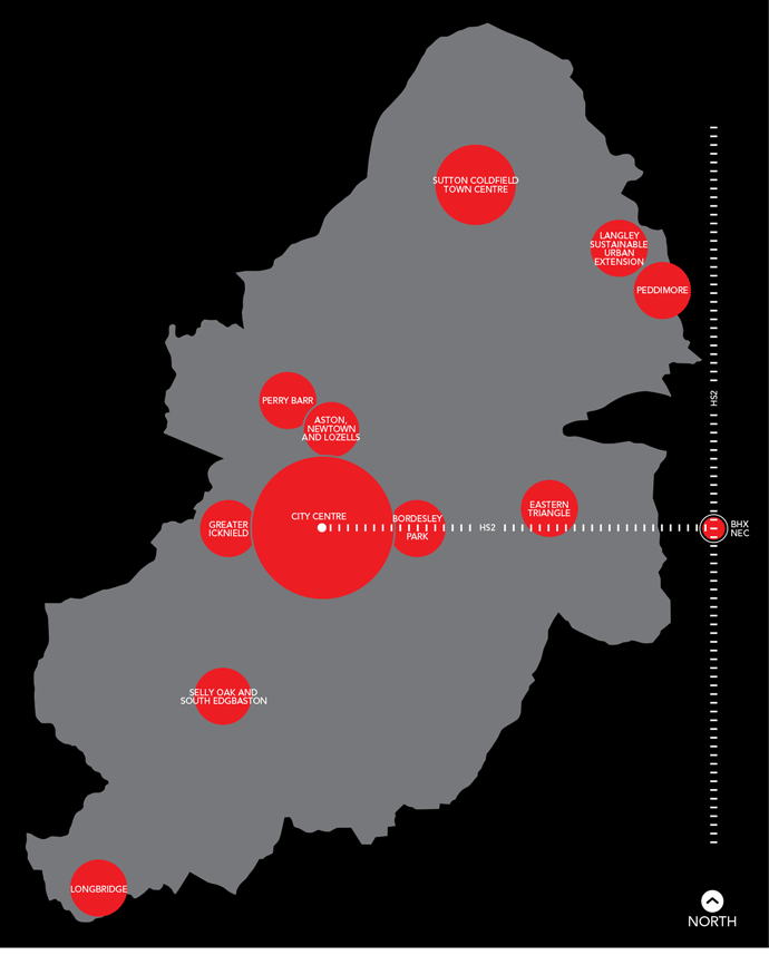
5.8 Across Birmingham there are a number of key areas, as shown in the diagram on page 34, which will make a significant contribution toward delivering the levels of growth in Policy PG1.
5.9 The focus for growth will primarily be upon re-using existing urban land through regeneration, renewal and redevelopment. The City Centre, as the regional centre and key growth point, has established itself as the economic engine of the City and wider region, it will be the focus for significant levels of housing, retail and office development.
5.10 The City has a number of further key areas, outside the City Centre, where there is significant opportunity for growth. These are:
Grand Central at New Street Station
5.11 To meet the needs of the growing population and ensure that sufficient high quality accessible land is available for residential and economic development the City has also planned for the expansion of the urban area through the removal of land from the Green Belt. This will enable the delivery of a planned sustainable urban neighbourhood and a large employment site both located in the northeast of the City.
5.12 The City Council will continue to work proactively in these locations with existing landowners, stakeholders and other agencies to bring forward developments.
5.13 The following section sets out the policies and proposals for those key areas. Each policy is accompanied by a plan which illustrates the proposals. This is provided as a visual aid, and does not form part of the policy.
5.14 Accounting for a third of Birmingham's economic output, supporting over 150,000 jobs, attracting more than £2 billion of shopping expenditure every year and home to over 30,000 people, the City Centre is central to Birmingham's future growth agenda and continuing success in promoting itself as an international City.
5.15 Covering 800 ha the City Centre is positioned as the hub of the City providing local, regional and national transport access, nationally significant visitor attractions and major economic assets.
5.16 In order to strengthen the role of the City on a national and international basis there will be an emphasis on delivering major new investment in retail and office provision. Alongside its important economic and visitor role the City Centre is home to a growing residential population which will continue to expand in the future. This will happen in the context of the wider aspiration of providing a high quality environment and delivering a diverse mix of uses vital to a vibrant centre.
5.17 To support this growth and ensure its ongoing success the traditional City Centre Core will be expanded through five wider areas of change, incorporating significant new office, retail, leisure, residential, civic and cultural uses.
Custard Factory
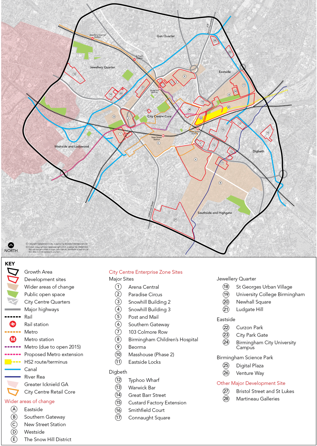
| Policy GA1 City Centre |
| Policy GA1.1 Role and Function |
The City Council will continue to promote the City Centre as the focus for retail, office, residential and leisure activity within the context of the wider aspiration to provide a high quality environment and visitor experience. New development should make a positive contribution to improving the vitality of the City Centre and should aim to improve the overall mix of uses. The City Centre Retail Core, as defined on the Policies Map, will continue to be focused around The Bullring, New Street, Corporation Street, The Mailbox and Grand Central and improvements to the quality of the environment and the shopping experience within this area will be promoted. Appropriate scale retail development will continue to be supported where it complements the existing Retail Core and as part of mixed-use redevelopments throughout the City Centre. Independent retailing will also be supported (see policy TP23). New leisure uses will be promoted within and on the edge of the City Centre Retail Core to support the diversification of the City's offer as a top visitor attraction. The role of the City Centre as a major hub for financial, professional and business services will continue to be supported. The primary focus for additional office development will be within and around the City Centre Core including the Snow Hill District and Westside. The area of Brindleyplace, around the proposed HS2 station in Eastside and along Broad Street and around Five Ways will provide further focus for these uses. Residential development will continue to be supported in the City Centre where it provides well-designed high quality living environments. Developments will need to provide flexible and adaptable accommodation meeting a range of needs including for families. |
| Policy GA1.2 Growth and Wider Areas of Change |
In order for the City Centre to maintain and develop its position as a top visitor destination and driver of the City’s economy, significant new levels of growth will be accommodated. The City Centre has potential to accommodate in the region of 12,800 new homes, 700,000 sq.m. gross of office floorspace and 160,000 sq.m. gross of comparison retail floorspace. The following wider areas of change will be the focus of the proposed growth. Eastside - The ongoing regeneration of this area will enable the City Centre Core to expand eastwards and will require well designed mixed use developments including office, technology, residential, learning and leisure. Any proposals for a HS2 station will need to be integrated into the area creating a world class arrival experience with enhanced connectivity to surrounding areas including Digbeth and the City Centre Core. Southern Gateway - This area will be the focus for the expansion of the City Centre Core southwards through the comprehensive redevelopment of the wholesale markets site delivering a vibrant new destination for the City. Development will be supported that diversifies the City’s offer as a retail and leisure destination including niche retail, improved markets, food and leisure space. Residential development will be supported as part of the future mix of uses with opportunities to stimulate the regeneration of the wider area. The redevelopment will require high quality public spaces and routes to be incorporated with a new public event space creating a centre piece for the area. Integral to creating a new destination will be the creation of exemplar development in terms of its architecture and sustainability credentials, the reinterpretation of the historic moat and manor house, the creation of a gateway to the Digbeth creative quarter and space for a new cultural facility. Development across the wider Southern Gateway will need to address the sustainable management of the River Rea Corridor associated with areas of flood risk and be supported by a range of infrastructure (including green infrastructure)and services, employment opportunities and public spaces and improve connections to Highgate. New Street Southside - Acting as the catalyst for the wider regeneration of the City Centre the redeveloped New Street Station, which opened in 2015, will transform the arrival experience and create new linkages. Selective redevelopment of areas around the station will be encouraged. Westside - Commercial led mixed use developments will be supported in this area including the redevelopment of the Paradise Circus and Arena Central sites. The redevelopment of the Paradise Circus site will require new public spaces, improved pedestrian connections including to the Jewellery Quarter, active frontages, restoration of key views and the enhancement to the setting of listed buildings. The extension of the metro line and other improvements to connectivity within the area will be supported. The redesign of Centenary Square will need to provide improved public transport accessibility and significantly enhanced pedestrian environment alongside a useable event space. The Snow Hill District - The eastern expansion of the central office core around Snow Hill station will be supported through key office and mixed use developments. Connected routes and incidental spaces throughout the district will be promoted to provide a public realm that will encourage new business activity. In particular enhanced pedestrian linkages across Great Charles Street, St Chads Queensway and Lancaster Circus will be central to a transformed pedestrian environment and connections from the City Centre Core into the surrounding areas supported. |
| Policy GA1.3 The Quarters |
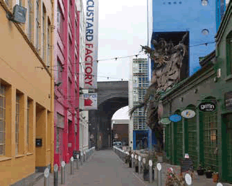
New development must support and strengthen the distinctive character of the areas surrounding the City Centre Core raising their overall quality, offer and accessibility. The City Centre is formed by seven Quarters with the Core at its heart. Within each Quarter varying degrees of change are proposed that relate to the overarching objectives of delivering ambitious growth whilst supporting the distinctive characteristics, communities and environmental assets of each area. The City Centre Core - Providing an exceptional visitor and retail experience with a diverse range of uses set within a high quality environment. Digbeth - Creating a thriving creative and cultural hub with a high quality, exciting and easily accessible environment. Eastside - Maximising its role as an area for learning and technology realising its extensive development opportunities and the integration of any proposals for HS2 station. Gun Quarter - Maintaining the area’s important employment role and industrial activity complemented by a mix of uses around the canal and improved connections to neighbouring areas. The Jewellery Quarter - Creating an urban village supporting the area’s unique heritage with the introduction of an appropriate mix of uses and radically improved connections to the City Centre Core. Southside and Highgate - Supporting the growth of the area’s cultural, entertainment and residential activities and its economic role complemented by high quality public spaces and pedestrian routes. Westside and Ladywood - Creating a vibrant mixed use area combining the visitor, cultural, commercial and residential offer into a dynamic well connected area, which supports development in the Greater Icknield Growth Area. |
5.18 The City Centre has long been central to the economic success of the City. Since the late 1980s the City Centre has established itself as one of the UK’s top centres for professional, financial and business services and as a major visitor destination.
5.19 In the latter part of the 20th century the City Centre was constrained by the Inner Ring Road which was both a physical and psychological barrier to the expansion of the City Centre Core. Much has been done to allow the core to grow beyond this, for instance the lowering of the Inner Ring Road at Paradise Circus facilitating the ICC, Symphony Hall and Brindleyplace; and to the east by the removal of Masshouse Circus linking Eastside to the core.
5.20 Continuing the process of transforming the City Centre, building upon the gains since the 1980's, the future focus will be upon extending and connecting the City Centre Core further beyond its existing boundaries whilst diversifying its activities and supporting economic growth.
5.21 In September 2010 the City Council launched its Big City Plan which sets out the vision for the future transformation of the City Centre over a 20 year period. It identifies the opportunities available in the City Centre and the actions that would need to be taken to deliver long term economic growth and secure a competitive and successful centre for the future. In order to achieve the ambitions and support Birmingham's growth agenda the principles and proposals of the Big City Plan are reflected in the BDP.
5.22 To achieve future growth five wider areas of change (based on the Areas of Transformation in the Big City Plan) have been identified which will create new distinctive places. These are shown on Plan 5. These five areas are based upon existing concentrations of development activity, forming logical extensions of the City Centre Core and making a significant contribution to the city centre's overall growth proposals.
5.23 Central area functions have already stretched west with the development of Brindleyplace, but there are other sites in the vicinity such as Paradise Circus and Arena Central that will provide development potential to transform and integrate Westside. The Eastside area, land around Snow Hill Station and the wholesale market site, all present significant potential to accommodate a range of uses and densities of development expanding the core and diversifying the overall offer. The prospect of the proposed HS2 rail link to the heart of the City will bring a new level of opportunity and investment enhancing Birmingham's role as an international City.
5.24 The new terminus station will need to be integrated into the City Centre and all opportunities to enhance access from and to the surrounding areas, including Digbeth, taken.
5.25 The heart of the City Centre is formed by the City Centre Core. It contains office space for international and national businesses, a varied retail offer catering for a national audience, leisure, cultural and tourist facilities and a transport hub. Located around the outside of the Core are the distinctive Quarters of the City Centre. These Quarters collectively represent the strength of the City Centre, but are an underutilised asset that presents potential to deliver an outstanding and distinctive environment.
5.26 Each of the Quarters have unique qualities which contribute towards the authenticity, diversity and vibrancy of the City Centre. These areas are largely based on historic clusters of related uses and existing physical boundaries.
5.27 By allowing the City Centre Core to grow, and in supporting the distinctive activities and environments of the Quarters this will facilitate the City Centre to change and adapt to meet future needs and to support Birmingham's ability to succeed economically. The quality of the built environment, the canal network and the protection and promotion of the heritage assets will be vital to how future development is brought forward and on-going success of the centre is achieved. This will support the aspirations as set out in the Big City Plan. Additional planning guidance will be brought forward where necessary to provide further detail on the development and growth of the quarters. This includes the proposed Jewellery Quarter Neighbourhood Plan.
| Policy GA1.4 Connectivity | ||||||||||||||
Measures to improve accessibility to and within the City Centre will be supported, including:
Implementation
|
City Centre wayfinding
5.28 The establishment of theEnterprise Zone (EZ) in April 2011, will facilitate long term economic development helping to accelerate delivery of key sites including Paradise Circus and the redevelopment of the wholesale markets site. The LEP has committed significant funding to help deliver the EZ including for infrastructure and site development. The EZ designation will help strengthen Birmingham’s role as a centre for professional, financial and business services and support ongoing diversification of the economy through growth of creative industries. Development on EZ sites is expected to have a strong office/commercial element as part of mixed use or standalone proposals.
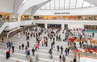
5.29 The City Centre's role as a retail destination will continue to be strengthened with schemes such as the new John Lewis store as part of the redevelopment of New Street Station and refurbishment of the Pallasades transformed into Grand Central. A Retail Strategy will be brought forward by the City Council to set out a vision and a series of actions to deliver a world class retail and leisure offer in the Retail Core. The scale of future comparison retail growth will be less than previously expected reflecting the impact of the recession, growth of internet shopping and changes in spending patterns. For the future the focus will need to be upon diversifying the City Centre's offer and providing new activities and uses which are attractive to a wider audience. The relocation of the wholesale markets presents a significant opportunity to deliver a major new destination strengthening Birmingham's position on the international stage. The growth of the education sector in the city centre is also supported, reflecting the important role of higher and further education.
5.30 Alongside its economic and visitor focus the City Centre is home to over 30,000 people and since early 2000 has seen significant growth in the resident population. This will continue to be supported with new residential schemes, such as the redevelopment at Bristol Street and St Lukes, that will need to deliver both high quality environments and a diverse mix of accommodation.
5.31 The vital role that the City Centre plays as a transport hub is already being strengthened with the £600 million major redevelopment of New Street Station and the £128 million Metro extension. Proposals for HS2 and further investment in public transport will continue to strengthen this role. The Birmingham Curzon HS2 Masterplan has been prepared for the area around the proposed HS2 station and this demonstrates how the benefits of this significant investment can be maximised.
Colmore Row
Plan 5 City Centre Spatial Plan
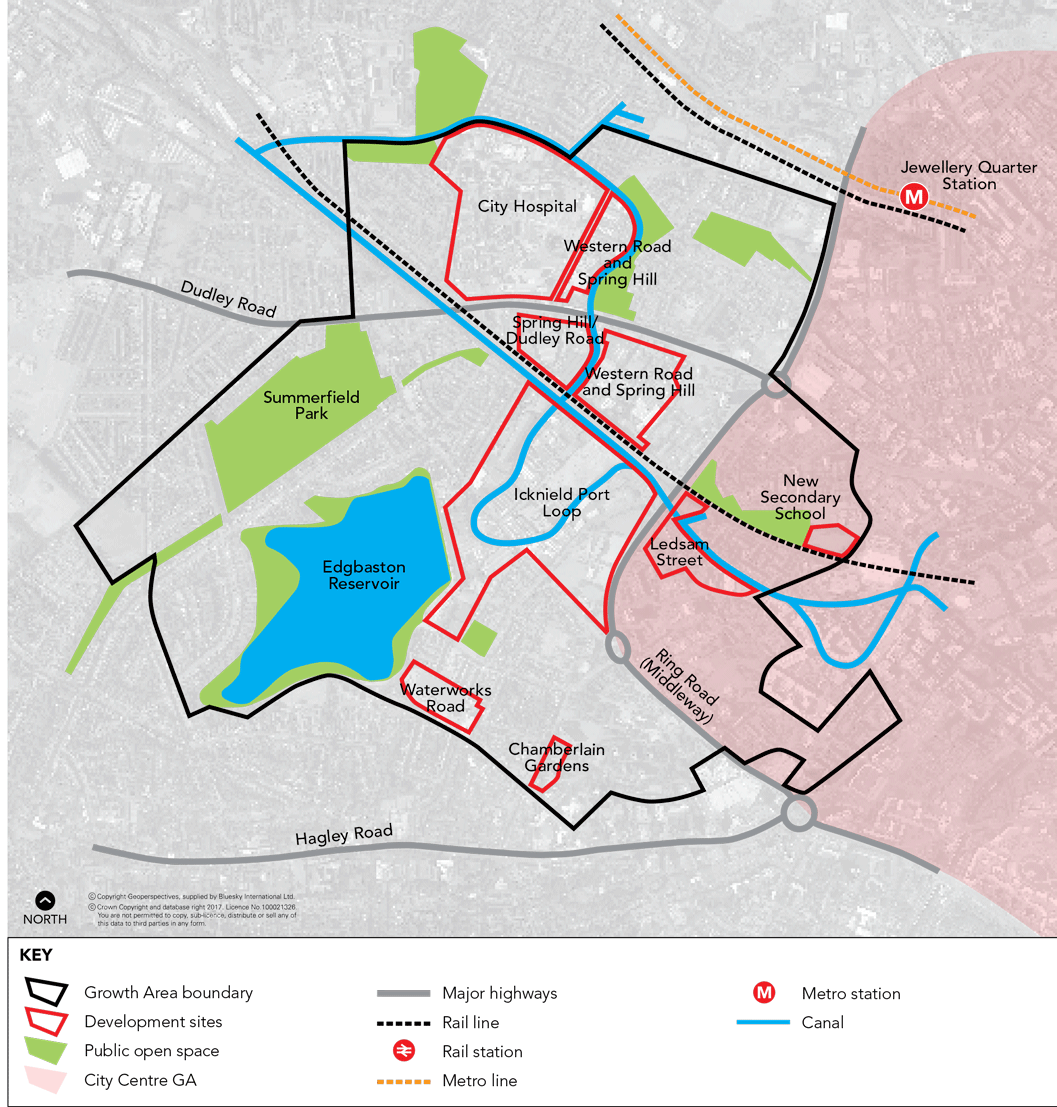
5.32 Greater Icknield occupies a strategically significant location directly to the west of Birmingham’s City Centre. The A457 (Dudley Road/Spring Hill) runs through the area and acts as the main corridor route linking the City Centre to Sandwell/West Bromwich and the motorway network beyond.
5.33 Greater Icknield consists of seven main development sites of largely unused and semiderelict land. The area has the potential to play a major role in meeting the City's challenging growth agenda set out in Policy PG1. It is anticipated that Greater Icknield will provide 3,000 new homes founded upon the principles of creating sustainable neighbourhoods as set out in Policy TP27. New family based models of urban living will be explored and will be supported by a full range of community facilities, local shopping and working opportunities, and better quality streets, parks, squares and gardens. Connections by public transport, walking and cycling will be enhanced including links to the City Centre utilising the canal network and existing primary routes.
| Policy GA2 Greater Icknield | ||||||||||||||
An area of 324 ha bounded by City Road, Winson Green Road, Pitsford Street, Icknield Street and including part of the City Centre and City Hospital, is proposed to ccommodate the delivery of 3,000 new homes. As part of the development local facilities and employment opportunities will be brought forward to support the delivery of a sustainable neighbourhood. The following key sites will support this future growth:
Opportunities for employment growth will be supported with a particular focus on the existing industrial areas at Western Road and Spring Hill as well as Dudley Road local centre. Implementation
|
5.34 The area has a wide range of uses and facilities of varying condition, and is made up of a number of large development sites and opportunities that offer potential for major change.
5.35 Icknield Port Loop is the primary site and enjoys a canalside environment. It has potential for a residential-led mixed use development, taking account of its good accessibility to the City Centre and proximity to existing well established residential neighbourhoods. The site largely comprises an area of former industrial land, a considerable proportion of which is cleared. The area includes a loop of the Birmingham Canal Old Line, which currently has very limited public towpath access. The area also contains Edgbaston Reservoir, one of the most significant areas of open space, which is relatively under-used at present.
5.36 The canal network - Birmingham Main Line and Old Line Canal - is a major feature running through Greater Icknield. Due to limited public access and an isolated environment created by developments backing on to the canal, they are an under-used resource for both leisure and travel. The canals should be protected and enhanced in accordance with Policy TP7 Green Infrastructure Network and Policy TP12 Historic Environment, and their use should be encouraged.
5.37 Part of Dudley Road Local Shopping Centre falls within Greater Icknield and enhancement of the centre, including improvements to the road between City Road and the Ring Road, will be needed as part of future proposals for the area.
5.38 City Hospital is a major hospital providing a wide range of services, including accident and emergency facilities. Following the relocation of most of its services westwards along the A457 to the new Midland Metropolitan Hospital, near Birmingham's boundary with Sandwell Metropolitan Borough Council, most of the site will become available for redevelopment.
5.39 A masterplan for Greater Icknield is being prepared that will be used to guide investment decisions on these major sites and realise the vision of Greater Icknield in delivering the principles of sustainable neighbourhoods. A wide range of social, economic and environmental issues will be addressed through future development.
5.40 Further background information can be found in the evidence base for the Greater Icknield Masterplan.
Plan 6 Greater Icknield Spatial Plan
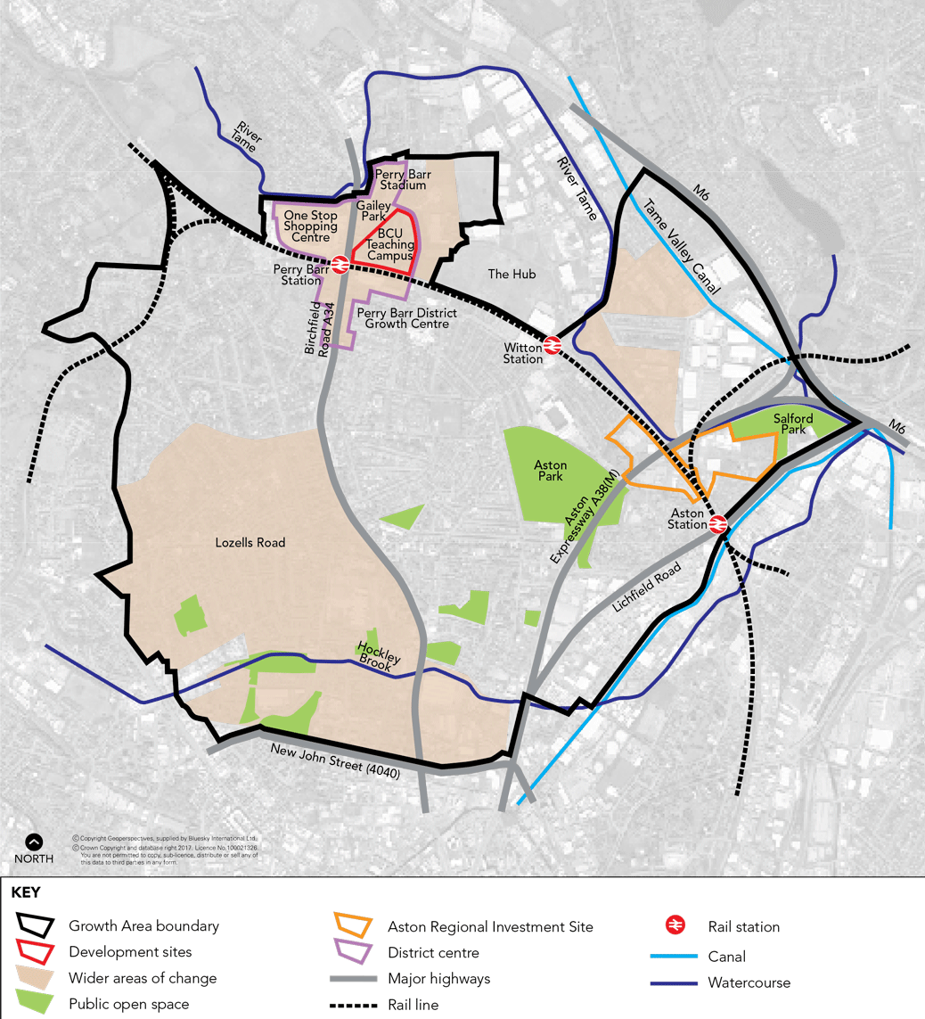
5.41 The Area Action Plan (AAP) for Aston, Newtown and Lozells was adopted by the City Council in July 2012. It covers a large area to the north of the City Centre and includes the neighbourhoods of Aston, Nechells, Perry Barr, Witton, Lozells and Newtown.
5.42 The AAP provides a clear vision and strategy for the regeneration and development of the area and
sets out a comprehensive and co-ordinated approach to shaping employment, housing, retail, and
transport infrastructure.
5.43 Aston, Newtown and Lozells is home to a broad mix of land uses, a range of distinctive local centres and vibrant communities, which make up this diverse and dynamic place. It has excellent transport connections with good access to public transport and the motorway networks. The major arterial routes of the A38 (Aston Expressway), the A34 Birchfield Road and A5127 Lichfield Road run north-south, and the A4540 Ring Road and A4040 Outer Circle run east-west through the area. It is also served by the Birmingham Walsall rail line with stations at Perry Barr, Witton and Aston. The AAP supports a range of cross-cutting aims of the City Council and contributes towards the overarching objectives of the BDP by promoting employment and economic activity and improving environmental quality.
5.44 The majority of the AAP area falls within the 10% most deprived in the country according to the 2010 Indices of Multiple Deprivation. Unemployment and worklessness rates are among the highest in the City, with significant numbers of people experiencing long-term unemployment. Policies in the AAP seek to stimulate new economic activity, create employment opportunities and support business growth.
5.45 The AAP proposes a Regional Investment Site (designated as the Advanced Manufacturing Hub) in East Aston, near Salford Lake, which alone will help to create around 3,000 new jobs. Growth and expansion of Perry Barr/Birchfield District Centre, the protection and regeneration of the Core Employment Areas and new mixed use areas will also result in the creation of new job opportunities.
| Policy GA3 Aston, Newtown and Lozells | ||||||||||||||
An AAP is in place for the area to secure comprehensive regeneration and guide future development over a 15 year period. The AAP has planned for the following levels of growth; over 700 new homes, one Regional Investment Site, up to 10,000 sq.m. gross office space and up to 20,000 sq.m. gross comparison retail. The growth of Perry Barr will be supported in line with Policy TP21. In the case of the Birmingham City University teaching campus there is the potential, due to the relocation of the University, to accommodate growth including a range of local centre uses and housing. High quality design to assist with place-making and a more attractive public realm is essential given the site’s prominent location. Any proposal brought forward for the site should contribute to improving pedestrian linkages, particularly to the One Stop Shopping Centre, Perry Barr rail station and the more traditional retail area to the south at Birchfield Roundabout. This replaces Policy ED1 of the adopted AAP. Implementation
|
5.46 The housing stock in the area has been characterised by areas of large-scale post war housing with high rates of obsolescence, proportionally fewer detached and semi-detached properties, and low home ownership. There is a lack of family housing in the area, evidenced by overcrowding and aspirations for larger properties. The majority of the AAP area was covered by the Birmingham- Sandwell Housing Market Renewal Programme (Urban Living) which came to an end in 2011. There is a need to continue to improve the housing stock in the area and the AAP supports this by identifying sites for new housing and housing regeneration areas.
5.47 Perry Barr/Birchfield is identified as a District Centre growth point in the AAP, and has the potential to accommodate a significant level of retail and office development. Potential exists to diversify the commercial offer (retail and office), whilst also delivering infrastructure improvements, new community facilities and housing growth. Sites with development potential include the Birmingham City University site, One Stop Shopping Centre, Perry Barr Stadium, Gailey Park and the bus depot on Wellhead Lane.
5.48 The Birmingham City University (BCU) teaching campus, covering 8 ha, has a significant presence within the local area and the adopted AAP safeguards the majority of the campus for educational use. However, since the AAP’s examination and subsequent adoption, the University has announced its relocation to Eastside in the City Centre. A regeneration framework will be prepared to ensure that comprehensive development is brought forward that benefits the wider community and contributes towards economic growth within the area. As part of the site is located along the main road frontage, a strong emphasis should be placed on high quality design and depending on the uses brought forward, access improvements may need to be undertaken.
5.49 The AAP Delivery and Implementation Plan sets out the mechanisms, timescales and agencies involved in delivery of the proposals. Its also sets out policies regarding planning obligations and the contributions which will be required to deliver the necessary infrastructure, and other measures, to offset the consequences of development.
Plan 7 Aston, Newtown and Lozells Spatial Plan
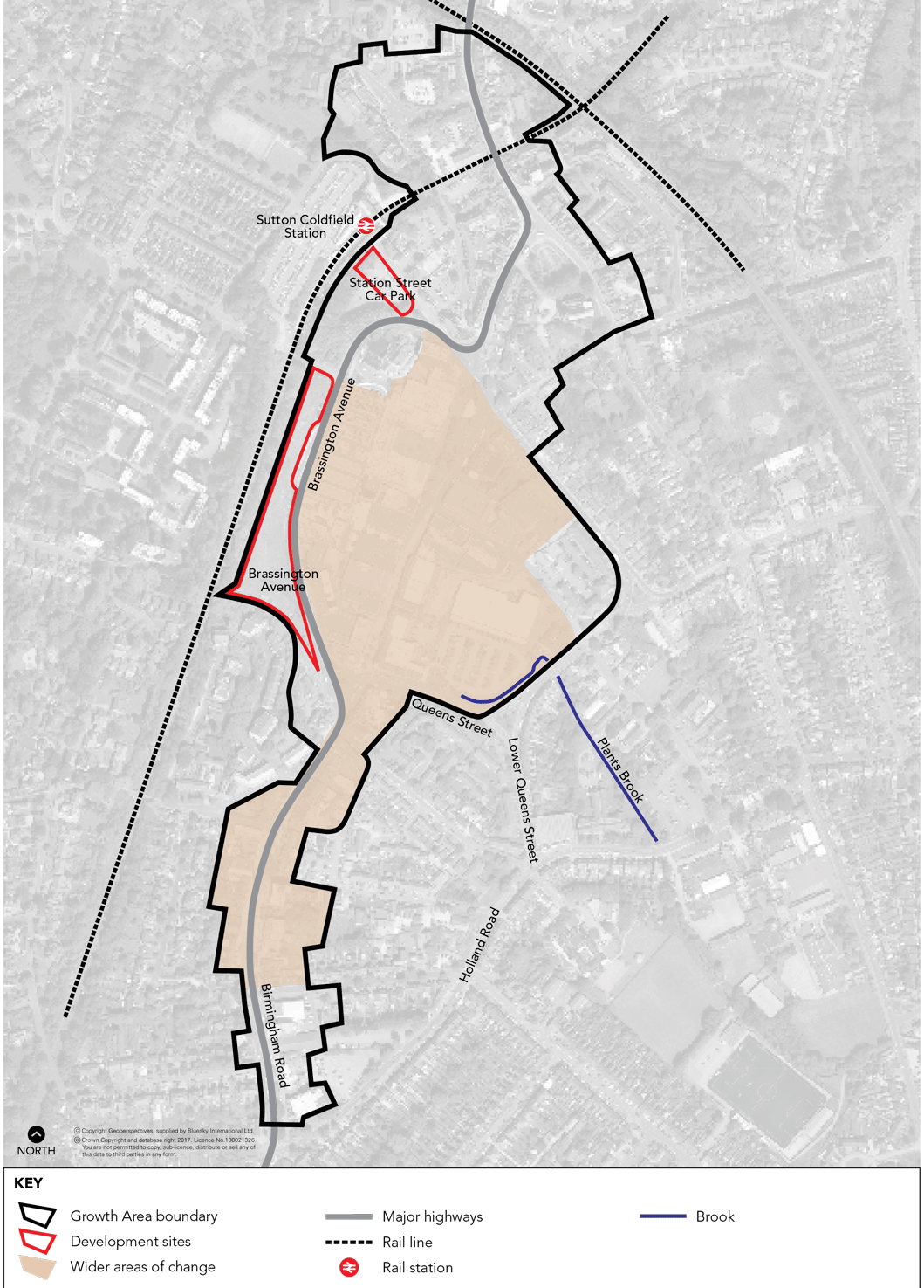
5.50 Sutton Coldfield Town Centre is located to the north of Birmingham and is the largest suburban town centre in the City. It extends from the High Street (A5127) in the north to Birmingham Road to the south, incorporating the train station and Town Hall to the north-west and bounded by Victoria Road and Queen Street to the east and the rail line to the west.
| Policy GA4 Sutton Coldfield Town Centre | ||||||||||||||
The ongoing growth and diversification of uses within Sutton Coldfield Town Centre will be encouraged. In particular:
Implementation
|
5.51 Sutton Coldfield Town Centre will play a leading role in the continued transformation of Birmingham. The limited retail and leisure offer, coupled with increased competition from other shopping destinations, prompted calls for a critical appraisal of the centre, leading to a vision and strategy for its rejuvenation. This is encapsulated in the adopted Sutton Coldfield Town Centre Regeneration Framework SPD (2009).
5.52 The background studies undertaken for the SPD identify that the centre is under performing in relation to its population and local spending power and its position within the wider Birmingham economy. The SPD sets out a longterm vision for the centre, seeking to address deficiencies in existing retail, commercial, leisure and residential provision. It recognises that the competing demands of these various sectors would need to respect the character of the area, whilst making the centre a ‘destination of choice’ rather than just a local shopping centre.
5.53 There are a number of opportunity sites within and around the centre which will accommodate the future growth and help to strengthen its role now and into the future.
5.54 Sutton Coldfield Old Town, which is the historic heart of the town, set within the High Street Conservation Area, is an important part of the centre. The two main challenges which the Old Town faces are centred on promoting commercial sustainable development in historic and listed buildings and seeking to reduce the impact of traffic in the area. A Conservation Area Character Appraisal and Management Plan for the High Street Conservation Area has been adopted which will support the regeneration aspirations of the SPD while at the same time protecting the intrinsic quality of the historic environment.
Plan 8 Sutton Coldfield Town Centre Spatial Plan
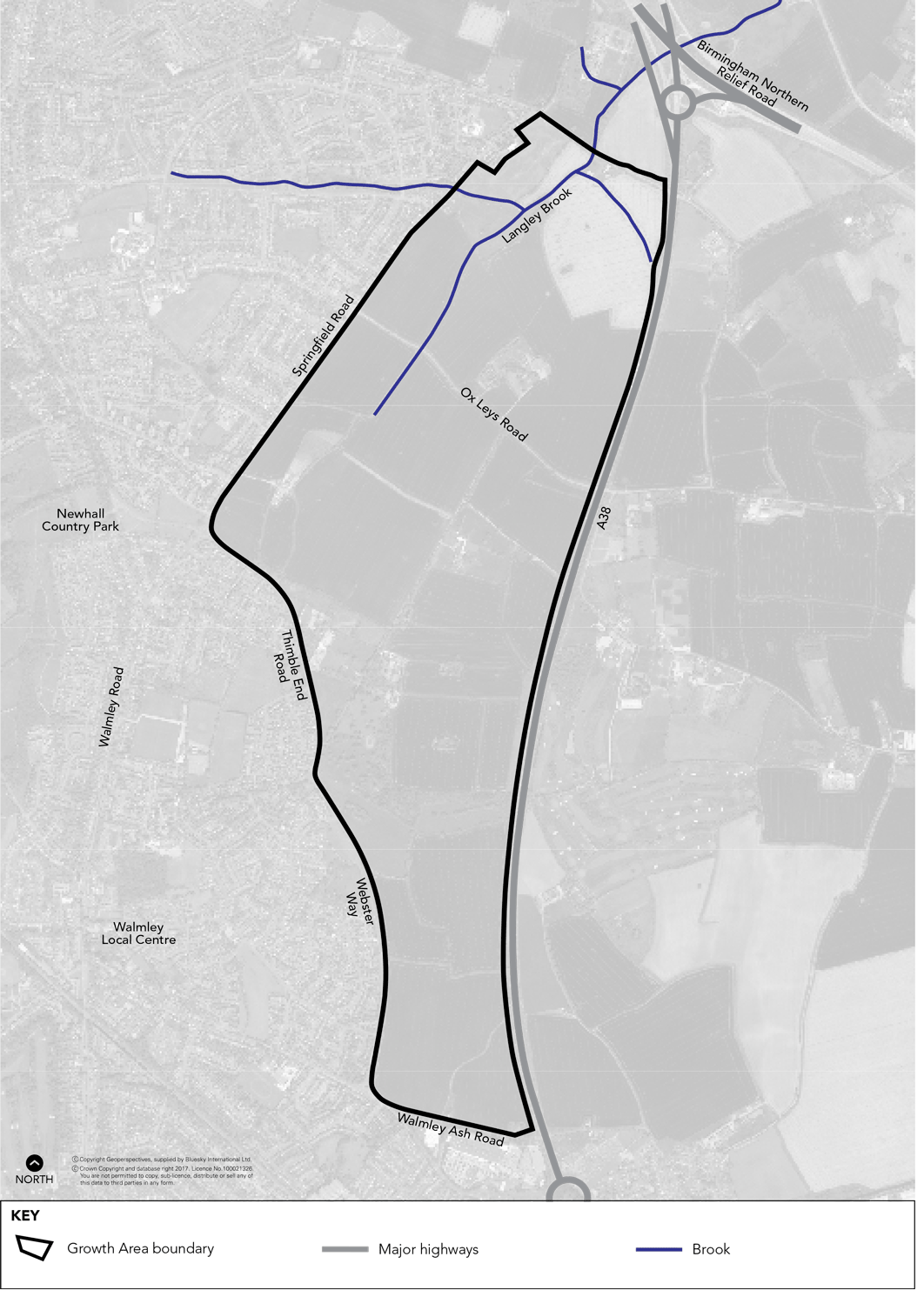
5.55 Land to the west of the A38 at Langley will be developed as a sustainable urban extension to provide for new housing to meet the needs of the City’s growing population. The development will achieve the highest standards of design and sustainability and a network of green spaces including a green corridor to New Hall Valley Country Park. A range of supporting facilities will be provided, including new schools and other services, together with significant improvements to the local highway infrastructure and public transport services.
| Policy GA5 Langley Sustainable Urban Extension | ||||||||||||||
Land to the west of the A38 at Langley will be removed from the Green Belt to provide a sustainable urban extension of approximately 6,000 new homes. The Langley Sustainable Urban Extension will be an exemplar of sustainable development and a destination of choice for families wishing to live in Birmingham. The development will achieve the highest standards of sustainability and design, and provide a range of supporting facilities to help foster a strong sense of community. The creation of wellconnected, integrated and sustainable transport links will be essential to making this a sustainable neighbourhood. Development will also protect and enhance existing heritage assets in the area and provide a network of connected green spaces. The new neighbourhood will provide for a mix of housing sizes, types and tenures, including affordable housing in line with the requirements in Policy TP31. There will, however, be a primary focus on the provision of family housing. As the primary focus of the Langley SUE will be for family housing, this will include areas of residential development at densities averaging around 35dph-40dph. The key design principles of the Langley SUE will be managed through the Masterplan and SPD process. |
||||||||||||||
| Sustainability and design | ||||||||||||||
|
||||||||||||||
| Connectivity | ||||||||||||||
|
||||||||||||||
| Green space and ecology | ||||||||||||||
|
||||||||||||||
| Heritage assets | ||||||||||||||
An Supplementary Planning Document will be prepared to provide detailed guidance on design, phasing and site access to ensure a comprehensive development of the site and relationship with Peddimore (GA6). Implementation
|
5.56 The limited capacity of the urban area to meet the needs of the City’s growing population represents exceptional circumstances which justify the release of land from the Green Belt for housing development.
5.57 Land to the west of theA38 at Langley represents the most sustainable option to accommodate additional housing growth and will have the least impact on the Green Belt.
5.58 The majority of the development area is considered to have low ecological value, with small areas of higher value designated as SLINCS. However, opportunities exist to secure adequate mitigation and compensation as part of the development process. Development should seek to protect and enhance biodiversity and should consider wider links to the Birmingham and Black Country Nature Improvement Area.
5.59 The landscape and visual sensitivity of the majority of the area is judged to be low due to the lack of landscape components and potential development being able to be accommodated in the area without significant loss of landscape features and opportunities for replacement/ mitigation.
5.60 Land west of the A38 is clearly the most sustainable and accessible of all the options considered due to its proximity to existing local facilities. It also has fewer highway constraints and will impact on fewer junctions.
5.61 Heritage assets within the development area include Fox Hollies and its surroundings, including the parkland to its south and the crucible walls to its east; Langley Heath Farm and its setting; Langley Gorse and its setting; Langley Hall and its surroundings, including the moat and two fishponds; former fishponds or millponds on Langley Brook; Springfield Farm and its enclosure; fields around Ash Farm; and Fox Hollies Road. These include designated heritage assets and their settings which will be excluded from development, and heritage assets whose contribution to the character of the place can be enhanced by retention and through design solutions. Archaeological excavation will be required where development affects known, predicted or potential heritage assets of archaeological interest.
New housing
5.62 New Hall Valley Country Park is an important countryside area which penetrates deep into the urban area and is designated as Green Belt. Retaining a green corridor to the Country Park and the wider Green Belt is a key element of the proposed development. At an appropriate time in the future this green corridor should be re-designated as Green Belt.
5.63 Langley’s housing density will average around 35-40 dph, reflecting the site’s urban fringe location adjacent to open countryside. This density responds to the site’s landscape character, environmental qualities and its primary focus on family housing.
5.64 Landowners have indicated their support for the proposal so deliverability is anticipated to be achievable in the plan period. However, market capacity means that it is unlikly that the development will be fully completed within the plan period and capacity will remain for housing development post 2031. It is anticipated that a maximum of 5,000 homes will be developed by 2031 based on a study undertaken
by Peter Brett Associates.
Plan 9 Sustainable Urban Extension Spatial Plan
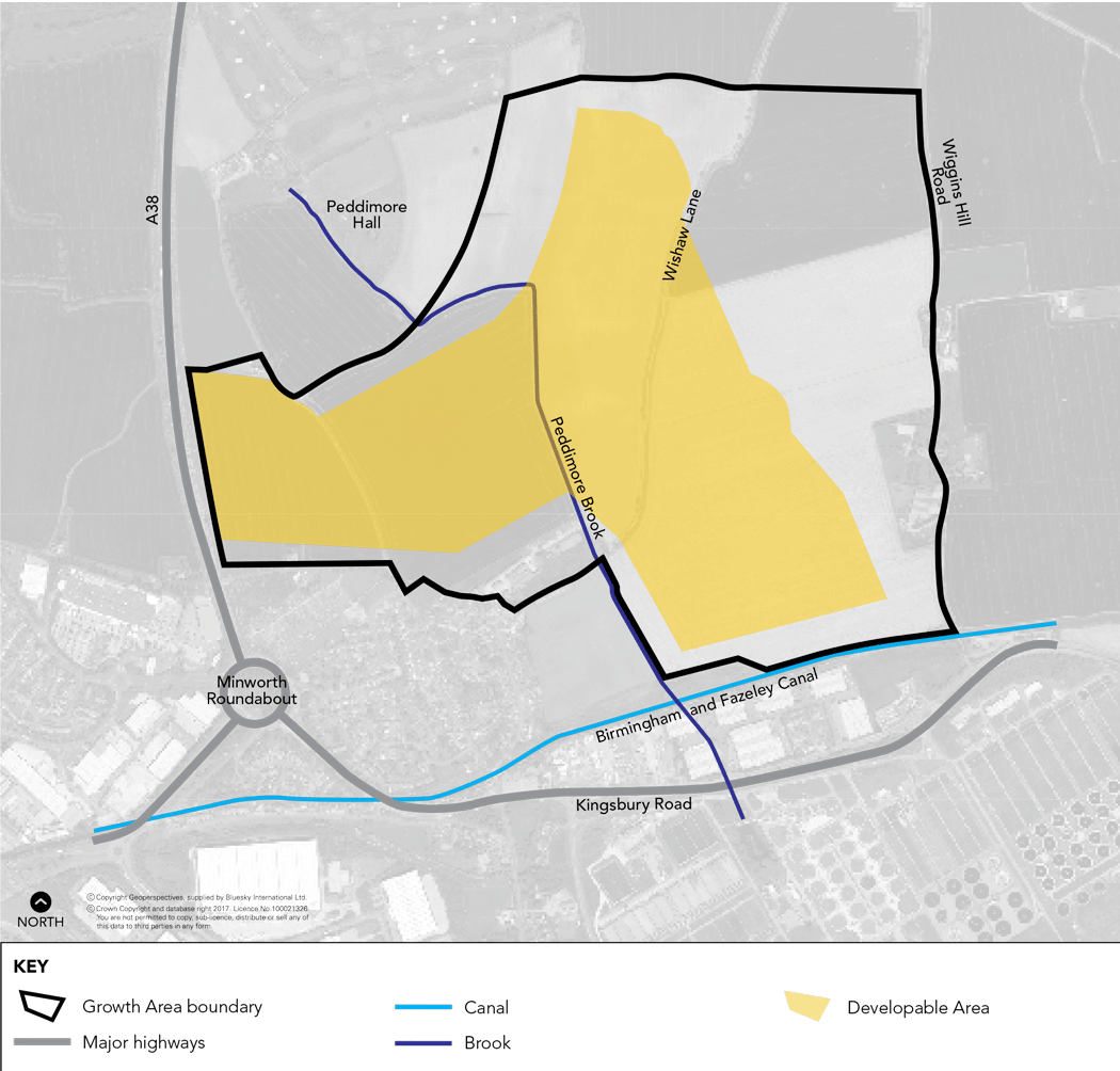
5.65 A high quality employment site of 71 ha is proposed at Peddimore, Minworth. The site which will be
removed from the Green Belt is required to meet the shortfall in best quality employment land. Providing high quality employment land to meet the needs of the expanding growth sectors is essential in supporting the economic prosperity of the City.
5.66 A Study by Warwick Economics and Development found that there is a shortage of high quality land to meet the needs of the expanding advanced manufacturing sector in the City, a proportion of the site is therefore, reserved to meet the needs of this sector. The conclusions of this report are reflected in the findings of the 2012 Employment Land Review (ELR). The ELR shows that there is currently a significant shortfall in the supply of high quality Best Urban employment land. Best Urban sites are large high-quality sites attractive to clients with an international, national and regional choice of location. The ELR
recommends that there is an urgent need to identify new development opportunities in the best urban market.
5.67 Peddimore represents the best opportunity of the Green Belt options considered to accommodate new employment development. The site has low ecological and landscape value and sits within a low lying basin which provides an opportunity to visually contain large scale employment development. The site lies in close proximity to the M42 junction 9 and existing employment areas at Minworth and Kingsbury.
5.68 The shortage of suitable brownfield sites within the urban area to meet the City’s needs for large industrial sites represents the exceptional circumstances justifying the release of Green Belt land for
development.
| Policy GA6 Peddimore | ||||||||||||||
Peddimore will deliver 71 ha of new employment land for B1 (b) Research and Development, B1 (c) Light Industrial, B2 General Industrial and B8 Warehousing and Distribution uses. Office development should remain ancillary to the main industrial use. 40 ha of the site should be safeguarded for B1 (c) or B2 uses. Future development will need to ensure:
Implementation
|
5.69 The moated site at Peddimore Hall is a Scheduled Ancient Monument and its setting is of archaeological importance and will remain in the Green Belt.
5.70 Other heritage assets in the development area include Forge Farm, buildings at Wiggins Hill, the Birmingham and Fazeley Canal and its embankment and bridge, former boundaries in Fox Covert and south of Ramshurst Farm and Linda Vista, ridge and furrow and Wishaw Lane. Archaeological excavation will be required where development affects known, predicted or potential heritage assets of archaeological interest.
Plan 10 Peddimore Spatial Plan
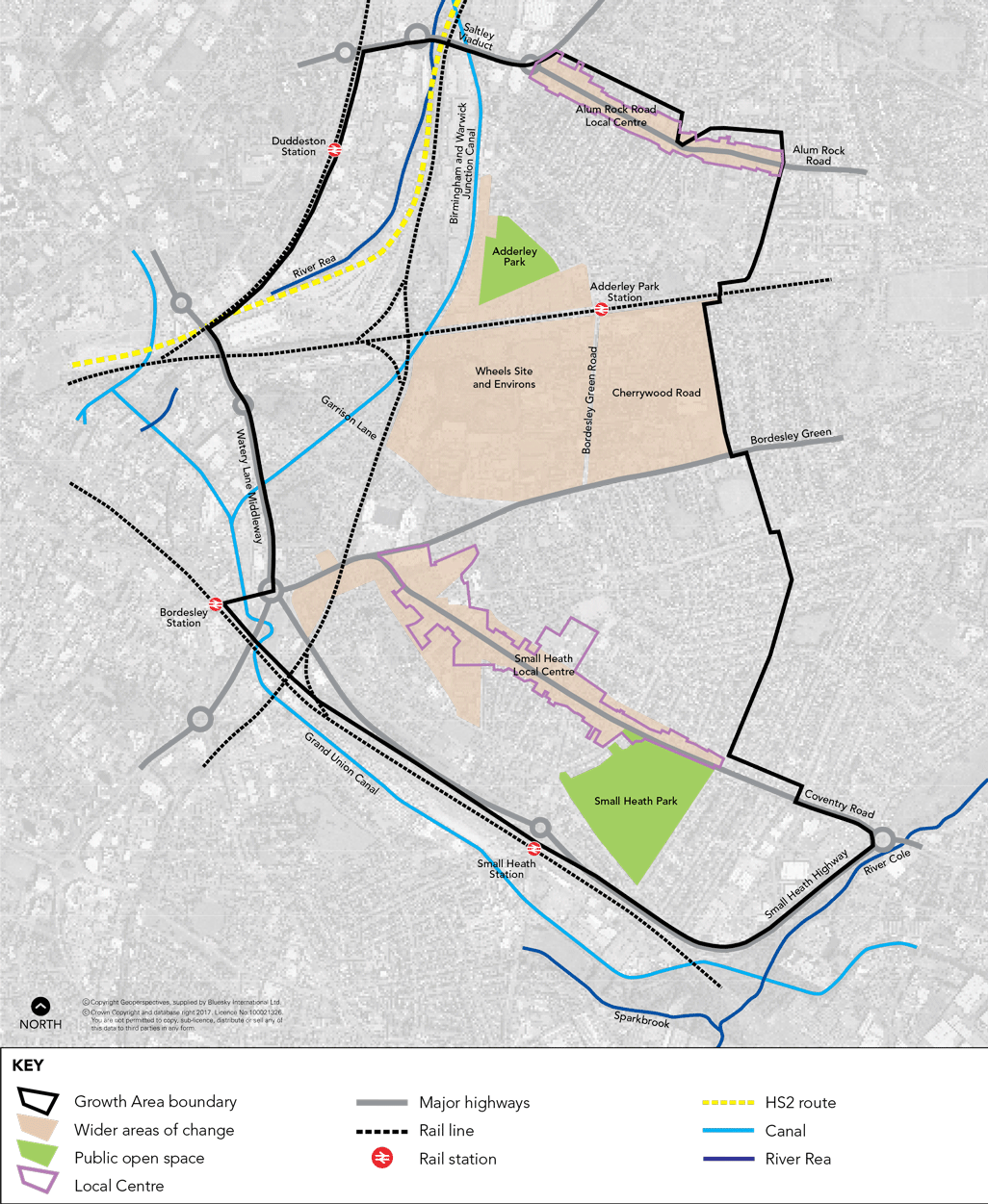
5.71 The Bordesley Park area incorporates the residential and industrial areas to the east of the City Centre. An Area Action Plan (AAP) is being produced to regenerate the area delivering growth within a high quality urban environment. This will have the effect of transforming a part of Birmingham which is currently difficult to access and is lacking in investment, despite its close proximity to the City Centre. The area is bounded by Alum Rock Road Local Centre to the North and the Small Heath Highway to the South.
5.72 The AAP covers an area of around 580 ha to the immediate east of the City Centre, including parts of Washwood Heath, Bordesley Green, Bordesley Village and Small Heath. The development of the AAP provides the opportunity to work with the local community to build upon the area's assets and set out land use proposals and policies to guide development up to 2031. The AAP will promote sustainable growth within the area, including new employment generating activities, housing and enhanced connectivity and an improved environment. The AAP will also act as a tool to promote the area to potential investors and developers.
5.73 The Wheels site and surrounding environs is the major opportunity for transformational change in the area and provides the potential for new employment uses that are integrated with the adjoining areas of Saltley, Bordesley and Small Heath. There are issues with regard to land contamination (the Wheels site is a former landfill site) and infrastructure (mainly transport and access) that will need to be addressed as proposals for the area come forward. The site currently accommodates the Birmingham Wheels Park, providing a range of wheeled sports facilities including speed-skating and gokart tracks and a stock-car racing circuit, which attract users and spectators from across Birmingham, the West Midlands and further afield. Some of the facilities are extensively used by young people from local schools and community groups. The importance of these facilities is recognised and the AAP will need to support their continued operation through equivalent or better quantity and quality replacement provision elsewhere and/or consolidation on site, in conjunction with any redevelopment of the Wheels site. This will include consideration of the catchment area of the participants involved. Appropriate provision will also need to be made for other existing business occupiers of the site.
| Policy GA7 Bordesley Park | ||||||||||||||
An AAP will be prepared for the Bordesley Park area. Future growth and development will be brought forward in line with the policies set out in the AAP. The AAP will plan for the following levels of growth; 750 new homes and up to 3000 new jobs. The AAP covers an area of around 580 ha to the immediate east of the City Centre, including parts of Washwood Heath, Bordesley Green, Bordesley Village and Small Heath. The development of the AAP provides the opportunity to work with the local community to build upon this area’s assets and to establish:
Implementation
|
5.74 Opportunities to improve existing housing and create new housing will be promoted across the area. In particular there is the opportunity for a new residential neighbourhood in the Cherrywood Road area.
5.75 There are thriving local centres at Alum Rock Road and Small Heath and measures to support their continued growth and vitality will be promoted.
5.76 The Camp Hill rail line runs through the AAP area and it is proposed that the line is re-opened to passenger services between Kings Norton and Bordesley and between Bordesley and Tamworth. A connection into Moor Street Station will be provided within the AAP area via new 'chords' at Bordesley. Rapid Transit routes through the area linking the City Centre to the Airport and NEC will also be supported. The HS2 rail line is also proposed to run through part of the area and the City Council is working with HS2 Ltd to minimise and mitigate the impact of the rail line on local residents and businesses both during its construction and future operation.
5.77 The City Council will lead the preparation of the AAP in cooperation with a wide range of partners, agencies, and the local community. As well as setting out land use proposals, the AAP will address viability issues, including those associated with infrastructure and ground conditions.
Plan 11 Bordesley Park Spatial Plan
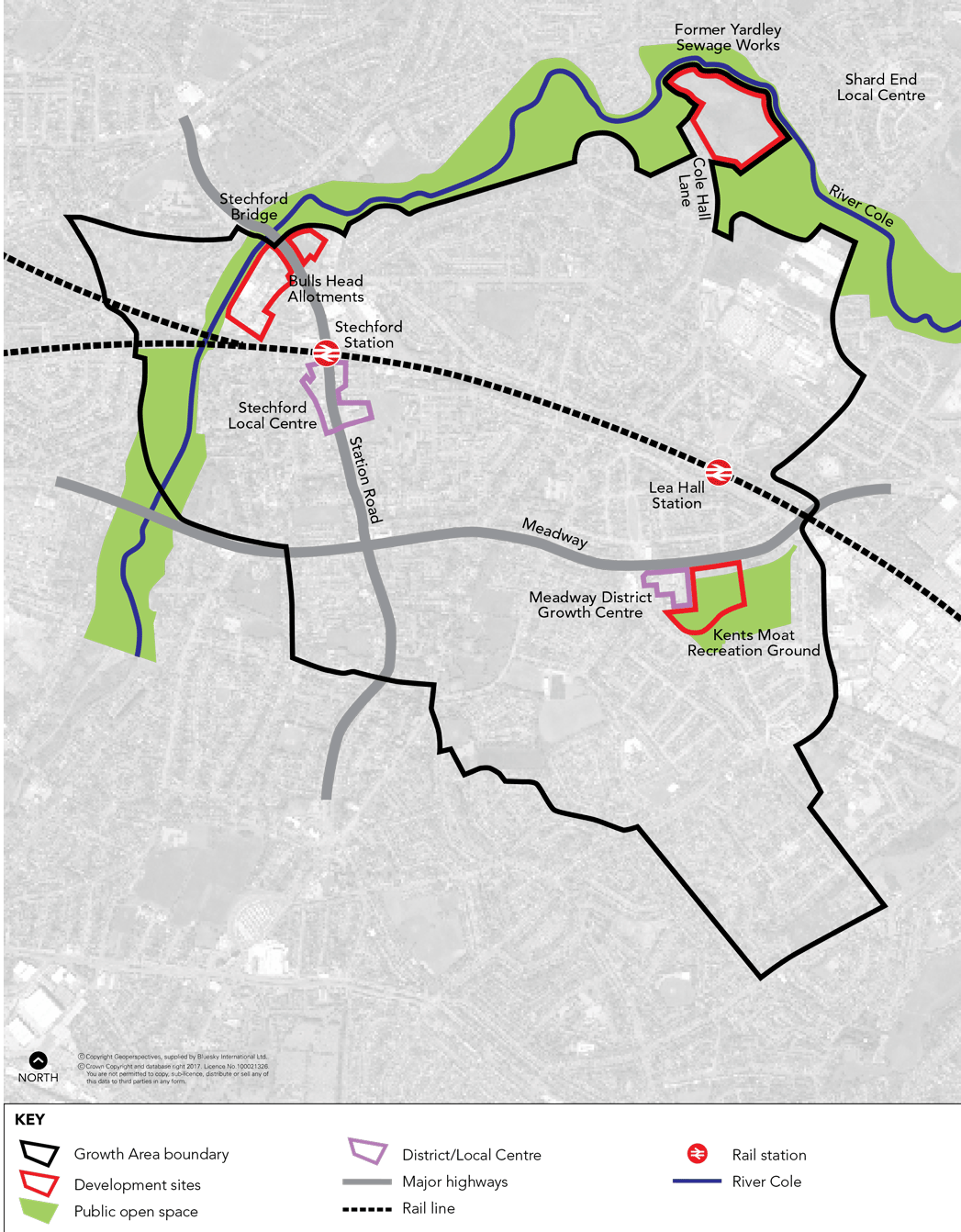
5.78 This area has been an historic focus for development and regeneration, and a number of housing areas have benefitted from redevelopment and significant new investment including Bucklands End and Shard End. The area continues to provide the opportunity for regeneration and economic growth and a number of projects have been identified that will deliver positive change.
These include:
Stechford - an established mixed residential, commercial and local centre with opportunities for a number of sites to be brought forward for housing development.
The Meadway - a local centre with opportunities for redevelopment to provide an improved centre, regeneration and a reconfigured and enhanced area of open space.
Shard End - an area of recent change, but with ongoing potential for new housing including at the site of the former Yardley Sewage Works.
5.79 Each of the identified locations provide significant development opportunities in their own right, but collectively they have the scope to deliver new housing, improved local centres and enhanced community facilities for this part of East Birmingham.
5.80 The wider area is therefore recognised as having considerable development potential with scope to deliver over 1000 new houses. The area benefits from good access to both the City Centre and the Airport/NEC and the proposed interchange station that will serve the HS2 network. A potential rapid transit route is being explored which would link the city centre to the airport and which would run along Bordesley Green and the Meadway.
| Policy GA8 Eastern Triangle | ||||||||||||||
It is proposed that the Eastern Triangle will deliver regeneration and growth for around 1000 new homes. This will be across a number of locations and offering a range of housing types. The potential for the redevelopment of further unsuitable housing stock as well as the more efficient and effective use of existing land and buildings where practical and particularly at locations that are close to local centres, accessible by public transport and on or close to main transport corridors will be explored. In addition, a range of other growth proposals are identified to improve connectivity and transportation across the area including road improvement schemes and investment in public transport. Proposals also include the regeneration and improvement of key local centres and improvements to the wider local environment. At Stechford this will include:
At the Meadway this will include:
At Shard End this will include:
Implementation
|
5.81 The Stechford area is served by both bus and rail services with Stechford rail station providing local rail services to Birmingham City Centre, the NEC and Coventry. There is a mixture of residential, industrial and retail (including Stechford Retail Park) uses in the area. Given its public transport accessibility, there is the potential for Stechford to be the focus for new residential growth.
5.82 The rail station has poor access for those with mobility difficulties, so enhancements will be supported both to the station facilities and environment, as well as improvements to the level of services.
5.83 The area also suffers from road congestion, particularly at the junction of Station Road, Flaxley Road and Iron Lane, and measures to reduce this congestion will be promoted.
5.84 The former Bulls Head Allotments have been declared surplus and provide an immediate opportunity for new residential development. Other residential opportunities in the area will be explored in the longer term including the industrial and commercial area to the south of Stechford Bridge. Any proposals should enhance and provide connections with the River Cole Valley which passes through Stechford and is a significant leisure and nature conservation asset for the area.
5.85 Wider opportunities for housing in the area will also be explored including the potential redevelopment of under used allotments on Burney Lane and Francis Road.
5.86 At Stechford there is the opportunity for new retail development that is within or is well integrated with the local centre and the rail station. Environmental and public realm improvements to the local centre will also be promoted.
5.87 Further planning guidance will be produced to guide future development in the area.
5.88 The Meadway is a focus for regeneration that comprises the redevelopment of the cleared Meadway flats site, the reconfiguration and enhancement of the adjoining Kent's Moat Recreation Ground and proposals for development at the local centre itself. These proposals will include the potential provision for a rapid transit link through the area from the City Centre to the Airport/NEC.
5.89 Improvement of the public realm within the centre and the adjacent Kent's Moat Recreation Ground will be required and improvements will be made to the centre's relationship with and linkages to the recreation ground and adjoining and nearby housing regeneration proposals.
5.90 There is a limited retail offer in East Birmingham and the appropriate growth of both the Meadway and Stechford local centres will be supported to address this shortfall.
5.91 It is proposed to improve the scale and range of retail, service and community facilities at the Meadway Centre (Poolway) to create a new focus for the surrounding community. The centre could accommodate additional comparison floorspace in line with policy and an enhanced convenience retail offer.
5.92 The remodelling of the existing Poolway Centre will be considered to accommodate development that could range from refurbishment and expansion to more comprehensive restructuring. The emphasis will be on creating a more attractive local centre that addresses current design and access issues and provides facilities that are accessible by all modes of travel. A review of the provision and range of services and community facilities will be undertaken.
5.93 Detailed proposals for this area will be developed through the production of further planning guidance.
5.94 Within Shard End targeted redevelopment has delivered a high degree of social and affordable housing to meet immediate re-housing requirements in this area. The former Yardley Sewage Works provides a much larger development opportunity that can deliver a broader range of accommodation that will further improve the attractiveness of the housing offer and regeneration potential of the area.
5.95 The site provides the opportunity to facilitate both the delivery of a new residential area that will help address local regeneration issues (in terms of the diversification and widening of choice within the local housing stock) as well as securing significant environmental works to the Cole Valley that will transform the amenity value of the site along with the access to it and the range of facilities available to the immediate and wider community.
5.96 The site forms part of the former Yardley Sewage Works, which ceased operation in the 1970s. Following decommissioning, only limited remediation was carried out and parts of the site were used for the landfill of demolition and construction waste. Initial investigations of the ground conditions and potential contamination have been undertaken and further investigations will be undertaken as the proposals are advanced.
5.97 The site comprises a generally featureless area to the south of the River Cole. Although included within the Green Belt as part of the Cole Valley, the site currently has restricted access and a limited environmental and recreational value. Principal sporting and recreational sites are located elsewhere in the Cole Valley corridor and are more accessible by local communities (such as the rugby pitches on the opposite side of Cole Hall Lane).
5.98 The River Cole road bridge at Cole Hall Lane has also been recently upgraded to facilitate regeneration opportunities in this area and to encourage better public transport services.
5.99 Development of part of the former sewage works site would seek to secure compensatory measures including opportunities for the improvement of access to the heart of the Cole Valley for the surrounding communities; opportunities to improve facilities (including local centres) within the wider area as part of the delivery of new residential development; and the retention and further enhancement of the most attractive aspects of the Valley. This includes the potential relocation of Yardley and District Rugby Club's clubhouse and changing rooms to their pitches on the opposite side of Cole Hall Lane. The limited value of the Yardley Sewage Works site in terms of the role and function of the Green Belt and the shortage of land for housing in the City, together with the local regeneration benefits and the potential for significant enhancements to the Cole Valley, represent exceptional circumstances which justify the release of the site from the Green Belt.
5.100 Further development guidance for the site will be prepared as necessary to bring forward development. This will include the potential remediation strategy for the site.
New housing
Plan 12 Eastern Triangle Spatial Plan
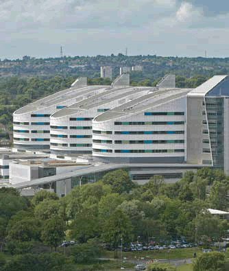
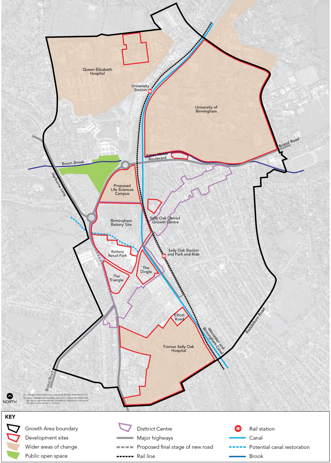
5.101 Selly Oak and South Edgbaston is a strategically important location on the A38 corridor to the south-west of the City Centre. The area includes the Queen Elizabeth Hospital and University of Birmingham, Selly Oak District Centre and adjoining residential areas.
5.102 Selly Oak and South Edgbaston will see significant investment in major strategic sites which will further help to transform the area. The aims are to maximise the potential of the University and Hospitals, promote economic diversification and to secure significant spin off benefits from new development. In particular the area will provide the focus for the clustering of activities associated with medical technology in the Life Sciences sector. This recognises the potential to marry growth in the Life Sciences sector with the unique spatial opportunities offered in this location. This will further enhance the City's future economic competitiveness and attract investment and jobs.
| Policy GA9 Selly Oak and South Edgbaston | ||||||||||||||
The Selly Oak and South Edgbaston area will be promoted for major regeneration and investment and will include: An economic, research and health role, focused around:
The strengthening of Selly Oak District Centre growth point with:
To address the need for regeneration of the centre all developments should contain a mix of uses, make a positive contribution to the diversity and vitality of the centre, and be well integrated with the centre and easily accessible by all modes. Delivery of over 700 new homes at:
Several large sites are available for development in and on the edge of the centre to support this growth:
Future development across the area will need to be supported by and where necessary contribute toward infrastructure including:
Implementation
|
Why we have taken this approach
5.103 There is around 35 ha of vacant land/buildings available for development including the former Birmingham Battery site, other sites in Selly Oak District Centre growth point and the former Selly Oak hospital to deliver the growth and regeneration aspirations. In addition there is potential for significant investment in the existing hospital and university campuses. The area is expected to make a significant contribution to the City's needs for new employment providing around 3,000 new jobs in the Biomedical and Life Sciences sector with further significant job creation in the office, education, retail and healthcare sectors. Opportunities for residential development in the area will provide over 700 new homes.
5.104 The Queen Elizabeth Hospital offers state of the art clinical facilities and has established a growing regional and national role. The proximity of the University with its Medical School has enabled strong partnerships to develop between academics and clinicians. The area is already home to extensive clinical research and many successful companies in the medical technology/Life Sciences sector. The proposed Life Sciences Campus will benefit from colocation with the University and Hospitals and will build on the successes in this field providing a basis for further growth in high value jobs.
The Queen Elizabeth Hospital
5.105 Selly Oak District Centre growth point straddles the Bristol Road, and contains retail warehousing, a foodstore and numerous smaller shops, many providing for the needs of the local student population. However, the centre has been declining as a comparison retail destination, and is in need of investment to improve the diversity, vitality and viability of retail offer and measures to address congestion through the centre and improve the quality of the environment and public realm. The development of key sites will help to address these issues.
5.106 Further investment in the University of Birmingham will be encouraged to ensure it can maintain its role as one of the premier educational establishments in the country for higher education, research and development, and supporting activities.
5.107 The new Queen Elizabeth (QE) Hospital is a facility of both regional and national importance. Also the wider South Edgbaston area is the focus of an emerging healthcare quarter with numerous clinics and hospitals. Within the QE campus there are opportunities for further new healthcare developments including new hospitals that build on the area's success.
5.108 Extensive infrastructure and environmental improvements will be needed to support this level of new development and the policy seeks to ensure that all development contributes to these.
5.109 Finally the policy seeks to address some of the problems faced by residential areas and make Selly Oak/Bournbrook an attractive, balanced and sustainable residential community. The policies in this plan will be supported by other measures to address these issues including an Article 4 Direction and the Student Accommodation SPD.
5.110 A SPD is being prepared for Selly Oak/South Edgbaston that will be used to guide investment decisions on the major sites and realise the vision for the area.
5.111 The City Council will work with the private sector including key landowners such as the University of Birmingham, University Hospitals Trust and Sainsbury's to deliver this policy.
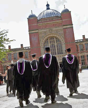
Graduates at the University of Birmingham
Plan 13 Selly Oak and South Edgbaston Spatial Plan
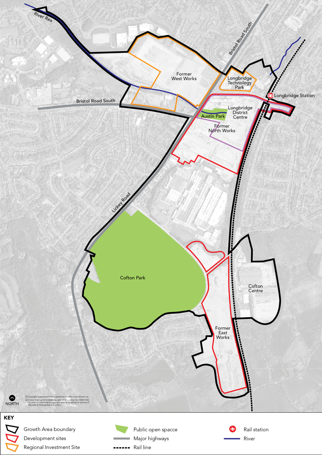
5.112 Following the closure of the MG Rover plant at Longbridge the City Council, in association with Bromsgrove District Council and other stakeholders, prepared the Longbridge Area Action Plan (AAP) to secure the comprehensive regeneration of this strategically important brownfield site that straddles the City boundary. The plan was adopted by the City Council in April 2009.
5.113 The AAP covers a developable area of approximately 130 ha. It has excellent transport connections with good access to the motorway network - being close to junctions with the M5 and M42. The A38, a major arterial route, crosses the area. It is also served by the Cross City rail line and Longbridge rail station immediately adjoins the site. Enhancements will be made to the station and its surrounding environment, improvements to bus services made, and a wayfinding strategy implemented to improve Longbridge's quality of place and connect neighbourhoods to employment opportunities.
| Policy GA10 Longbridge | ||||||||||||||
An AAP is in place for the area to secure comprehensive regeneration and guide future development over a 15-20 year period.
A total of 28,626 sq.m. of retail floorspace has been committed to date, reflecting changing circumstances since the AAP was adopted. Proposals for further retail development will only be permitted where it can be demonstrated through a full retail impact assessment that there will be Implementation
|
5.114 The AAP provides a 15-20 year framework for the comprehensive regeneration and development of the area. It sets out proposals for an exemplar sustainable employment led mixed use development to deliver 10,000 jobs and a minimum of 1450 new homes, a Regional Investment Site (RIS), a new local
centre, a Bio-mass CHP facility, new education facilities, retailing, leisure, community and recreation uses all underpinned by quality public transport facilities and highway infrastructure and other community infrastructure.
5.115 The AAP seeks to respond to the closure of the former MG Rover plant by proposing an employment led approach to regeneration. It seeks to create jobs across a range of skills and types, protecting existing employment, creating new employment and securing the economic diversification of the area. The RIS will contribute around 4,500 jobs and the new local centre and other employment sites will also result in the creation of significant new job opportunities.
5.116 All the proposals in the AAP emerged from extensive consultation with the local community, stakeholders and other key partners. For example, the new local centre responds to the need to provide a new heart for the community and improve the quantity and quality of retail provision in the area.
5.117 The AAP Delivery and Implementation Plan sets out the mechanisms, timescales and agencies involved in delivery of the AAP proposals. However, the Longbridge Infrastructure Tariff ceased to apply when the Community Infrastructure Levy for Birmingham was adopted in January 2016.
5.118 Since adoption of the AAP the area has been promoted to an ITEC park in recognition of its potential to provide for businesses requiring buildings with high specification fittings in a centre location and with excellent accessibility. Work is underway to secure investment in high quality digital infrastructure. The ITEC park will be mainly focussed on the RIS and local centre, however investment in this sector will also act as a catalyst in forging a vibrant residential community. 5.119 Extensive progress has been made in delivering the first phases of the RIS (Longbridge Technology Park) and key elements of the new local centre including the new college, retail hotel and offices and new urban park.
Plan 14 Longbridge Spatial Plan
< Previous | ^ Top | Next >